1815 - Wallace Kirkpatrick, of Scottish nationality, arrived in St. Charles from South Carolina. He was one of the first merchants in St. Charles, later residing on property near St. Charles and became a successful farmer. He married Miss Jane . . . — — Map (db m169215) HM
1830 - Part of the Nathan Boone Survey of the Common Fields.
1837 - 999-year lease for $4.62 ¾ per year to Dr. Andrew Wilson. Dr. Wilson worked as the coroner of St. Charles County, as well as other occupations. He was a relative of Woodrow . . . — — Map (db m169223) HM
1830 • Part of Nathan Boone's survey of the Commons.
1837 • Part of Dr. Andrew Wilson's lease of the Commons
1857 • Partitioned among the heirs of Dr. Andrew Wilson who subdivided the area as Wilson's subdivision.
1893 . . . — — Map (db m169220) HM
1830 - Part of Nathan Boone's survey of the Commons.
1837 - Part of Andrew Wilson's 999 years lease of the Common ground.
1870 - Lot number 6 of Boone's survey block 9 was subdivided between R. B. Fraysier and A. H. Edwards. . . . — — Map (db m133261) HM
1830 - Part of Nathan Boone's survey of the Commons.
1835 - Part of Andrew Wilson's Subdivision of the Commons.
1898 - Herman H. Hackman Jr., early dry goods merchant with Kuhlman - Hackman, and his wife Laura, purchased this lot from . . . — — Map (db m133259) HM
1830 - Part of the Nathan Boone survey of the Commons.
1835 - Lot 13 of the Riggs Subdivision
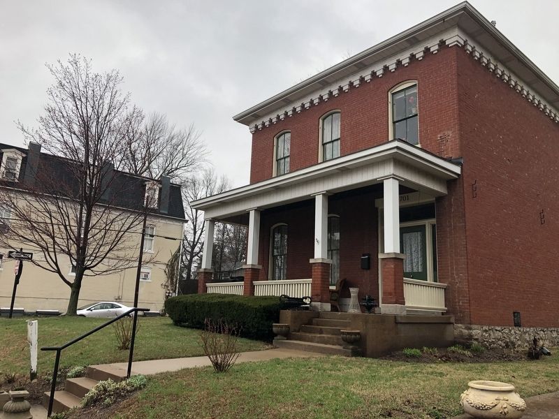
1904 - The three houses (709 - 713 - 717) were built at or about this time. They originally were identical. The style is Victorian Folk with . . . — — Map (db m133260) HM
1830 - Part of Nathan Boone's survey of the Commons
1837 - Part of Andrew Wilson's lease of the Commons.
1868 - Gustav - Paul was born to Wilhelm and Charlotte Paul.
1901 - Gustav A. Paul paid $2.50 tax on 50' x 140' lot for five . . . — — Map (db m133266) HM
1830 - Part of Nathan Boone's survey of the Commons.
1835 - Included in lease of the Commons by Andrew Wilson.
1939 - Easement for sewer recorded.
The house is believed to have been built at this time as well as the look-a-likes to . . . — — Map (db m133262) HM
1830: Part of Nathan Boone's survey of the Commons.
1857: Part of Jeremiah Fletcher Riggs Subdivision.
1867: Part of John Wilke's property. (Alley to Lewis) He was a Civil War veteran and bought 603 N. 6th Street. . . . — — Map (db m133257) HM
Ezra Overall owned this property and may have built this home. He was a local attorney and land speculator, selling dozens of properties. He sold this property to Frederick Maerklin. This building is a good example of a "single German" one story . . . — — Map (db m124804) HM
North 2nd Street Shops
North Second Street was a bustling thriving commercial district. Butchers, bakers, tinsmiths and saddle makers all had shops on the street; many lived above them on the second floor. Farmers brought their grain to the . . . — — Map (db m150983) HM
John Balthasar Borgemeier, a Hanoverian carpenter, built this home in 1852. He is reported to have owned much of this city block and built many of these historic homes. This home is one of the best examples of the French Colonial style of . . . — — Map (db m169571) HM
Stone Building
circa 1820
Residence and business of Sir Walter Rice, served at various times as County Surveyor, Recorder of Deeds, Justice of the Peace and Postmaster.
Brick Building
circa 1848
Original site of frame . . . — — Map (db m124821) HM
The Burlington stone used to construct these buildings was quarried from within this city block. Built by Thomas Lindsey, a founder of the first Presbyterian church in St. Charles. — — Map (db m124822) HM
During the 1850's and 1860's, this high ground on the southern outskirts of St. Louis evolved into an enclave of elegant homes. At that time Broadway was known as Carondelet Avenue, and this street, now DeMenil Place, was known as 2nd Carondelet. . . . — — Map (db m133199) HM
Henry Schaumburg, Jr. designed this storefront that was constructed in 1900. Schaumburg was one of South St. Louis' German-American architects who celebrated the abundance and variety of decorative brick available in St. Louis. His father was a . . . — — Map (db m124479) HM
In 1923, Cherokee Business Association raffled a house (on this site) that was furnished down to the coal in the coal bin, a car in the garage, and toothpicks in the pantry.
The bungalow, which faced 18th Street, was raffled on the night of . . . — — Map (db m133191) HM
This cake commemorates the 250th anniversary of Saint Louis' founding and has been painted to reflect the beautiful Victorian ceiling mural of the Lemp Mansion. The cake, one of 250 that have been placed around the St. Louis area, reflects the . . . — — Map (db m143749) HM
This building, originally known as "Cherokee Livery", was constructed in 1893 for undertaker Paul Buol. The original facade consisted of two large segmental arched bays enclosed with double doors for horse and carriage access. The second story . . . — — Map (db m124466) HM
On December 6, 1935, Edward A. Vanderventer was granted a permit to demolish a one-story brick residence on this lot. The razed building was one of five identical single story brick residences constructed by John B. Westermeyer in 1892. These . . . — — Map (db m124452) HM
This commercial and residential building was built in 1895 by owner Jeremiah Thompson and building contractor H.R. Becker. Throughout the 1890s Thompson used the space for his butcher shop, while residing on McNair Avenue. In 1911 George W. Starke . . . — — Map (db m124449) HM
The northeast corner of Cherokee Street and Iowa Avenue was the location of the Cinderella Airdome, which opened in 1921. The Airdome, which was an outdoor theater, was operated by Harry and Eugene Freund. The Freunds had built the Cinderella . . . — — Map (db m124458) HM
The Authority entered into a Relocation Agreement with the St. Louis Convention & Visitors Commission, Football at the New Stadium, Inc., and the Los Angeles Rams Football Company, Inc., for the Rams to relocate to St. Louis.
Nearly 1.6 . . . — — Map (db m141847) HM
The first tenant here wanted offices signifying its metals business. Thus, this 1967 building is clad in stainless steel. Notice, it is the same material as the Gateway Arch!
As stainless steel moves dramatically in hot and cold weather, it is . . . — — Map (db m151978) HM
Imagine four towers soaring 26 to 51 stories above the corner of Washington and Seventh Streets. Only one of the envisioned Mercantile Center buildings became reality, which stands in front of you, and was completed in 1976. — — Map (db m141140) HM
On this site Maxent, Laclede, & Company built the first structure in St. Louis. Unlike typical towns of that time, St. Louis was founded for trade, not for religious, farming, or defense purposes.
Pierre Laclede and Auguste Chouteau traveled . . . — — Map (db m236907) HM
In front of you is the iconic Gateway Arch. The natural curve of a hanging chain—a catenary curve—inspired the Arch design. Curves also define the landscape. You may not notice them at first, but there are curves throughout the park. . . . — — Map (db m124950) HM
The eight-story Merchant Laclede Building named after the merger of two of its bank tenants, is an early example of St. Louis’ tall fireproof office buildings. Completed in 1889, some of its offices contain fireplaces.
The building was . . . — — Map (db m78872) HM
On this site stood the Old Missouri Hotel. The first legislature convened here under the first state constitution on September 18, 1820. The year before Missouri was admitted to the Union. It was also the site of the inauguration of the first . . . — — Map (db m78840) HM
Dedicated to
the People of the United States
May 25, 1968
Lyndon B. Johnson
President of the United States
The City of St. Louis Missouri
The United States Territorial
Expansion Memorial Committee
[The Gateway Arch was . . . — — Map (db m26866) HM
The Security Building, one of St. Louis’ most significant 19th century office buildings, is the city’s only remaining commercial structure designed by the renowned architectural firm of Peabody & Stearns. Built in 1891, a year before Louis . . . — — Map (db m124964) HM
In 1891 the Wainwright Building was constructed for St. Louis businessman Ellis Wainwright. It was designed by Louis H. Sullivan, a Chicago architect.
The Wainwright Building is the father of the contemporary skyscraper. Sullivan's design . . . — — Map (db m141137) HM
This fountain by the sculptor Carl Milles symbolizes the union of the Mississippi and Missouri rivers · The two central figures represent the two great rivers while the lesser water creatures suggest the many tributaries and streams · Milles . . . — — Map (db m62213) HM
This property has been listed in the
National Register of Historic Places
by the United States Department of the Interior
Built in 1901 for the Lambert Deacon Hull Printing Company, this building is the work of St. Louis polymath Samuel . . . — — Map (db m145822) HM
This structure was built by O.L. Halsey by permission of the Packard Motor Car Co., to serve as St. Louis' Packard dealership and distributorship. It was designed by architect J.L. Wees. Halsey had been the first car dealer in St. Louis. By 1915, . . . — — Map (db m133081) HM
has been designated a
National
Historic Landmark
This site possesses national
significance in commemorating
the history of the
United States of America
———————
[Markers on interior . . . — — Map (db m62210) HM
This large sculpture portrays King Louie IX of France [1214-70], the namesake of the City of St. Louis, as a Christian soldier. His "apotheosis' or ascendance to the divine realm is suggested by the sword in the form of a cross and the energetic . . . — — Map (db m181257) HM
The serpentine wall and Kiener Memorial Entrance to the Zoo were designed by William Bernoudy in 1966.
William Bernoudy was a St. Louis-born architect who studied under Frank Lloyd Wright in the 1930s. He played a vital role in the . . . — — Map (db m133326) HM
Class Oldenburg produces monumental sculptures of every day consumer objects. In this work, an enormous three - way electrical plug lies partly buried in the ground . The artist has described it as resembling " an implement left over from a war, . . . — — Map (db m181261) WM
The World's Fair Pavilion was built in 1909 with proceeds from the 1904 World's Fair held here in Forest Park. Government Hill's colorfully lit fountain and reflecting pool were added in 1930. While the entire area had fallen into disrepair by . . . — — Map (db m139730) HM
Since its very beginning, the Saint Louis Zoo has been a leader in exhibit design. With the world's largest walk-through bird cage built for the World's Fair of 1904 and the open moated bear pits built in 1921, the Zoo combined good animal care with . . . — — Map (db m189234) HM
When the Jewel Box was dedicated in 1936, crowds flocked to experience its magnificent Art Deco design. The structure's unique construction of cantilevered glass supported by arched steel beams also proved a ground-breaking (but not . . . — — Map (db m139732) HM
Today's Nathan Frank Bandstand - a Classic in its Own Right
Dedicated in 1925 and built with white marble and concrete with bronze rails and a copper roof, the Nathan Frank Bandstand - restored in 2000 - is still a Forest Park and St. . . . — — Map (db m144817) HM
Though called the World's Fair Pavilion, this popular gathering spot was not built until 1909, five years after the Louisiana Purchase Exposition. Designed by Henry Wright, the pavilion was presented to the citizens of St. Louis by the Fair . . . — — Map (db m133327) HM
The double lot where this building sits was purchased July 5, 1867 by Dorothea Rathert from Henry Lipphardt. Rathert occupied a dwelling situated at the rear of the double lot before the present building was constructed. Previous to ordinances . . . — — Map (db m124465) HM
The original building constructed as a dwelling circa 1883, received several layers of additions as the years progressed. The Bogard family first inhabited the home and lived at this address for over twenty years. Musical instrument manufacture, . . . — — Map (db m124462) HM
On this site in 1891 John B. Westermeyer built five, one-story brick houses, identical to the houses he built across the street in 1892 and just to the west of here on Cherokee Street the same year. Most of the houses on this side of the block were . . . — — Map (db m124451) HM
The present building was originally constructed as a dwelling in the Fall of 1893 for Gertrude Muller. During the turn of the twentieth century this city block facing Cherokee Street was largely residential. Once a street car line was established on . . . — — Map (db m196102) HM
St. Louisans were taking up the new American pastime of bicycling when this storefront was built in 1888. They were reading Walt Whitman's poems in the Leaves of Grass and learning about Theodore Roosevelt's western experiences in Ranch . . . — — Map (db m124509) HM
This townhouse is typical of homes built in working-class neighborhoods during the 1880's. It is tall, narrow and features the then popular mansard roof. The foundation is roughcut stone and the facade is smooth brick with eyebrow arches over the . . . — — Map (db m124507) HM
This row of five almost identical homes was built in 1884 as investment property by German immigrant Philip Bardenheier. These working-class city houses featured recessed entrances, fully arched doorways and first floor windows. Originally, all five . . . — — Map (db m124487) HM
During the mid 19th century, German pioneers settling the open land south of St. Louis built homes in the style of this pair of houses, 1936 and 1938 Cherokee. Often they were built as farm houses. As the farm land evolved into the urban . . . — — Map (db m124510) HM
Courtyards, alley houses, shops on the first floors, second floor apartments — this combination and arrangement of residential and commercial uses were typical of mid-19th century neighborhoods crowded with immigrants.
Gradually during . . . — — Map (db m133196) HM
The Lemp family built this "Wagon House" in 1895 to house its fleet of delivery wagons and herd of horses that carried Lemp brews to far-flung retailers. A corral for the Percherons — the draft horses used by the Lemp Brewery — . . . — — Map (db m133193) HM
DuBourg Hall opened on July 31, 1888, bringing all of Saint Louis University's functions, including living quarters for the Jesuit faculty, under one roof. Stretching along Grand Boulevard for 270 feet, the building originally housed classrooms, a . . . — — Map (db m145066) HM
The England Woodland Garden has matured since 1976, when former Curator of Hardy Plants John Elsley brought the idea from his native England to the Missouri Botanical Garden and spurred its development. What started out as a one-and-one-half-acre . . . — — Map (db m219457) HM
In Henry Shaw's time this area was a relatively flat and completely covered with formal gardens. In 1912 landscape architect John Noyes turned it into the Knolls, a more natural, rolling landscape with grass and a stream. In 1982, the present dry . . . — — Map (db m219272) HM
This Ottoman-style walled garden, the first of its kind in the United States, is modeled on the luxurious Turkish "Gardens of Paradise" of the 17th and 18th centuries. Fragrant flowers and aromatic herbs surround the center focal point, a shallow . . . — — Map (db m219251) HM
Designed by George I. Barnett and built in accordance with Henry Shaw's will, this cottage was constructed in 1895 as a residence for the groundskeeper of the Mausoleum grounds, Museum Building, and surrounding gardens. Based on the roof design, . . . — — Map (db m219282) HM
The Bell Chimes sculpture was a collaborative effort by William C. Severson and Vernon Desmond Gross, both St. Louis sculptors. The idea for the piece came from Alan Godlewski, past Garden Director of Horticulture 1978 - 1988. He was inspired . . . — — Map (db m219252) HM
Hedge mazes are thought to have evolved from "knot gardens" of Renaissance Europe, and were first constructed during the mid-16th century. Many Victorian gardens had plantings like this that were both fanciful and mysterious.
Several mazes . . . — — Map (db m219387) HM
Carl was fond of angels and created them for several large fountains. These three angels are replicas of a few of his angels from fountains in the following U.S. cities: Falls Church, Philadelphia, and Kansas City. Each plays a different . . . — — Map (db m219266) HM
Within the wrought-iron fence, sheltered beneath the majestic oaks and sassafras trees, lies the final resting place of Garden founder Henry Shaw. The peaceful and tranquil design of this garden celebrates Shaw's English heritage. As you meander . . . — — Map (db m219509) HM
Many Victorian gardens had buildings and plantings that were fanciful, romantic and mysterious. The maze, revived as a garden element at the beginning of the 19th Century, exemplifies these qualities.
Henry Shaw could have been inspired by . . . — — Map (db m219389) HM
Sculptor Carl Milles (1875 - 1955) dominated the Swedish art world during the first half of the 20th century. These even sculptures span the early, middle, and late phases of Carl Milles' long career. Gliding across the water or soaring in the . . . — — Map (db m219267) HM
Constructed between 1859 and 1860, this neoclassic building is one of only five original structures at the Garden by Henry Shaw. While the exterior was designed by George l.Barnett, the interior resembles Museum No. 2, the Economic Botany Museum . . . — — Map (db m78882) HM
Henry Shaw was a 19th century English-born businessman who lived most of his life in St. Louis. The gardens he created here and in Tower Grove Park had many elements of the Victorian-era British garden.
In St. Louis, there were two . . . — — Map (db m219388) HM
Flora Gate, as it was originally known, was constructed by Henry Shaw in 1858 (thus the external inscription), one year prior to the Garden's public opening in 1859. As the original entrance, it served to align the Garden's axis, which gives rise . . . — — Map (db m219260) HM
This garden is dedicated to some of the oldest friends of humanity: herbs. Herbs have historically been valued for their fragrance, utility, medicinal properties, and culinary use.
Thanks to the generous support of the St. Louis Herb . . . — — Map (db m219504) HM
Constructed between 1859 and 1860, this neoclassical building is one of only five original structures at the Garden built by Henry Shaw. While the exterior was designed by George I. Barnett, the interior resembles Museum No. 2, the Economic . . . — — Map (db m121586) HM
Constructed between 1859 and 1860, this neoclassical building is one of only five original structures at the Garden built by Henry Shaw. While the exterior was designed by George I. Barnett, the interior resembles Museum No. 2, the Economic . . . — — Map (db m219379) HM
This unique garden honors the Victorian style of taking woody material, like trunks and root wads, and creating a natural habitat for shade loving plants. A root wad is a length of downed tree that includes portions of the trunk and root mass. . . . — — Map (db m219448) HM
Extensive renovations in 2012 transformed this once-enclosed garden into an expansive vista, favored in Henry Shaw's day. this garden has been carefully designed to enhance your view down the vista and to complement the architectural style of the . . . — — Map (db m219228) HM
The gardens Henry Shaw created here and in Tower Grove Park had many elements of the Victorian-era gardens. In St. Louis, there were two well-known observatories, both of which were constructed by Shaw.
The first one he built in 1863 was . . . — — Map (db m219386) HM
This picturesque landscape was designed by John Noyes who served as the Garden's landscape architect from 1913 to 1934. Since 1914, the Knolls provides a scenic vista between the Milles Sculpture Garden and Henry Shaw's Mausoleum Garden. the . . . — — Map (db m219280) HM
Between 1849 and 1851, architect George I. Barnett simultaneously designed Henry Shaw's city and country residences. Tower Grove House was Shaw's elegant Italianate country home. Making a dramatic impression against the landscape, it was designed . . . — — Map (db m121580) HM
Pincushion gardens were first introduced in the 1850s at Putteridge Bury in Hertfordshire, England when an avenue of circular beds or "pincushions" were arranged symmetrically along a path. In the 1990s pincushion beds were featured here at the . . . — — Map (db m219384) HM
Jefferson National Expansion Memorial
Gateway Arch
• The Gateway Arch is a 630 feet tall stainless steel structure designed by famous architect Eero Saarinen. It symbolizes St. Louis's role as the gateway to the west.
• A tram takes . . . — — Map (db m144261) HM
This property has been
placed on the
National Register
of Historic Places
by the United States
Department of the Interior
Circa 1870 — — Map (db m219549) HM
In 1848, Heinrich (Henry) Becker purchased this lot from Benjamin Soulard. Becker subsequently built this two-unit Federal-style flounder house. Its first story was originally a storefront for the family's brick-making business. Kilns, an alley . . . — — Map (db m160367) HM
This corner commercial space with apartments above was the quintessential 1890s city building model. Bricklayer Hy Debus built this structure for Schatz's Grocery. The Star of David topping the façade celebrated the Schatz family faith, and the . . . — — Map (db m158932) HM
Possibly dating to pre - 1870, the Brunelle House was built by architect Nathan D. Allen as a single family home for stone-quarry owner Henry Brunelle. Originally built on 3 lots, this 3 story home sits upon a limestone basement which tops a . . . — — Map (db m159516) HM
The Brewhouse with its dominant clocktower is the heart of the St. Louis brewery.
Since 1852
[Additional plaque nearby]
Anheuser-Busch Brewery
has been designated a
Registered National
Historic . . . — — Map (db m133140) HM
History
The area known as Soulard was once part of the estate of Antoine and Julia Soulard. Antoine came to St. Louis via New Orleans, having left France to literally save his head - he was a loyalist to King Louis XVI. Once in St. Louis he . . . — — Map (db m189727) HM
This two-story structure is Federal style architecture, with a gabled roof, six over six windows, and a corbelled cornice. Small, mixed use commercial and residential structures were common in this densely-populated walking city. This building was . . . — — Map (db m160365) HM
The original Lafayette School stood on this site in the middle of the 19th Century. The elementary school was named for Marie Jean Paul Lafayette, French-born American Revolutionary War hero. In 1906, architect William B. Ittner designed a new, . . . — — Map (db m160366) HM
Louis Obert was born in Germany in 1845 and emigrated to St. Louis in 1866. Obert purchased the Arsenal Brewery in 1876. Located across the street and slightly south, the brewery produced the flagship brand Tannhauser. A contemporary of Adolphus . . . — — Map (db m159007) HM
Originally this land contained a bottling shed for Arsenal Brewery. In 1937, city architect Albert Osberg (who also designed Soulard Market) designed a series of Art Deco police stations for the St. Louis Metropolitan Police Department. This . . . — — Map (db m159009) HM
Max Feuerbacher was owner of the Green Tree Brewery. When he built this home, he was the first to flank a private residence with stone lions-hence the mansion's nickname "The Lion House." The cupola on the roof provides long-ranging views of . . . — — Map (db m158881) HM
2105 Menard St. was the first & middle house of the "Menard Triplets". Back half built in 1850 & front portion added in late 1870's. Once vacant & vandalized, the house was restored in 1985 with interior pieces from the old Laclede Gas Bldg, the . . . — — Map (db m158879) HM
This pre-Civil War home originally had a Federal-style slanted roof. In 1875, the mansard roof, cornice, side conservatory, and Italianate and Second Empire façade were added by quarry owner Philip W Schneider. Nicknamed "Granite Schneider," his . . . — — Map (db m160370) HM
Originally built as a hipped-roof flounder on the north of two lots, this early 1850s home started as just two rooms. Built by store owner Renault Beauvais, the home faced Lami Street. Enlarged in the 1870s to add a kitchen, this single-family home . . . — — Map (db m159515) HM
The lots were sold at Auction in 1865 with the dissolution of the French common fields. This connected series of Victorian style red brick townhouses has four-level, high bay windows on the façade with mansard roofs. The six homes may be similar, . . . — — Map (db m159008) HM
This three-story Georgian revival-style building with turrets incorporates a Queen Anne tower topped with a 'witches hat' roof. The owner-builder, Henry Ruckert, completed the structure in 1889 at a cost of $140,000. He placed his initials and the . . . — — Map (db m163827) HM
This is the oldest farmers market west of the Mississippi. The land was owned by the Soulard family. In 1841, Julia Cerre Soulard, widow of Antoine Soulard, donated two city blocks to the people of St. Louis to preserve the market's future. The . . . — — Map (db m158651) HM