After filtering for Vermont, 125 entries match your criteria. The first 100 are listed. ⊳
Industry & Commerce Topic
By Kevin Craft, August 1, 2014
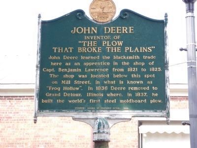
Update Photo - - John Deere Marker
| 1 ► Vermont, Addison County, Middlebury, Bread Loaf — John Deere — Inventor of "The Plow that Broke the Plains" — |
| On Main Street, 0.1 miles south of Mill Street, on the right when traveling south. | |||
| 2 ► Vermont, Addison County, Middlebury, Bread Loaf — Marble Works Memorial Bridge — |
| Near Mill Street just west of Park Street, on the right when traveling west. | |||
| 3 ► Vermont, Addison County, Middlebury, Bread Loaf — The Addison County Courthouse — |
| On Court Street (U.S. 7) near Washington Street, in the median. | |||
| 4 ► Vermont, Addison County, Middlebury, Frog Hollow Area — Mill District — |
| On Mill Street west of Vermont Route 30, on the right when traveling west. | |||
| 5 ► Vermont, Addison County, Ripton — Robert Frost Wayside — Robert Frost Country: Moments in Time — |
| On Vermont Route 125 at Robert Frost Road, on the right when traveling west on State Route 125. | |||
| 6 ► Vermont, Addison County, Vergennes — Commerce at the Crossroads — |
| On Main Street (Vermont Route 22A), on the left when traveling north. | |||
| 7 ► Vermont, Addison County, Vergennes — Macdonough Shipyard — |
| Near Macdonough Drive, 0.3 miles west of Main Street (Vermont Route 22A). | |||
| 8 ► Vermont, Bennington County, Bennington — Shaffe’s — c. 1850/1963 — |
| On Main Street (Vermont Route 9) at School Street, on the right when traveling east on Main Street. | |||
| 9 ► Vermont, Bennington County, Dorset — Fenton Pottery Site — 1801-1810 — |
| On Dorset Hollow Road at Kirby Hollow Road, on the right when traveling south on Dorset Hollow Road. | |||
| 10 ► Vermont, Bennington County, Dorset — First Marble Quarry — Oldest Quarry in U.S., 1785 — |
| On Vermont Route 30 at Kelly Road, on the right when traveling north on State Route 30. | |||
| 11 ► Vermont, Bennington County, East Rupert — Harmon's Mint — East Rupert — |
| On Vermont Route 30, on the right when traveling north. | |||
| 12 ► Vermont, Bennington County, North Bennington — The Paper Mill Village Bridge — |
| On Murphy Road, 0.1 miles south of N Bennington Road (Vermont Route 67A), on the right when traveling north. | |||
| 13 ► Vermont, Bennington County, North Bennington — McWaters Park — |
| On River Road at Murphy Road, on the left when traveling west on River Road. | |||
| 14 ► Vermont, Bennington County, North Bennington — Paper Mill History / Covered Bridges Span Rivers And Time — |
| On Murphy Road, 0.1 miles south of N Bennington Road (Vermont Route 67A), on the left when traveling north. | |||
| 15 ► Vermont, Bennington County, Old Bennington — Site of the Catamount Tavern - 1767 — |
| On Monument Avenue near Highway 9. | |||
| 16 ► Vermont, Bennington County, Pownal, North Pownal — The North Pownal Mill Site — |
| On Dean Road west of Vermont Route 346, on the left when traveling west. | |||
| 17 ► Vermont, Bennington County, Sunderland, Arlington — Chiselville — |
| On Sunderland Hill Road, on the right when traveling north. | |||
| 18 ► Vermont, Caledonia County, Barnet — Ben's Mill — |
| On West Barnet Road, on the left. | |||
| 19 ► Vermont, Caledonia County, Barnet — Henry Stevens / Henry Stevens, Jr. — |
| On U.S. 5, on the right when traveling north. | |||
| 20 ► Vermont, Caledonia County, Barnet — The Comerford Development at Fifteen Mile Falls — |
| On Interstate 91 at milepost 121.8, on the right when traveling north. | |||
| 21 ► Vermont, Caledonia County, Danville — Greenbank's Hollow — A Forgotten Village — |
| On Greenbanks Hollow Road at Brook Road, on the right when traveling south on Greenbanks Hollow Road. | |||
| 22 ► Vermont, Caledonia County, East Burke — Mountain View Farm — |
| On Darling Hill Road at East Darling Hill Road, on the right when traveling south on Darling Hill Road. | |||
| 23 ► Vermont, Caledonia County, Lyndon Center, Lyndonville — Vail Campus — |
| On Center Street (Vermont Route 122) at College Road, on the right when traveling north on Center Street. | |||
| 24 ► Vermont, Caledonia County, Lyndonville — Theodore N. Vail — Pioneer in Creating the Telephone Industry — |
| On College Road, 1 mile Center Street (Vermont Route 122), on the left when traveling south. | |||
| 25 ► Vermont, Caledonia County, St Johnsbury, St. Johnsbury — Green Mountain Supermarket — |
| On Railroad Street north of Eastern Avenue, on the left when traveling north. | |||
| 26 ► Vermont, Caledonia County, St. Johnsbury — First American Platform Scale |
| On Portland Street (U.S. 2) at Spaulding Road, on the right when traveling east on Portland Street. Reported permanently removed. | |||
| 27 ► Vermont, Caledonia County, St. Johnsbury — First American Platform Scale — |
| On Western Avenue (U.S. 2) at Mount Vernon Street, on the right when traveling east on Western Avenue. | |||
| 28 ► Vermont, Chittenden County, Burlington — Church Street — Burlington, VT — |
| On Main Street (U.S. 2) at Church Street, on the right when traveling west on Main Street. | |||
| 29 ► Vermont, Chittenden County, Burlington — Exchange Block — 1878 — |
| On Main Street at Church Street, on the right when traveling west on Main Street. | |||
| 30 ► Vermont, Chittenden County, Burlington — Site of the Old Gas Station — |
| Near College Street at St. Paul Street. | |||
| 31 ► Vermont, Chittenden County, Burlington, Old North End — Church Street Marketplace — |
| On Pearl Street at Church Street, on the right when traveling east on Pearl Street. | |||
| 32 ► Vermont, Chittenden County, Burlington, South End — Church Street Marketplace — |
| On Main Street at Church Street, on the right when traveling west on Main Street. | |||
| 33 ► Vermont, Chittenden County, Burlington, South End — Ground Beneath Your Feet — Burlington Heritage Trail — |
| Near Maple Street, 0.2 miles west of Railway Lane. | |||
| 34 ► Vermont, Chittenden County, Jericho — Chittenden Mills — |
| On Vermont Route 15 at Red Mill Drive, on the right when traveling west on State Route 15. | |||
| 35 ► Vermont, Chittenden County, Richmond — Huntington Gorge / Deaths at the Huntington Gorge — Site of Richmond’s first grist mill and electric generating plant — |
| On Dugway Road, 1.5 miles east of Huntington Road, on the right when traveling north. | |||
| 36 ► Vermont, Chittenden County, Shelburne — Apothecary Shop — Constructed on-site: 1959 — |
| 37 ► Vermont, Chittenden County, Shelburne — Blacksmith Shop — Ca. 1800 • Shelburne, Vermont — Moved to Museum: 1956 — |
| 38 ► Vermont, Chittenden County, Shelburne — Dutton House — 1782 • Cavendish, Vermont • Original Owner: Salmon Dutton — Moved to Museum: 1950 — |
| 39 ► Vermont, Chittenden County, Shelburne — General Store — 1840 • Shelburne, Vermont — Moved to Museum: 1953 — |
| 40 ► Vermont, Chittenden County, Shelburne — Hat and Fragrance Textile Gallery — Ca. 1800 • Shelburne, Vermont — Original Owner: Captain Benjamin Harrington • Moved to Museum 1947 — |
| 41 ► Vermont, Chittenden County, Shelburne — Horseshoe Barn Annex — Constructed on-site: 1957 — |
| 42 ► Vermont, Chittenden County, Shelburne — Jail — 1890 • Castleton, Vermont • Moved to Museum: 1953 — |
| 43 ► Vermont, Chittenden County, Shelburne — Locomotive 220 — |
| 44 ► Vermont, Chittenden County, Shelburne — Print Shop — Constructed on-site: 1955 — |
| 45 ► Vermont, Chittenden County, Shelburne — Rail Car Grand Isle — 1899 • Wagner Palace Car Company • Moved to Museum: 1960 — |
| 46 ► Vermont, Chittenden County, Shelburne — Railroad Station — 1890 • Shelburne, Vermont • Moved to Museum: 1959 — |
| 47 ► Vermont, Chittenden County, Shelburne — Sawmill — Constructed on-site: 1957 — |
| 48 ► Vermont, Chittenden County, Shelburne — Settlers' House and Barn — 1846 • East Charlotte, Vermont • Moved to Museum: 1955 — |
| 49 ► Vermont, Chittenden County, Shelburne — Shaker Shed — 1840 • Canterbury, New Hampshire — Moved to Museum: 1951 — |
| 50 ► Vermont, Chittenden County, Shelburne — Smokehouse — Ca. 1820 • Charlotte, Vermont • Moved to Museum: 1949 — |
| 51 ► Vermont, Chittenden County, Shelburne — Stagecoach Inn — Ca. 1787 • Charlotte, Vermont — Original Owner: Hezekiah Barnes • Moved to Museum: 1949 — |
| 52 ► Vermont, Chittenden County, Shelburne — Stone Cottage — Ca. 1840 • South Burlington, Vermont — Moved to Museum: 1949 — |
| 53 ► Vermont, Chittenden County, Shelburne — The Rail Car Grand Isle — |
| 54 ► Vermont, Chittenden County, Shelburne — Toy Shop — Constructed On-site: ca. 1949 — |
| 55 ► Vermont, Chittenden County, Shelburne — Weaving Shop — Constructed on-site: 1955 — |
| 56 ► Vermont, Essex County, Brighton — Charles F. Maw — (1883-1970) — |
| On East Brighton Road (Vermont Route 105) at Cross Street (Vermont Route 114), on the left when traveling west on East Brighton Road. | |||
| 57 ► Vermont, Franklin County, Enosburg Falls — Patent Medicine in Enosburg Falls — |
| On North Main Street, on the right when traveling north. | |||
| 58 ► Vermont, Franklin County, St. Albans Bay, Saint Albans Bay — Lucrative Trade to Leisure Vacations/Du commerce lucratif au voyage d'agrément — |
| Near Lake Street (Vermont Route 36) at Georgia Shore Road. | |||
| 59 ► Vermont, Grand Isle County, Isle La Motte — Sweet's Ferry — |
| On West Shore Road at School Street, on the right when traveling south on West Shore Road. | |||
| 60 ► Vermont, Grand Isle County, South Hero — Ebenezer Allen — Site of pioneer's tavern — |
| On South Street at U.S. 2, on the left when traveling south on South Street. | |||
| 61 ► Vermont, Orange County, Bradford — Bradford — Home of Maker of 1st Globes and Birthplace of Adm. Clark — |
| On Main Street (U.S. 5) 0.1 miles south of Bank Street, on the right when traveling south. | |||
| 62 ► Vermont, Orange County, Bradford — Bradford — James Wilson, Globe Maker — |
| Near Interstate 91 at milepost 99.8. | |||
| 63 ► Vermont, Orange County, Fairlee — Samuel Morey — Pioneer Inventor of Steam and Gas Engines lived here — |
| On Main Street (U.S. 5) 0.1 miles north of School Street, on the right when traveling north. | |||
| 64 ► Vermont, Orange County, South Strafford — Elizabeth Mine — |
| On Mine Road, 0.1 miles north of Copperas Road, on the right when traveling north. | |||
| 65 ► Vermont, Orange County, Strafford — Old City and Old City Falls — |
| On Old City Falls Branch, 0.9 miles north of Justin Morrill Memorial Highway, on the left when traveling north. | |||
| 66 ► Vermont, Orange County, Strafford, South Strafford — Furnace Flat — |
| On Vermont Route 132 at Furnace Flats Road, on the left when traveling east on State Route 132. | |||
| 67 ► Vermont, Orange County, Williamstown — Davenport Birthplace — |
| On Brook Street (Vermont Route 64) at Vermont Route 14, on the right when traveling west on Brook Street. | |||
| 68 ► Vermont, Orange County, Williamstown — Thomas Davenport — Inventor of the electric motor — |
| On Vermont Route 14 at Brook Street (Vermont Route 64), on the right when traveling south on State Route 14. | |||
| 69 ► Vermont, Orleans County, Barton — Henry M. Leland — Designer of Cadillac and Lincoln Automobiles — |
| On Church Street (Vermont Route 16) 0.1 miles south of Main Street (U.S. 5), on the right when traveling south. | |||
| 70 ► Vermont, Orleans County, Newport — 9 — Early 20th Century, Newport / Newport au début du 20e siècle |
| On Main Street (U.S. 5) at Field Avenue, on the right when traveling west on Main Street. Reported missing. | |||
| 71 ► Vermont, Orleans County, Newport — History of Hydropower on the Lower Clyde River — |
| On Crawford Farm Road south of Clyde Street, on the left when traveling south. | |||
| 72 ► Vermont, Orleans County, Newport — 5 — Newport's Hotels and Tourism / Les Hotels de Newport et le Tourisme — |
| On Main Street (U.S. 5) west of Railroad Square, on the right when traveling west. | |||
| 73 ► Vermont, Orleans County, Newport — 4 — The Arrival of the Railroad / L'Arrivée du Chemin de Fer — |
| On Causeway Street (U.S. 5) near Main Street (U.S. 5), on the right when traveling south. | |||
| 74 ► Vermont, Orleans County, Newport — 3 — Tour Boats on the Lake / Les Bateaux de Randonnée sur le Lac — |
| 75 ► Vermont, Rutland County, Belmont, East Wallingford — Village of Mechanicsville — Founded in Early 1800's — |
| On Tarbellville Road, 0.1 miles west of Belmont Road, on the right when traveling west. | |||
| 76 ► Vermont, Rutland County, Brandon — Forest Dale Ironworks — |
| On Forest Dale Road (Vermont Route 73) 0.4 miles east of North Street (Vermont Route 53), on the right when traveling west. | |||
| 77 ► Vermont, Rutland County, Brandon — Stephen A. Douglas — Opponent of Abraham Lincoln — |
| On Grove Street (U.S. 7) at Champlain Street (Vermont Route 73), on the right when traveling south on Grove Street. | |||
| 78 ► Vermont, Rutland County, Brandon — Thomas Davenport — 1802-1851 — |
| On Forest Dale Road (Vermont Route 73) south of North Street (Vermont Route 53), on the left when traveling south. | |||
| 79 ► Vermont, Rutland County, Castleton, Bomoseen — Edwin L. Drake — 1819-1880 — Founder of the Oil Industry — |
| On Alternate U.S. 4 at Drake Road, on the right when traveling west on U.S. 4Alternate . | |||
| 80 ► Vermont, Rutland County, Castleton, Bomoseen — Slate Pencil Manufacturing — (1843-1878) — |
| On North Road at Pencil Mill Road, on the right when traveling west on North Road. | |||
| 81 ► Vermont, Rutland County, Center Rutland — Mead's Falls — |
| On Business U.S. 4 at Simons Ave., on the right when traveling east on U.S. 4Business . | |||
| 82 ► Vermont, Rutland County, Clarendon, North Clarendon — Kingsley Grist Mill — |
| On Gorge Road at East Street on Gorge Road. | |||
| 83 ► Vermont, Rutland County, Cuttingsville — John Porter Bowman and Laurel Hall / Laurel Glen Mausoleum — |
| On Vermont Route 103, 0.7 miles north of Freeman Brook Road, on the left when traveling north. | |||
| 84 ► Vermont, Rutland County, Fair Haven — First Slate Quarry in Western Vermont — |
| On Scotch Hill Road, 1 mile north of U.S. 4, on the right when traveling south. | |||
| 85 ► Vermont, Rutland County, Fair Haven — Matthew Lyon — Fair Haven's oldest mills built on falls by founder — |
| On Main Street (Alternate Vermont Route 22) at Alternate Vermont Route 4, on the right when traveling south on Main Street. | |||
| 86 ► Vermont, Rutland County, Mendon — Edward Hastings Ripley — November 11, 1839 - September 14, 1915 — |
| On U.S. 4 at Esquiline Parkway, on the right when traveling south on U.S. 4. | |||
| 87 ► Vermont, Rutland County, Middletown Springs — A. W. Gray & Sons — |
| On South Street (Vermont Route 133) at Montvert Road, on the left when traveling south on South Street. | |||
| 88 ► Vermont, Rutland County, Pittsford — Kendrick Dam, Pond, Mill, and Ice House — |
| On Plains Road, 1 mile east of U.S. 7, on the left when traveling east. | |||
| 89 ► Vermont, Rutland County, Pittsford — Pittsford's Iron Industry — |
| On Vermont Route 7, on the right when traveling north. | |||
| 90 ► Vermont, Rutland County, Poultney — The Vermont Slate Industry — |
| On Main Street west of Grove Street (Vermont Route 30), on the right when traveling west. | |||
| 91 ► Vermont, Rutland County, Proctor — Vermont Marble Company — The Largest Marble Company in the World — |
| On Main Street, on the right when traveling north. | |||
| 92 ► Vermont, Rutland County, Rutland — John Deere — Birthplace — |
| On South Main Street (U.S. 4) at West Street (Business U.S. 4), on the right when traveling south on South Main Street. | |||
| 93 ► Vermont, Rutland County, Rutland — Stone Legacy — |
| 94 ► Vermont, Rutland County, Wallingford — Old Stone Shop — Built in 1848, by Batcheller & Sons, makers of pitchforks — |
| On S. Main Street (U.S. 7) 0.1 miles south of Church Street, on the right when traveling north. | |||
| 95 ► Vermont, Rutland County, West Pawlet — West Pawlet — Delaware & Hudson Rail Trail — |
| On Egg Street at County Route 29, on the left when traveling west on Egg Street. | |||
| 96 ► Vermont, Washington County, Calais, Adamant — Clarence W. Fitch — Community Activist — |
| On Quarry Road at Adamant Road, on the right when traveling north on Quarry Road. | |||
| 97 ► Vermont, Washington County, East Barre — Historic Millstone Hill — East Barre — |
| On Websterville Road at Church Street, on the left when traveling east on Websterville Road. | |||
| 98 ► Vermont, Washington County, East Montpelier — North Montpelier Historic District — |
| On Vermont Route 14 at Factory Street, on the right when traveling south on State Route 14. | |||
| 99 ► Vermont, Washington County, Graniteville — In the late 1950’s Rock of Ages experimented with making lanes out of granite... — |
| Near Graniteville Road. | |||
| 100 ► Vermont, Washington County, Montpelier — Main Street Bridge & F.W. Bailey Mill, Circa 1920 — |
| On Stonecutters Way, on the left when traveling north. | |||
125 entries matched your criteria. The first 100 are listed above. The final 25 ⊳