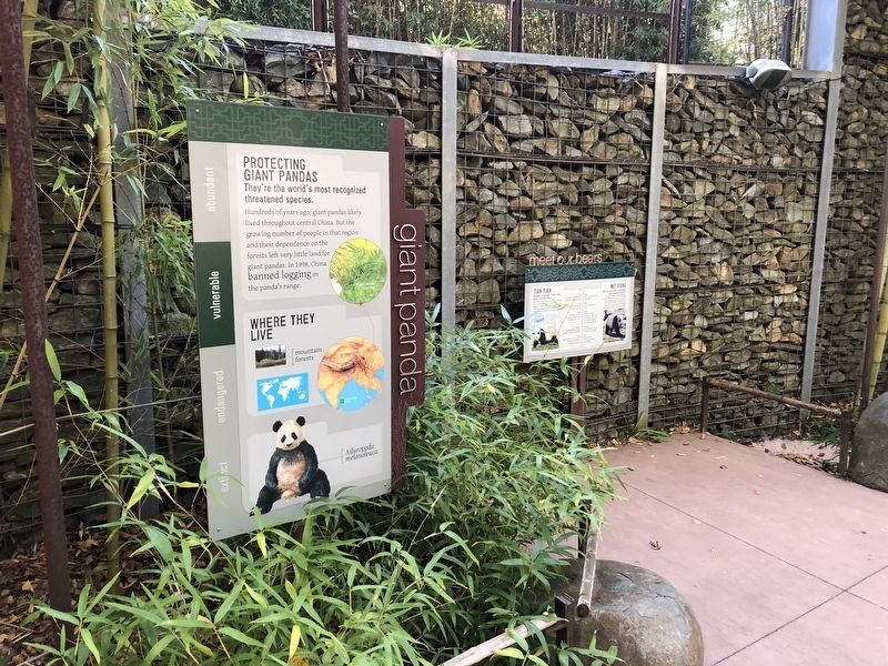
They're the world's most recognized threatened species.
Hundreds of years ago, giant pandas likely lived throughout central China. But the growing number of people in that region and their dependence on the forests left very little land . . . — — Map (db m184388) HM
In the early 1990s, Smithsonian Migratory Bird Center (SMBC) scientists found that shade farms, where coffee is grown within forest-like settings, provide refuge for migratory and resident birds, in contrast to conventional open-sun coffee farms . . . — — Map (db m111643) HM
Conservation Status
Least Concern: Species is currently not threatened.
What's Happening to the Ostrich?
Wild populations of the common ostrich have declined but, in general, the species is not considered . . . — — Map (db m201251) HM
There are fewer than 10,000 red pandas alive today.
People have long-hunted red pandas for their rich, soft pelts. Also, expanding human populations have taken over their mountain habitat, reducing the wild places where red pandas . . . — — Map (db m184411) HM
"We dedicate this building to the students of American University who here will discover an increasing fountain of knowledge and to that great body of students who in future days will here assemble."
(From a "Ritual . . . — — Map (db m117837) HM
Established in 1984, Takoma Station Tavern was born of a vision of Bobby Boyd (1934-2011). Mr. Boyd envisioned an entertainment complex not as an entrepreneurial venture but a venue that incorporated the spirit of family, community and unwavering . . . — — Map (db m113984) HM
1922
Ground Breaks
Community leaders formed Takoma Theatre Corporation to construct an entertainment house and a community auditorium. They commissioned architect John J. Zink, who later designed other movie houses in the area such as the . . . — — Map (db m193056) HM
Community
The Victory Garden Program brought many different groups together to support a single cause. Corporations, private foundations, magazine publishers, and seed companies all contributed to the success of the project. These . . . — — Map (db m164278) HM
Sustainability
As well as encouraging people to grow their own produce, the Victory Garden Program urged Americans to conserve and ration raw materials needed for the war effort, such as cans, fuel, rubber, glass jars, and wax paper. . . . — — Map (db m164276) HM
More than 1,200 wildlife species in the United States—including mammals, birds, fish, reptiles, amphibians, and insects—depend on dead or dying wood for their habitats.
What's the Snag?
A snag is a standing dead, or dying, tree. Snags . . . — — Map (db m188503) HM
Butterflies and bees love this plant, and so do people! Anise hyssop is named for its licorice-like scent. Used for tea by early Native Americans, it is also delicious in jellies and even cookies. The Latin word foeniculum refers to . . . — — Map (db m164289) HM
Butterfly weed is used for both fiber and medicine. Like other milkweeds, butterfly weeds have seeds that drift away on the wind with a silky parachute called floss.
Did you know that American children helped out during World War II by . . . — — Map (db m211401) HM
Cascade hops were originally developed by the U.S. Department of Agriculture in Oregon in the 1960s, as a powdery mildew-resistant cultivar. Due to their strong, bitter flavor, they weren't initially popular, but after the price of German hops . . . — — Map (db m211421) HM
Although we may associate fungi with rotting food and fungal diseases, these incredible organisms play a beneficial role in our lives, from the plants we grow to the foods we eat to the medicine we take.
Improving the Soil
Fungi help . . . — — Map (db m164224) HM
Clever gardeners used plants to overcome obstacles, and found solutions to allow desired plants to thrive.
Whether with a lack of resources or an abundance of opportunity many minds came together to create networks and industries to serve . . . — — Map (db m211389) HM
Clever gardeners used plants to overcome obstacles, and found solutions to allow desired plants to thrive.
Whether with a lack of resources or an abundance of opportunity many minds came together to create networks and industries to serve . . . — — Map (db m211400) HM
Building the Nation
The use of live oaks played a critical role in helping the nation grow from a colony to what it became—the United States of America. Ships were an essential means of transportation for moving people and products, and . . . — — Map (db m143312) HM
The Live Oak
Look up. The branches above you belong to the Southern live oak (Quercus virginiana), also known simply as the live oak. This tree gets its name because it's evergreen; unlike other oaks, it doesn't lose its leaves in . . . — — Map (db m143309) HM
The Live Oak
Look up. The branches above you belong to the Southern live oak (Quercus virginiana), also known simply as the live oak. This tree gets its name because it's evergreen; unlike other oaks, it doesn't lose its leaves in . . . — — Map (db m211382) HM
Beginning in 1815, a water transport canal was opened joining the Potomac river and the Anacostia river, then known as the Eastern Branch. The Washington Canal brought building supplies for construction of many buildings in the young city. The canal . . . — — Map (db m105992) HM
This house witnessed the building of the C&O Canal. Abner Cloud, a miller who had come here from Pennsylvania, built the house in 1801. Cloud's mill was about 200 yards upstream. The basement of the house was used by Cloud to store grain and . . . — — Map (db m722) HM
Baking bread, frying cornbead and eating "stick to your ribs" oatmeal, all have one thing in common; their ingredients started out at a grist mill. Decades before the sounds of lockhorns and mule hooves clopping by, mills were popping up along . . . — — Map (db m129837) HM
Here, in 1876, an engineering marvel was built. The largest incline plane in the world and the first built in the United States, carried canal boats to and from the Potomac River. The incline plane was used to help clear heavy boat traffic in . . . — — Map (db m129838) HM
Joseph Moor, a manumitted African American, lived on this tract of land, known as Whitehaven and later as Vineyard Hills, for several years in the early 1800s. Moor worked in Thomas Main's nursery and learned to cultivate honey locusts, firethorns, . . . — — Map (db m237620) HM
The Potowmack Company Outlet at Lock Harbor
You are standing on land that once belonged to the Potowmack Company. Created in 1785, the company aimed to make the Potomac River more navigability for trade by building a five-part . . . — — Map (db m238215) HM
Inhabitants
When Captain John Smith first sailed up the Potomac in 1608, he encountered several Native American villages on both sides of the river in what was later to become the District of Columbia. Various names have been assigned to . . . — — Map (db m144993) HM
The Mighty Giant
The American chestnut tree was once one of the most important trees in our eastern forest. The tree's native range extended from Georgia all the way to Maine and west to the Ohio River Valley. In the Appalachian Mountains, . . . — — Map (db m187474) HM
Black businesses sprung up everywhere on U Street in the early 1900s. As racial segregation increased, African Americans in Washington began a tradition of protest. They also responded by creating institutions of there own. In the 25 years . . . — — Map (db m173377) HM
Not too long ago black artists, performers, and patrons created this place called Black Broadway, risen from the ground ascending to monumental heights the entire world witnessed in awe! Every day... every night.
Black Broadway is sacred and . . . — — Map (db m111991) HM
In the aftermath of the 1968 assassination of Dr. Martin Luther King Jr, following the burning and destruction, Claven Wood purchased and restored 1351 U Street.
During the restoration, Mr. Wood made the decision to preserve a small portion of . . . — — Map (db m143211) HM
Industrial Bank stands as a testament to the Black business movement that began in the 1880s in downtown Washington and spread to the U Street area by the 1900s. Industrial Bank was the only Black-owned financial institution in the city when . . . — — Map (db m41804) HM
In 1933 the New Negro Alliance instituted then-radial "Don't Buy Where You Can't Work" campaigns: boycotts and pickets of white-owned businesses in black neighborhoods, including the Sanitary Grocery (forerunner of Safeway) at this . . . — — Map (db m187423) HM
The corner of 14th and U Streets has been a city crossroads, a neighborhood gathering place, and a stage set for events that have shaken the city and the nation.
For city residents, it was the transfer place for crosstown streetcars and . . . — — Map (db m130793) HM
Addison Scurlock (1883-1964) was the photographer of black Washington, specializing in dignified portraiture. In 1911 he opened a studio at 900 U Street (just west of the building of that address erected in 1999). The Scurlock Studio photographed . . . — — Map (db m109162) HM
Police Call Boxes such as this one (originally painted blue) were installed in the District after the Civil War. Officers on foot patrol used this secure telegraph system to contact the station, accessing the box with a now highly collectible . . . — — Map (db m129486) HM
You are standing on Washington's historic Black Broadway—the heart of African American life in Washington, D.C. from about 1900 to the 1950s. Duke Ellington, its most famous son, grew up, was inspired, trained, and played his first music . . . — — Map (db m212702) HM
Police Call Boxes such as this one (originally painted blue) were installed in the District after the Civil War. Officers on foot patrol used this secure telegraph system to contact the station, accessing the box with a now highly collectible . . . — — Map (db m112627) HM
Police Call Boxes such as this one (originally painted blue) were installed in the District after the Civil War. Officers on foot patrol used this secure telegraph system to contact the station, accessing the box with a now highly collectible . . . — — Map (db m112629) HM
Woodley Park’s most prolific architect, Mihran Mesrobian (1889-1975) started his career as a palace architect in Constantinople during the twilight of the Turkish sultans. The Turkish-born Beaux-Arts trained Armenian worked on the restoration of . . . — — Map (db m87506) HM
Developers first plotted the residential neighborhood of Woodley Park in 1875, attached to this high land overlooking Rock Creek, where Philip Barton Key had built an estate that he named Woodley. (You can see the Woodley mansion on the campus of . . . — — Map (db m87471) HM
Late On The Night Of April 14, 1865, a guard at the other end of the Navy Yard Bridge allowed a young man on horseback to cross, despite a wartime curfew. Unbeknownst to the guard, the rider, John Wilkes Booth, had just shot President Abraham . . . — — Map (db m100715) HM
This community landmark represents the Curtis Companies long standing allegience to the neighborhood and steadfast committment to unity, prosperity and good will to all Washingtonians and friends of Anacostia.
Designers:
John . . . — — Map (db m5446) HM
This Anacostia icon once marked the entrance to Curtis Brothers Furniture Co. The business dated to 1926, when young Fred and George Curtis acquired a Model T Ford truck to deliver ice, then progressed to moving furniture. They soon rented a . . . — — Map (db m100690) HM
Presented to
Curtis Bros.
for their outstanding leadership
and service to the public
by the
Basset Furniture Industries.
The chair made of solid Honduras mahogany
is 19½ feet tall and weighs 4600 pounds.
Designer: . . . — — Map (db m5459) HM
The arrival of modern transportation after the Civil War transformed Anacostia. The Baltimore & Ohio Railroad opened a branch line along the river here in 1874, bringing industry. Two years later businessman and developer Henry Griswold . . . — — Map (db m130721) HM
Over the past 400 years, the Anacostia watershed has changed from a lush, diverse ecosystem to one shaped by trade, agriculture and a rapidly expanding population. In the 1700s, forests were cleared to make way for crop cultivation, which caused . . . — — Map (db m141634) HM
Ann G. Sprigg ran a boarding house, where Abraham Lincoln lived during his time as a U.S. Representative from Illinois (March 4th 1847 to March 3rd, 1849), at the present-day site of the Library of Congress Jefferson Building. The Sprigg . . . — — Map (db m211910) HM
Established in 1836 by hotelier John Gadsby, this structure was built to house many members of his family. An immigrant from England, Gadsby started his career in Alexandria in 1795. His reputation for fine hospitality was sealed at the City . . . — — Map (db m211921) HM
Mathew Brady (1822-1895) is considered by some to be the father of photojournalism, thanks to his photos of the Civil War. His exhibit "The Dead of Antietam" showed photos of corpses and was the first time many had seen the realities of war in . . . — — Map (db m211915) HM
Mathew Brady was one of the most outstanding early photographers in American history, with his work from 1844 to 1895. He is credited today as the father of photojournalism. This memorial was erected to honor him & his photography, as well his . . . — — Map (db m211914) HM
Just beyond this sign is the edge of Barry Farm Dwellings, built during World War II for African American families. The war had caused acute housing shortages, so people divided large homes into rooming houses, took in boarders, or crammed into . . . — — Map (db m113608) HM
The large building that wraps around this corner was constructed as a department store in 1892 by Elizabeth A. Haines. She proudly advertised it as "the largest store in the world, built, owned and controlled by a woman." Back then extended . . . — — Map (db m130726) HM
Carolina Theatre
was located at the southwest corner of Eleventh Street & North Carolina Avenue
Razed early 1970s
Drawing of entrance on North Carolina Avenue based on plans at the National Archives
B.F. Meyers (1865-1940), . . . — — Map (db m128222) HM
The home/music studio of John Esputa, Jr., once occupied part of the site of 507 Eighth Street across the street. Among Esputa’s students was John Philip Sousa, whose irresistible marches made him one of America’s first musical superstars. By . . . — — Map (db m231582) HM
Established by order of President Thomas Jefferson 1805, this building constructed 1873, designed by Adolf Cluss, additions 1907-8 by Snowden Ashford.
Eastern Market, one of three public markets proposed in L’Enfant’s Plan, was established in . . . — — Map (db m20358) HM
You are standing in one of Washington’s remaining inhabited alleys, behind the buildings that face G, E (there is no F Street here), Sixth and Seventh streets. In 1897 the alley had 22 tiny dwellings sheltering well over 100 people. Today six . . . — — Map (db m130734) HM
This is Eastern Market, where for more than a century farm products have drawn shoppers from the neighborhood and around the city. It is Washington's only 19th-century market to remain in continuous operation to this day.
Eastern Market . . . — — Map (db m130736) HM
Good Hope Road originally connected the Navy Yard Bridge to the village of Good Hope, established in the 1820s atop the long hill just ahead. In 1854 the road became the northern border of the new Uniontown subdivision and its commercial . . . — — Map (db m182326) HM
Prior to the plot of land at the corner of 1st and M Streets, SE being purchased by Opus East, the On Luck Cafeteria and Zohery Bus Tours garage were open and operating for many years. Open since the 1960s, On Luck Cafeteria served up fried chicken . . . — — Map (db m141563) HM
1015 Half Street is a 421,000 square-feet Class A office building originally started by OPUS East but finished by Skanska and now owned by Prudential. Started in 2008, the building stood as a vacant shell through much of the Great Recession until it . . . — — Map (db m141556) HM
The parcel on which 1221 Van is located was once the site of a much frequented gas station at the corner of South Capitol and N Streets, which operated until late 2007. Once owned by Monument Realty and Lehman Brothers, the site was purchased by the . . . — — Map (db m141573) HM
America's first ferry-man Edward Converse is paid one or two pence a person, six pence per pig and extra monies to run the ferry at night across the Charles River between Boston and Charlestown. — — Map (db m112728) HM
The first American trading ship arrives at the port of Canton, China. Following the American Revolution, merchant Elias Derby's ships make 45 voyages to new markets in the East Indies and China. — — Map (db m112729) HM
For 19 months, until the telegraph replaced it, the Pony Express provides the fastest mail service to California. Fry rides the first leg in and out of St. Joseph, Missouri. The mail reaches Sacramento in 10 days. — — Map (db m112747) HM
J. Frank Duryea wins the first auto race in America. He and his brother found the first company in America to sell gas-powered cars. — — Map (db m112752) HM
While Mercedes have been made since 1908, Ford initiates mass production of cars the Model T rolls off the new assembly line. The line's efficiency will make cars affordable to working people. — — Map (db m131715) HM
Pullman porters make the trip comfortable for long distance train travelers. Randolph organizes the Brotherhood of Sleeping Car Porters in 1925 and wins its first major contract with the Pullman Company in 1937. — — Map (db m112943) HM
The Boeing 707 enters commercial service and an era of increased passenger travel begins. It is the first jet aircraft to provide commercial service carrying over 180 passengers. — — Map (db m112717) HM
1970. Airlines carry 172 million passengers in the United States.
2000. Airlines carry almost 615 million passengers in the United States. — — Map (db m113622) HM
Once a paper warehouse and printing facility for The Washington Post, 200 I Street also served as a "tech hotel" before it was ultimately repurposed as a Class A office space that houses four DC Government agencies. The renovation and . . . — — Map (db m141559) HM
909 Capitol Yards is one of three residential apartment buildings constructed in Capitol Riverfront by developer JPI. The 237-unit building opened in 2011 on New Jersey Avenue, an area of the neighborhood populated by low commercial building, auto . . . — — Map (db m141565) HM
The parcel of land on which 99M—a 220,000 square-feet LEED Platinum Class A Office building—is set was once the site of Normandie Liquors. According to JDLand.com, Normandie Liquors "seemed to become a symbol of old versus new" in the neighborhood, . . . — — Map (db m141572) HM
Opened in July 2018, Audi Field is the home for the D.C. United professional soccer team. Located in Buzzard Point of Capitol Riverfront, Audi Field was a public-private partnership between the District Government and the ownership of D.C. United to . . . — — Map (db m141578) HM
Building 116 was part of the combined boiler and Power Plant that serves the Washington Navy Yard and Annex. The Building is significant as part of the industrial complex, and represents the physical expansion of the yard that followed the . . . — — Map (db m141569) HM
The ability to move large machinery was essential to assembly and manufacturing at the Naval Gun Factory, and crane systems were both inside buildings and across outdoor spaces of the yard to coordinate numerous manufacturing efforts. They . . . — — Map (db m113797) HM
Voted by DC residents as Best Apartment Building in Washington City Paper's 2018 "Best of DC" poll, Dock 79 sits on once-neglected riverfront land that was used by land owner Florida Rock Properties for concrete mixing and gravel storage. Florida . . . — — Map (db m141575) HM
Pipeline and Hazardous Materials Safety Administration
To advance the safe transportation of energy and other hazardous materials
Expanding Gate Valve
Utilized on a filter skid in a liquid petroleum gas system in Texas City, Texas . . . — — Map (db m112726) HM
The Foundry was critical to the mission of the National Gun Factory and consisted of the Steel Foundry, Brass Foundry, Brass Casting Cleaning Shop, and Smelting Plant. Constructed in 1913, the Steel Foundry was the largest of the structures and . . . — — Map (db m113792) HM
Today, the Homewood Suites by Hilton at 50 M Street, SE features rooftop views and two of DC's most popular fast casual restaurants — CAVA and Shake Shack. The land on which the hotel sits included a Sunoco gas station until 2006 when the station . . . — — Map (db m141561) HM
Once a quiet block that served as an entrance to the Navy Yard-Ballpark Metro station, mixed-use residential building Insignia on M now sits on a bustling corner of the Capitol Riverfront neighborhood. St. Matthews Baptist Church, built in 1972, . . . — — Map (db m141567) HM
A segment of the Navy Yard's marine rail system bisected the Lumber Storage Shed buildings. These tracks facilitated the movement of the newly cut lumber from the ships at the waterfront, to the shed for drying, and finally to the adjacent Pattern . . . — — Map (db m113795) HM
Mildred Belle is an authentic Chesapeake Bay "buy boat" operated by Living Classrooms Foundation. Buy boats are an important part of. the Bay economy. They serve as "middlemen" on the bay, purchasing fish, crabs, and oysters directly from the . . . — — Map (db m114111) HM
lower panel, above doorway National Museum of the United States Navy
upper panel Breech Mechanism & Gun Shop
Extended 297 Feet, 1899
Rear Admiral Charles O’Neil,
Chief of Bureau of Ordnance
Comdr. E. C. Pendleton, U.S.N., . . . — — Map (db m89340) HM
Nationals Park opened in April 2008 as the 42,000 seat home for the Washington Nationals Baseball Club and a catalyst for the Capitol Riverfront and the Anacostia Waterfront Initiative (AWI) framework Plan. Situated on 17 acres of land, Nationals . . . — — Map (db m182141) HM
For many years, the land on which One Hill South now exists was the site of an Exxon gas station, a Wendy's fast food restaurant, and a towing company. The gas station closed in 2006 following a fraud scandal, and the Wendy's location stayed open . . . — — Map (db m141552) HM
In 1815 the Washington City Canal, linking the Anacostia River to the Potomac via downtown Washington, was completed. The canal attracted businesses where it met the Anacostia River. Among the first was the eight-story sugar refinery of merchant . . . — — Map (db m113629) HM
Wetlands like those pictured here once functioned as a natural filtering system for the Anacostia River, but development in the region led to the destruction and infill of almost all of the river's wetlands. These restored wetlands near Greenbelt, . . . — — Map (db m184833) HM
The first large gun foundry was erected during the Civil War at the Navy Yard. In 1886, the Navy Yard was designated the manufacturing center for all Navy ordnance. By World War II, the Yard was the largest naval ordnance in the world. In December . . . — — Map (db m126454) HM WM
Formerly the site of the Arthur Capper Senior Citizens Facility, the Bixby was completed in 2016 as part of the Arthur Capper Carrollsburg HOPE VI redevelopment and includes a mix of affordable and market rate apartments. The senior center . . . — — Map (db m141581) HM
The Collective is a group of three highly-amenitized apartment buildings including the completed Park Chelsea and Agora, and The Garrett which is set to deliver in 2020. Long before developer WC Smith broke ground on these luxury apartments, the . . . — — Map (db m141562) HM
An original historic structure from the Washington Navy Yard campus, the Lumber Shed building was a concrete, open air structure that was used for the storage and drying of wood to make molds for ship construction. The building was renovated and . . . — — Map (db m141583) HM
Authorized by the first Secretary of the Navy, Benjamin Stoddard, is the U.S. Navy's oldest shore establishment. It occupies land set aside by George Washington for use by the federal government. The Navy Yard expanded rapidly as a shipbuilding . . . — — Map (db m90434) HM
Increased automobile use and interstate trucking companies spur the growth of the largest of roads in the world. Rural areas are linked to major economic centers. — — Map (db m112718) HM
This mixed-use residential building is situated on what was formerly part of the Navy Yard annex, an expansion of the Washington Navy Yard in response to production required for Navy shipbuilding in World Wars I and II. Developed by Forest City . . . — — Map (db m141582) HM
Washington Baseball Club. This is a rare set of uncut baseball cards, deposited for U.S. copyright in 1887. Washington Baseball Club. New York: Goodwin & Co., 1887. Prints and Photographs Division
Bucky Harris and Fans. Washington's . . . — — Map (db m179711) HM
In front of you is the main gate of the Washington Navy Yard, established in 1799. It is the U.S. Navy's oldest shore facility in continuous use. Over time, workers here have built and repaired ships and their fittings, designed and developed . . . — — Map (db m130740) HM
Most of the land that is now Capitol Hill—including portions of the Navy Yard – once belonged to William Prout, who lived in a large house on this block. In 1799 and 1801 he sold and traded land to the U.S. government for both the . . . — — Map (db m130742) HM
This Skystream 3.7 residential turbine is a new generation of wind generator that hooks directly to your home to reduce or eliminate your monthly electric bill. It’s designed to provide quiet, clean electricity in very low winds. How can a wind . . . — — Map (db m49642) HM
You are looking at a Windspire, a vertical-axis wind turbine that generates electricity from wind power. This model produces about 2,000 kWh of electricity a year in an area with average wind speeds of 12 mph (about ¼ the needs of the average . . . — — Map (db m49643) HM