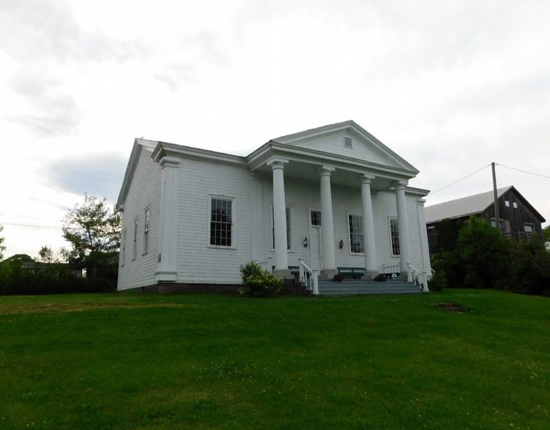
Queen's County Courthouse 1836
Constructed by local builder John Glass to plans furnished by John Cunningham, this impressive Neo-classical building served as the county seat of justice for over one hundred twenty-five years. . . . — — Map (db m286172) HM
On Front Street, on the right when traveling south.
Born here in 1818, Tilley was first elected M.L.A. for Saint
John in 1850 and subsequently served on the Executive
Council and as leader of the provincial government. A delegate to the Charlottetown, Québec and London Conferences,
he . . . — — Map (db m302723) HM
On Front Street, on the left when traveling north.
Sir Samuel Leonard Tilley (1818-1896), Father of Confederation, was
born and spent his boyhood in this house which had been bought by his
grandfather in 1805. Built in the 1780's by Dr. S. Stickles, the house is
representative of many . . . — — Map (db m302722) HM
On Rue Principale (Main Street) (New Brunswick Route 134) at Chemin Desherbiers (Desherbiers Road), on the right when traveling south on Rue Principale (Main Street).
Français:
Né à Saint-Louis-de-Kent et ordonné prêtre en 1870, Mgr Richard fut l'une des figures de proue de la renaissance acadienne. Il stimula la colonisation afin de centrer l'exode yeti les États-Unis, fonda des écoles, des . . . — — Map (db m139702) HM
On New Brunswick Route 134 just north of Chemin Lovers Lane, on the right when traveling north.
Français:
À l'automne 1767, les familles Gueguen, Arseneau, Hébert et Bourg reçoivent les premières concessions de terres accordées à des Acadiens après le Grand Dérangement.
En novembre, Cocagne devient la première communauté . . . — — Map (db m139701) HM
Near Champlain Street (New Brunswick Route 106) 0.1 kilometers east of Wheeler Boulevard, on the right when traveling east.
Français: Les Acadiens sont les premiers colons européens à s'établir à la baie de Fundy, au début du 17e siècle. Ils transforment le paysage en asséchant des marais salés et en construisant des levées et des aboiteaux pour créer . . . — — Map (db m150975) HM
Near Champlain Street (New Brunswick Route 106) 0.1 kilometers east of Wheeler Boulevard, on the right when traveling east.
English: The Grand Dérangement L’Acadie, established by France in 1604, was a strategically located and highly coveted colony. In 1713, it was handed over to England and renamed Nova Scotia. The foundation of Halifax, in 1749, . . . — — Map (db m150940) HM
On Couvent Way (County Route 475) close to Evangeline Street ( Route 134), on the right when traveling east.
English: Here, within sight of the farm where he was born and the river where he swam as a boy, stands a monument in honor of the memory and accomplishments of Buctouche’s most famous son Kenneth Colin Irving. Born March 14, 1899, he was one . . . — — Map (db m80581) HM
On Rue Évangéline (New Brunswick Route 134) at Chemin du Couvent (County Route 475), on the left when traveling south on Rue Évangéline.
English:
This stone marks the site where K.C. Irving built his first service station in 1924 and where he sold Irving Primrose gasoline and Ford cars.
Français:
Cette pierre marque l’endroit où K.C. Irving a . . . — — Map (db m139896) HM
Near Rue Centrale Street 0.5 kilometers north of Saint Thomas Street ( Route 925), on the left when traveling north.
[Français] Depuis sa construction, ce bâtiment a occupé une place toute spéciale dans le cœur des Acadiens, à titre de monument commémoratif, de maison d’enseignement et de foyer de rassemblement pour des activités . . . — — Map (db m269199) HM
Near Rue Centrale Street 0.5 kilometers north of Saint Thomas Street ( Route 925), on the left when traveling north.
[Français] Malgré les déportations des années 1750 et 1760, de nombreux Acadiens revinrent d'exil et d'autres quittèrent leur refuge pour se réinstaller sur leur terre natale. S'armant de courage et de détermination, . . . — — Map (db m269197) HM
Near Rue Centrale Street 0.5 kilometers north of Saint Thomas Street ( Route 925), on the left when traveling north.
[English]
The Monument-Lefebvre holds a special place in the hearts and minds of the Acadian people. Overlooking the scenic Memramcook Valley, the Monument-Lefebvre was built in 1896-97. This memorial is an . . . — — Map (db m269299) HM
English: From the bygone days of New Brunswick's "Golden Age of Sail", its once-prosperous commercial fishery, and its growing tourism and ecotourism industry, the Petitcodiac River continues to play an important role in the . . . — — Map (db m150992) HM
Near Assomption Boulevard 0.2 kilometers east of Westmorland Street, on the right when traveling east.
English: Historically, the Petitcodiac River was home to a large number of fish species. Both the rainbow smelt and Atlantic tomcod numbered in the hundreds of thousands. There were healthy populations of gaspereau, American eel, . . . — — Map (db m150985) HM
On Bendview Court just south of Main Street ( Route 106), on the left when traveling south.
In memory of the 1.5 million martyrs
of the Armenian Genocide
and
all victims of genocide
A la mémoire de 1,5 millions de martyrs
du génocide arménien
et
de toutes les victimes de génocide — — Map (db m106601) HM WM
Near Main Street (New Brunswick Route 106) 0.1 kilometers west of Wheeler Boulevard, on the right when traveling east.
English: The Settlers of the Township of Monckton reached their destination after 44 days at sea, on June 3, 1766. Captain Jonathan Hall guided the sloop along Pennsylvania's Schuylkill River to the New England coast, then entered . . . — — Map (db m151002) HM
On Downing Street north of Assomption Boulevard, on the right when traveling north.
English: The Provincial Bank Building (opposite) is located at the corner of Main and Downing. Commissioned in 1909 by the Provincial Bank of Canada to be its Maritime Provinces headquarters, this building was occupied by the bank . . . — — Map (db m150996) HM
On Main Street (New Brunswick Route 106) just east of Ruelle Oak Lane, on the right when traveling east.
English: Built in 1926, the Capitol Theatre was designed by Moncton architect René-Arthur Fréchet and features frescoes by Emmanuel Briffa. With its deep, opera-style stage, the theatre has accommodated both motion pictures and live . . . — — Map (db m150964) HM
On Downing Street at Assomption Boulevard, on the right when traveling north on Downing Street.
English: Downing Street is the namesake of Johanna Downing, a Moncton resident from 1840 until 1876. She and her husband, Peter McSweeney, moved from Ireland to Hillsborough, New Brunswick, in 1832. Peter later became a farmer, real . . . — — Map (db m150995) HM
On Queen Street just west of Church Street, on the right when traveling west.
On this site a house of worship was erected in 1857 destroyed by fire 1913 present building dedicated to the glory of God May 16, 1915 160th Anniversary June 8, 1988 Heritage Moncton Inc. — — Map (db m151005) HM
On Main Street (New Brunswick Route 106) at Bendview Court, on the right when traveling east on Main Street.
This part of "Le Coude" (The Bend) was in earlier times called Terre-Rouge. Three families from the Grand-Prée region first settled here:
Jean Babineau & Isabelle Breau, circa 1733,
followed by Joseph Breau & Isabelle Thibodeau
and Charles . . . — — Map (db m106603) HM
On Downing Street north of Assomption Boulevard, on the right when traveling north.
English: Downing Street was an important hub for many industries relying on various modes of transportation for the arrival and shipment of cargo and merchandise. Français: La rue Downing était une plaque tournante . . . — — Map (db m150998) HM
On Bendview Court just south of Main Street ( Route 106), on the left when traveling south.
The Moncton 100 Monument honours Joseph Salter, shipbuilder, entrepreneur and first mayor of the Township of Moncton in 1855.
Local entrepreneurs, whose names are inscribed on this monument, undertook funding of the project as their gift to . . . — — Map (db m106613) HM
Near Main Street (New Brunswick Route 106) 0.1 kilometers west of Wheeler Boulevard, on the right when traveling east.
English: 1 • This journey began in Europe where eight families, seven of German origin, and one of Welsh origin, set out to seek a new homeland. It ended here, on these muddy Banks of the Petitcodiac River, when the families of . . . — — Map (db m151001) HM
On Queen Street just west of Church Street, on the left when traveling west.
This plaque commemorates Methodism in Moncton 1781 Ministry of Methodist Preachers 1822 Circuit established 1828 Methodist Society formed 1847 First denominational church in Moncton, corner of Main and Wesley Streets 1877 . . . — — Map (db m151214) HM
On Downing Street just north of Assomption Boulevard, on the right when traveling north.
English: These maps and street directories of Moncton show businesses and homes once located on Downing Street. Français: Ces cartes et répertoires de Moncton montrent les entreprises et résidences autrefois situées . . . — — Map (db m150999) HM
Near Main Street (New Brunswick Route 106) 0.1 kilometers west of Wheeler Boulevard, on the right when traveling east.
English:
In honour of the permanent settlers of the Monckton township, the Stief, Lutz, Treitz, Jones, Sommers, Copple, Ricker and Wortman families who came up the Petitcodiac River from Pennsylvania and landed on the bank of this . . . — — Map (db m151000) HM
On Botsford Street (New Brunswick Route 134) north of Queen Street, on the right when traveling north.
First wooden church erected in 1872 Cornerstone present church laid 1888 100th anniversary of first celebrated mass November 1, 1991 November 1, 1891 — November 1, 1991 Heritage Moncton Incorporated — — Map (db m150993) HM
On Downing Street north of Assomption Boulevard, on the right when traveling north.
English: The Peter McSweeney Company Limited (700 Main) offered a special sale called the Red and Green Tag Campaign twice a year, when the tides allowed customers to arrive by ship in the morning to go shopping and return home in . . . — — Map (db m150997) HM
Near Main Street (New Brunswick Route 106) 0.1 kilometers west of Wheeler Boulevard, on the right when traveling east.
English: When they first arrived, the settlers lived together in small, rough cabins. But soon, each family built its own home, as stipulated in the Articles of Agreement. Initially, all livestock was housed in a communal shed. The . . . — — Map (db m151003) HM
Near Assomption Boulevard 0.2 kilometers east of Westmorland Street, on the right when traveling east.
English: Because of access to the Atlantic Ocean and an abundance of timber, communities along the Petitcodiac, like others in New Brunswick, flourished during the "Golden Age of Sail". It began as early as 1827, when Moncton was . . . — — Map (db m150981) HM
Near Main Street (New Brunswick Route 106) just west of Wheeler Boulevard, on the right when traveling east.
English: Powered by the high tides of the Bay of Fundy, the tidal bore has fascinated visitors and residents for generations. It was considered one of the top tidal phenomena in the world until the construction of a causeway in the . . . — — Map (db m150960) HM
On Westmorland Street just south of Main Street ( Route 106), on the right when traveling south.
Built in 1900 by John T. Hawke, Publisher and Editor of The Transcript Revitalized in 1990 by the Law Firm of Ellsworth Johnson & Partners Registered as a Historic Place on September 9, 1996 This commemorative plaque was erected by Ellsworth . . . — — Map (db m150994) HM
Near Main Street (New Brunswick Route 133) 0.7 kilometers east of Cornwall Road, on the right when traveling east.
English:
Edward R. McDonald was born in Pointe-du-Chêne, New Brunswick, in 1871. He was the son of Captain William McDonald and Catherine Costello McDonald. He was married to Miss Annie Gertrude Ryan and was the father of four . . . — — Map (db m142218) HM
On Main Street near Inglis Street, on the left when traveling east.
English:
Born in or near Shediac, Pascal Poirier (1852-1933), historian and first Acadian senator; Placide Gaudet (1850-1930), historian and genealogist; John Clarence Webster (1863-1950), historian, Professor, and eminent surgeon, all . . . — — Map (db m80578) HM
Near Main Street (New Brunswick Route 133) 0.7 kilometers east of Cornwall Road, on the right when traveling east.
English:
Daniel Lionel Hanington was born on 27 June 1835 in Shediac, New Brunswick, to Daniel Hanington, Sr. and Margaret Peters. He attended Mount Allison Academy, and then studied law under Charles Fisher in Fredericton. He was . . . — — Map (db m142004) HM
On Main Street (New Brunswick Route 106) just north of Woodlawn Road, on the right when traveling north.
English:400th anniversary celebration of the 1st Acadian settlement. Dedicated to those Acadians who were part of the history of the Village of Dorchester and area. Français:Fêtes du 400e anniversaire de . . . — — Map (db m193196) HM
On Cape Road (New Brunswick Route 935) just south of Main Street ( Route 106), on the left when traveling south.
English: One of New Brunswick’s oldest surviving stone buildings, the Bell Inn was constructed before 1820 of stone quarried on the site. It has filled both commercial and residential functions. Provincial Historic . . . — — Map (db m193200) HM
On Main Street (New Brunswick Route 106) just south of Cape Road (Woodlawn Road) (County Route 935), on the left when traveling south.
English: This Classical Revival house was built for Edward Barron Chandler (1800-1880) about 1831. A hipped slate roof tops the ashlar structure. Rustication on the first storey wall contrasts with the smooth face above. Triglyphs . . . — — Map (db m193181) HM
Near Woodlawn Road just east of Main Street ( Route 106), on the left when traveling east.
English: These marks bear testimony to the ceremony when his Worship Mayor Jerome Bear on behalf of Dorchester Village Council granted Freedom of the Village of Dorchester to the Correctional Service of Canada on July 26th 2015. . . . — — Map (db m193198) HM
Near Main Street (New Brunswick Route 106) just north of Penitentiary Road, on the right when traveling north.
The first Methodist Church in this area was built here in 1783, on land donated by John Weldon. Rebuilt after a fire in 1839, a larger church was built in 1882, now Dorchester United Church. The first burial in this cemetery was of John Weldon’s . . . — — Map (db m193199) HM
Near Woodlawn Road just east of Main Street ( Route 106), on the left when traveling east.
English: Born at Shediac, educated locally, and called to the bar in 1847, Smith represented Westmorland in the New Brunswick Legislature from 1851 to 1867. Minister without portfolio in the first Liberal government of the province . . . — — Map (db m193194) HM
On Main Street (New Brunswick Route 940) 0.2 kilometers south of Walker Road, on the left when traveling north.
The first Methodist chapel
in the Sackville area was
dedicated in July 1790 by
the Rev James Mann. It[']s
first trustees were
John Fawcett • William Fawcett
John Fawcett Jr • Andrew Wheldon
Robert Atkinson
The stone foundations . . . — — Map (db m106339) HM
On Main Street (New Brunswick Route 940) just south of Fawcett Avenue, on the right when traveling south.
A pump-house was constructed on this site in the fall of 1919 to house a large water pump driven by a 40HP electric motor. The pump was installed to boost the water pressure in the Town’s hydrants during times when water was required for fire . . . — — Map (db m106382) HM
On Main Street (New Brunswick Route 940) at Rectory Lane, on the right when traveling north on Main Street.
The rectory was constructed in the Queen Anne Revival style in 1880 on land given by J.F. Allison and Mary Allison Botsford. The design was prepared by R. C. Boxall and constructed by Mr. J. Teed of Dorchester. Great pains were taken with the . . . — — Map (db m106390) HM
On Bridge Street (New Brunswick Route 106) at Weldon Street, on the left when traveling east on Bridge Street.
A vial of sand taken from Juno Beach has been poured into
the header of this memorial to honor the 14,000 Canadians
who took part in the Battle of Normandy — — Map (db m106592) HM
On Bridge Street just east of Main Street, on the right when traveling east.
The Copp Block was built for A.B. Copp, lawyer, politician, Secretary of State and Senator. The ground floor has served as a law office ever since construction and Senator Copp maintained an office here from 1897 until his death in December of . . . — — Map (db m106472) HM
On Bridge Street (New Brunswick Route 106) just east of Centennial Park, on the right when traveling east.
In the early 1900's, this was the home and office of Dr. E.M. Copp, a medical doctor. His career began as a general practice and he delivered many a baby. After a residency in New York [C]ity, he became an eye, ear, nose and throat specialist. — — Map (db m106526) HM
On Main Street (New Brunswick Route 106) at Allison Avenue, on the right when traveling south on Main Street.
Erected by
the Town of Sackville
to commemorate
the designer
of the Canadian flag
George F. G. Stanley
C.C., C.D., K.StJ., D.Phil., LL.D.
Former Lieutenant-Governor of
New Brunswick, Professor, Historian,
Second World War . . . — — Map (db m106430) HM
On Bridge Street (New Brunswick Route 106) at Main Street ( Route 940), on the right when traveling west on Bridge Street.
Harold Geddes was a local landmark. Small in stature, he stood tall in this community.
Orphaned in the Halifax Explosion of 1917, he was adopted by Charles and Alice Geddes of Sackville.
On retirement from his job as a custodian at Mount . . . — — Map (db m106479) HM
On Bridge Street (New Brunswick Route 106) at Weldon Street, on the left when traveling east on Bridge Street.
This garden is named in honour of HMCS Sackville, a corvette that had a distinguished career during the Second World War. She was launched on May 15, 1941 in Saint John, New Brunswick and was christened by Mrs. J.E.W. Oland in the . . . — — Map (db m106595) HM WM
On Bridge Street (New Brunswick Route 106) just east of Centennial Park, on the right when traveling east.
Built by the Hon. William Crane, an early Sackville merchant, landowner, politician and partner of Charles Frederick Allison. The home was a wedding present for his daughter Ruth and Edward Cogswell and was known as Cogswell House. In 1895, it was . . . — — Map (db m106525) HM
On Main Street (New Brunswick Route 106) just south of Allison Avenue, on the left when traveling south.
Harris Miller had this two storey building constructed in 1913. It began as three store fronts with four apartments on the second floor.
Over time Harris Miller, Henry Berman, Arthur Sharpe and the Estabrooks brothers operated clothing and . . . — — Map (db m106426) HM
On Bridge Street (New Brunswick Route 106) just east of Centennial Park, on the left when traveling east.
Presbyterians worshipped in Middle Sackville from the 1840's and built a church there in 1871 which was used until the turn of the century when they began to meet in Sackville. The present structure was built as a two-storey hall and dedicated on . . . — — Map (db m106527) HM
On Main Street (New Brunswick Route 940), on the right when traveling north.
The construction of St. Paul's began in 1856, based on a model brought by the Rt. Rev. John Medley, First Bishop of Fredericton. Bishop Medley's interest in Gothic Revival architecture, recreating a medieval stone building in New Brunswick wood, . . . — — Map (db m106421) HM
On Main Street (New Brunswick Route 106) just south of Bridge Street/York Street, on the left when traveling north.
This building stands on land originally part of the Bowser Farm property purchased from Daniel Hawkins in 1777. In 1894 local merchant George E. Ford acquired a five acre lot, on which he constructed this block as a department store in three . . . — — Map (db m106470) HM
On Bridge Street (New Brunswick Route 106) just east of Main Street, on the right when traveling east.
Built by Henry Fawcett and A.B. Copp in 1900, this block was the home of the Sackville Book Store, owned by W.R. Goodwin until 1906, and then also a drugstore operated by W.R. Rodd, a druggist and optician.
For a time, it was known as the . . . — — Map (db m106473) HM
On Bridge Street (New Brunswick Route 106) at Weldon Street, on the left when traveling east on Bridge Street.
The Royal Canadian Air Force has stood on guard for Canada since 1924. Over three hundred and twenty five Sackville area residents and students of Mount Allison University have served in the R.C.A.F. both here and abroad from the First World War . . . — — Map (db m106550) HM
On Bridge Street (New Brunswick Route 109) just east of Main Street ( Route 940), on the left when traveling east.
Constructed of local stone, this Romanesque Revival building is closely associated with Josiah Wood, a prominent Westmoreland County businessman and politician. The upper-level theatre is a unique design feature.
Cet édifice en pierre locale, de . . . — — Map (db m106521) HM
On Main Street (New Brunswick Route 940) at Bridge Street/York Street, on the right when traveling south on Main Street.
Once the Amasa Killam property, granted in 1765, this site has contained a number of commercial stores including the Crane-Allison store. The intersection has long been called Crane's Corner. Other stores operating at this site were Smith & . . . — — Map (db m106476) HM
On Bridge Street at Weldon Street, on the left when traveling east on Bridge Street.
Their Name Liveth Forevermore
1914 - 1918
Roland Beal • Frank Milner • Arthur Bourque
George Bickerton • Ralph Crossman • Alpheus Crossman
Stanley Crawford • Arthur DeVarenne • Henry Dixon
Virgile Gaudet • Winfred Hicks • Walter Knapp . . . — — Map (db m106556) WM