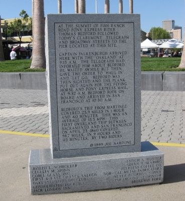
Dedicated April 23, 1999
Jack London Square
By Port of Oakland, William Campbell Family, Dreyers Grand Ice Cream, Alameda/Oakland Ferry Service, Waterfront Plaza Hotel & Jacks, Sportsman's Hall - Pollock Pines Pony Express Home . . . — — Map (db m19017) HM
On Old Pony Express Way (California Route 88) east of Route 89, on the right when traveling east.
During the initial five weeks of its operation in 1860, an important remount station of the famous Pony Express was located a few feet from here at Cary’s Barn.
This monument erected by the Historical Society of Alpine County.
National . . . — — Map (db m143520) HM
On Old Pony Express Way (California Route 88) east of Route 89, on the left when traveling east.
Historic Woodfords Station, the Eastern Sierra gateway to the goldfields of California, way station of the famed Pony Express, and entrance to Carson Pass on the Emigrant Trail to the Sacramento Valley. Beginning in 1849 with the building of the . . . — — Map (db m195369) HM
In 1860-1861 Pony Express riders stopped in Lafayette 19 times to change horses en route to San Francisco from St. Joseph, Missouri
Lafayette Historical Society
1992 — — Map (db m24461) HM
On Mt. Diablo Boulevard at Morago Road, on the right when traveling east on Mt. Diablo Boulevard.
Dedicated April 23, 1998
Lafayette House
Added Station
By
Diablo Foods
Better Homes Realty - Lafayette
Diamond K. Supply, Ltd.
Lafayette Chamber of Commerce
Lafayette Historical Society
Pony Express Trail Association
{reverse . . . — — Map (db m24916) HM
On Joe DiMaggio Jr., Drive at Ferry Street, on the left when traveling east on Joe DiMaggio Jr., Drive.
Founded by Dr. Robert Semple in 1847, the Martinez-Benicia ferry was the first established and longest operating ferry service in the S.F. Bay Area. In 1850 Oliver Coffin took over the operation and with his brothers purchased a new ferryboat, the . . . — — Map (db m27645) HM
On Main Street at Ferry Street, on the right when traveling east on Main Street.
Dedicated April 23, 2000
Morgan House
Pony Express Route
Apr. 23, 1860 - Sep. 8, 1861
Home Station
Apr. 16, 1869 - Sep.8, 1861
By
James Stretesky
Supervisor Gayle B. Uilkema
Martinez Area Chamber of Commerce
Pony Express Trail . . . — — Map (db m24369) HM
Near Camino Pablo west of Brookwood Road, on the right when traveling north.
A nearby plaque
commemorates the
passage in 1860-1861
of Pony Express riders
from Sacramento to
the San Francisco
terminus. They usually
rode river steamers,
but 20 times the Pony
Express took an
overland route as the
steamers did not . . . — — Map (db m142217) HM
Pony Express Trail
This plaque commemorates the passage in 1860 and 1861 of the Pony Express riders from Sacramento to San Francisco through what is now Orinda.
Sponsored by the City of Orinda's Historical Landmark Committee and the Pony . . . — — Map (db m29913) HM
On Pleasant Valley Road (State Highway 49), on the right when traveling west.
This town, settled in 1848, derived its name from its crystal clear springs. Among the richest in this vicinity its diggings produced a 25 pound nugget, one of the largest in El Dorado County. Its most thriving period was in 1851. Later it became a . . . — — Map (db m10936) HM
On Pleasant Valley Road, on the right when traveling east.
Trading post, emigrant stop, and mining camp of the 1850’s. This became one of the remount stations of the Central Overland Pony Express. Here at the Nevada House on April 13, 1860, pony rider William (Sam) Hamilton changed horses while carrying . . . — — Map (db m11571) HM
On PG&E-Clarksville Sub-Station Road, on the right when traveling west.
At this site on the old Clarksville-White Rock Emigrant Road was Mormon Tavern. Constructed in 1849, this popular stage stop was enlarged and operated by Franklin Winchell in 1851. It became a remount station of the Central Overland Pony Express and . . . — — Map (db m12056) HM
On U.S. 50 near Ice House Road, on the right when traveling west. Reported missing.
This was the site of a change station of the Pioneer Stage Company in the 1850’s and 1860’s. During 1860-1861, the Central Overland Pony Express maintained here the first pony remount station east of Sportsman’s Hall. — — Map (db m57977) HM
On Interstate 50, on the left when traveling east.
This was the site of Webster's Sugar Loaf House, well-known stopping place during the Comstock rush. Beginning in April 1860, it was used as a remount station of the Central Overland Pony Express. In 1861 it became a horse change station for . . . — — Map (db m14177) HM
On Lincoln Highway (U.S. 50) west of Apache Avenue, on the left when traveling west.
Send me men to match my mountains.
These are words a great poet said speaking for the brave young nation that needed strong and brave men’s aid.
In memory of
John (Snowshoe) Thompson
who, for twenty successive winters, 1856-1876, . . . — — Map (db m434) HM
On Lincoln Highway (U.S. 50) west of Apache Avenue, on the left when traveling west.
(back) The Hawley Grade from April 3, 1860 to November 17, 1860 was used by the Pony Express. On November 18, 1860 the new toll road down Johnson Pass (Echo Summit), today’s Old Meyers Grade, was opened to horse traffic and was now used by . . . — — Map (db m435) HM
On US Highway 50 (U.S. 50) west of Pioneer Trail, on the left when traveling west.
This was the site of the most eastern remount station of the Central Overland Pony Express in California. Established as a trading post in 1851 by Martin Smith, it became a popular hostelry and stage-stop operated by Ephraim “Yank” Clement on the . . . — — Map (db m433) HM
On Main Street at Sacramento Street, on the right when traveling east on Main Street.
Gold Rush town and Western Terminus of the Placerville – Carson Road to the Comstock. Placerville was a relay station of the Central Overland Pony Express, April 4, 1860 – June 30, 1861. Here on April 4, 1860 the first east-bound pony . . . — — Map (db m57973) HM
On Pony Express Trail east of Exit 57 (U.S. 50), on the right when traveling east.
California’s only Home Station where riders changed on the Pony Express trail. Here, at 8:01 A.M. on April 4, 1860, Sam Hamilton, first eastbound rider, was relieved by Warren Upson who carried the initial mail over the then storm swept Sierras.
. . . — — Map (db m613) HM
On Pony Express Trail east of Exit 57 (U.S. 50), on the right when traveling east.
This was the site of Sportsman’s Hall, also known as Twelve-Mile House. The hotel operated in the late 1850’s and 1860’s by John and James Blair, a stopping place for stages and teams of the comstock. It became a relay station of the Central . . . — — Map (db m609) HM
On Durock Road south of U.S. 50, on the right when traveling west.
Dedicated July 1, 2000
Du Roc House
Added Station
July 1, 1861 – Nov. 20, 1861
by
PW Pipe
James Stretesky
Norman & Ann Root
County of El Dorado
American Suzuki Motor Corporation
Pony Express Trail . . . — — Map (db m50321) HM
On Green Valley Road, on the left when traveling east.
This was the site of a popular roadhouse, where the ponies of the Central Overland Pony Express were changed during July 1, 1860 to June 30, 1861. From here the route of the pony riders continued westward to Folsom and eastward through Rescue, Dry . . . — — Map (db m10442) HM
On Highway 50 (U.S. 50) west of Strawberry Lane, on the right when traveling west.
This popular resort and stopping place for stages and teams of the Comstock, established by Swift and Watson in 1856, became a remount station of the Central Overland Pony Express on April 4, 1860. Here on that date division superintendent Bolivar . . . — — Map (db m436) HM
On Sutter Street at Wool Street, on the right when traveling east on Sutter Street.
Gold Rush and Railroad town Folsom became the Western Terminus of the Central Overland Pony Express on July 1, 1860. The express mail had been run by pony to and from Sacramento. Beginning on July 1, 1860, the
Sacramento Valley Railroad carried it . . . — — Map (db m5090) HM
On Kilgore Road, on the left when traveling north.
Organized March 1874
Dedicated October 1882
Presented by Native Daughters of the Golden West
San Juan Parol #315
Rededicated 5-15-98 — — Map (db m2033) HM
On White Rock Road at Gold Valley Drive, on the right when traveling east on White Rock Road.
Owned and operated from 1857 as a stage station by Henry F. W. Deterding. This was the site of the second remount station of the Central Overland Pony Express during March-July 1860. Here on April 4, 1860, Sam (Bill) Hamilton with the first eastward . . . — — Map (db m2034) HM
Near Mills Station Road west of Mather Field Road, on the right when traveling west.
The famed Pony Express was an overland mail service delivering messages, newspapers, mail, and small packages from St. Joseph, Missouri, across the Great Plains, over the Rocky Mountains and the Sierra Nevada to Sacramento by horseback, using a . . . — — Map (db m214501) HM
On J Street at 4th Street, on the right when traveling east on J Street.
[Front of Marker]
ST.GEORGE HOTEL
Dedicated March 19, 2005
SACRAMENTO
By
James Streetsky
First Northern Bank
The Firehouse Restaurant
Rotary Club of Sacramento
Burnett & Sons Planing Mill
and Lumber Co. – Since . . . — — Map (db m14810) HM
Departing at 2:45 A.M. from the Alta Telegraph Co. in Sacramento, Pony Rider Sam (Bill) Hamilton carried the first mail eastward of the Central Overland Pony Express on April 4, 1860. Here quickly changing ponies he sped on to the next stop at . . . — — Map (db m261278) HM
On 2nd Street south of I Street, on the left when traveling south.
This structure, erected in 1852-53, was occupied during the 1850’s by the B.F. Hastings Bank, Wells Fargo and Co., various state officials, Sacramento Valley Railroad, and the Alta Telegraph Co. during April 1860 - May 1861. The Alta Telegraph . . . — — Map (db m11388) HM
Founded in December 1848 by John A. Sutter, Jr., Sacramento was an outgrowth of Sutter’s Fort established by his father, Captain John A. Sutter, in 1839. State Capital since 1854, it was a major distribution point during the Gold Rush. A . . . — — Map (db m11486) HM
Dedicated April 13, 2000
Sacramento
by
James Stretesky
George E. Kuchler Family
Rotary Club of Sacramento
Burnett & Sons Planing Mill and Lumber Co – Since 1869
Sacramento Traditional Jazz Society
Sacramento Metro Chamber of . . . — — Map (db m15702) HM
On 2nd Street at J Street, on the left when traveling south on 2nd Street.
This statue commemorates the glory of The Pony Express, which started here at 2:45 a.m. on April 4, 1860, when Sam Hamilton galloped into a blinding rainstorm on the first lap of the 1,966-mile trip to St. Joseph, Missouri. During its 18-month . . . — — Map (db m11326) HM
1860 · 1861 1960 · 1961
120 celebrated riders rode 650,000 miles with only one rider killed by Indians, one schedule not completed and one mail pouch lost. — — Map (db m11348) HM
On R Street at 3rd Street, on the left when traveling west on R Street.
The Sacramento Valley Railroad running from Sacramento to Folsom, was begun at this site on February 12, 1855. Here, at Third and R Streets, was located the Sacramento passenger terminal. The turntable and freight depot were at Third and Front . . . — — Map (db m16056) HM
On Clay Street at Montgomery Street on Clay Street.
The first Pony Express rider to reach San Francisco on the final relay carrying mail from St. Joseph, Missouri to California, arrived in this city Apr. 14, 1860 aboard the River Str. ‘Antelope’. Led by a band and several engine companies, a . . . — — Map (db m268110) HM
On Montgomery Street at Merchant Street, on the right when traveling south on Montgomery Street.
This was the site of the western business headquarters of Russell, Majors, and Waddell -- founders, owners, and operators of the Pony Express, 1860-1861. The firm's main office was in Leavenworth, Kansas. W.W. Finney was the western representative . . . — — Map (db m33775) HM
Near Montgomery Street near Washington Street, on the left when traveling north.
This, San Francisco’s first fireproof building erected in 1853 by Henry Wager Helleck, was the headquarters for many outstanding lawyers, financiers, writers, actors and artists. James King of William, editor of the Bulletin, died here . . . — — Map (db m143443) HM
On The Embarcadero at Broadway Street, on the right when traveling south on The Embarcadero.
Nearby was the location of the Broadway Wharf. The wharf extended from Broadway and Davis Streets east to this location. All of the Pony Express mail that was delivered to and from San Francisco used this wharf. The Pony Express ran from April 3, . . . — — Map (db m63717) HM
On First Street, on the right when traveling south.
William Hamilton, the first Pony Express rider to reach Benicia on the final relay. Carrying the mail from St. Joseph, Missouri to California. Arrived in this city April 23, 1860, at 7 a.m. Thomas J. Bedford, a young Benician, took the mochila by . . . — — Map (db m16325) HM
On First Street, on the right when traveling south.
[Front of Marker:]
Dedicated April 23, 2000
by
James Stretesky
Benicia Historical Society
Benicia (N.S.G.W.) Native Sons
Richard & Veronica Tipton
Benicia Camel Barn Museum
Exxon Mobile, Benicia Refinery
Benicia Chamber of . . . — — Map (db m16327) HM
On Silveyville Road at Schroeder Road, on the left when traveling west on Silveyville Road.
Dedicated April 23, 1998
Halfway House
Added Station
Apr. 23, 1860 - Sep. 8, 1861
By
Sidney & Diane Schroeder Family
Ron Dupratt Family
John & Patty Greiner Family
Dixon Historical Society
American Legion Dixon Post #208 . . . — — Map (db m29940) HM
On Suisun Valley Road at Rockville Road on Suisun Valley Road.
{Obverse:}
Dedicated April 23, 1998
Rockville House
Added Station
Apr. 3, 1860 - Sep. 8, 1861
By
Rockville Inn
Floyd & Lillian Hembree
Joseph C. Wolfskill Family
Ramirez Towing - Rudy's Auto Body
Solano #39 (NGSW) . . . — — Map (db m30619) HM
On Mankas Corner Road at Clayton Road on Mankas Corner Road.
This site was originally constructed in 1860 as the Suisun Valley General Mercantile & original Pony Express station.
The Vezer Family provides this facility for the enjoyment of the families of this wonderful valley and gives special . . . — — Map (db m25058) HM
[Front of Marker]
Dedicated April 3, 1997
RIO VISTA
by
James Stretesky
The Dutra Group
Barrier Systems, Inc.
Rio Vista Chamber of Commerce
Pony Express Trail Association
Sponsors are listed on bottom of base . . . — — Map (db m18276) HM
On Merchant Street at Main Street, on the right when traveling north on Merchant Street.
[Front of Marker:]
IN SEARCH OF THE PONY EXPRESS
STATION MARKER
Dedicated April 23, 1997
GILLESPIE’S STORE
Added Station
Apr 23, 1860 – Sep 8, 1861
by
Dave & Buff Fleming
American Honda Motor Co., Inc.
Vacaville . . . — — Map (db m16833) HM
Dedicated April 23, 1999
SOLANO HOUSE
Added Station
Apr. 23, 1860 - Sept. 8 1861
By
First Northern Bank
William & Linda Bernheim
The Rotary Clubs of Davis
UC Davis - Cal Aggie Alumni Association
Davis Enterprise - McNaughton . . . — — Map (db m24606) HM
Dedicated April 23, 2000
WEST SACRAMENTO
by
James Stretesky
First Northern Bank
Daniel F. Ramos Family
Frank C. Ramos Family
Dr. & Mrs. James O. Farley
West Sacramento Land Company
West Sacramento Chamber of Commerce
Pony Express Trail . . . — — Map (db m15708) HM
Near County Road 28 0.2 miles west of U.S. 385, on the left when traveling west.
(left panel) The Pony Express route was used for a little more than 19 months from April 3, 1860 to November 20, 1861.
Those known and verified riders of the 1860-1861 Pony Express that used “Overland City” (first Julesburg) as . . . — — Map (db m130331) HM
The first Pony Express trip between St. Joseph and San Francisco was 1943 miles. This first trip took 10 days. The Pony Express operated from April 3, 1860 to November 20, 1861. The trail was located 1100 feet North and Overland City was 6 miles . . . — — Map (db m47328) HM
On Saunders Avenue (U.S. 138) at Main Street, on the left when traveling west on Saunders Avenue.
350 rods southeast of this site is the famous and hazardous Upper California Crossing of the South Platte River which was used by the intrepid riders of the Pony Express in 1860-1861. Ovid was incorporated at this site in 1925.
Erected in . . . — — Map (db m110329) HM
On Main Street at 3rd Street, on the left when traveling east on Main Street.
On September 14, 1861 the "Central Overland California and Pike's Peak Express Co." who were the original owners and operators of the Pony Express moved their offices from the Patee House in St. Joseph, Missouri to here at the "Massasoit House." It . . . — — Map (db m44626) HM
Near Last Chance Road (Kansas Route 136) south of Doniphan Street, on the right when traveling south.
The Pony Express, the nation's first coast-to-coast express mail route, began as a publicity stunt for a million-dollar government contract by carrying mail from St. Joseph, Missouri to California in under 10 days. At the time, there were no . . . — — Map (db m252114) HM
On U.S. 36 near Ottumwa Road, on the left when traveling west.
In Search of the Pony Express ★ Station Marker ★
A little over a quarter of a mile to the southwest was a Pony Express Station called Troy. This was due to its close proximity to the town of Troy, Kansas. It was owned and . . . — — Map (db m47990) HM
On Delaware Street at 4th Street, on the left when traveling east on Delaware Street.
Before you stands the manufacturer's bank building; once headquarters for the freighting firm of Russell, Majors and Waddell. Fort Leavenworth's strategic location made it the logical logistical supply center to support the U.S. Army throughout the . . . — — Map (db m46713) HM
On 4th Street (U.S. 73) at Delaware Street, on the left when traveling north on 4th Street.
In the years 1855-1861 this firm was a major factor in the settlement of the West. Using thousands of teams, and both wagons and stagecoaches, it hauled supplies and passengers to Army posts and settlements west of Fort Leavenworth. Members of the . . . — — Map (db m46720) HM
On 21st Road 0.8 miles north of Granite Road, on the right when traveling north.
We spanned the prairie to Guittard's Station, on the far side of a shady, well-wooded creek, the Vermillion... For dinner...the ham and eggs, and hot rolls and coffee were fresh and good, and although drought had killed the salad, we had . . . — — Map (db m77972) HM
Begun in 1858, the Hollenberg Ranch, four miles north and one mile east of here, served as a stop on the Oregon-California Trail until the late 1860s. Gerat and Sophia Hollenberg, German emigrants, sold food and other supplies, lodging, and draft . . . — — Map (db m228348) HM
On Broadway at 8th Street, on the right when traveling east on Broadway.
In 1859, A.G. Barrett built the "Barrett Hotel." It was located here on the corner of Eighth and Broadway. He built it of native lumber made at his sawmill on the Black Vermillion River.
This was one of the largest hotels on the Overland Route . . . — — Map (db m48596) HM
On 8th Street near Elm Street, on the left when traveling south.
This barn, a Pony Express Station of 1860-61, stands on the original site. Here courageous Pony Express Riders changed mounts as they carried the Overland Mail through 1966 miles of territory, now eight states.
Russell, Majors, Waddell . . . — — Map (db m48631) HM
On South 10th Street, on the right when traveling north.
St. Joseph, MO. to Sacramento, CA. This fast-relay mail express, the only major trail solely used for communications, ran from April 1860 to October 1861. William Russell, Alexander Majors and William Waddell organized the Pony Express as a key . . . — — Map (db m253389) HM
On Main Street at 4th Street, on the left when traveling west on Main Street.
Captain John E. Smith was Seneca's first entrepreneur. In 1858 he built a simple hotel and tavern on this site. He also built a wooden bridge over the Nemaha River that bypassed the risky ford crossing two miles north at Richmond. These . . . — — Map (db m63795) HM
Wagons bound for Oregon and California left Independence starting in the
1840s and developed a trail to this location. Others started across the prairie from St. Joseph, and Fort Leavenworth. All of that traffic merged here at the junction of the . . . — — Map (db m253325) HM
Near 23rd Road (Highway 243) west of Big Bear Road, on the right when traveling west.
Built in 1857 as a ranch house, it is the only remaining unaltered station still standing in its original location. Erected by the Kansas State Historical Society. National Pony Express Centennial Association Dwight D. Eisenhower – Chairman . . . — — Map (db m246094) HM
On 23rd Road (State Highway 243) near Big Bear Road, on the left when traveling east.
This building, constructed in 1857 by G.H. Hollenberg on his ranch here on the Oregon Trail, was a station on the Pony Express route in 1860-1861. It is believed to be the only such station which has remained unaltered on its original site. — — Map (db m53293) HM
Hollenberg Station and Transportation
By the time Hollenberg Station was begun in 1857 or 1858, Gerat Hollenberg
already had years of experience in operating at road ranch on the Oregon-California Trail. A native of Germany, he had been drawn . . . — — Map (db m253085) HM
Hollenberg's Land- Gerat Hollenberg acquired 160 acres of land in 1857 or 1858. He bought it with a land warrant given by the United States government to a veteran of the War of 1812.
1. Hollenberg Station - The building also was known as . . . — — Map (db m253083) HM
Transportation is the movement of people or goods from one location to another. Long before the Europeans first came to this area in the 1500s, the native peoples were engaged in transportation. On foot they followed trails that had been cut by . . . — — Map (db m253088) HM
On Francis Street at 5th Strret, on the left when traveling east on Francis Street.
Robert Washington Donnell, one of the first settlers of the Platte Purchase, was instrumental in organizing the Bank of the State of Missouri and securing St. Joseph's position as the eastern terminus of the Pony Express. — — Map (db m66385) HM
On Penn Street at 12th Street, on the right when traveling east on Penn Street.
The Patee House was the Pony Express Company's Eastern Headquarters from April 3, 1860 to September 13, 1861. The company's official name was "The Central Overland California and Pike's Peak Express Company."
John Patee built the hotel from . . . — — Map (db m47398) HM
On Penn Street at 12th Street, on the right when traveling east on Penn Street.
Patee House – 1858
In this National Historic Landmark were located the offices of the Pony Express, founded by Russell, Majors & Waddell; the Hannibal & St. Joseph Railroad and the Civil War offices of the U.S. Provost Marshall. [sic] . . . — — Map (db m47444) HM
On 3rd Street at Felix Street, on the right when traveling south on 3rd Street.
On April 3, 1860 the eastern Pony Express mail arrived by train and it was late. To save time the Pony Express Company which was located in the Patee House at 12th and Penn Streets had the mail taken directly to the post office. The post office . . . — — Map (db m47480) HM
On Penn Street west of South 10th Street, on the left when traveling west.
1,996 miles in 10 days.
A daring horseback relay mail service connects the nation.
The Vision of the Pony Express
In January 1860. William H. Russell, Alexander Majors, and William B. Waddell, right, (partners in the freighting firm . . . — — Map (db m122600) HM
Renowned city of the Pony Express, St. Joseph was first settled as a trading post for the American Fur Company by Joseph Robidoux, 1826. Later he acquired the site and laid out a town in 1843.
St. Joseph became an outfitting point for . . . — — Map (db m4989) HM
On April 3, 1860, the Pony Express started from this neighborhood on its historic run to the West. Eight months after the Pony Express joined East and West, the country split North to South when South Carolina seceded. Missouri, including St. . . . — — Map (db m48063) HM
On Penn Street near South 10th Street, on the right when traveling west.
This monument erected by the
Daughters of the American Revolution
and
The City of St. Joseph
marks the place where the first
Pony Express started on April 3, 1860 — — Map (db m47492) HM
On this site, April 3, 1860, a ferry carrying a horse and rider crossed the Missouri River to start a 10 day journey of 1,966 miles to deliver mail to Sacramento, California.
The race against time, elements and a hostile land captured the spirit . . . — — Map (db m47470) HM
The National Significance of the Pony Express
The Pony Express ran from April 3, 1860, until the transcontinental telegraph was completed in October, 1861. The Pony Express proved that the Central Route to California could be traveled all . . . — — Map (db m79289) HM
He was a member of the firm of
Russell, Majors and Waddell,
founders, owners and operators
of the Pony Express.
This marks his grave.
The Pony Express
1860-1861 • 1960-1961 — — Map (db m63030) HM
On Main Street at 10th Street, on the right when traveling east on Main Street.
Northwest across this intersection is the original site of the Home Office of Russell, Majors and Waddell, owners and operators of the Pony Express. Though operating headquarters was at Leavenworth, Kansas, and the Eastern Terminus at St. Joseph, . . . — — Map (db m90906) HM
Some might say the idea for the Pony Express arose from a bad case of saddle sores. In 1849, W.M. Gwin, a senator from the new state of California, was making his way on horseback from San Francisco to Washington City. He and his companion, Mr. . . . — — Map (db m43179) HM
On American Legion Memorial Highway (U.S. 281) at West Saddlehorn Road, on the right when traveling south on American Legion Memorial Highway.
Oregon TrailMarked by the State of Nebraska and Niobrara Chapter Daughters of American Revolution Hastings Nebraska 1912————— Pony Express Russell Majors Waddell Founders Owners Operators St. Joseph — Sacramento . . . — — Map (db m287697) HM
On Grand Army of the Republic Highway (U.S. 34) 0.3 miles west of South Roseland Avenue, on the right when traveling west.
The Pony Express mail service on horseback operated from April 1860 until October 1861. The route went through 6 relay stations in Adams County for 30 miles along the Oregon Trail. Oregon Trail & Pony Express Route Sand Hill • Summit • Muddy . . . — — Map (db m287814) HM
Erected on the Oregon Trail, four miles east of Fort McPherson, Lincoln County, Nebraska, and used as fur trading post and ranch house. 1860 – 61 Used as Pony Express Station. 1862 – 1931 Used as Overland Trail Stage Station, dwelling, . . . — — Map (db m86773) HM
This old station once stood on the upper 96 Ranch west of here and south of the Platte River, on the original Pony Express route. It was moved and restored by Gothenburg Post No. 64, American Legion. Erected by the Gothenburg Chamber of . . . — — Map (db m86775) HM
[Pony Express medallion on top]
1860-61
South Platte Station
1.5 mi. directly south
Erected to the intrepid riders and operators 1932 by Deuel Co. — — Map (db m51252) HM
On Pine Street at West Second Street on Pine Street.
[Map of the Pony Express route]
From April 1860 until October 1861 the famed Pony Express riders passed along the south side of the Plate River south of Big Springs. Diamond Springs station was to the southeast. Frontz and Julesburg stations were . . . — — Map (db m51247) HM
On State Highway 25A at County Route 165, on the right when traveling north on State Highway 25A.
Here is the valley of Lodgepole Creek through which passed historic trails, telegraph lines, and railroads. The famed Pony Express followed the valley in 1860-61. "Nine Mile" Pony Express station was located just southeast of present Chappell; "Pole . . . — — Map (db m223445) HM
On Gold Rush Byway (U.S. 385), on the left when traveling north.
This marker has text on both sides
Dedicated October 4, 2003
Hughes’ Ranch
Added Station
July 1, 1861 - Nov. 20. 1861
by
Deuel County
Historical Society
James Stretesky
Sterling Monument Company
Pony . . . — — Map (db m79441) HM
Near 5th Street just west of E Street (568th Avenue), on the left when traveling west.
These were the four Pony Express Stations in Jefferson County. Big Sandy Station • Whiskey Run • Rock Creek Station • Otoe Station Rock Creek Station was the site where Wild Bill Hickok shot and killed David McCanles, July 12, 1861. Russell, . . . — — Map (db m177362) HM