3998 entries match your criteria. The first 100 are listed. Next 100 ⊳
National Register of Historic Places (NRHP) Historical Markers
This is a collection of buildings and places listed on the National Register of Historic Places (NRHP) that is administered by the U.S. Department of the Interior. This series showcases America’s notable historical and archeological resources.
On North Eufaula Avenue (U.S. 431) 0.1 miles north of Broad Street, in the median.
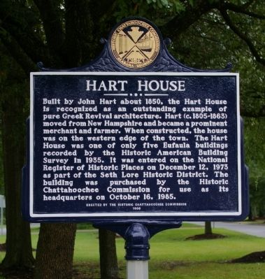
Built by John Hart about 1850, the Hart House is recognized as an outstanding example of pure Greek Revival architecture. Hart (c. 1805-1863) moved from New Hampshire and became a prominent merchant and farmer. When constructed, the house was on the . . . — — Map (db m48376) HM
On Parmer Street at Oglesby Street, on the right when traveling east on Parmer Street.
Butler Chapel African Methodist Episcopal Zion Church was founded in 1867
as an affiliate of the African Methodist Episcopal Zion Church. The church
is named for the first pastor, Rev. Lewis Butler, who donated the land where
the church now . . . — — Map (db m268663) HM
Near County Road 267 0.8 miles north of County Road 216, on the left when traveling north.
The Rosenwald School program was a collaboration
between educator Booker T. Washington and Sears
CEO Julius Rosenwald to improve educational
opportunities for African American children in
the rural South during the early 1900's. The
Rosenwald . . . — — Map (db m238815) HM
On U.S. Highway 84 (U.S. 84) 1.9 miles west of Lena Landegger Highway (County Road 39), on the right when traveling west.
This 4000 acre complex has been recognized for its contribution to our understanding of the history of Monroe County and the State of Alabama. Originally developed as a cotton plantation during the Antebellum period, this farm has been in continuous . . . — — Map (db m80345) HM
On East 4th Street at North Broad Street, on the right when traveling east on East 4th Street.
First Presbyterian Church was organized April 13, 1824, by Scots-Irish settlers. The sanctuary, erected in 1827, is the oldest in continuous use in Alabama. Its Georgian Gothic style remains essentially unchanged. The brick walls are laid in . . . — — Map (db m40429) HM
On Historical Central Street at Tisdale Street, on the right when traveling east on Historical Central Street.
Andalusia becomes the County Seat
The first county seat on the banks south of the falls of the
Conecuh River was "Covington Courthouse," sited soon after the
County was created in 1821. In 1826, when John Devereux was
postmaster, the name . . . — — Map (db m283903) HM
Near County Road 1043 west of County Road 1117, on the right when traveling north.
This 270 foot bridge was constructed in 1904, destroyed by a flood in 1921 and rebuilt the following year. The only remaining covered bridge in Cullman County, it was restored by the Cullman County Commission in 1975 as an American Revolution . . . — — Map (db m33833) HM
On Tremont Street, on the right when traveling south.
This was the residence of John Tyler Morgan (1824-1907), one of Alabama’s most honored political and military leaders. Constructed in 1859 by Thomas R. Wetmore, it was purchased by Morgan in 1865, and served for many years as his principal . . . — — Map (db m295588) HM
On Main Street 0.1 miles south of Alabama Route 14, on the right when traveling north.
This notable Greek Revival structure was completed in the late 1840's on land donated by Eli Robinson. The congregation was established 1828-1830 and the first church, built of logs, was located c. 1 mile east of here. Charter members were: Rev. . . . — — Map (db m71178) HM
On North St. Andrews Street, on the left when traveling north.
Listed on the National Register of Historic Places by the Department of the Interior, December 16, 1977, through the efforts of the Dothan Landmarks Foundation, Incorporated.
Constructed in 1915, this three-story masonry structure remains . . . — — Map (db m83780) HM
Entered on the National Register
of Historic Places
December 31, 1974
Federal Building
U.S. Courthouse
Dothan, Alabama
James Knox Taylor Architect 1909
This property significantly contributes to the Nation's Cultural Heritage . . . — — Map (db m83781) HM
On 7th Avenue North west of 24th Street North, on the right when traveling west.
Built 1923, 2316 7th Ave N.
Phillips High School was the flagship school in the center of Birmingham. It was named for John Herbert Phillips, the city's highly-esteemed first school superintendent, who served from 1883 until his death in . . . — — Map (db m187704) HM
On East Ervine Avenue at North Court Street, on the right when traveling west on East Ervine Avenue.
George Washington Foster, planter, built this Greek Revival Mansion. An Act of the legislature was required to close Court Street, In fall of 1864 it was headquarters of Nathan B. Forrest, General, CSA. Foster's daughter, Sarah Independence McDonald . . . — — Map (db m28868) HM
Near Riverview Drive at Grove Street, on the right when traveling east.
Constructed 1940 and 1948 Restored 1999 to 2002 Frank Lloyd Wright, Architect City of Florence William D. Jordan, Mayor Florence City Council Members Sam Pendleton, Jr., President • William M. Coussons • Tyndal Davis • Bobby . . . — — Map (db m288895) HM
On Avenue A just south of South 7th Street, on the left when traveling south.
Entered on the National Register of Historic Places November 18, 1976 George W. Andrews Federal Building U. S. Courthouse Opelika, Alabama James A. Wetmore Architect 1915 This property significantly contributes to the nation’s . . . — — Map (db m296572) HM
On South 9th Street south of Avenue A, on the right when traveling south.
Lee County Courthouse
Lee County was created from portions of Russell,
Macon, Chambers and Tallapoosa Counties by act of
the Alabama Legislature approved December 5, 1866.
Lee County's first election was held January 21, 1867.
An . . . — — Map (db m297059) HM
On Maysville Road Northeast north of Humes Avenue Northeast, on the right when traveling north.
George Gilliam Steele, one of Huntsville's preeminent architects, designed and built Oak Place as his country residence circa 1840 on 320 acres.
An outstanding example of Early Greek Revival architecture, it was unique for the period with its . . . — — Map (db m154278) HM
Built in 1840 for Augustus Foscue (1799-1861), a North Carolina native who owned more than 3,000 acres and 137 slaves in Marengo County by 1850. Daughter Mary Alice (1838-1899) married in 1855 to Dr. Bryan Watkins Whitfield (1828-1908), son of Gen. . . . — — Map (db m38180) HM
On Oakleigh Place at Savannah Street, on the left when traveling north on Oakleigh Place.
Started in 1833 by James Roper on a Spanish land grant, “Oakleigh” was named for the magnificent oaks around it. The “T” shaped dwelling with elegant parlors and curved outside stairway from the brick terrace to front gallery . . . — — Map (db m85908) HM
On Superintendents Drive at Coy Smith Highway (Alabama Route 96), on the right when traveling west on Superintendents Drive.
The cannon in front of you, buried muzzle-down during an
1873 land survey to mark a corner of the Mount Vernon
Military Reservation, is just one of many reminders that Mount
Vernon hosted important U.S. Army posts throughout the 19th
century. . . . — — Map (db m149304) HM
On Robbins Street (County Road 50) north of Wheeler Street, on the right when traveling north.
Built circa-1840 as a one-story home, Daniel and Barbara
Bradley Robbins purchased the property in 1860. Around 1905,
Mrs. Robbins converted the structure into a boarding house.
After her death, her daughters, Minnie Robbins and . . . — — Map (db m293731) HM
Side 1
Located in the heart of one of Montgomery's historic African-American neighborhoods. Mount Zion A.M.E. Zion Church was constructed in 1899 and heavily remodeled in 1921. It served as a significant center for religious, political, and . . . — — Map (db m86411) HM
On South Union Street north of Grove Street, on the left when traveling north.
Unit A of the Bricklayers Hall served as the office of Charles Swinger
Conley, who was the attorney of record for Dr. Martin Luther King, Jr.,
and the Montgomery Improvement Association. In 1961, Conley joined
with Attorney Arthur Kinoy, who gave . . . — — Map (db m175162) HM
On North Uchee Road (County Road 22) 1 mile east of Walker Road (County Road 2), on the right when traveling east.
This circa 1859 building is a very good and intact example of the temple front house of worship in the purest form of the Greek Revival style. It was constructed by L.S. Johnson at the same time as the nearby Good Hope Baptist Church. The Uchee . . . — — Map (db m69420) HM
In tribute to the memory of
James Wickersham
Author - Pioneer Jurist
Alaska Delegate to Congress
Introduced first Alaska Statehood bill in
64th Congress, March 30, 1916
Dedicated on the eve of Alaska Statehood at . . . — — Map (db m256715) HM
On Cushman Street, on the left when traveling north.
In November of 1907, a two-story wooden schoolhouse with a cupola was completed on this site. Over time, to accommodate growth, the schoolhouse was expanded and additions were made. In 1932, the school was destroyed by fire, but rebuit in 1934 as . . . — — Map (db m238727) HM
On 1st Avenue at Cowles Street, on the left when traveling west on 1st Avenue.
has been designated a
National Historic Landmark
This site possesses national significance
in commemorating the history of the
United States of America
—————————
This property
has been placed on the
National Register
of . . . — — Map (db m257155) HM
On Cowles Street at 5th Avenue, on the right when traveling south on Cowles Street.
In 1916 Arthur Williams began construction of this house, a variation of the
popular bungalow home featured in printed guides that came to Alaska. Windows,
doors, and some finishing items were ordered from Seattle and installed, so the
term . . . — — Map (db m257181) HM
On Cowles Street at 5th Avenue, on the left when traveling south on Cowles Street.
This solidly built, almost square, two-story home was constructed in the 1904 to
1905 time period as a family home for Falcon Joslin and his family. Falcon Joslin was
born in Tennessee and was educated as a lawyer. He practiced law in Seattle . . . — — Map (db m257184) HM
On Cushman Street south of Illinois Street, on the right when traveling north.
By August, 1904, when a Catholic priest arrived in Fairbanks, all choice lots in the center of town were taken. Father Francis Monroe, a Jesuit missionary, selected land at the edge of town, bordering the Chena River. The first Roman Catholic . . . — — Map (db m135350) HM
On East Elmwood Avenue east of South Valley Way, on the left when traveling east.
HISTORIC DISTRICT 1935-1936
The Historic District is a tribute to Franklin D. Roosevelt's New Deal, David R. Williams and the Colonists.
MATANUSKA COLONY COMMUNITY CENTER
Listed on The National Register of Historic Places . . . — — Map (db m254843) HM
On Harbor Drive (Local Route F-99) south of Lincoln Street, on the left when traveling south.
(Side 1):
Russian Bishop's House
Built in 1842 by the Russian American Company as a residence for the bishop of the Orthodox Church, the Russian Bishop's House is one of the few surviving examples of Russian colonial architecture . . . — — Map (db m308639) HM
On Katlian Street at Lincoln Street, on the right when traveling north on Katlian Street.
A contingent of the United States Marines was stationed in Sitka 1879 until 1912.
Alaska became a territory in August 1912 and when the first legislature met that following March a bill was introduced by Sitka's Representative, Arthur G. . . . — — Map (db m308624) HM
On East Route 66 (U.S. 180) 0.1 miles east of North Park Drive, on the left when traveling east.
Built in 1931 by Dean Eldredge
Restored by Martin and Stacie Zanzucchi
Placed in the National Register of Historic Places
by the U.S. Department of the Interior on May 3, 1994
under the authority of Interior Secretary Bruce Babbitt
. . . — — Map (db m236440) HM
Near Village Loop Drive 0.4 miles west of El Tovar Road, on the right when traveling west.
Originally this building stood at Red Horse, 25 miles south of the Grand Canyon, where it was possibly used as one of the stage stops between the Grand Canyon and Flagstaff. In 1902, Ralph Cameron had it moved to its present site, where, with the . . . — — Map (db m236357) HM
On El Tovar Road 0.1 miles north of Village Loop Drive, on the right when traveling west.
Hopi House opened to the public in 1905. In an era when most architects were men, it was Mary Elizabeth Jane Colter's first building. The 36-year-old Colter enlisted the help of local Hopi craftsmen to build Hopi House, using locally quarried . . . — — Map (db m236334) HM
On Historic Route 66 at South 2nd Street, on the right when traveling east on Historic Route 66.
Built in 1892 by Samuel E. Patton for Cormick E. Boyce known as “the man who built Williams.” With its own water supply, it was the only surviving building of the 1895 fire. First-class hotel designed to appeal to travelers to the Grand Canyon. . . . — — Map (db m236382) HM
On Historic Route 66 east of North 3rd Street, on the left when traveling east.
Williams was a touhh frontier town
filled with cowboys, loggers, and
railroad workers. Gambling and
prostitution were legal in one
area of town until 1907. It was also
hone to civic-minded citizens who
forged a community and created
this . . . — — Map (db m236370) HM
On Historic Route 66 east of North 3rd Street, on the left when traveling east.
In 1898 the forested lands around
Williams were set aside as a forest
reserve that supplied timber for
the Saginaw-Manistee lumber mill
and box factory, which operated
from 1893 to 1942. Built by the
Rounseville brothers about 1915,
this . . . — — Map (db m236374) HM
On Hopi Drive at 7th Avenue, on the right when traveling east on Hopi Drive.
Dear Mr. Paul Lewis
It is my pleasure to inform you that the Wigwam Village #6 at 811 W. Hopi Dr. in Holbrook was listed on the National Register of Historic Places on May 2, 2002.
As you know, the National Register is the official listing . . . — — Map (db m119936) HM
Near East Van Buren (U.S. 62) just west of County Road 205, on the right when traveling west.
When Judas, betrayer of Jesus, repented and returned the thirty pieces of silver, the chief priests refused them, then “took counsel and bought with them the Potter’s Field to bury strangers in”. Matthew 27:3-10 KJB thus began the tradition. Names . . . — — Map (db m229498) HM
On Caddo Street at North 16th Street, on the right when traveling west on Caddo Street.
PHS
Dedicated
This landmark is erected on the original site of Peake School built on land donated by Mr. Ed Peake in 1928, and is dedicated to the faculties and staffs who encouraged and prepared us to compete on an equal level with the best . . . — — Map (db m234859) HM
On North 1st Street at West Main Street (Arkansas Route 53), on the left when traveling north on North 1st Street.
In the Hotel Hall which formerly stood on the site of this building was organized on January 21st 1892 the Concatenated Order of the Hoo-Hoo a society composed of lumbermen and those in allied industries and having for its object the promotion . . . — — Map (db m234904) HM
On North 10th Avenue at West Cherry Street, on the left when traveling north on North 10th Avenue.
Built in 1910 by W.D. Templeton
has been placed on the
National Register
of Historic Places
by the United States
Department of the Interior
1982 — — Map (db m255329) HM
On Bold Pilgrim Road 0.3 miles west of Arkansas Highway 9, on the left when traveling west.
They married, raised families, shared hopes and sorrows, and now lie within the hallowed grounds of Bold Pilgrim Cemetery. These were the Bold Pilgrims of Conway County.
[Editor's note: For clarity, only first and last names listed. For . . . — — Map (db m282873) HM
On Arkansas Route 9 at Bold Pilgrim Road, on the right when traveling south on Arkansas Route 9.
Bold Pilgrim is the final resting place for many courageous African Americans who settled in the Hickory Hill community of Conway County, Arkansas after the Civil War. These early African American settlers were fleeing oppressive conditions in . . . — — Map (db m282877) HM
On Main Street east of South 3rd Street, on the right when traveling east.
[Northwest face]
1899
Furled but not forgotten
1861 C.S.A. 1865
Erected by the Mary Lee Chapter
United Daughters of the Confederacy
[Southwest face]
Battles
Oak Hill – Aug. 10, 1861.
Elk Horn – March 6 to 8, 1862. . . . — — Map (db m236850) WM
On Central Avenue (State Highway 7) 0.1 miles north of Canyon Court, on the right when traveling north.
Constructed circa 1900 and one of last that has not experienced remodeling. Terra cotta capitals and copper cornices. Housed the Chamber of Commerce mid 40’s. Ledwidge Drive In Mortuary. Bordello & rooms above.Wheatley Property — — Map (db m264564) HM
On Central Avenue (State Highway 7) at Market Street, on the right when traveling south on Central Avenue.
Property of United Daughters of the Confederacy Hot Springs Chapter 80 Chapter chartered 1896 statue erected 1934 Placed on National Historical Register 1996 [memorial north side]1861 – 1865 Confederate Soldiers [memorial south . . . — — Map (db m264298) WM
On Quapaw Avenue at Fern Street, on the right when traveling west on Quapaw Avenue.
Tarleton-Wall House, 812 Quapaw Avenue, has been placed on the National Register of Historic Places by the United States Department of the Interior. 1907 — — Map (db m304000) HM
On Central Avenue (State Highway 7) at Chapel Street, on the right when traveling north on Central Avenue.
The Malco Theatre was built in 1946 in the 800 block of Central Avenue, on the site of the Princess Theatre which burned on Christmas Eve, 1935. The Malco had one screen as well as a small stage for vaudeville acts. Today, it is home to the Hot . . . — — Map (db m264287) HM
On West Main Street at North Central Avenue, on the right when traveling west on West Main Street. Reported missing.
Originally constructed in 1875 as an opera house,
eight years later in 1883 it was converted to a
mercantile store. In 1939, then known as the
Brewer Store, it was purchased by Commonwealth
Theaters, remodeled in the Art Deco style and, . . . — — Map (db m221126) HM
On South Grandview Avenue at East Main Street, on the left when traveling south on South Grandview Avenue.
Restorations by Dave & Geneva Devazier 1996
[Second plaque]
This property
has been placed on the
National Register
of Historic Places
by the United States
Department of the Interior
115 Grandview Avenue — — Map (db m282689) HM
On South Jefferson Street at West Bradley Street, on the left when traveling south on South Jefferson Street.
[southwest panel] In memory of our Confederate heroes 1861—1865 [southeast panel] Lincoln County remembers the faithfulness of her sons and commends their example to future generations [northeast panel] Erected by Capt. J. . . . — — Map (db m238099) WM
On West Bradley Street just east of South Jefferson Street, on the right when traveling east.
This property has been placed on the National Register of Historic Places by the United States Department of the Interior Owner Elizabeth Pickens — — Map (db m238097) HM
On West Bradley Street east of South Jefferson Street, on the right when traveling east.
This property has been placed on the National Register of Historic Places by the United States Department of the Interior Owner: Gene Yarbrough Family — — Map (db m238096) HM
On Front Street Southwest (U.S. 70) west of South Center Street, on the right when traveling east.
This property
has been placed on the
National Register
of Historic Places
by the United States
Department of the Interior
Arkansas Historic Preservation Program
Department of Arkansas Heritage — — Map (db m282965) HM
On Front Street Northwest at Park Street when traveling east on Front Street Northwest.
The Lonoke Depot has been placed on the National Register of Historic Places by the United States Department of the Interior. Built in 1912, it was an important stop on Arkansas' oldest railroad, the Memphis to Little Rock line. The depot is a . . . — — Map (db m211575) HM
3998 entries matched your criteria. The first 100 are listed above. Next 100 ⊳