By James Hulse, November 24, 2024
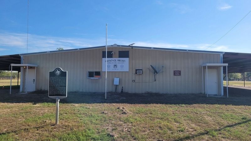
The view of the Campbellton Marker in front of the fire station
| On Saint Francis Avenue north of Campbell Blvd, on the right when traveling north. |
| On County Road 315W 0.2 miles east of Farm to Market Road 140, on the right when traveling east. |
| On Farm to Market Road 140 0.4 miles County Route 334, on the left when traveling south. |
| On County Route 347 1 mile south of County Route 346, on the left when traveling south. |
| On Farm to Market Road 2924 at Farm to Market Road 99, on the right when traveling south on Road 2924. |
| On Campbell Avenue at Circle Drive, on the left when traveling north on Campbell Avenue. |
| On Courthouse Circle Drive. |
| On Oak Street (State Highway 97) at Campbell Avenue, on the right when traveling east on Oak Street. Reported missing. |
| On Zanderson Avenue (State Highway 16) at Peach Street, on the right when traveling north on Zanderson Avenue. |
| On State Highway 97, on the right when traveling north. |
| On Oak Street (State Highway 97) 0.2 miles east of Jourdanton Avenue, on the right when traveling east. |
| Near Walton Avenue at Fig Street. |
| On Zanderson Avenue (State Highway 16) at Plum Street, on the left when traveling north on Zanderson Avenue. |
| On Campbell Avenue south of Elm Street, on the right when traveling south. |
| On Texas Route 173 0.6 miles west of County Route 301, on the right when traveling west. |
| On Texas Route 97 0.5 miles west of Spur 162, on the right when traveling west. |
| On Main Street at Zanderson Avenue ( Highway 16), on the right when traveling east on Main Street. |
| On State Highway 97, on the right when traveling north. |
| On Oak Street (State Highway 97) 0.2 miles east of Jourdanton Avenue, on the right when traveling east. |
| On Courthouse Circle Drive at Campbell Ave, on the left when traveling north on Courthouse Circle Drive. |
| On Oak Street (State Highway 97) 0.3 miles east of Jourdanton Avenue, on the right when traveling east. |
| On Zanderson Avenue (State Highway 16) at Commerce Street, on the right when traveling west on Zanderson Avenue. |
| On Old Applewhite Road at Bruce Road, on the right when traveling south on Old Applewhite Road. Reported missing. |
| On Verdi Road 1 mile west of Farm to Market Road 3006, on the right when traveling west. |
| On Pleasanton Road at Spur Ridge, on the left when traveling south on Pleasanton Road. |
| On Old Pleasanton Road 0.6 miles north of Bruce Road, on the left when traveling south. |
| On Shilo Road 0.5 miles south of Farm to Market Road 1470, on the left when traveling south. |
| On Somerset Road at Laredo Road on Somerset Road. |
| On Farm to Market Road 3175, on the right when traveling west. |
| On North Prarie Street at Farm to Market Road 2790 on North Prarie Street. |
| On Somerset Road at Mesquite Street, on the right when traveling south on Somerset Road. |
| On Interstate 35 Access Road 1.5 miles south of Benton City Road, on the right when traveling north. |
| On North Main Street at Virginia Street, on the left when traveling north on North Main Street. |
| On North Main Street at Virginia Street, on the right when traveling south on North Main Street. |
| On Coughran Road at Dead Horse Road on Coughran Road. Reported missing. |
| On State Road 97 at Parsons Road, on the right when traveling south on State Road 97. |
| On West College Street at North Reed Street, on the right when traveling west on West College Street. |
| On North Bryant Street north of Sutton Street, on the left when traveling north. |
| Near North Bryant Street at W Adams Street. |
| On Veterans Memorial Road at East Adams Street, on the right when traveling north on Veterans Memorial Road. |
| On East Bensdale Street (State Road 242) at 1st Street, on the right when traveling east on East Bensdale Street. |
| On West College Street at North Smith Street, on the right when traveling west on West College Street. |
| On 2nd Street (U.S. 281) at Settlers Xing, on the left when traveling north on 2nd Street. |
| On North Main Street at West Goodwin Street, on the left when traveling south on North Main Street. |
| On North Main Street at Patrick Ave, on the right when traveling south on North Main Street. |
| On West Adams Street at North Bryant Street, on the right when traveling west on West Adams Street. |
| On Verdi Road 1 mile west of Farm to Market Road 3006. |
| On East Bensdale Street (State Road 242) at 1st Street, on the right when traveling east on East Bensdale Street. |
| On Coughran Street (Farm to Market Road 1334) east of Main Street (U.S. 281), on the left when traveling east. |
| On East Adams Street at Hollingsworth Street, on the left when traveling east on East Adams Street. |
| On Casarez Road 0.3 miles north of Crane Road, on the right when traveling south. |
| On North Las Gallinas at Farm to Market Road 536, on the right when traveling north on North Las Gallinas. |
| On Verdi Road 1 mile west of Farm to Market Road 3006. |
| On Farm to Market Road 1784 at Verdi Road, on the right when traveling north on Route 1784. |
| On County Road 304 0.5 miles east of Farm to Market Road 2146. |
| On Route 2504 at Brooks Lane, on the left when traveling north on Route 2504. |
| On 4th Street at Avenue D, on the left when traveling south on 4th Street. |
| On Avenue H at Broadway, on the right when traveling east on Avenue H. |
| On E Gates Valley Road at Mangum Road, on the right when traveling east on E Gates Valley Road. |
| On Avenue H (Farm to Market Road 476) at 10th Street, on the right when traveling east on Avenue H. |
| On I Avenue at 4th Street ( Highway 282), on the right when traveling west on I Avenue. |
| On 6th Street at Ave D, on the right when traveling south on 6th Street. |
| On 4th Street at Avenue G, on the right when traveling south on 4th Street. |
| On Rutledge Road at Coble Rd, on the left when traveling north on Rutledge Road. |
| On Farm to Market Road 1333 at Curvier Road, on the left when traveling south on Route 1333. |
| On Avenue H at 6th Street, on the right when traveling east on Avenue H. |
| On Farm to Market Road 2504 0.5 miles south of Route 476, on the left when traveling south. |
| Near Jenschke Lane 0.9 miles west of Farm to Market Road 476, on the left when traveling west. |
| On Farm to Market Road 2504 0.5 miles north of Sandbranch Road, on the left when traveling north. |
| On Old Rock Road 0.3 miles south of Roseville Road, on the right when traveling south. |
| Near Old San Antonio Road 0.1 miles north of State Highway 16. |
| On Main Street (State Highway 16) at Hackberry Street, on the right when traveling north on Main Street. |
| On Highway 173 0.5 miles north of Highway 16 when traveling north. |
| On State Highway 16 at Old San Antonio Road, on the right when traveling south on State Highway 16. |
| On Main Street (State Highway 173) north of Hackberry Street, on the right when traveling north. |
| On Main Street (State Highway 16) at Hackberry Street, on the right when traveling north on Main Street. |
| On 11th Street at Cedar Street, on the right when traveling east on 11th Street. |
| On 11th Street at Hackberry Street, on the right when traveling north on 11th Street. |
| On State Highway 173 1 mile north of Farm to Market Road 2828, on the left when traveling north. |
| On Hwy 173 10.6 miles north of SR 16, on the left when traveling north. |
| On 11th Street at Cedar Creek, on the right when traveling north on 11th Street. |
| On Main Street (State Highway 173/16) at Hackberry Street, on the right when traveling south on Main Street. |
| On Main Street (State Highway 173/16) at Hackberry Street, on the right when traveling south on Main Street. |
| On Main Street (State Highway 16) at Hackberry Street, on the left when traveling north on Main Street. |
| On 11th Street at Cedar Street, on the right when traveling east on 11th Street. |
| On Old Medina Highway 0.1 miles west of Houston Street, on the right when traveling west. |
| On Main Street (State Highway 173) north of Hackberry Street, on the right when traveling north. |
| On Main Street (State Highway 16) at Pecan Street, on the right when traveling south on Main Street. |
| On Highway 470 1.5 miles west of Highway 16, on the right when traveling west. |
| Near Old San Antonio Road 0.1 miles north of State Highway 16. |
| Near Old San Antonio Road 0.1 miles north of State Highway 16. |
| On 12th Street, on the right when traveling west. |
| On 13th Street at Pecan Street, on the right when traveling north on 13th Street. |
| Near Old San Antonio Road 0.1 miles north of State Highway 16. |
| Near Old San Antonio Road 0.1 miles north of State Highway 16. |
| On Main Street (State Highway 16) at Hackberry Street, on the left when traveling north on Main Street. |
2081 entries matched your criteria. The first 100 are listed above.
Next 100 ⊳
