THE HISTORICAL
MARKER DATABASE
“Bite-Size Bits of Local, National, and Global History”


103 entries match your criteria. The first 100 are listed.                                               The final 3 ⊳


Historical Markers and War Memorials
in the Quad Cities Region

 
By Duane and Tracy Marsteller, July 8, 2023
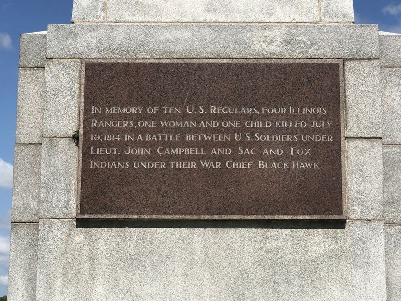
Campbell’s Island State Memorial (East face)
1 ► Illinois, Rock Island County, East Moline, Hampton Township — Campbell’s Island State Memorial —
On Island Avenue at State Street, on the right when traveling south on Island Avenue.
2 ► Illinois, Rock Island County, East Moline, Hampton Township — Peace Garden —
On Island Avenue south of State Street, on the right.
3 ► Illinois, Rock Island County, Hillsdale — Black Hawk War Campsite —
On Hurd Road 0.2 miles east of Jackson Street, on the right when traveling east.
4 ► Illinois, Rock Island County, Milan — Lincoln and the Black Hawk War —
On 10th Avenue West at 1st Street (U.S. 67), on the right when traveling west on 10th Avenue West.
5 ► Illinois, Rock Island County, Moline — Moline, City of Mills - Founded 1848 —
On 3rd Avenue A east of 15th Street, on the left when traveling east.
6 ► Illinois, Rock Island County, Rock Island — 15-Inch Rodman Gun —
On Rodman Avenue.
7 ► Illinois, Rock Island County, Rock Island — Augustana Memorial Amphitheater —
Near 9 1/2 Avenue east of 34th Street, on the left when traveling east.
8 ► Illinois, Rock Island County, Rock Island — Black Hawk: Saux Warrior — 1767-1838 —
Near 46th Avenue (Illinois Route 3) 0.2 miles east of 15th Street, on the right when traveling east.
9 ► Illinois, Rock Island County, Rock Island — Chippiannock Cemetery —
Near 12th Street at 29th Avenue, on the right when traveling north.
10 ► Illinois, Rock Island County, Rock Island — Connor House —
On 20th Street at 7th Avenue, on the left when traveling north on 20th Street.
11 ► Illinois, Rock Island County, Rock Island — Figure Eight Roller Coaster and Balloon Ascension Tower —
Near 46th Avenue (Illinois Route 3) 0.3 miles east of 15th Street, on the right when traveling east.
12 ► Illinois, Rock Island County, Rock Island — Fort Armstrong —
Near Rodman Avenue 0.1 miles Government Bridge, on the right when traveling east.
13 ► Illinois, Rock Island County, Rock Island — Fort Armstrong Hotel —
On 19th Street at 3rd Avenue, on the right when traveling north on 19th Street.
14 ► Illinois, Rock Island County, Rock Island — Fort Armstrong Sesquicentennial —
Near Fort Armstrong Road at Rodman Avenue, on the right when traveling south.
15 ► Illinois, Rock Island County, Rock Island — Illinois in the American Revolution —
Near 46th Avenue (Illinois Route 3) 0.2 miles east of 15th Street, on the right when traveling east.
Paid Advertisement
16 ► Illinois, Rock Island County, Rock Island — Old Main, Augustana College —
On 7th Avenue east of 35th Street, on the right when traveling east.
17 ► Illinois, Rock Island County, Rock Island — Robert Wagner House —
On 23rd Street at 9th Avenue, on the right when traveling south on 23rd Street.
18 ► Illinois, Rock Island County, Rock Island — Ruth Allison ‘41/Everett “Lefty” Anderson ‘39 —
On 7th Avenue west of 38th Street, on the right when traveling east.
19 ► Illinois, Rock Island County, Rock Island — Soldiers and Sailors Monument —
Near 12th Street at 29th Avenue.
20 ► Illinois, Rock Island County, Rock Island — The Black Hawk Inns —
Near 46th Avenue (Illinois Route 3) 0.3 miles east of 15th Street, on the right when traveling east.
21 ► Illinois, Rock Island County, Rock Island — The Stones in This Seat —
Near 7th Avenue west of 38th Street, on the right when traveling east.
22 ► Illinois, Rock Island County, Rock Island — To the Memory of La Main Cassee "The Broken Hand," a Fearless Sauk Chief —
Near 46th Avenue (Illinois Route 3) 0.3 miles east of 15th Street, on the right when traveling east.
23 ► Illinois, Rock Island County, Rock Island — USA M102, 105mm, Howitzer — Rock Island Arsenal —
On Rodman Avenue.
24 ► Illinois, Rock Island County, Rock Island — USA T131, 280mm, Heavy Motorized Gun — Rock Island Arsenal —
On Rodman Avenue.
25 ► Illinois, Rock Island County, Rock Island, KeyStone Neighborhood — Indian Boundary Line —
Near 38th Street south of 8th Avenue, on the right when traveling south.
26 ► Illinois, Rock Island County, Rock Island, Rock Island Arsenal — Fort Armstrong Cemetery Boulders —
On Fort Armstrong Road south of Rodman Avenue, on the right when traveling south.
27 ► Illinois, Rock Island County, Rock Island, Rock Island Arsenal — John Gale & Richard M. Coleman —
On Fort Armstrong Road south of Rodman Avenue, on the right when traveling south.
28 ► Illinois, Rock Island County, Rock Island, Rock Island Arsenal — Site of Fort Armstrong —
On Fort Armstrong Road south of Rodman Avenue, on the right when traveling south.
29 ► Illinois, Rock Island County, Silvis — Hero Street, U.S.A. —
On 2nd Street 0.1 miles south of 1st Avenue ( Route 84).
30 ► Iowa, Muscatine County, Muscatine — Address by President Lincoln — At the Dedication of The Gettysburg National Cemetery — November 19, 1863 —
On East 3rd Street just east of Walnut Street, on the left when traveling east.
31 ► Iowa, Muscatine County, Muscatine — Carry A. Nation — Feb. 11-12, 1901 —
On Cedar Street at East 2nd Street, on the right when traveling south on Cedar Street.
Paid Advertisement
32 ► Iowa, Muscatine County, Muscatine — First Presbyterian Church — 1856-1859 — Iowa Historic Site —
On Iowa Avenue just north of East 4th Street, on the right when traveling north.
33 ► Iowa, Muscatine County, Muscatine — Great River Road / Mark Twain Overlook —
On Lombard Street just south of East 2nd Street (Business U.S. 61), on the right when traveling south.
34 ► Iowa, Muscatine County, Muscatine — Mississippi River Record Flood Crest —
On Harbor Drive at Cedar Street, on the right when traveling east on Harbor Drive.
35 ► Iowa, Muscatine County, Muscatine — Muscatine County All Veterans Memorial —
On East 3rd Street just west of Mulberry Avenue, on the right when traveling west.
36 ► Iowa, Muscatine County, Muscatine — Muscatine Journal —
On Walnut Street just north of East Mississippi Drive (Business U.S. 61), on the left when traveling north.
37 ► Iowa, Muscatine County, Muscatine — Old Jail —
On East 4th Street just west of Mulberry Avenue, on the right when traveling west.
38 ► Iowa, Muscatine County, Muscatine — Papoose Creek —
On Sycamore Street at East 2nd Street, on the right when traveling south on Sycamore Street.
39 ► Iowa, Muscatine County, Muscatine — Pioneer Drug Store —
On East 2nd Street just west of Sycamore Street, on the left when traveling west.
40 ► Iowa, Muscatine County, Muscatine — Replica of the Statue of Liberty —
On East 3rd Street just east of Sycamore Street, on the right when traveling east.
41 ► Iowa, Muscatine County, Muscatine — Trinity Episcopal Church —
On East 2nd Street just west of Mulberry Avenue (Business U.S. 61), on the right when traveling west.
42 ► Iowa, Scott County, Bettendorf — 1 — Historic Davenport / Interstate 80 Bridge
Near Interstate 80 at milepost 300, 1.9 miles east of Interstate 74, on the right when traveling east. Reported missing.
43 ► Iowa, Scott County, Bettendorf — 2 — Historic Davenport / Interstate 80 Bridge
Near Interstate 80 at milepost 300, 1.1 miles west of Middle Road, on the right when traveling west. Reported permanently removed.
44 ► Iowa, Scott County, Davenport — Argyle Flats —
On North Brady Street (State Highway 461) at West 8th Street, on the left when traveling north on North Brady Street.
45 ► Iowa, Scott County, Davenport — B.J. Palmer House — 1874 - 1915 — Iowa Historic Site —
On North Brady Street (Business U.S. 61) at West 8th Street, on the left when traveling north on North Brady Street.
46 ► Iowa, Scott County, Davenport — Calvary Baptist Church - First Baptist Church — 1889 — Iowa Historic Site —
On North Perry Street at East 14th Street, on the right when traveling north on North Perry Street.
47 ► Iowa, Scott County, Davenport — Camp Roberts —
Near Eastern Avenue south of 29th Avenue, on the right when traveling south.
Paid Advertisement
48 ► Iowa, Scott County, Davenport — E. P. Adler House — Built 1916 — Iowa Historic Site —
On North Main Street at West High Street, on the right when traveling south on North Main Street.
49 ► Iowa, Scott County, Davenport — E.S. Barrows House — Physician — Built, 1853 —
On East 6th Street at Pershing Avenue, on the right when traveling west on East 6th Street.
50 ► Iowa, Scott County, Davenport — Farnam & 5th Street — The Celtic Heritage Trail
On Farnam Street at Federal Street on Farnam Street. Reported unreadable.
51 ► Iowa, Scott County, Davenport — George Copeland House — c.1875-80 — Iowa Historic Site —
On College Avenue at East 10th Street, on the right when traveling north on College Avenue.
52 ► Iowa, Scott County, Davenport — Leon “Bix” Beiderbecke House
On Grand Avenue south of Walling Court, on the right when traveling south. Reported damaged.
53 ► Iowa, Scott County, Davenport — 39 — Marion G. Crandell — 1872-1918 —
Near Eastern Avenue 0.3 miles west of East Rusholme Street, on the left when traveling west.
54 ► Iowa, Scott County, Davenport — Oakdale Cemetery Historic District —
On Eastern Avenue north of Wittenmyer Lane, on the right when traveling north.
55 ► Iowa, Scott County, Davenport — Original St. Ambrose College — The Celtic Heritage Trail —
On Iowa Street north of East 10th Street, on the right when traveling north.
56 ► Iowa, Scott County, Davenport — Parker-Ficke House — 1881-84 — Iowa Historic Site —
On North Main Street at West 12th Street, on the right when traveling south on North Main Street.
57 ► Iowa, Scott County, Davenport — Roland Harned House —
On Mississippi Avenue at East 9th Street, on the right when traveling south on Mississippi Avenue.
58 ► Iowa, Scott County, Davenport — Sacred Heart Roman Catholic Cathedral — 422 East 10th Street — The Celtic Heritage Trail —
On East 10th Street west of LeClaire Street, on the right when traveling west.
59 ► Iowa, Scott County, Davenport — Site of Civil War Camp Roberts —
Near Eastern Avenue south of East 29th Street, on the right when traveling south.
60 ► Iowa, Scott County, Davenport — The Gannon Home — 631 Farnam — The Celtic Heritage Trail —
On Farnam Street at East 7th Street, on the right when traveling north on Farnam Street.
61 ► Iowa, Scott County, Davenport — The Palmer Family Residence — Established 1912 —
On North Brady Street (Business U.S. 61) at West 8th Street, on the left when traveling north on North Brady Street.
62 ► Iowa, Scott County, Davenport — The Palmers —
On North Brady Street (Business U.S. 61) at West 8th Street, on the left when traveling north on North Brady Street.
63 ► Iowa, Scott County, Davenport — The Sharon Home — 728 Farnam Street — The Celtic Heritage Trail —
On Farnam Street at East 8th Street, on the left when traveling north on Farnam Street.
Paid Advertisement
64 ► Iowa, Scott County, Davenport — The Soldier's Monument —
On North Main Street south of West 12th Street, in the median.
65 ► Iowa, Scott County, Davenport — Trinity Episcopal Cathedral —
On North Main Street at West 12th Street, on the left when traveling south on North Main Street.
66 ► Iowa, Scott County, Davenport — Vander Veer Park Historic District — Built 1903 — Iowa Historic Site —
On North Main Street north of West High Street, on the left when traveling north.
67 ► Iowa, Scott County, Davenport — Wm. Radcliff House — Iowa Historic Site —
On College Avenue at East 9th Street, on the right when traveling south on College Avenue.
68 ► Iowa, Scott County, Davenport, Downtown Davenport — Blackhawk Purchase Treaty Commemorative —
On Biederbeck Drive.
69 ► Iowa, Scott County, Davenport, Downtown Davenport — Corner of Ripley and Third Streets — The Celtic Heritage Trail —
On North Ripley Street at West 3rd Street, on the right when traveling south on North Ripley Street.
70 ► Iowa, Scott County, Davenport, Downtown Davenport — First Chiropractic Adjustment —
On West 2nd Street at North Brady Street (Business U.S. 61), on the right when traveling east on West 2nd Street.
71 ► Iowa, Scott County, Davenport, Downtown Davenport — First Railroad Bridge Across the Mississippi —
On East River Drive (U.S. 67) south of Federal Street, on the right when traveling west.
72 ► Iowa, Scott County, Davenport, Downtown Davenport — Hibernian Hall — The Celtic Heritage Trail
On North Brady Street (State Highway 461) north of East 4th Street, on the right when traveling north. Reported missing.
73 ► Iowa, Scott County, Davenport, Downtown Davenport — Hose Station No. 1 — 1877 — Iowa Historic Site —
On Perry Street at Emerson Place, on the right when traveling north on Perry Street.
74 ► Iowa, Scott County, Davenport, Downtown Davenport — Leon “Bix” Beiderbecke — 1903-1931 —
On Beiderbecke Drive west of Ripley Street, on the left when traveling west.
75 ► Iowa, Scott County, Davenport, Downtown Davenport — Petersen Memorial Music Pavilion — Quad Cities Riverway —
On Beiderbecke Drive west of Ripley Street, on the left when traveling west.
76 ► Iowa, Scott County, Davenport, Downtown Davenport — St. Anthony's Church & Parish — Davenport Civil Rights History Walking Tour
On North Main Street at West 5th Street, on the right when traveling north on North Main Street. Reported unreadable.
77 ► Iowa, Scott County, Davenport, Downtown Davenport — St. Anthony's Roman Catholic Church — Iowa Historic Site —
On North Main Street at West 4th Street, on the right when traveling north on North Main Street.
78 ► Iowa, Scott County, Davenport, Downtown Davenport — The Democrat Newspaper Building — 411 Brady Street —
On Brady Street (State Highway 461) north of East 4th Street, on the right when traveling north.
79 ► Iowa, Scott County, Davenport, Downtown Davenport — The Dillon Fountain — Quad Cities Riverway —
On West River Drive (Business U.S. 61) at North Main Street, on the right when traveling east on West River Drive.
Paid Advertisement
80 ► Iowa, Scott County, Davenport, Downtown Davenport — The LeClaire House Hotel — The Celtic Heritage Trail —
On West 2nd Street at North Main Street, on the right when traveling west on West 2nd Street.
81 ► Iowa, Scott County, Davenport, Downtown Davenport — The Natatorium — Davenport Civil Rights History Walking Tour —
Near West River Drive (Business U.S. 61) at North Main Street, on the right when traveling east.
82 ► Iowa, Scott County, Davenport, Downtown Davenport — Union Station — Quad Cities Riverway —
On South Harrison Street at West River Drive (Business U.S. 61), on the right when traveling south on South Harrison Street.
83 ► Iowa, Scott County, Davenport, Village of East Davenport — Camp McClellan —
Near East 11th Street east of Jersey Ridge Road, on the right when traveling east.
84 ► Iowa, Scott County, Davenport, Village of East Davenport — Diedrich Busch House — E. Dav. developer — c. 1870 —
On East 11th Street west of Hillcrest Avenue and River Street, on the right when traveling west.
85 ► Iowa, Scott County, Davenport, West Davenport — Credit Island —
On Credit Island Road, on the right when traveling south.
86 ► Iowa, Scott County, Davenport, West Davenport — War of 1812 Memorial —
On Credit Island Road 0.5 miles south of US 61 (localy named West River Drive) (U.S. 61), on the right when traveling south.
87 ► Iowa, Scott County, LeClaire — Buffalo Bill Cody Birthplace —
On Territorial Road at 270th Avenue, on the right when traveling west on Territorial Road.
88 ► Iowa, Scott County, LeClaire — Buffalo Bill Museum —
On Jones Street east of Front Street when traveling east.
89 ► Iowa, Scott County, LeClaire — Green Tree / Buffalo Bill Trail —
On Wisconsin Street east of Front Street, on the right when traveling east.
90 ► Iowa, Scott County, LeClaire — LeClaire City Hall — Scott County Cody Trail —
On North Cody Road (U.S. 67) at Jones Street, on the right when traveling north on North Cody Road.
91 ► Iowa, Scott County, LeClaire — LeClaire Veterans Monument —
On Wisconsin Street east of Front Street when traveling east.
92 ► Iowa, Scott County, LeClaire — LeClaire's Rapid Pilots — Quad Cities Riverway
Near Wisconsin Street east of Front Street. Reported damaged.
93 ► Iowa, Scott County, LeClaire — Old Mill House — Capt. John W. VanSant —
On North Cody Road (U.S. 67) north of Ewing Street, on the right when traveling north.
94 ► Iowa, Scott County, LeClaire — The George Tromley, Jr. House — LeClaire Pilot's Houses — Scott County Cody Trail —
On Jones Street at North 2nd Avenue, on the left when traveling east on Jones Street.
95 ► Iowa, Scott County, LeClaire — The Horton-Suiter House — LeClaire Pilot's Houses — Scott County Cody Trail —
On North 2nd Street at Wisconsin Street, on the right when traveling south on North 2nd Street.
Paid Advertisement
96 ► Iowa, Scott County, LeClaire — The Jacob Suiter House — LeClaire Pilot's Houses — Scott County Cody Trail —
On South 2nd Street south of Dodge Street, on the right when traveling south.
97 ► Iowa, Scott County, LeClaire — The James Gamble House — LeClaire Historic Houses — Scott County Cody Trail —
On Wisconsin Street at 5th Street, on the right when traveling west on Wisconsin Street.
98 ► Iowa, Scott County, LeClaire — The Rambo House — LeClaire Pilot's Houses — Scott County Cody Trail —
On North Cody Road (U.S. 67) south of Ferry Street, on the right when traveling south.
99 ► Iowa, Scott County, LeClaire — The Samuel Van Sant House — LeClaire Pilot's Houses — Scott County Cody Trail —
On North Cody Road (U.S. 67) south of Ewing Street, on the right when traveling south.
100 ► Iowa, Scott County, LeClaire — The Stone House — LeClaire Historic Houses — Scott County Cody Trail —
On North 2nd Street north of Walnut Street, on the right when traveling north.

103 entries matched your criteria. The first 100 are listed above. The final 3 ⊳

 
 
CeraNet Cloud Computing sponsors the Historical Marker Database.
This website earns income from purchases you make after using our links to Amazon.com. We appreciate your support.
Paid Advertisement
Nov. 11, 2026