By Duane and Tracy Marsteller, June 27, 2021
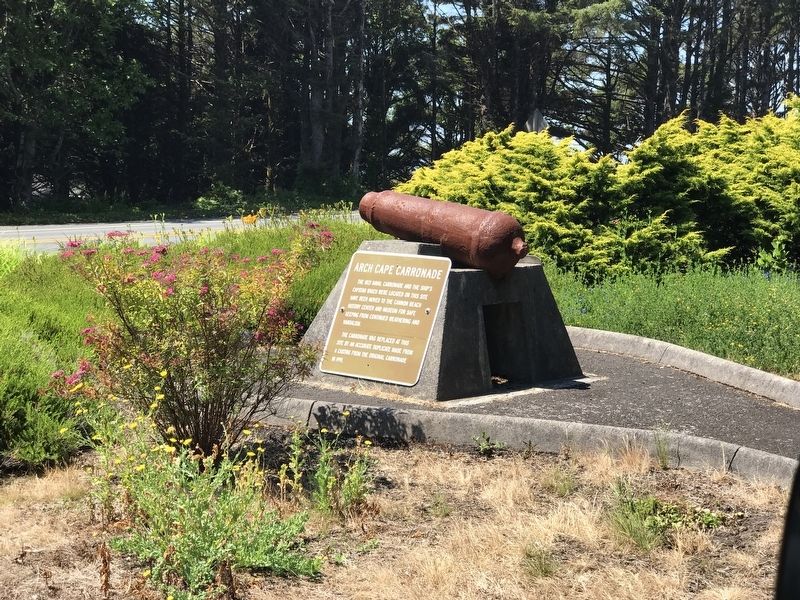
Arch Cape Carronade Marker
| On Oregon Coast Highway (U.S. 101) north of Carnahan Road North, on the right when traveling north. |
| On Oregon Coast Highway (U.S. 101) north of Carnahan Road N, on the right when traveling north. |
| On Oregon Coast Highway (U.S. 101) north of Carnahan Road North, on the right when traveling north. |
| Near Coxcomb Drive 0.7 miles 15th Street. |
| On East Columbia River Highway (U.S. 30) at 14th Street, on the left when traveling east on East Columbia River Highway. |
| Near East Columbia River Highway (U.S. 30) east of 16th Street, on the left when traveling east. |
| Near East Columbia River Highway (U.S. 30) west of 16th Street, on the left when traveling east. |
| On Exchange Street at 7th Street, on the left when traveling east on Exchange Street. |
| Near Fort Clatsop Road 0.6 miles south of Warrenton-Astoria Highway (Business U.S. 101). |
| On West Marine Drive (U.S. 101) at Taylor Street on West Marine Drive. |
| Near East Columbia River Highway (U.S. 30) west of 12th Street, on the left when traveling east. |
| On Franklin Avenue west of 14th Street, on the left when traveling west. |
| On 7th Street south of Duane Street, on the left when traveling south. |
| Near 8th Street south of Duane Street, on the right when traveling south. |
| On Exchange Street east of 12th Street, on the left when traveling east. |
| On Marine Drive at 20th Street, on the left when traveling east on Marine Drive. |
| Near East Columbia River Highway (U.S. 30) north of 14th Street, on the right when traveling west. |
| Near Coxcomb Drive 0.7 miles 15th Street. |
| On Astor Street at 9th Street, on the left when traveling east on Astor Street. |
| On Leif Erikson Drive (U.S. 30) near 34th Street, on the left when traveling west. |
| On Marine Drive (U.S. 30) at 30th Street, on the right when traveling west on Marine Drive. |
| On Leif Erikson Drive (U.S. 30) near 34th Street, on the left when traveling west. |
| On Warrenton-Astoria Highway (Business U.S. 101) at Fort Clatsop Road, on the left when traveling west on Warrenton-Astoria Highway. |
| Near Bay Street north of West Marine Drive (U.S. 30) when traveling north. |
| On 14th Street south of Columbia River Highway (U.S. 30), on the left when traveling north. |
| Near East Columbia River Highway (U.S. 30) east of 11th Street, on the left when traveling east. |
| On Leif Erikson Drive (U.S. 30) near 34th Street, on the left when traveling west. |
| Near East Columbia River Highway (U.S. 30) east of 15th Street, on the left when traveling east. |
| On Marine Drive (U.S. 30) at 20th Street, on the left when traveling east on Marine Drive. |
| Near East Columbia River Highway (U.S. 30) north of 14th Street, on the right when traveling west. |
| On Exchange Street at 15th Street, on the right when traveling west on Exchange Street. |
| On Fort Clatsop Road near Business U.S. 101. |
| On Jerome Avenue at 15th Street, on the left when traveling east on Jerome Avenue. |
| On West Marine Drive (U.S. 30) near Hume Avenue, on the left when traveling west. |
| On Exchange Street at 15th Street on Exchange Street. |
| On West Marine Drive at Columbia Avenue, on the left when traveling west on West Marine Drive. |
| On Columbia Avenue at West Marine Drive (U.S. 30), on the right when traveling north on Columbia Avenue. |
| On Burnside Loop near Columbia River Highway (U.S. 30). |
| On Duane Street at 7th Street, on the right when traveling west on Duane Street. |
| On Burnside Loop near Columbia River Highway (U.S. 30), on the right when traveling west. |
| Near Coxcomb Drive 0.7 miles 15th Street. |
| Near Fort Clatsop Road near Business U.S. 101. |
| Near West Marine Drive (U.S. 30) near Melbourne Avenue, on the right when traveling east. |
| Near Fort Clatsop Road near Warrenton-Astoria Highway (Business U.S. 101), on the right when traveling south. |
| Near Fort Clatsop Road near Business U.S. 101. |
| On Astoria Riverwalk, on the right when traveling east. |
| On Oregon Coast Highway (U.S. 101) near Radar Road, on the right when traveling south. |
| Near Ecola State Park Road, on the right when traveling west. |
| On Oregon Coast Highway (U.S. 101) near Radar Road, on the right when traveling east. |
| Near Peter Iredale Rd near Burma Road. Reported permanently removed. |
| Near Pacific Drive near Russell Drive. |
| On Delaura Beach Lane near Ridge Road, on the right when traveling west. |
| Near Peter Iredale Rd near Burma Road. Reported permanently removed. |
| Near Sunset Highway (Route 26 at milepost 28) near Olson Road, on the right when traveling west. |
| Near South Promenade near Avenue U. |
| Near Sunset Highway (Route 26 at milepost 28) near Olson Road, on the right when traveling west. |
| On Beach Drive near Avenue A. |
| Near Lewis and Clark Way near Beach Drive, on the left when traveling west. |
| Near Lewis and Clark Way near Beach Drive, on the left. |
| Near Lewis and Clark Way near Beach Drive, on the left when traveling west. |
| On Sunset Highway (Route 26 at milepost 28) near Olson Road. |
| Near South Promenade at Avenue A. |
| On Iredale Street 0.1 miles north of 5th Street, on the left when traveling east. |
| On Chicago Avenue SE south of 2nd Street SW, on the right when traveling south. |
| Near Bullards Beach Road 2.8 miles east of U.S. 101 when traveling east. |
| On Parkersburg Road, on the right when traveling south. |
| On Oregon Coast Highway (U.S. 101) north of East Market Avenue, on the right when traveling north. |
| On Oregon Coast Highway (U.S. 101) north of East Market Avenue, on the right when traveling north. |
| On Oregon Coast Highway (U.S. 101) north of Hall Avenue, on the right when traveling north. |
| On Oregon Coast Highway (U.S. 101) north of Hall Avenue, on the right when traveling north. |
| On Oregon Route 42 north of Confusion Hill Road, on the right when traveling north. |
| On Oregon Coast Highway (U.S. 101) north of East Market Avenue, on the right when traveling north. |
| On Oregon Coast Highway (U.S. 101) north of Central Avenue, on the right when traveling north. |
| Near North Front Street, on the right when traveling north. |
| On Oregon Coast Highway (U.S. 101) north of Central Avenue, on the right when traveling north. |
| Near Cape Arago Highway 5 miles west of Seven Devils Road. |
| On Oregon Coast Highway (U.S. 101) north of Hall Avenue, on the right when traveling north. |
| On Central Avenue just east of Oregon Coast Highway (southbound) (U.S. 101), on the left when traveling east. |
| On Oregon Coast Highway (U.S. 101) north of Anderson Avenue, on the right when traveling north. |
| On Oregon Coast Highway (U.S. 101) north of Anderson Avenue, on the right when traveling north. |
| On Oregon Coast Highway (U.S. 101) north of Anderson Avenue, on the right when traveling north. |
| On South Empire Boulevard south of Wisconsin Avenue, on the right when traveling north. |
| On Oregon Coast Highway (U.S. 101) north of Anderson Avenue, on the right when traveling north. |
| On Oregon Coast Highway (U.S. 101) north of Anderson Avenue, on the right when traveling north. |
| On Oregon Coast Highway (U.S. 101) north of Anderson Avenue, on the right when traveling north. |
| On Oregon Coast Highway (U.S. 101) north of Central Avenue, on the right when traveling north. |
| On Oregon Coast Highway (U.S. 101) north of Central Avenue, on the right when traveling north. |
| On Oregon Coast Highway (U.S. 101) south of Central Avenue, on the right when traveling south. |
| On Oregon Coast Highway (U.S. 101) north of Central Avenue, on the right when traveling north. |
| On Oregon Coast Highway (U.S. 101) 0.2 miles south of Marine Way, on the right when traveling south. |
| On Orgeon Coast Highway (U.S. 101 at milepost 346), on the right when traveling south. |
| On North Bank Chetco River Road at Oregon Coast Hwy (U.S. 101), on the right when traveling south on North Bank Chetco River Road. |
| On Oregon Coast Hwy (U.S. 101), on the left when traveling north. |
| On Jerry Flat Road (Oregon Route 595), on the left when traveling east. |
| On Ellensburg Avenue (U.S. 101) north of Gauntlett Street, on the right when traveling north. |
| On Oregon Coast Hwy (U.S. 101), on the right when traveling north. |
187 entries matched your criteria. The first 100 are listed above.
The final 87 ⊳
