By Mark Hilton, October 25, 2020
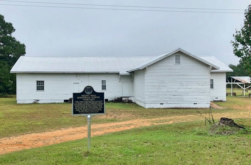
Mount Sinai Rosenwald School and marker.
GEOGRAPHIC SORT Title Sort Marker Number Sort Marker Number Sort N Marker Number Sort T Publication Order Sort Publication Order Sort A Erected Year Sort Most Viewed Sort Most Recent-Interest Sort Most Recently Changed Sort SEE FAQ #33 FOR DESCRIPTIONS
On County Road 57 just north of County Road 6, on the right when traveling north.
On Alabama Route 225, on the left when traveling north.
On Old Troy Road, on the left when traveling west.
Near County Road 267, 0.8 miles north of County Road 216, on the left when traveling north.
On County Road 425, on the left when traveling south.
On Middle School Road north of Old Lee Highway (County Road 20), on the left when traveling north.
On Lancaster Street, 0.1 miles north of Holtville Road (Alabama Route 111), on the right when traveling north.
On Martin Luther King Avenue north of McGlasker Street, on the right when traveling north.
On Oak Grove Road, 0.1 miles west of Alabama Route 69, on the right when traveling west.
On North Broad Street (Alabama Route 173) 0.1 miles south of North Railroad Street (County Road 7), on the left when traveling south.
On North Broad Street (Alabama Route 173) 0.1 miles north of North Railroad Street (County Route 7), on the right when traveling north.
On Rosenwald Street south of Taylor Street, on the right when traveling south.
On Stage Road (Alabama Route 14) 0.4 miles east of Arrowhead Road (County Road 188), on the right when traveling east.
On Tuskegee Street (Alabama Route 81) at Shiloh Road, on the right when traveling north on Tuskegee Street.
On Moton Drive at Booker T. Washington Boulevard on Moton Drive.
Paid Advertisement
On Meridian Street, 0.2 miles north of Chase Road NE, on the left when traveling north.
On Toney School Road, 0.2 miles east of Dan Crutcher Road, on the left when traveling east.
On Government Boulevard (U.S. 90) 0.5 miles west of Ramsey Road, on the right when traveling west.
On School Spur Road, 0.3 miles south of Pettus Road (County Road 19), on the right when traveling south.
On Old Wetumpka Highway (County Road 74) at Brooks Road, on the left when traveling north on Old Wetumpka Highway.
On Jim Locke Road at Copper Road, on the left when traveling east on Jim Locke Road.
On Buerkle Street, on the left when traveling south.
On Caddo Street at North 16th Street, on the right when traveling west on Caddo Street.
On Wright Avenue at South Ringo Street, on the right when traveling west on Wright Avenue.
On Northwest 141st Street at Northwest 158th Avenue, on the left when traveling north on Northwest 141st Street.
On Southeast Douglass Street at Northwest 180th Place, on the left when traveling north on Southeast Douglass Street.
On Bay Avenue at East 9th Court, on the left when traveling south on Bay Avenue.
On Northwest 7th Terrace at Northwest 6th Street, in the median on Northwest 7th Terrace.
On Orange Street at Clay Street, on the right when traveling south on Orange Street.
On Mamie Scott Drive north of Cypress Street, on the left when traveling north.
On North Highland Street at East Jackson Avenue on North Highland Street.
Paid Advertisement
On 27908 Virgil Hawkins Circle, 0.1 miles south of North Quarters Raod, on the right when traveling south.
On Gamble Street at South Martin Luther King Jr Boulevard, on the right when traveling west on Gamble Street.
Near West Brevard Street at North Macomb Street, on the left when traveling east.
On South 10th Street at Fir Street, on the right when traveling north on South 10th Street.
On Seacrest Boulevard at 10th Avenue, on the right when traveling south on Seacrest Boulevard.
On Limestone Creek Road north of Australian Street, on the right when traveling south.
On Third Street, on the right when traveling north.
On Avenue O Northeast, 0.1 miles east of 7th Street Northeast, on the left when traveling east.
On North Orange Avenue just south of 35th Street, on the left when traveling north.
On Douglas Street Southwest at Lafayette Avenue Southwest, on the right when traveling east on Douglas Street Southwest.
On Martin Luther King Jr. Avenue at 6th Street, on the left when traveling west on Martin Luther King Jr. Avenue.
On East Dundee Avenue at East Retta Street, on the right when traveling north on East Dundee Avenue.
Near East Blue Springs Avenue west of South Thorpe Avenue, on the right when traveling east.
On Joe Frank Harris Parkway (U.S. 41) 0.1 miles south of Willow Lane, on the right when traveling south.
On 1st Avenue, 0.1 miles south of Strickland Road, on the right when traveling south.
On U.S. 80 at Willow Hill Road, on the right when traveling east on U.S. 80.
Paid Advertisement
On Lehigh Avenue at Pin Point Avenue, on the left when traveling south on Lehigh Avenue.
On Martin Luther King Jr. Drive at Progress Street, on the right when traveling west on Martin Luther King Jr. Drive.
On North Richardson Street north of Colfax Street, on the right when traveling north.
On Chatham Street (Georgia Route 49) at Asbury Road, on the right when traveling west on Chatham Street.
On Radcliff Avenue, 0 miles north of Martin Luther King Avenue, on the left when traveling north.
On 10th Avenue at 8th Street, on the right when traveling north on 10th Avenue.
On Hiram Douglasville Highway (Georgia Route 92) 0 miles south of Alexander Street, on the right when traveling south.
On South Ellis Avenue at East 49th Street, on the right when traveling north on South Ellis Avenue.
On South 8th Street, 0.1 miles north of East Jackson Street, on the left when traveling north.
On Dixie Highway East (U.S. 31W) just north of North Crestwood Street, on the left when traveling west.
On North Kentucky Avenue at Couch Street, on the right when traveling north on North Kentucky Avenue.
On East Main Street at South Harrison Street, on the right when traveling east on East Main Street.
On Parker Lane at Raymond Road (Kentucky Route 324), on the left when traveling north on Parker Lane.
On South Magnolia Street at West Lexington Street, on the left when traveling north on South Magnolia Street.
On North 1st Street (Kentucky Route 53) south of Woodcreek Drive, on the left when traveling south.
On South Weisenberger Mill Road at Zion Hill Lane, on the right when traveling south on South Weisenberger Mill Road.
Paid Advertisement
On West Main Avenue just west of Barry Street, on the left when traveling west.
On Lessard Street at Williams Street, on the right when traveling north on Lessard Street.
On Williams Street near Lessard Street.
On Dixie Shreveport Road (Louisiana Route 3049) 0.5 miles north of Whitefield Circle, on the right when traveling north.
On St. John Road (Parish Road 173) 0.1 miles north of Buster Johnson Road.
On U.S. 167 west of Durio Road, on the right when traveling west.
On George and Marion Phelps Lane at Vincent Street, on the right when traveling north on George and Marion Phelps Lane.
On Solley Road, 1.6 miles south of Fort Smallwood Road (Maryland Route 173), on the right when traveling south.
On Dorsey Road (State Road 176) 0.1 miles west of Arundel Mills Blvd / New Ridge Road (State Road 713), on the right when traveling west.
On Mountain Road (Maryland Route 177/648) 0.1 miles east of Freetown Road, on the right when traveling west.
On Berlin Avenue at School Road, on the right when traveling north on Berlin Avenue.
On Belle Grove Road (Maryland Route 170), on the right when traveling east.
On Queenstown Road, 0.1 miles south of Kearneys Lane, on the right when traveling north.
On Beallsville Road (Maryland Route 109) just north of Darnestown Road (Maryland Route 28), on the right when traveling south.
On North Washington Street north of Beall Avenue. Reported permanently removed.
Paid Advertisement
On North Washington Street at Beall Avenue, on the left when traveling north on North Washington Street.
On Brooke Road, 0.1 miles west of Chandlee Mill Road, on the right when traveling west.
On Brooke Road, 0.1 miles west of Chandlee Mill Road, on the right when traveling west.
On Brooke Road, 0.1 miles west of Chandlee Mill Road, on the right when traveling west.
On East Randolph Road just east of New Hampshire Avenue (Maryland Route 650), on the right when traveling east.
Near Old Muirkirk Road. Reported permanently removed.
On Old Fort Road, on the right when traveling north.
Near 55th Avenue south of Berwyn Road, on the right when traveling south. Reported damaged.
Near Baltimore Avenue (U.S. 1) north of Campus Drive, on the right when traveling north.
On Baltimore Avenue (U.S. 1) at Lakeland Road, on the left when traveling south on Baltimore Avenue.
Near Central Avenue (Maryland Route 214) east of Ritchie Road (Truck Route Maryland Road 214).
Near Lowland Drive near Fiji Avenue.
On Central Avenue (State Road 214) 0.2 miles west of Capitol Beltway (Interstate 95/495), on the right when traveling west.
On Annapolis Road (Maryland Route 450) at Baltimore Lane when traveling south on Annapolis Road.
On Sharptown/Mardela Springs Road (Maryland Route 313).
Paid Advertisement
On Live Oak Avenue at Silver Lane, on the right when traveling north on Live Oak Avenue.
On Clarke Avenue north of West Railroad Street, on the left when traveling north.
On U.S. 51 at Church Street, on the right when traveling north on U.S. 51.
On Washington Avenue west of North 5th Street, on the left when traveling west.
213 entries matched your criteria. The first 100 are listed above.
Next 100 ⊳