73 entries match your criteria.
Coal Heritage Trail Historical Markers
The Coal Heritage Trail is a driving trail that winds through more than (13 counties) 187 rugged miles of scenic industrial heritage, where thousands of hard-working miners labored to produce the coal which created modern America.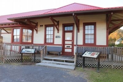
By J. J. Prats, October 17, 2015
Two Markers at the Dungannon Depot
1 ► Virginia, Scott County, Dungannon — Dungannon Depot —  |
| On Veterans Memorial Highway (Virginia Route 65) east of Route 72, on the left when traveling east. | |||
| 2 ► Virginia, Scott County, Dungannon — Flanary Archaeological Site — |
| On Veterans Memorial Highway (Virginia Route 65) west of Route 72, on the left when traveling east. | |||
| 3 ► West Virginia, Boone County, Whitesville — Big Coal River — An Important and Historical Water Trail Serving Man and Industry — Coal Heritage Trail — |
| On Coal River Road (West Virginia Route 3) at Bridge Avenue, on the left when traveling east on Coal River Road. | |||
| 4 ► West Virginia, Fayette County, Ansted — Did You Know? — |
| Near East Main Street (U.S. 60) at Holley Street. | |||
| 5 ► West Virginia, Fayette County, Ansted — Hawks Nest Strike — |
| Near East Main Street (U.S. 60) at Holley Street. | |||
| 6 ► West Virginia, Fayette County, Ansted — The Town of Ansted — America's Byways / National Coal Heritage Area — |
| On Holley Street at Midland Trail (U.S. 60), on the right when traveling north on Holley Street. | |||
| 7 ► West Virginia, Fayette County, Ansted — William Nelson Page — |
| Near East Main Street (U.S. 60) at Holley Street. | |||
| 8 ► West Virginia, Fayette County, Lansing — New River Gorge Scenic Drives — New River Gorge National River — |
| On Visitor Center Road. | |||
| 9 ► West Virginia, Fayette County, Mossy — Coal Camp History — |
| On Bishop Ranch (West Virginia Route 612) at Milburn Road (County Route 1/5) when traveling east on Bishop Ranch. | |||
| 10 ► West Virginia, Fayette County, Mount Hope — Historic Mount Hope Walking Tour — |
| On Main Street (West Virginia Route 211) at South Center Avenue, on the right when traveling north on Main Street. | |||
| 11 ► West Virginia, Fayette County, Mount Hope — Mine Safety — Mt. Hope — Coal Heritage Trail — |
| On Main Street (West Virginia Route 211) 0.1 miles north of North Michigan Avenue, on the right when traveling north. | |||
| 12 ► West Virginia, Fayette County, Mount Hope — New River Coalfield — Mt. Hope — Coal Heritage Trail — |
| On West Virginia 211, on the right when traveling east. | |||
| 13 ► West Virginia, Fayette County, Mount Hope — Siltix Mine Disaster — |
| On West Virginia Route 16 at Route 211, on the right when traveling west on West Virginia Route 16. | |||
| 14 ► West Virginia, Fayette County, Mount Hope — The Coal Companies — Mt. Hope — Coal Heritage Trail — |
| On Main Street, on the right when traveling east. | |||
| 15 ► West Virginia, Fayette County, Mount Hope — The Coming of the Railroads — Mt. Hope — Coal Heritage Trail — |
| On Main Street (West Virginia Route 211) 0.1 miles east of North Michigan Avenue, on the right when traveling east. | |||
| 16 ► West Virginia, Fayette County, Whipple Junction — Community Life in a Coal Camp — Whipple — Coal Heritage Trail — National Coal Heritage Area Interpretive Site — |
| On Okey L Patterson Road (West Virginia Route 612) at Scarbro Road (Local Route 1/5), on the right when traveling east on Okey L Patterson Road. | |||
| 17 ► West Virginia, Fayette County, Whipple Junction — Disaster Underground — Coal Heritage Trail — National Coal Heritage Area Interpretive Site — |
| On Okey L Patterson Road (West Virginia Route 612) at Scarbro Road (Route 1/5), on the right on Okey L Patterson Road. | |||
| 18 ► West Virginia, Fayette County, Whipple Junction — Labor Strikes and Conflicts — Whipple — Coal Heritage Trail — National Coal Heritage Area Interpretive Site — |
| On Okey L Patterson Road (West Virginia Route 612) at Scarbro Road (Local Route 1/5), on the right when traveling east on Okey L Patterson Road. | |||
| 19 ► West Virginia, Fayette County, Whipple Junction — The Coal Barons — Coal Heritage Trail — National Coal Heritage Area Interpretive Site — |
| On Okey L Patterson Road (West Virginia Route 612) at Scarbro Road (Route 1/5), on the right when traveling east on Okey L Patterson Road. | |||
| 20 ► West Virginia, Fayette County, Whipple Junction — The White Oak Valley — Coal Heritage Trail — National Coal Heritage Area Interpretive Site — |
| On Okey L Patterson Road (West Virginia Route 612) at Scarbro Road (Route 1/5), on the right when traveling east on Okey L Patterson Road. | |||
| 21 ► West Virginia, McDowell County, Ashland — Ashland Coal and Coke — National Coal Heritage Trail — |
| On Cherokee Road (County Route 17) 5.8 miles east of Coal Heritage Road in Northfork (U.S. 52), on the right when traveling east. | |||
| 22 ► West Virginia, McDowell County, Ashland — Miners’ Pay — National Coal Heritage Trail — |
| On Cherokee Road (County Route 17) 5.8 miles east of Coal Heritage Road in Northfork, on the right when traveling east. | |||
| 23 ► West Virginia, McDowell County, Ashland — No Work Tomorrow — National Coal Heritage Trail — |
| On Cherokee Road (County Route 17) 5.8 miles east of Coal Heritage Road in Northfork (U.S. 52), on the right when traveling east. | |||
| 24 ► West Virginia, McDowell County, Ashland — The Company Store — Ashland — National Coal Heritage Trail — |
| On Cherokee Road (County Route 17) 5.8 miles east of Coal Heritage Road in Northfork (U.S. 52), on the right when traveling east. | |||
| 25 ► West Virginia, McDowell County, Ashland — Young Miners — National Coal Heritage Trail — |
| On Cherokee Road (County Route 17) 5.8 miles Coal Heritage Road in Northfork (U.S. 52), on the left when traveling east. | |||
| 26 ► West Virginia, McDowell County, Kimball — 2001 – 2002 Floods — National Coal Heritage Trail — |
| On Main Street (U.S. 52) 0.1 miles south of Lavania Street, on the right when traveling south. | |||
| 27 ► West Virginia, McDowell County, Kimball — African Americans — National Coal Heritage Trail — |
| On Main Street (U.S. 52) 0.1 miles south of Lavania Street, on the right when traveling south. | |||
| 28 ► West Virginia, McDowell County, Kimball — Coal Company Town — Kimball — National Coal Heritage Trail — |
| On Main Street (U.S. 52) 0.2 miles south of Lavania Street, on the left when traveling south. | |||
| 29 ► West Virginia, McDowell County, Kimball — Dr. Roscoe Conklin Harrison — Harrison Memorial Hospital — |
| On Coal Heritage Road (U.S. 52), on the right when traveling east. | |||
| 30 ► West Virginia, McDowell County, Kimball — Frederick Kimball — National Coal Heritage Trail — |
| On Main Street (U.S. 52) 0.1 miles south of Lavinia Street, on the right when traveling south. | |||
| 31 ► West Virginia, McDowell County, Kimball — Heartland Corridor Project — Kimball — National Coal Heritage Trail — |
| On Main Street (U.S. 52) 0.2 miles south of Lavania Street, on the left when traveling south. | |||
| 32 ► West Virginia, McDowell County, Kimball — Henrietta Dismukes Hospital and Nurses’ Home — |
| On Lavania Street at One Way Street, on the right when traveling north on Lavania Street. | |||
| 33 ► West Virginia, McDowell County, Kimball — Houston Company Store — National Coal Heritage Trail — |
| On Main Street (U.S. 52) 0.1 miles south of Lavania Street, on the right when traveling south. | |||
| 34 ► West Virginia, McDowell County, Kimball — Kimball War Memorial — National Coal Heritage Trail — |
| On Main Street (U.S. 52) 0.1 miles south of Lavania Street, on the right when traveling south. | |||
| 35 ► West Virginia, McDowell County, Welch — Ethnic Population of McDowell County — National Coal Heritage Trail — |
| On Wyoming Street (West Virginia Route 16) at Bank Street, on the right when traveling north on Wyoming Street. | |||
| 36 ► West Virginia, McDowell County, Welch — Hatfield & Chambers — Killed on the Courthouse Steps — National Coal Heritage Trail — |
| On Wyoming Street (West Virginia Route 16) at Bank Street, on the right when traveling north on Wyoming Street. | |||
| 37 ► West Virginia, McDowell County, Welch — Heartland Corridor Project — Welch — National Coal Heritage Trail — |
| On McDowell Street (West Virginia Route 16) south of Wyoming Street ( Route 16), on the right when traveling south. | |||
| 38 ► West Virginia, McDowell County, Welch — Isaiah A. Welch — National Coal Heritage Trail — |
| On Wyoming Street (West Virginia Route 26) at Bank Street, on the right when traveling north on Wyoming Street. | |||
| 39 ► West Virginia, McDowell County, Welch — McDowell County — National Coal Heritage Trail — |
| On Wyoming Street (West Virginia Route 16) at Bank Street, on the right when traveling north on Wyoming Street. | |||
| 40 ► West Virginia, McDowell County, Welch — McDowell County Courthouse — National Coal Heritage Trail — |
| On Wyoming Street (West Virginia Route 16) at Bank Street, on the right when traveling north on Wyoming Street. | |||
| 41 ► West Virginia, McDowell County, Welch — Welch History — National Coal Heritage Trail — |
| On McDowell Street (West Virginia Route 16) near Wyoming Street, on the right when traveling south. | |||
| 42 ► West Virginia, Mercer County, Bluefield — Bluefield Rail Yards — Bluefield — |
| On Princeton Avenue (U.S. 19) west of Tony Wagner Avenue, on the right when traveling east. | |||
| 43 ► West Virginia, Mercer County, Bluefield — Coal Heritage Trail — |
| On Princeton Avenue (U.S. 19) at Tony Wagner Avenue, on the right when traveling east on Princeton Avenue. | |||
| 44 ► West Virginia, Mercer County, Bluefield — Gateway to the "Billion Dollar Coalfield" — National Coal Heritage Area — Coal Heritage Trail — |
| On Princeton Avenue (U.S. 19) west of Tony Wagner Avenue, on the right when traveling east. | |||
| 45 ► West Virginia, Mercer County, Bluefield — Legends and Landmarks — Bluefield, West Virginia National Coal Heritage Area — Coal Heritage Trail — |
| On Princeton Avenue (U.S. 19) 52 miles east of Bland Street, on the right when traveling east. | |||
| 46 ► West Virginia, Mercer County, Bluefield — Railroads: Prelude Prelude to Prosperity — National Coal Heritage Area — Coal Heritage Trail — |
| On Princeton Avenue (U.S. 19) west of Tony Wagner Avenue, on the right when traveling east. | |||
| 47 ► West Virginia, Mercer County, Bluefield — West Virginia's Most Diverse City — Bluefield, West Virginia National Coal Heritage Area — Coal Heritage Trail — |
| On Princeton Avenue (U.S. 19) east of Bland Street (U.S. 52), on the right when traveling east. | |||
| 48 ► West Virginia, Mercer County, Bluefield — Where the Chicory Blooms — Bluefield, West Virginia National Coal Heritage Area — Coal Heritage Trail — |
| On Princeton Avenue (U.S. 19) east of Bland Street (U.S. 52), on the right when traveling east. | |||
| 49 ► West Virginia, Mercer County, Bramwell — Developing the Coal Field — National Coal Heritage Trail — |
| On Main Street (County Route 120) at Simmons Avenue (Route 120), on the left when traveling west on Main Street. | |||
| 50 ► West Virginia, Mercer County, Bramwell — Evolution of a Town — National Coal Heritage Trail — |
| On Main Street (County Route 120) at Simmons Avenue (County Route 120) when traveling west on Main Street. | |||
| 51 ► West Virginia, Mercer County, Bramwell — The Coal Barons — National Coal Heritage Trail — |
| On Main Street (County Route 120) at Simmons Avenue, on the left when traveling east on Main Street. | |||
| 52 ► West Virginia, Mercer County, Bramwell — The Coming of the Railroad — National Coal Heritage Trail — |
| On Simmons Avenue. | |||
| 53 ► West Virginia, Mercer County, Bramwell — The Workers — National Coal Heritage Trail — |
| On Main Street (County Route 120) at Simmons Avenue (County Route 120), on the left when traveling west on Main Street. | |||
| 54 ► West Virginia, Mingo County, Matewan — The Battle of Matewan — National Coal Heritage Trail — |
| On Ferrell Street at Hatfield Street, on the right when traveling north on Ferrell Street. | |||
| 55 ► West Virginia, Mingo County, Williamson — Williamson and the Railroad — Williamson — National Coal Heritage Trail — |
| On Fourth Avenue (U.S. 52) at Logan Street, on the right when traveling south on Fourth Avenue. | |||
| 56 ► West Virginia, Mingo County, Williamson — Williamson Historic District — National Coal Heritage Trail — |
| On 4th Avenue (U.S. 52) just south of Logan Street, on the right when traveling north. | |||
| 57 ► West Virginia, Raleigh County, Amigo — Byrd Prillerman High School — Coal Heritage Trail — |
| On Tams Highway (West Virginia Route 16) 0.5 miles north of Amigo-Egeria Road (County Route 35), on the right when traveling south. | |||
| 58 ► West Virginia, Raleigh County, Beckley — Aerial Gateway to Beckley — |
| On Industrial Drive just west of Lewis Ritchie Drive, on the right when traveling west. | |||
| 59 ► West Virginia, Raleigh County, Beckley — Beckley's Flying Circuses — |
| On Industrial Drive just west of Lewis Ritchie Drive, on the right when traveling west. | |||
| 60 ► West Virginia, Raleigh County, Beckley — Cleared for Takeoff — |
| On Industrial Drive just east of Lewis Ritchie Drive, on the left when traveling west. | |||
| 61 ► West Virginia, Raleigh County, Beckley — Colonel Ernest E. Chilson — The Chilson Legacy — |
| On South Kanawha Street (County Route 204). | |||
| 62 ► West Virginia, Raleigh County, Grandview — Boom, Bust & Rebirth — |
| On Grandview Road (West Virginia Route 307) 0.1 miles east of Jewel Road, on the left when traveling north. | |||
| 63 ► West Virginia, Raleigh County, Grandview — Glade Creek Timber — |
| On Grandview Road (West Virginia Route 307) 0.1 miles east of Jewel Road, on the right when traveling south. | |||
| 64 ► West Virginia, Raleigh County, Grandview — Skidders and Boomboats — |
| On Grandview Road (County Road 9) 0.1 miles east of Jewel Road, on the right when traveling south. | |||
| 65 ► West Virginia, Raleigh County, Lester — The Big Tunnel Fight — |
| On Lester Highway (West Virginia Route 54/97) 0.1 miles west of 4th Avenue (County Road 54/4), on the right when traveling west. | |||
| 66 ► West Virginia, Summers County, Talcott — Why The Tunnel Was Built — |
| On West Virginia Route 3/12 0.2 miles north of Huston Road, on the right when traveling east. | |||
| 67 ► West Virginia, Wyoming County, Mullens — Itmann Company Store — America’s Byways — Coal Heritage Trail — National Coal Heritage Area — |
| On Guyandotte Avenue (West Virginia Route 16) at Lester Street when traveling west on Guyandotte Avenue. | |||
| 68 ► West Virginia, Wyoming County, Mullens — Mullens — America's Byways — Coal Heritage Trail — National Coal Heritage Area — |
| On Guyandotte Avenue (West Virginia Route 16) at Lester Street, on the right when traveling west on Guyandotte Avenue. | |||
| 69 ► West Virginia, Wyoming County, Mullens — Mullens Historic District — America's Byways — Coal Heritage Trail — National Coal Heritage Area — |
| On Guyandotte Avenue at Lester Street, on the right when traveling west on Guyandotte Avenue. | |||
| 70 ► West Virginia, Wyoming County, Mullens — The Richest Little Railroad in the World — America's Byways — Coal Heritage Trail — National Coal Heritage Area — |
| On Guyandotte Avenue (West Virginia Route 16) at Lester Street, on the right when traveling west on Guyandotte Avenue. | |||
| 71 ► West Virginia, Wyoming County, Mullens — The Virginian Arrives — America's Byways — Coal Heritage Trail — National Coal Heritage Area — |
| On Guyandotte Avenue (West Virginia Route 16) at Lester Street, on the right when traveling west on Guyandotte Avenue. | |||
| 72 ► West Virginia, Wyoming County, Mullens — Virginian Railway Motor Barn — Coal Heritage Trail |
| On Moran Avenue (West Virginia Route 16) at 1st Street ( Route 16), on the left when traveling south on Moran Avenue. Reported permanently removed. | |||
| 73 ► West Virginia, Wyoming County, Mullens — Virginian Railway Station — Coal Heritage Trail |
| On Moran Avenue (West Virginia Route 16) at 1st Street ( Route 16), on the left when traveling south on Moran Avenue. Reported permanently removed. | |||