By David Seibert, August 14, 2011
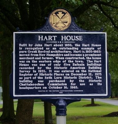
Hart House Marker
GEOGRAPHIC SORT Title Sort Marker Number Sort Marker Number Sort for Trails Publication Order Sort Publication Order Sort A Erected Year Sort Most Viewed Sort Most Recent-Interest Sort Most Recently Changed Sort SEE FAQ #33 FOR DESCRIPTIONS
On North Eufaula Avenue (U.S. 431) 0.1 miles north of Broad Street, in the median.
On Parmer Street at Oglesby Street, on the right when traveling east on Parmer Street.
Near County Road 267 0.8 miles north of County Road 216, on the left when traveling north.
On U.S. Highway 84 (U.S. 84) 1.9 miles west of Lena Landegger Highway (County Road 39), on the right when traveling west.
On East 34th Street north of East 14th Avenue, on the right when traveling north.
On East 4th Street at North Broad Street, on the right when traveling east on East 4th Street.
On South Cave Street at East 7th Street, on the right when traveling north on South Cave Street.
On Historical Central Street at Tisdale Street, on the right when traveling east on Historical Central Street.
Near County Road 1043 west of County Road 1117, on the right when traveling north.
On Tremont Street, on the right when traveling south.
On Main Street 0.1 miles south of Alabama Route 14, on the right when traveling north.
On North St. Andrews Street, on the left when traveling north.
On 7th Avenue North west of 24th Street North, on the right when traveling west.
On East Ervine Avenue at North Court Street, on the right when traveling west on East Ervine Avenue.
Paid Advertisement
Near Riverview Drive at Grove Street, on the right when traveling east.
On Avenue A just south of South 7th Street, on the left when traveling south.
On South 9th Street south of Avenue A, on the right when traveling south.
Near Spring Villa Road (County Road 148) 1.5 miles east of State Highway 169, on the right when traveling east.
On Maysville Road Northeast north of Humes Avenue Northeast, on the right when traveling north.
On U.S. 80, on the right when traveling east.
On Oakleigh Place at Savannah Street, on the left when traveling north on Oakleigh Place.
On Superintendents Drive at Coy Smith Highway (Alabama Route 96), on the right when traveling west on Superintendents Drive.
On Robbins Street (County Road 50) north of Wheeler Street, on the right when traveling north.
On South Union Street north of Grove Street, on the left when traveling north.
On North Uchee Road (County Road 22) 1 mile east of Walker Road (County Road 2), on the right when traveling east.
On Cushman Street, on the left when traveling north.
On Cushman Street at 3rd Avenue, on the left when traveling north on Cushman Street.
On 1st Avenue at Cowles Street, on the left when traveling west on 1st Avenue.
Paid Advertisement
On Cowles Street at 5th Avenue, on the right when traveling south on Cowles Street.
On Cushman Street at 5th Avenue, on the left when traveling north on Cushman Street.
On Cowles Street at 5th Avenue, on the left when traveling south on Cowles Street.
On Cushman Street south of Illinois Street, on the right when traveling north.
On East Elmwood Avenue east of South Valley Way, on the left when traveling east.
On Harbor Drive (Local Route F-99) south of Lincoln Street, on the left when traveling south.
On Katlian Street at Lincoln Street, on the right when traveling north on Katlian Street.
On Historic Route 66 (U.S. 180) at North Leroux Street, on the right when traveling west on Historic Route 66.
On West Aspen Avenue at North Sitgreaves Street, on the left when traveling west on West Aspen Avenue.
On East Route 66 (U.S. 180) 0.1 miles east of North Park Drive, on the left when traveling east.
On West Route 66 (Business Interstate 40) at West Riordan Road, on the right when traveling east on West Route 66.
Near Village Loop Drive 0.4 miles west of El Tovar Road, on the right when traveling west.
On El Tovar Road 0.1 miles north of Village Loop Drive, on the right when traveling west.
On East Bill Williams Avenue (U.S. 66) east of South Taber Street, on the right when traveling east.
On Historic Route 66 at South 2nd Street, on the right when traveling east on Historic Route 66.
On Historic Route 66 east of North 3rd Street, on the left when traveling east.
Paid Advertisement
On West Grant Avenue at South 6th Street, on the right when traveling west on West Grant Avenue.
On Historic Route 66 east of North 3rd Street, on the left when traveling east.
On West Sherman Avenue at South 2nd Street, on the left when traveling west on West Sherman Avenue.
Near Cemetery Street (Business U.S. 10) 0.1 miles north of West Main Street (U.S. 95) when traveling north.
On Hopi Drive (U.S. 180) east of 2nd Avenue, on the right when traveling east.
On Hopi Drive at 7th Avenue, on the right when traveling east on Hopi Drive.
On Main Street at the Downtown Trail, on the right when traveling south on Main Street.
Near East Van Buren (U.S. 62) just west of County Road 205, on the right when traveling west.
On Clay Street at South 4th Street, on the right when traveling west on Clay Street.
On Caddo Street at North 16th Street, on the right when traveling west on Caddo Street.
On Main Street at South 12th Street, on the right when traveling east on Main Street.
On Meador Lane north of Cherry Street, on the right when traveling north.
On North 1st Street at West Main Street (Arkansas Route 53), on the left when traveling north on North 1st Street.
On East Cherry Street at North 9th Street, on the left when traveling east on East Cherry Street.
Near Heritage Park Road east of North 11th Avenue, on the right when traveling east.
On North 10th Avenue at West Cherry Street, on the left when traveling north on North 10th Avenue.
Paid Advertisement
On Bold Pilgrim Road 0.3 miles west of Arkansas Highway 9, on the left when traveling west.
On Arkansas Route 9 at Bold Pilgrim Road, on the right when traveling south on Arkansas Route 9.
On West Church Street (State Road 113) at South Division Street, on the right when traveling east on West Church Street.
On Green Street west of South Baramore Street, on the right when traveling west.
On North Morrill Street at West Higgins Street, on the right when traveling south on North Morrill Street.
On Main Street east of South 3rd Street, on the right when traveling east.
On Drennen Street at South 6th Street, on the right when traveling east on Drennen Street.
On Locust Avenue at Scott Street, on the right when traveling south on Locust Avenue.
On West Main at Franklin, on the left when traveling east on West Main.
On North Roseville Street south of Smitherman Street, on the right when traveling south.
On South 2nd Street north of West Main Street, on the right when traveling north.
On East River Street at South 1st Street, on the right when traveling east on East River Street.
On Central Avenue (State Highway 7) 0.1 miles north of Canyon Court, on the right when traveling north.
On Oak Street just north of Orange Street, on the right when traveling north.
On Park Avenue (State Highway 7) just west of Bloom Street, on the right when traveling south.
On Orange Street just west of Central Avenue (State Highway 7), on the left when traveling west.
Paid Advertisement
On Central Avenue (State Highway 7) at Market Street, on the right when traveling south on Central Avenue.
On Ouachita Avenue just west of Hawthorne Street, on the left when traveling west.
On Convention Boulevard just west of Malvern Avenue, on the right when traveling east.
On Orange Street at Woodbine Street, on the right when traveling west on Orange Street.
On Quapaw Avenue just east of Fern Street, on the left when traveling east.
On Quapaw Avenue at Fern Street, on the right when traveling west on Quapaw Avenue.
On Central Avenue (State Highway 7) at Chapel Street, on the right when traveling north on Central Avenue.
On Church Street just east of Cottage Street, on the left when traveling east.
On Central Avenue (State Highway 7) just north of Fountain Street, on the right when traveling north.
On Prospect Avenue at Hawthorne Lane, on the right when traveling west on Prospect Avenue.
On Quapaw Avenue just west of Violet Street, on the left when traveling west.
On Cemetery Drive 0.2 miles west of Martin Luther King Boulevard (Business U.S. 270).
On West Main Street at North Central Avenue, on the right when traveling west on West Main Street. Reported missing.
On West 2nd Avenue at South Pine Street, on the left when traveling west on West 2nd Avenue.
On South Grandview Avenue at East Main Street, on the left when traveling south on South Grandview Avenue.
On South Grandview Avenue 0.1 miles north of East Poplar Street, on the right when traveling north.
Paid Advertisement
On South Jefferson Street at West Bradley Street, on the left when traveling south on South Jefferson Street.
On West Bradley Street just east of South Jefferson Street, on the right when traveling east.
On West Bradley Street east of South Jefferson Street, on the right when traveling east.
On Front Street Southwest (U.S. 70) west of South Center Street, on the right when traveling east.
On Front Street Northwest at Park Street when traveling east on Front Street Northwest.
︽
3998 entries matched your criteria. The first 100 are listed above.
Next 100 ⊳