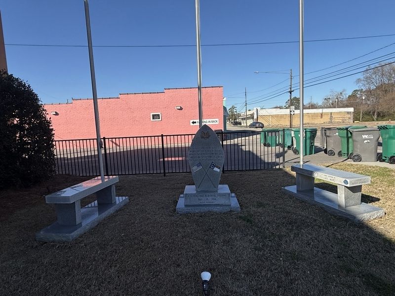
On Main Street (North Carolina Route 242) at Seaboard Street (Route 211), on the right when traveling south on Main Street.
A dedication to our fallen warriors and the men and women who have served and are currently serving our country in the armed forces
N. C. Flag Day Memorial Festival
May 28, 1994 — — Map (db m291900) WM
On Main Street (State Highway 131) at Seaboard Street (State Highway 211), on the right on Main Street.
In 1953, the small town of Bladenboro was terrorized by mysterious cat-like creature that attacked local animals draining their blood. — — Map (db m291722) HM
On North College Street (Business U.S. 701) at Mercer Mill - Brown Marsh Road, in the median on North College Street.
Organized prior to 1756. Present building constructed 1818—the third on site. First two buildings of logs. Was also used for secular education until 1848. Among early ministers: H. McAden, Jas. Hall, S. Stanford, C. Lindsay. — — Map (db m60483) HM
On Mercer Mill - Brown Marsh Road just south of Lisbon Road, on the right when traveling north.
Organized prior to 1756 by Scottish settlers. Present building constructed 1818. Third building on site. First two building of logs. Was also used for secular education until 1848. Some early ministers: H. McAden — Jas. Hall — S. Stanford — C. . . . — — Map (db m60485) HM
On North College Street (Business U.S. 701) at Burney Ford Road, on the left when traveling south on North College Street.
Anna Mathilda McNeill Whistler, mother of the noted painter, James Abbot McNeill Whistler, lived in a house which stood 1300 yards east of this spot. — — Map (db m60280) HM
On State Highway 87 at Lisbon Road, on the left when traveling north on State Highway 87.
Mount Horeb
Presbyterian Church
and Cemetery
circa 1845
have been placed on the
National Register
of Historic Places
by the United States
Department of the Interior — — Map (db m215473) HM
On Elwell Ferry Road (County Route 1730) at Highway 87, on the right when traveling east on Elwell Ferry Road.
One and one-half miles northeast stands Oakland, the home
of General Thomas Brown, an officer of the Revolution, 1747-1814. Staunch patriot, statesman, planter. — — Map (db m215474) HM
On North Carolina Route 87 0.3 miles north of Grimsley Road, on the left when traveling north.
Two hundred feet south west, stands Carvers Creek Methodist Church, birthplace of Methodism in Bladen County. The Methodist movement here was organized by Bishop Francis Asbury during the last years of the eighteenth century. — — Map (db m275331) HM
On North Carolina Route 87 0.3 miles north of Grimsley Road, on the left when traveling north.
Quakers settled and worshiped here prior to the Revolutionary War. Their religious convictions against war and slavery resulted in hostility toward their faith which influenced them to move into other Quaker communities. An unknown number are buried . . . — — Map (db m275333) HM
On State Highway 210 at Old Whitehall Road, on the left when traveling north on State Highway 210.
In Memory of
Lt. Richard G. Shipley
Age 23, Fresno. Cal.
Lt. Howard R. Johnson, Jr
Age 23, Sheffield. Tex.
Sgt. Robert M. Anderson
Age 23 San Ysidro, Cal.
Sgt. Roger H. Knowlton
Age 22. Rochester, N.Y.
Troop Carrier Command of . . . — — Map (db m94360) HM WM
On State Highway 87 just east of State Highway 131, on the right when traveling west.
Colonel in Revolution, member of provincial congresses and state senator. Robeson County is named for him. His home stood ½ mile N.E. — — Map (db m222331) HM
On Staion House Way north of Chicamacomico Way, on the right when traveling north.
An underwater labyrinth of sandbars stretches for 20 miles into the Atlantic Ocean, varying in depth from 3 to 15 feet, causing frequent shipwrecks. One of North Carolina's three great capes, collectively known as the Graveyard of the Atlantic, . . . — — Map (db m115691) HM
On Federal Road at Capt Charlies Point Road, on the right when traveling south on Federal Road.
The Cape Fear Lighthouse stood here until it was deactivated and replaced by the Oak Island lighthouse across the mouth of the river. The wrought iron and steel frame of the tower stood 150 feet high and its flashing lens was capable of reaching an . . . — — Map (db m115767) HM
On Federal Road at Capt Charlies Point Road, on the right when traveling south on Federal Road.
These four dwellings were provided by the government for the keepers of the Cape Fear Lighthouse and their families. Captain Charles Swan, the first keeper of the light, lived with his family and staff in these homes from 1903 until 1933. The . . . — — Map (db m115702) HM
On South Bald Head Wynd 0.1 miles south of Salt Meadow Trail, on the right when traveling south.
Union ships chased the blockade runner Ella ashore on Bald Head Island as she tried to enter Old Inlet on December 3, 1864. Over the following two days, Confederate soldiers from Fort Holmes salvaged goods from the derelict vessel before she . . . — — Map (db m165876) HM
On West Bald Head Wynd at Cape Fear Trail, on the left when traveling south on West Bald Head Wynd.
A rectangular sand bastion, Battery No. 2 mounted a 100-pounder Brooke Cannon and was located about 200 yards east. The site of circular-shaped Battery No. 1 with its 10-inch Columbiad cannon is about 100 yards to the west. It sat upon the south end . . . — — Map (db m165878) HM
On West Bald Head Wynd at Sea Gull Trail, on the right when traveling south on West Bald Head Wynd.
Fort Holmes’s largest earthen battery was built on the southwestern elbow of Bald Head Island to guard Old Inlet for blockade running ships. Its seacoast cannon provided cross-fire with Fort Caswell on Oak Island. Erosion claimed Battery Holmes by . . . — — Map (db m115743) HM
On Light House Wynd at North Bald Head Wynd, on the left when traveling north on Light House Wynd.
Battery No. 4 highlights what remains of Fort Holmes. This crescent-shaped sand bastion mounted two 24-pounder and two 32-pounder cannon to guard against an enemy attack from the direction of East Beach and Bald Head Creek. The battery and a large . . . — — Map (db m115759) HM
On Ballast Stone Ally east of North Bald Head Wynd, on the right when traveling east.
In this area stood the main base camp for Fort Holmes’s garrison troops, and the headquarters of Colonel John J. Hedrick, 40th Regiment NC Troops. The barracks and storehouses were made largely of red cedar lumber and shingles, hewed from Bald Head . . . — — Map (db m115745) HM
This brick structure was built to house the generator for the Cape Fear Lighthouse. A slate roof covers brick walls that are approximately 10-1/2 inches thick. — — Map (db m115696) HM
On Light House Wynd north of North Bald Head Wynd, on the left when traveling north.
Wilmington, North Carolina was the Confederacy's most important Seaport during the Civil War. By 1864, it was the last Atlantic Port open to trade with the outside world. General Robert E. Lee said: “If Wilmington falls, I cannot maintain . . . — — Map (db m165877) HM
On Light House Wynd at Ballast Stone Alley, on the left when traveling west on Light House Wynd.
British troops constructed Fort George to defend Bald Head Island and their warships’ anchorage at the mouth of the Cape Fear River. American forces attacked the fort, but were repulsed, in early September 1776. This was believed to be the first . . . — — Map (db m115744) HM
On Station House Way north of Chicamacomico Way, on the left when traveling south.
U.S.S. Peterhoff served on the Union blockade of the Cape Fear until it was accidentally run into and sunk by the U.S.S. Monticello on March 7, 1864 off bald Head Island’s East Beach. The Peterhoff’s remains are located about . . . — — Map (db m115693) HM
On River Road SE (State Highway 133) south of U.S. 17, on the right when traveling south.
Associate Justice United States Supreme Court, 1799–1804, officer in the Revolution, state Attorney General, Judge. Home was 18¾ mi. S. — — Map (db m215669) HM
On River Road SE (U.S. 133) south of Route 17, on the right when traveling south.
Large Confederate fort stands 13 mi. S. After a strong Union attack it was evacuated Feb. 18, 1865, resulting in the fall of Wilmington. — — Map (db m6437) HM
Erected by Captain John Russell, Commander of His Britannic Majesty's Sloop of War Scorpion, who gave his name to this residence and tract of fifty-five acres of land adjacent to the town of Brunswick. Subsequently owned and occupied by the . . . — — Map (db m22372) HM
Commissioners met here to run boundary in 1764. Popular stop for colonial travelers. Ruins used to establish present state line in 1928. Located 2¾ mi. S.E. — — Map (db m5375) HM
On U.S. 17 near the South Carolina line, on the right when traveling north.
The road from New England to Charleston, over which mail was first carried regularly in North Carolina, 1738–39, passed near this spot. — — Map (db m6317) HM
On U.S. 17 0.4 miles south of Boundaryline Drive NW, on the right when traveling north.
South Carolina. Formed in 1712 from part of Carolina, which was chartered in 1663, it was first settled by the English in 1670. One of the 13 original states.
North Carolina. Colonized, 1585-87, b first English settlers in America; . . . — — Map (db m39649) HM
Near Caswell Beach Road 2.5 miles east of Oceangreens Lane.
1826: Construction Begins
Remainder of text unreadable.
1833: The Fort is Named
Remainder of text unreadable.
1836: A New Leader
Remainder of text unreadable.
1838: Project is Finished . . . — — Map (db m267419) HM
Near Caswell Beach Road 2.4 miles east of Oceangreens Lane, on the right when traveling east.
Part of a Remarkable System: Third System Forts and the War
Following the American Revolution, military and civil leaders were keenly aware that U.S. seacoast defense was weak, but struggled to act. The United State did not yet have the . . . — — Map (db m267442) HM
Near Caswell Beach Road 2.5 miles east of Oceangreens Lane, on the right when traveling east.
The artillery pieces kept at Fort Caswell during the Civil War changed over time during the war. What was here depended on what was available, and what was needed at different locations, with some pieces being exchanged between defensive points . . . — — Map (db m267443) HM
On Country Club Road (State Highway 133) at Yaupon Drive, on the right when traveling south on Country Club Road.
Seized by N.C. Militia three months before firing on Fort Sumter. Governor Ellis ordered its return to Federal Authority; three miles east. — — Map (db m5834) HM
On Country Club Drive (State Highway 133) south of Yaupon Way, on the left when traveling south.
Category 4 storm made landfall at Long Beach, October 15, 1954, with winds over 140 mph & 17-foot surge. Nineteen people killed in N.C. — — Map (db m5832) HM
On Main Street (Business U.S. 17) south of Mulberry Street, on the right when traveling north.
Established late 1700’s. Incorporated March6, 1899. The Shallotte River was navigated by commercial sailing vessels until the 1920’s when the roads were built. First church building erected on this site circa 1799. — — Map (db m28823) HM
On Plantation Road north of Plantation Road, on the left when traveling south.
Founded c. 1725, long a principal port of N.C., site of Spanish attack, 1748, and of Stamp Act resistance, 1766. Later abandoned. Was 2 mi. S.E. — — Map (db m6451) HM
On River Road SE (U.S. 133) just north of Plantation Road, on the right when traveling south.
A Spanish expedition captured the town of Brunswick, 1748, during King George’s War, but was soon driven away by the colonial militia. — — Map (db m6420) HM
On South Davis Street at East Bay Street, on the right when traveling north on South Davis Street.
Here on this small bluff overlooking the Cape Fear River, Joshua Potts in the year 1790 envisioned a town surrounding old Fort Johnston. “Braced up by the effects of the salubrious breeze, from the sea,” Joshua Potts laid out the first . . . — — Map (db m4792) HM
On East Bay Street near South Howe Street, on the right when traveling east.
Dedicated to the memory of Catalino Tingzon, interred in Northwood Cemetery, and all Merchant Marine seamen and U.S. Navy Armed Guard on the tanker S.S.John D. Gill torpedoed and sunk off Cape Fear by the German submarine U-158 . . . — — Map (db m4950) HM
Near Ferry Road SE (State Highway 211) 0.3 miles east of East Moore Street.
During the war of 1812, North Carolina Governor William Hawkins called up companies of militia from Brunswick, Bladen, New Hanover and Duplin counties for the coastal defense of the state against British invasion to serve at Fort Johnston in . . . — — Map (db m115792) HM
On Southport-Supply Road (State Highway 211) at Long Beach Road (State Highway 133), on the left when traveling east on Southport-Supply Road. Reported missing.
Named for Gov. Caswell. Begun by U.S. in 1826; seized by N.C. troops, 1861; abandoned by Confederates, 1865. Stands five miles southeast. — — Map (db m16331) HM
On East Bay Street east of South Davis Street, on the left when traveling east.
This tablet was erected May, 1911 by the North Carolina Society of Colonial Dames of America to mark the site of Fort Johnston, the first fort in the Province of North Carolina, built under Act of Assembly of 1745 and completed 1764, and named in . . . — — Map (db m4754) HM
On East Bay Street east of South Davis Street, on the left when traveling east.
On January 9, 1861, as secession fever swept the South, an armed body of civilians overwhelmed Fort Johnston’s lone occupant, Ordinance Sgt. James Reilly, and demanded the keys. Reilly quickly surrendered them and received a receipt in return. . . . — — Map (db m168569) HM
Site for this public park was given to the town of Smithville, which was named in his honor, by Governor Benjamin Smith. His legacy provided that land in this square be used for educational, fraternal, religious and recreational purposes.
Th . . . — — Map (db m5988) HM
On West Moore Street at South Lord Street, on the right when traveling east on West Moore Street.
This ancient gnarled oak has been estimated to be more than 800 years old. Indians may have bent the young tree to mark the trail to their fishing grounds. The tree took root a second time, thus developing the unusual formation. — — Map (db m20366) HM
On East Bay Street east of South Davis Street, on the left when traveling east.
Last royal governor of North Carolina, 1771–75. Fearing capture, in June 1775 he sought refuge here. Fled offshore to HMS Cruizer in July. — — Map (db m4790) HM
Erected April 13th, 1938
by the
National Society United States Daughters of 1812
of
North Carolina
A memorial to North Carolina Militia, stationed at Deepwater Point, about one mile north-east of Southport on the water front. Several . . . — — Map (db m272681) WM
On South Davis Street at East Bay Street, on the right when traveling north on South Davis Street.
Erected during North Carolina’s Tercentenary to Mrs. Jessie Stevens Taylor, 1879–1961. She loved her God, Country and fellow man. She served here as a Voluntary Weather Observer and Storm Warning Display Woman from 1900 to 1961. — — Map (db m4752) HM
On February 27, 1904, ground was broken for the “new” jail. Contractor A.J. Robbins received the contract with a low bid of $6,738. Its construction is “a concrete foundation with brick walls, laid in 1:6 bond constructed with a six-course belt and . . . — — Map (db m6095) HM
On Rhett Street at Nash Street, on the right when traveling north on Rhett Street.
Between the Civil War and the construction of the Panama Canal in 1904, local residents and investors desperately sought to surpass Wilmington by building a rail link to the Appalachian coal fields. Smithville would become the first refueling stop . . . — — Map (db m6227) HM
On N. Lord Street at W. Nash Street, on the right when traveling south on N. Lord Street.
1915–1965, columnist and author. “The Old Man and the Boy,” were youthful remembrances of his material grandfather, Captain Edward Atkins, in this house. — — Map (db m4800) HM
On River Road Southeast (North Carolina Route 133) 0.2 miles north of George II Highway Southeast ( Route 87), on the left when traveling north.
Maj. Gen. Howe was the
commander of Southern
Dept. of the Continental
Line, 1776-78, & N.C.'s
highest ranking officer.
Lived 4½ miles east. — — Map (db m267525) HM
On Rhett Street north of Monroe Street, on the right when traveling north.
“Nor even this hour shall want its charm / For side-by-side still fondly we’ll keep / And calmly in each others arms / Together linked go down the deep.” —From the marker for Emeline L. Taylor and Major George Taylor who were swept from the . . . — — Map (db m6229) HM
On East Nash Street west of Howe Street ( Highway 211), on the right when traveling west.
January 1916. Founded in 1893, the Southport Volunteer Fire Department was officially organized with the election of officers and adoption of a constitution and by laws on 21 January, 1916. Authorized purchase of the city’s first fire alarm bell . . . — — Map (db m5996) HM
On Ferry Road (State Highway 211) at the Deep Point Marina exit road, on the left when traveling east on Ferry Road.
Barbadian planter turned pirate made North Carolina his base, 1718. Captured in naval battle few miles east. Hanged in Charleston. — — Map (db m101979) HM
Thanks for our freedom
This Memorial, dedicated on November 11, 2015, and funded by private donations, honors the Men and Women Who Have Served Our Nation.
It was made possible through the heart, vision, dedication, and tireless efforts . . . — — Map (db m105916) WM
Near St Phillips Road SE 0.6 miles east of Plantation Road, on the left when traveling east.
This is a reproduction 32-pounder cannon, 'similar to those at Fort Anderson during the Civil War. It is a Pattern 1846 gun. The term "32-pounder" refers to the weight of the iron shot it fired.
In April 1861, when the U. S. Navy abandoned the . . . — — Map (db m284181) HM
Near St Phillips Road SE 0.6 miles east of Plantation Road, on the right when traveling south.
Brunswick homes were similar in style to those built in the West Indies or Caribbean. The main structure on this lot was quite impressive, measuring about 22 feet by 29 feet with a 10-foot-wide porch across the front. There were also several . . . — — Map (db m284501) HM
On St. Philips Road east of River Road ( Highway 133).
Brunswick Town State Historic Site was established on land donated to the State of North Carolina in December, 1952, by James Laurence Sprunt and his four sons, James Laurence Sprunt, Jr., Kenneth Murchison Sprunt, Samuel Nash Sprunt, and Laurence . . . — — Map (db m5535) HM
When Maurice Moore planned Brunswick in 1725, conflict between England and Spain was imminent. The War of Jenkins' Ear, later King George's War, began in 1739. As the war progressed, Spaniards began attacking English settlements up the Cape Fear . . . — — Map (db m284504) HM
A memorial to Colonel Maurice Moore, gentleman and soldier of the King, who in the year of our lord 1725 founded in a wilderness The Town of Brunswick reserving for the glory of God the tract of land on which was built this parish church . . . — — Map (db m6510) HM
Begun 1861. Named in honor of General Joseph R. Anderson, then commanding military district.
The Fort, under command of Brig. Gen. Johnson Hagood, suffered a severe bombardment by a Federal fleet and attack by Federal army under Maj. Gen. J. M. . . . — — Map (db m6494) HM
Near St. Philips Road SE 0.6 miles east of Plantation Road when traveling east.
In 1861–1862, Col. William Lamb and Maj. John Hedrick constructed Fort Anderson, one of several Confederate strongholds that protected Wilmington, a major blockade-running port. They enlarged Fort St. Philip (for St. Philip’s Anglican Church on your . . . — — Map (db m284189) HM
On River Road SE (State Highway 133) at Plantation Road (Local Road 1529), on the left when traveling south on River Road SE.
Large Confederate fort stands 2 mi. E. After a strong Union attack it was evacuated Feb. 18, 1865, resulting in the fall of Wilmington. — — Map (db m6438) HM
On St. Philips Road at Plantation Road on St. Philips Road.
Ordained 1707; came to America 1708. Served in many churches in area as missionary of Society for the Propagation of the Gospel, 1732–1755. — — Map (db m6483) HM
Near St Phillips Road SE 0.6 miles east of Plantation Road, on the right when traveling east.
"Janet Schaw, visiting Carolina in 1775, found there much that was not to her liking but the women she regarded with admiration."
Julia Cherry Spruill, Women's Life and Work in the Southern Colonies p.64
Margaret . . . — — Map (db m284643) HM
On Plantation Road 0.1 miles east of River Road (Route 133), on the left when traveling south.
House built c. 1725, subsequent additions. Home first of Roger Moore, later of Gov. Benjamin Smith, still later of James Sprunt. ¾ mi. E. — — Map (db m167688) HM
On River Road (State Highway 133) at Plantation Road, on the left when traveling south on River Road.
Anglican, built under act of 1751. Graves of Governors Arthur Dobbs and Benjamin Smith and U.S. Justice Alfred Moore. Ruins 2 mi. S.E. — — Map (db m6467) HM
Near St Phillips Road SE 0.6 miles east of Plantation Road, on the right when traveling south.
Twelve graves were found beneath the floor of the church, most concentrated near the altar. Important people were buried inside the church as a sign of status.
Archaeology has revealed eight large footings in the church which supported the . . . — — Map (db m284492) HM
Near St Phillips Road SE 0.6 miles east of Plantation Road SE when traveling east.
Fort Anderson contained two main batteries that could mount ten seacoast guns. Battery A is parallel to the river channel. Its 32-pounder guns could fire directly into ships trying to sail up river. Battery B could defend against both land and . . . — — Map (db m284187) HM
Near St Phillips Road SE 0.6 miles east of Plantation Road SE, on the left when traveling east.
Fixed fortifications located on waterways were difficult to properly defend against steam-driven warships. Ideally, they relied on heavy cannons and naval vessels for protection. However, the Confederacy lacked the industrial capacity to . . . — — Map (db m284433) HM
On State Highway 343 0.2 miles north of U.S. 158, on the left when traveling north.
Built in 1847, the historic Camden County Courthouse was listed on the National Register of Historic Places in 1973. "A jewel among the state's Greek Revival buildings," the two-story building with hip roof and five-bay main facade replaced a . . . — — Map (db m57038) HM