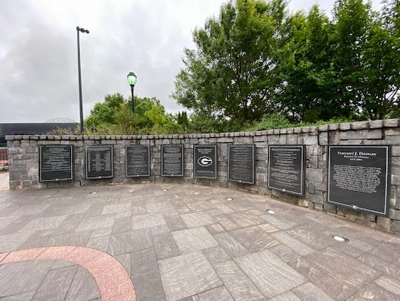
He developed and led a sports program that produced 23 national team championships, 78 Southeastern Conference crowns, and Bulldog student-athletes won 98 individual national titles.
Year• Team• Coach
1980•Football•Vince Dooley
1985•Men's . . . — — Map (db m221590) HM
On Cemetery Avenue 0.2 miles east of East Campus Drive, on the right when traveling east.
Oconee Hill Cemetery was purchased in 1855 by the City of Athens when further burials were prohibited in the old town cemetery on land owned by The University of Georgia. In 1856, the City formed a self-perpetuating Board of Trustees to hold and . . . — — Map (db m38875) HM
Near South Poplar Street north of Oak Street, on the left when traveling north.
Run -off water from the upper piedmont forms the Oconee (a Native American word meaning "river").
Below the Appalachian Mountains of North Georgia, the Oconee River headwaters begin in the rolling hill country of Hall and Gwinnett Counties . . . — — Map (db m207633) HM
On South Jackson Street 0.1 miles north of Baldwin Street, on the right when traveling north.
This site is the original burial ground for Athens and contains the remains of its earliest citizens. It is a part of the original tract of land purchased for The University of Georgia by Governor John Milledge in 1801. All people in Athens were . . . — — Map (db m19707) HM
On South Jackson Street 0.1 miles north of Baldwin Street, on the right when traveling north.
Old Athens Cemetery
ca. 1810
This property has been
placed on the
National Register
of Historic Places
by the United States
Department of the Interior — — Map (db m200700) HM
Near East Broad Street (U.S. 78) 0 miles west of South Jackson Street.
Built in 1806 by Jett Thomas to the specifications of college president Josiah Meigs, Old College was the first permanent building on the University of Georgia campus. Originally named Franklin College in honor of Benjamin Franklin, the building . . . — — Map (db m19515) HM
On South Lumpkin Street north of Carlton Street, on the right when traveling north.
Here passed the Old Indian Trail used by the Creeks of the Savannah River basin, the Cherokees of upper Georgia and Tennessee and by trading parties of other tribes. — — Map (db m198448) HM
On North Thomas Street at East Washington Street, on the right when traveling north on North Thomas Street.
In summer 1996, Athens, Georgia, shone as the largest Olympic venue site outside Atlanta, as the state hosted the Centennial Olympic Games July 19 - August 4. Some 650,000 visitors bought tickets to events at three University of Georgia venues: . . . — — Map (db m11870) HM
Near South Lumpkin Street at Baxter Street, on the left when traveling south.
The Omega Psi Phi Fraternity, Incorporated, was founded Friday, November 17, 1911, on the campus of Howard University, Washington, D.C., by four men on the principles of Manhood,
Scholarship, Perseverance, and Uplift. "Friendship is essential to . . . — — Map (db m214482) HM
On Oconee Street, on the left when traveling east.
This bell was purchased for and hung in the original Oconee Street Methodist Episcopal Church, South, located at 142 Oconee Street. It is the first known item to represent the church in the Athens community, arriving in August 1870, before the . . . — — Map (db m207853) HM
Near State Street at Hoyt Street, on the right when traveling north.
Origins of Formal Parterre Gardens Formal gardens originated in France in the 1400s and reached their peak in Europe in the 1600s. They were originally a way for the rich to display their wealth and status.
The “parterre” garden is a type of . . . — — Map (db m199962) HM
Named in honor of Captain Richard P. Pawson, SC, USN (Ret.) who constructed this garden from a drawing by Mrs. Mary Alice Donley
Although Captain Pawson retired after nearly
33 years of active naval duty , he continued his service to the . . . — — Map (db m198505) HM
Near South Jackson Street north of Baldwin Street, on the right when traveling north.
These two engraved 'petroglyphic' boulders were carved by prehistoric Native Americans of Georgia. Their exact ages are unknown but the symbols are somewhat similar to Georgia pottery designs from ca. 800 years ago. The meaning of the symbols is . . . — — Map (db m198832) HM
Near South Lumpkin Street at Baxter Street, on the left when traveling south.
Phi Beta Sigma Fraternity. Incorporated, was founded on January 9, 1914, on the campus of Howard University in Washington, D.C., by three honorable men who ensured the fraternity would live out the motto. "Culture for service, service for humanity." . . . — — Map (db m214483) HM
•Increased capacity of Sanford Stadium
from 36,000 to 92,746
•Sanford Stadium Double Decked 1967, East End Zone 1981, West End Zone 1991, South Suites 1994, South Suites Addition and Sky Club 2000, Gate 6 2002, North Side Upper Deck 2003, North . . . — — Map (db m221591) HM
On Gran Ellen Drive, on the left when traveling west.
Dedicated to the recipients of this nation's oldest military decoration "The Purple Heart"
Military Order of the Purple Heart, 1782/1932.
“My stone is red for
the blood they shed.
The medal I bear
is my country's way
to show . . . — — Map (db m221694) WM
This Public Service Complex is named to
honor R. Chappelle Matthews (1908-1986) who
served in the Georgia House of Representatives
for twenty eight (28) years representing the
district that included the University of Georgia.
Representative . . . — — Map (db m198557) HM
Near East Broad Street east of Mulberry Street, on the left when traveling east.
Georgia Railroad was located off Broad St, to the east of Foundry St. and lease factory space to the Hanna Manufacturing Baseball Bat Co.
1833 Georgia Railroad Co. is incorporated by a group of Athens citizens led by James Camak.
1841 . . . — — Map (db m207369) HM
Near East Broad Street west of Mulberry Street, on the left when traveling west.
Seaboard Air Line Railway operated Athens' passenger service to Atlanta and the Northeast from its station on the corner of College and Ware St.
1892 Georgia, Carolina & Northern Railway is built and connects Charlotte, NC, Athens, and Atlanta. . . . — — Map (db m207610) HM
Near East Broad Street east of Mulberry Street, on the left when traveling east.
Central of Georgia Railway station and yard was located on the corner of Thomas and Mitchell St. It was destroyed by fire in 1980.
1835 Central of Georgia Railroad begins construction in Savannah.
1889 Macon & Northern Railroad completes . . . — — Map (db m207612) HM
Near East Broad Street east of Mulberry Street, on the left when traveling east.
Gainesville Midland Railway and Seaboard Air Line Railway shared a station on the corner of Ware St. and College Ave. They also shared a terminal on the corner of Foundry St. and Broad St.
1904 The Gainesville Midland Railway (GM) is chartered . . . — — Map (db m207614) HM
Near East Broad Street east of Mulberry Street, on the left when traveling east.
The 1913 Southern Railway station was located at the corner of Hoyt St. and Hull St. Service to this station was discontinued in 1970.
1870 Northeastern Railroad of Georgia is chartered to build a railroad from Athens northward.
1876 . . . — — Map (db m207615) HM
Near East Broad Street west of Mulberry Street, on the left when traveling west.
In the late 1800s, rail lines were extended into the eastern part of downtown Athens, creating a warehouse district.
Athens businesses no longer depended on the North Oconee River and wagons for transportation, and a bustling warehouse district . . . — — Map (db m207616) HM
Near East Broad Street west of Mulberry Street, on the left when traveling west.
In the years between the Civil War and 1920, cotton was the principal crop in the countryside surrounding Athens. Virtually every available acre was dedicated to its' production.
In 1910, the Athens Banner newspaper declared that Athens . . . — — Map (db m207619) HM
Near Oconee Street (Business U.S. 78) 0.4 miles west of South Poplar Street, on the right when traveling west.
The construction of the Seaboard Air Line Railway main line into Athens made this area a destination for national touring companies and famous personalities.
Rail connected Athens to all parts of the country, allowing culture and . . . — — Map (db m207620) HM
Near East Broad Street west of Mulberry Street, on the left when traveling west.
In the early 1900s, cotton was still Athens' main economic engine, but other businesses and industries began to make a major impact.
Everything from baseball to soft drinks to airplanes were produced locally. Businesses included Bludwine, . . . — — Map (db m207621) HM
On Willow Street at Hickory Street, on the right when traveling north on Willow Street.
The wooded hill on the horizon to your right is the site of the Cook & Brother Gun Emplacement - one of Athens' last lines of defense against invading forces.
The only attempt to invade Athens during the Civil War was by the Union forces of . . . — — Map (db m296514) HM
Near East Broad Street east of Wilkerson Street, on the right.
Built around 1885, a wooden covered bridge connected the mill community of Potterytown to the Check Factory textile mill.
On this site the mill bridge brought East Broad Street to the front door of the mill. By 1909, this bridge was replaced . . . — — Map (db m207642) HM
Near East Broad Street east of Wilkerson Street, on the right when traveling east.
Mills were located at shoals in the river where water dropped quickly, providing power for manufacturing. Clarke County had 19 mills, and many were located on the Athens riverfront.
A dam constructed in the 1830s on the rocky shoals downstream. . . . — — Map (db m207644) HM
Near East Broad Street east of Wilkerson Street, on the right when traveling east.
Throughout history our rivers have been used and abused. Conservation enhances the valuable uses of our river, and protects the plant and animals of our river community.
Our rivers are brown because of poor farming and construction practices . . . — — Map (db m207646) HM
Near East Broad Street (State Road 10 / 78) at Herty Street, on the left when traveling south.
A majestic oak tree once stood on this spot and one of the University's most endearing legends also flourished here. Robert Toombs (1810-1885) was young, and boisterous when he was dismissed from Franklin College in 1828. Five decades later it . . . — — Map (db m11966) HM
On Pulaski Street at West Washington Street, on the right when traveling south on Pulaski Street.
[First plaque]
This property has been
placed on the
National Register
of Historic Places
by the United States
Department of the Interior
[Second plaque]
This structure has been
recorded by the
Historic American . . . — — Map (db m199975) HM
Near South Lumpkin Street at Baxter Street, on the left when traveling south.
Sigma Gamma Rho Sorority Incorporated, was founded on November 12, 1922, on the campus of Butler University by seven trailblazing educators uplifting and fulfilling the mission of "Greater Service, Greater Progress."
Lambda Delta Chapter . . . — — Map (db m214475) HM
•Georgia teams won 23 national team championships and 78 Southeastern Conference team titles during his tenure
•Over 100 Academic All-Americans
•3 NCAA Woman of the Year winners, more than any school in the country
•45 NCAA Post-Graduate . . . — — Map (db m221663) HM
Near S Jackson Street 0 miles south of E Broad Street, on the left when traveling north.
The University of Georgia, created by the Georgia General Assembly on January 27, 1785, is this nation's first state-chartered university. This building stands near the spot in a forest clearing where Josiah Meigs taught the first university classes . . . — — Map (db m120250) HM
Coached 40 first team All-Americans
8 of his football players earned National Football
Foundation Post-Graduate Fellowships
11 of his players earned Academic All-America honors
11 of his players earned NCAA
Post-Graduate . . . — — Map (db m199018) HM
On East Hancock Avenue at College Avenue, on the right when traveling east on East Hancock Avenue.
This cannon, the only known one of its kind, was designed by Mr. John Gilleland, a private in the “Mitchell Thunderbolts,” an elite “home guard” unit of business and professional men ineligible because of age or disability . . . — — Map (db m19549) HM
Near Hoyt Street at North Jackson Street, on the left when traveling east.
The Ware Family
In 1829, at the age of 22, Dr. Edward R. Ware and his wife, Elizabeth, moved to the rapidly-growing frontier town of Athens, Georgia. Ware soon built a successful medical practice.
Ware was active in commerce and business. . . . — — Map (db m199959) HM
Near East Broad Street east of First Street, on the right when traveling east.
Rushing water puts over a large waterwheel. The waterwheel is connected to gears that connect to two large, round, flat, and textured stones. s the waterwheel turns, its gears turn the top millstone while the bottom stone stays still. Corn or wheat . . . — — Map (db m206370) HM
The Olympic Flame commemorating
the 1996 Centennial Olympic Games,
was run through Sanford Stadium on
July 15, 1996, by Billy Payne,
President and Chief Executive Officer
of the Atlanta Committee for the Olympic
Games, and donated in loving . . . — — Map (db m198498) HM
Near State Street at Hoyt Street, on the right when traveling north.
Bishop Cottage Garden
Built circa 1840 by Thomas J. Bishop, this house and garden were located on what is now the North Campus of The University of Georgia. The house had box gardens located on each side. One of the trees in the garden was a . . . — — Map (db m199972) HM
On Herty Drive 0 miles south of Broad Street, on the left when traveling south.
Students published the first issue of the University of Georgia's campus newspaper, The Red and Black, on Nov. 24, 1893, from offices in the Academic Building (now the Hunter-Holmes Academic Building). The tabloid boosted school spirit, . . . — — Map (db m11289) HM
On West Broad Street (U.S. 78) at South Lumpkin Street, on the right when traveling east on West Broad Street.
Closing in on Atlanta in July, 1864, Maj. Gen. W.T. Sherman found it "too strong to assault and too extensive to invest". To force its evacuation, he sent Maj. Gen. Geo. Stoneman’s cavalry [US] to cut the Macon railway by which Atlanta’s defenders . . . — — Map (db m19661) HM
On Prince Avenue 0 miles west of Grady Avenue (U.S. 129), on the right when traveling west.
General Robert Taylor (1787-1859), a planter and cotton merchant, built this Greek Revival home as a summer residence in 1839. Shortly thereafter he moved his family here permanently from Savannah in order for his sons to attend the University of . . . — — Map (db m38698) HM
On East Rutherford Street, on the left when traveling east.
To Those who served in honored glory rest
World War I
Thomas R. Beasley
Reidsville, GA Army (1st Lt)
Football 1915-16
Joseph B. Connally
Atlanta, GA Army (Capt)
Football 1894-96
Edmund B. Tate
Elberton, GA Army (2nd Lt) . . . — — Map (db m221670) WM
On Prince Avenue (U.S. 129) 0.1 miles north of Oglethorpe Avenue, on the left when traveling north.
U.S. Navy Supply Corps School. Commissioned on this site 15 January 1954, the U.S. Navy Supply Corps School is the “Home” of the Navy Supply Corps. At this school newly commissioned Navy Supply Corps officers receive basic training in . . . — — Map (db m110255) HM
Known famously to the Georgia faithful as the "flea-flicker" game, the Bulldogs pulled off an iconic trick play and upset the Crimson Tide. Kirby Moore hit Pat Hodgson on a curl route, followed by the lateral to Bob Taylor who sped down the North . . . — — Map (db m221691) HM
In the signature victory of Kirby Smart's first season at his alma mater's helm, the Bulldogs "lit up" Sanford Stadium with 13-7 upset victory over 9th-ranked Auburn. Maurice Smith's 34-yard "Pick Six" and two Rodrigo Blankenship field goals put the . . . — — Map (db m221684) HM
Georgia fans "Blackout" Sanford Stadium in the team's debut of UGA's alternate black jerseys and the #10 Georgia Bulldogs blister the #18 Auburn Tigers. Knowshon Moreno shredded the Tiger defense for 101 yards and two scores on 22 carries while the . . . — — Map (db m221685) HM
#12 Georgia upset #8 Auburn en route to the Bulldogs' fourth SEC Championship and a 10-1 season, including an Orange Bowl win. UGA QB Fran Tarkenton threw a last second touchdown pass to Bill Herron during the final home game of the season to clinch . . . — — Map (db m221686) HM
"The Butler Did It!" From 1980-83, Georgia posted the nation's best record: 43-4-1, with the 1980 national title, three straight SEC championships and four consecutive top five finishes. This golden era would extend into the second game of the 1984 . . . — — Map (db m221688) HM
In one of the Bulldogs most impressive performances of "Clean Old-Fashioned Hate", # 4 Georgia capped Vince Dooley's second SEC Championship team in three seasons with a fifth straight victory over the Yellow Jackets. Leading 17-0 at the half, Erk . . . — — Map (db m221693) HM
#9 Georgia outlasts #6 LSU 44-41, as record-setting quarterback Aaron Murray connected with Justin Scott-Wesley for a game-winning 25-yard touchdown with 1:47 remaining. The Bulldogs defense would then hold the Tigers, and the Chapel Bell was . . . — — Map (db m221690) HM
In freshman quarterback Jake Fromm's first SEC start, he connected with Terry Godwin on a 59-yard flea-flicker touchdown pass to set the tone, as #12 Georgia dominated #17 Mississippi State. The win improved the Bulldogs to 4-0 and jump-started a . . . — — Map (db m221689) HM
Legendary for the showdown between Georgia's freshman running back Herschel Walker and the Gamecocks' 1980 Heisman Trophy winner George Rogers, the Bulldogs edged South Carolina behind 219 yards and a touchdown on the ground from Walker. Rex . . . — — Map (db m221671) HM
#6 Bulldogs down #10 Tennessee "Between the Hedges." Highlighted by a high-flying blocked field goal by Boss Bailey, the victory over the Volunteers highlighted the Bulldogs 13-1 SEC Championship season, capped with a Sugar Bowl triumph. This win . . . — — Map (db m221692) HM
On South Jackson Street 0 miles north of Baldwin Street, on the right when traveling north.
Between 1942 and 1945, the Navy operated a Pre-Flight School on the University of Georgia campus. As one of only five such schools in the nation, the program trained approximately 20,000 cadets in the skills needed as combat pilots in the Pacific . . . — — Map (db m21247) HM
On East Broad Street at College Avenue, on the right when traveling east on East Broad Street.
Endowed with 40,000 acres of land in 1784 and chartered in 1785, the charter was the first granted by a state for a government controlled university. After Louisville and then Greensboro were first selected, the current site was chosen.
The . . . — — Map (db m16062) HM
On North Pope Street 0.1 miles north of West Broad Street (Business U.S. 78), on the right when traveling north.
In 1833 Dr. Malthus Ward, Professor of Natural History, opened the University Botanical Garden at this location. Covering the block bounded by Broad, Pope, Reese, and Finley, the four-acre garden was intended as a laboratory for learning and . . . — — Map (db m108775) HM
This garden reflects Coach Dooley's interest and commitment to
horticulture. Many of the plants selected are his personal favorites
and some of the plants were transplanted from his Athens home.
The "Dooley Hydrangea” and the "Vince Dooley . . . — — Map (db m198568) HM
During his 25 years as head coach, Vince Dooley brought
the Georgia Bulldogs to the forefront of the college
football national stage. A national championship in
1980, six Southeastern Conference titles, 201 victories,
and invitations to 20 bowl . . . — — Map (db m198977) HM
For over 25 years as Director of Athletics, Vince Dooley had an enduring impact on the University of Georgia, Southeastern Conference, and collegiate athletics across the country. He developed and led a sports program that produced 23 national team . . . — — Map (db m221667) HM
On Hoyt Street at Jackson Street, on the left when traveling east on Hoyt Street.
The Ware-Lyndon House is located in the old Lickskillet neighborhood. This property was purchased in 1846 by Dr Edward R Ware, who lived here until his death in 1874. The house was later sold to Dr. Edward Lyndon. Prior to the Emancipation . . . — — Map (db m276666) HM
Near State Street at Hoyt Street, on the right when traveling north.
Statues
Parterre gardens frequently incorporated statues in their design. Each corner of this garden has a statue dedicated to the arts, representing music, sculpture, painting, and architecture.
Garden Centerpiece
Parterre gardens . . . — — Map (db m199968) HM
Near Hoyt Street east of State Street, on the left when traveling east.
1806 City of Athens is chartered, becoming the northern-most settlement in Georgia.
1829 Dr. Edward Rowell Ware moves to Athens to practice medicine.
1840s Ware purchases a large tract of land in the northern part of Athens. After . . . — — Map (db m199919) HM
Near East Broad Street east of First Street, on the right when traveling east.
The force of gravity pulls us towards the ground. This force also pulls water downhill, and provides power to do work.
Available, easy to direct, and surprisngy heay (A pint’s a pound the world 'round"), water is a good tool. When it falls it . . . — — Map (db m195758) HM
Near East Broad Street east of First Street, on the right when traveling east.
Up until 1918 the textile mills along the river were powered directly by water using turbine waterwheels. The earlier saw and grist mills used other kinds of waterwheels.
In the early mills the breast wheel or overshot wheel provided power . . . — — Map (db m195759) HM
Near East Broad Street east of First Street, on the right when traveling east.
When using a creek or river to power a mill, water is channeled along a man-made headrace to direct it to the waterwheel. After spinning the wheel, the water is returned to the river through the tailrace.
This is the site of the . . . — — Map (db m195760) HM
Near East Broad Street west of Mulberry Street, on the left when traveling west.
In 1775 William Bartram sat on the banks of the Oconee River and filled his journals with drawings and stories of plants and animals never before recorded.
Clear, rocky rivers filled with fish and forestss of huge trees..." . . . — — Map (db m207360) HM
Near South Lumpkin Street at Baxter Street, on the left when traveling south.
Zeta Phi Beta Sorority, Incorporated, was founded on Friday, January 16, 1920, on the campus of Howard University by five honorable women to whom they refer as their five Pearls. Their five founders sought to create an inclusive sisterhood based on . . . — — Map (db m214476) HM
Near Parkview Road 0.1 miles north of Church Street, on the left when traveling north.
The Pittards settled Winterville in 1796. Emily Coile Harris, daughter of William Rutherford Coile and Laura Pittard Coile conceived the idea for this park in 1949. Emily and her uncle, Grady C. Pittard, Sr., who was mayor of Winterville at the . . . — — Map (db m296806) HM
On West Hancock Street at North Wilkinson Street, on the right when traveling west on West Hancock Street.
Veterans Memorial
"Flame of Freedom"
Dedicated to the veterans of all wars
from Milledgeville and Baldwin County
on the occasion of the 50th Anniversary
of the American Legion
March 15, 1969
"O, Lord, support us . . . — — Map (db m103160) WM
On West Hancock Street 0 miles North Wilkinson Street, on the right when traveling west.
Charles Holmes Herty, one of America’s outstanding chemists, was born on this site December 4, 1867. He spent his early life in Milledgeville where he attended the Middle Georgia Agricultural and Military College (now Georgia College). Later he . . . — — Map (db m36294) HM
On West Hancock Street (Georgia Route 49) at Jackson Street, on the right when traveling west on West Hancock Street.
This Milledgeville Federal-style house was built c. 1825 on North Wilkinson Street for George T. Brown by English-born builder-architect John Marlor. It was operated as the U.S. Hotel and then the Beecher-Brown Hotel to serve visitors and . . . — — Map (db m13141) HM
On Georgia Route 22/24 at Old River Bridge Road, on the right when traveling east on Georgia Route 22/24.
The Union Army of 65,000 men under the command of General Wm. T. Sherman left Atlanta on November 15, 1864. Only the left wing of 30,000 men entered Milledgeville. The advance units arrived here on the 22nd. The right wing marched via Clinton and . . . — — Map (db m35995) HM
Near S. Liberty Street continued, on the left when traveling south.
Carl Vinson, native son, farmer, lawyer, statesman, served in the United States Congress for 50 years;
Chairman of the Naval Affairs Committee; Chairman of the Armed Services Committee;
an advocate for Military Preparedness; He was credited with . . . — — Map (db m42626) HM
On Lawrence Road at Central Shop Road, on the right when traveling south on Lawrence Road.
In 1997 a cemetery restoration began here that triggered a movement to memorialize patients buried at state psychiatric hospitals nationwide. After discovering nearby neglected cemeteries interred some 25,000 people, members of the Georgia Consumer . . . — — Map (db m53826) HM
On Franklin Street (Bypass Route 441), on the right when traveling east. Reported missing.
This square was reserved for public use in the city's original survey and became the site of early church buildings. One hundred yards south of this point is a stone marking the site of the first Methodist Church erected in Georgia west of the . . . — — Map (db m53076) HM
On Old Monticello Road NW at Nelson Road, on the right when traveling west on Old Monticello Road NW.
Marching toward Milledgeville via Covington, Shady Dale and Eatonton Factory, the Union Army's 14th Corps reached this crossroad on the night of November 22, 1864. General Sherman camped at the Howell Cobb place, a few yards north of this point. . . . — — Map (db m13136) HM
On Jones Drive at Broad Street, on the left when traveling north on Jones Drive.
The Georgia Lunatic Asylum (now Central State Hospital) “was the fifth oldest institution exclusively for the insane in the South and the fourteenth in the nation” (Dr. Peter G. Cranford). It took care of the afflicted paupers in Georgia as well as . . . — — Map (db m197781) HM
On West Hancock Street (Georgia Route 24) at S. Wilkinson Street, on the right when traveling east on West Hancock Street.
In May 1539 Hernando de Soto landed in Florida with over 600 people, 220 horses and mules, and a herd reserved for famine. Fired by his success in Pizarro's conquest of Peru, De Soto had been granted the rights, by the King of Spain, to explore, . . . — — Map (db m27275) HM
On West Handcock Street (Georgia Route 49) just west of Wilkinson Street, on the right when traveling west.
Dr. Charles Holmes Herty
Statesman - chemist
Born on this spot
Dec. 4, 1867
By his leadership
He had made America
Chemically self sufficient
He has unselfishly
Given his time and
Talent to develop
Georgia's natural . . . — — Map (db m91823) HM
On North Columbia Street (U.S. 441) 0 miles south of Pearl Street, on the right when traveling north.
Andalusia was the home of writer Flannery O’Connor from 1951 until her death in 1964. Born in Savannah in 1925, O’Connor and her family moved to Milledgeville in 1940. O’Connor left Georgia for a time, but returned to Milledgeville in 1951 after . . . — — Map (db m8982) HM
On Carl Vinson Highway (Georgia Route 112) at Fort Wilkinson Road, on the left when traveling south on Carl Vinson Highway.
Three hundred yards east of this point stood Ft. Wilkinson, established in 1797 on Georgia's Indian boundary. Garrisoned by soldiers whose families lived outside the stockade, it was an early trading house where Creek Indians were provided . . . — — Map (db m13140) HM
On West Hancock Street (Georgia Route 49) west of North Wilkinson Street, on the right when traveling west.
On this 20-acre square stood the first Georgia State Penitentiary. Completed in 1816, the walled compound occupied 2-1/2 acres in the center of the square. The penitentiary housed approximately 245 prisoners in a brick and granite main cell . . . — — Map (db m127158) HM
On East Green Street near South Jefferson Street, on the right when traveling east.
On January 16, 1861, the Georgia Secession Convention met here to consider seceding from the United States. Secession began in response to Abraham Lincoln's election as president the previous November and the belief that his Republican party was . . . — — Map (db m42603) HM
On Glynn Street (Georgia Route 22) 0.5 miles west of Route 212, on the right when traveling west.
After the Civil War, Georgia established the State Prison Farm at this site, creating it for women, juveniles, and men unable to perform convict-leasing or chain gang labor. Like other states and private prisons nationwide, the prison focused on . . . — — Map (db m308401) HM
On North Wilkinson Street at West Hancock Street ( Route 49), on the left when traveling north on North Wilkinson Street.
In commemoration of the safeguarding
of the
Great Seal of Georgia
and the
unfinished acts of the
legislature, 1864
Within five hundred feet east of here lived Georgia's wartime Secretary of State, Nathan C. Barnett. At midnight . . . — — Map (db m197768) HM
On Old Monticello Road NW at Nelson Road, on the right when traveling west on Old Monticello Road NW.
Site of the large Baldwin County plantation of Howell Cobb, one of the 'Great Georgia Triumvirate' of Stephens, Toombs and Cobb, and his wife, the former
Mary Ann Lamar. Born at Cherry Hill in Jefferson County, Georgia Sept. 7, 1815, he graduated . . . — — Map (db m13137) HM
On East Greene Street west of South Jefferson Street, on the right when traveling east.
In Commemoration of
Marquis De Lafayette
and his visit to
Georgia's Capitol
March 27-29, 1825.
Monday March 28 a ball
and supper were given
in his honor in the State
House and a barbecue was . . . — — Map (db m103176) HM
3475 entries matched your criteria. Entries 101 through 200 are listed above. ⊲ Previous 100 — Next 100 ⊳