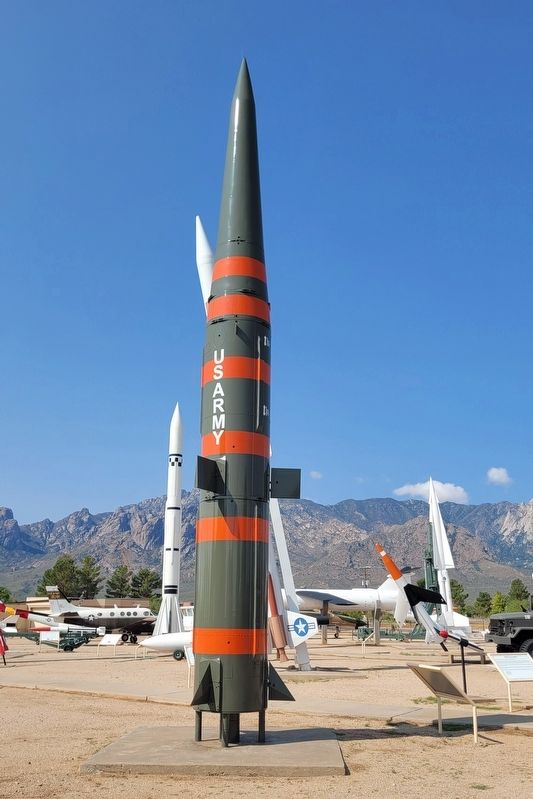
Pershing was the first and only solid-fueled MRBM (Medium Range Ballistic Missile) deployed by the U.S. Army. Named in honor of General of the Armies John J. ("Black Jack") Pershing, famed commander of the American Expeditionary Forces during World . . . — — Map (db m252759) HM
Pershing II was a two-stage improved version of Pershing Ia. It utilized a maneuverable re-entry vehicle and radar area-correlation guidance. By comparing the on-coming target with stored images, the missile's accuracy was greatly improved. After . . . — — Map (db m252590) HM
A product of the Army Ballistic Missile Agency (ABMA) at Redstone Arsenal in Huntsville, Alabama under the leadership of Wernher von Braun, Redstone was designed as a surface-to-surface missile for the U.S. Army and was named for the arsenal on 8 . . . — — Map (db m252900) HM
The Redstone program proved to be a bone of contention between the Army and Air Force due to their different ideas of nuclear warfare. The Army favored using small warheads on mobile missiles as tactical battlefield weapons while the Air Force, . . . — — Map (db m253016) HM
Pogo-Hi was a rocket-propelled target missile designed primarily for testing the guidance and control systems of missiles. It was an up-graded version of the Pogo target. The chief external difference between the two was the fins: Pogo . . . — — Map (db m252854) HM
Developed in the 1950s, the U.S. Navy's QH-50 DASH (Drone Anti-Submarine Helicopter) was the first, and so far only, operational unmanned helicopter designed for a combat role.
The DASH program had its roots in the late 1950s, when the U.S. . . . — — Map (db m252901) HM
Roland was a French/German mobile short-range air defense missile system. The U.S. Army developed and evaluated an American version of the system, but in the end did not adopt it for large-scale operational service.
Roland was a compact mobile . . . — — Map (db m252741) HM
RP-76 (Radioplane) was a subscale radio-controlled target drone, used in testing surface-to-air and air-to-air weapons at White Sands. It provided air defense personnel with experience in firing at a real target.
The target was air-launched . . . — — Map (db m252738) HM
SAGMI, an acronym for "Surface Attack Guided Missile," was one of many developmental vehicles tested by the Air Force at White Sands for the purpose of attacking ground targets. The missile was launched from aircraft at a safe distance so the crew . . . — — Map (db m252745) HM
The little Shavetail was an unguided rocket used as a research vehicle to test various aspects of rocket flight. In the 1950s, missile and rocket design was still in its early development and many fuselage shapes, fin configurations, propulsion and . . . — — Map (db m252856) HM
The Sidewinder AIM-9 is one of the oldest, least expensive and most successful missiles in the U.S. weapons inventory. It is perhaps the most widely used air-to-air missile in the West, used by 27 nations other than the United States and in every . . . — — Map (db m253030) HM
The Short Range Attack Missile (SRAM) was a small air-to-surface Air Force missile launched from B-52 and F-111 strategic bombers. On the B-52, it replaced the Hound Dog missile.
Armed with a nuclear warhead, the SRAM was propelled by a . . . — — Map (db m252747) HM
A French anti-tank missile which was used by the U.S. to train gunners for anti-tank operations. This wire-guided missile was designed to be man handled and could be fired from the ground, a vehicle or helicopter. U.S. Army.
Length: 3.5 feet . . . — — Map (db m253084) HM
The instrument seen here is one of the early tracking telescopes that supported operations at WSMR during the height of the Cold War. Designed by engineers at the Army's Ballistics Research Laboratory in Maryland using direct input from Clyde . . . — — Map (db m252601) HM
The TOW missile is the main heavy anti-tank guided missile of the US Army and US Marine Corps. Spools of wire are unraveled from its tail, giving the missile its name. TOW is an acronym for "tube-launched, optically-tracked, wire-guided missile." . . . — — Map (db m252751) HM
Early missile flight researchers and engineers focused on two main questions during the formative decades of rocket and missile development at WSMR: "Where did it go?" and "What was it doing?" In addition to electronic instrumentation such as radar, . . . — — Map (db m252597) HM
Standard Missile 2 (SM-2) Block II was an evolution of the US Navy's proven Standard Missile 1. SM-2 is a semi-active homing, all electric, super-sonic, surfacetoair guided missile. It incorporated midcourse guidance, communication links, and . . . — — Map (db m252757) HM
The VC-6A was acquired by the Army and assigned to Redstone Arsenal, Alabama, 26 July 1966. The aircraft was used extensively transporting Dr. Wernher Von Braun between White Sands Missile Range and Redstone. It was fitted with stores for mounting . . . — — Map (db m253106) HM
White Sands Proving Ground, as it was first called, is home to America’s first large-scale rocket and missile launch facilities. Established in 1945, the launching here of 67 V-2 rockets and many other vehicles propelled the United States into . . . — — Map (db m140621) HM WM
Mostly engine, this vehicle was used as a target for the Nike and Hawk air defense systems under test at White Sands. The XM-21 was guided by radio remote control and its jet turbo engine propelled it to speeds up to 500 knots. A two-stage parachute . . . — — Map (db m252913) HM
As threat vehicles developed the capability to fly higher and faster than the speed of sound it became necessary to provide supersonic targets for the testing of U.S. missiles. The air-launched target was developed by the Air Force to provide the . . . — — Map (db m252857) HM
To the east beyond Caballo Reservoir are the rugged Caballo Mountains, uplifted about 3 miles above the downdropped Río Grande trough, along the fault scarp at the edge of the mountains. Lowest slopes are ancient granites. Black ironstone beds are . . . — — Map (db m45107) HM
This section of the Camino Real is called the Jornada del Muerto or Deadman’s Journey after the tragic fate of German trader Bernardo Gruber, El Alemán. In 1670 the Inquisition accused him of witchcraft. He escaped and attempted to cross ninety . . . — — Map (db m187520) HM
Near this spot lie the unidentified remains of an American Hero, Ebin Stanley, born Decatur County, Iowa. Ebin served with the 3rd and 5th U.S. Cavalry from 1861 to 1873. Variously described as a rancher, miner, hotel operator, Indian Scout, and . . . — — Map (db m62894) HM WM
Hillsboro was founded in the 1870’s after gold and silver was discovered in the surrounding Black Range. The town developed into an important mining and ranching center, and served as the Sierra County seat from 1884 to 1939. It was the site of . . . — — Map (db m280234) HM
Near this spot lie the unidentified remains of a true American hero. Born in Ireland in 1839, James McNally served in the 3rd and 8th US Cavalry from 1858 to 1883. He was wounded during the Civil War Battle of Valverde, NM. 21 February 1862. After . . . — — Map (db m38209) HM
Built in 1879, this building has been a mercantile, pharmacy, grocery, post office and telephone exchange. Site No. 1304
A Registered Cultural Property State of New Mexico — — Map (db m38296) HM
"History may be searched in vain for an equal march of infantry" —Lt. Col. Cooke
The Mormon Battalion, of some 500 men marched through this area during November of 1846. The march covered over 2000 miles from Council Bluffs, Iowa to San Diego, . . . — — Map (db m38297) HM
Built in 1927, this historic Warren deck truss bridge spans Percha Creek, cutting through an impassable but beautiful gorge below. The bridge was constructed during a difficult project to build the Black Range Highway, now NM 152. This structure has . . . — — Map (db m280235) HM
Arriving in the silver mining boomtown of Kingston in 1886, Sadie Jane Creech Orchard is arguably the most colorful woman in New Mexico history. Sadie opened brothels, worked as a prostitute, built and operated hotels, restaurants, and co-owned and . . . — — Map (db m280236) HM
At the top of the pass are Tertiary volcanic
and Paleozoic sedimentary rocks that also
form the high cliffs of the Caballo Mountains
seen 35 miles to the east. The two ranges
were joined until the Rio Grande Rift formed
a graben that settled . . . — — Map (db m308867) HM
Why is it called Lake Valley? The town was originally located north of here, and during the 1870's derived its name from nearby relic lake beds. At that time it was just a small stage stop. That location was flooded, and the small settlement was . . . — — Map (db m97440) HM
Magnolia Ellis was a "magnetic healer." Born in Hill County, Texas, she settled in Hot Springs, today's Truth or Consequences, in 1937, and built a two-story residence and office that is listed in the National Register of Historic Places. She denied . . . — — Map (db m253637) HM
Carrie Wooster Tingley came to the territory of New Mexico in 1910 seeking treatment for tuberculosis. By 1937, she was the state's first lady and a strong advocate for sick and disadvantaged children. She established Carrie Tingley Hospital for . . . — — Map (db m253249) HM
Pueblo Indians irrigated and farmed the Rio Grande Valley for several hundred years before the Spaniards arrived and continued the tradition. Built between 1910-1916, Elephant Butte Dam when completed was the world's largest irrigation reservoir. It . . . — — Map (db m45125) HM
Situated beside the huge, 36,000-acre Elephant Butte Reservoir, this is one of the largest and most popular parks in New Mexico. It combines boating, waterskiing, fishing and other water-based sports with land activities such as camping, picnicking, . . . — — Map (db m45110) HM
Located on the east side of Elephant Butte Lake, the fort was named for Captain Alexander McRae, who died in the Civil War battle of Valverde, New Mexico, February 1862. Garrisoned over time by units of the New Mexico Volunteers, California . . . — — Map (db m159034) HM
In the late 1930s, Magnolia Ellis became regionally famous for her healing powers, drawing thousands to her Broadway clinic. The town's reputation as an affordable health resort was a big draw when many sought to cure their own ailments. The . . . — — Map (db m269271) HM
(front)
Magnolia Ellis was a healer with a special gift. She opened a clinic in Hot Springs, today's Truth or Consequences. Patients claimed to have a feeling of electricity when she touched them. Recognized by most notable doctors of the . . . — — Map (db m45109) HM
President Franklin Roosevelt's "New Deal" was a sweeping Great Depression stimulus project. The Work Progress Administration (WPA) put millions to work constructing public buildings, sidewalks, roads, employing musicians, artists, writers, . . . — — Map (db m253241) HM
In 1581, Capitán Francisco Sánchez Chamuscado took possession of this region for the King of Spain, naming it the Province of San Felipe. Significant European settlement of the area, however, did not occur until the mid-1800s. Once called Hot . . . — — Map (db m45108) HM
In 1581, Capitan Franciso Sanchez Chamuscado took possession of this region for the King of Spain naming it Ojo de Zoquete (mud spring) in the province of San Felipe. Native Americans first used these springs for healing; in early 20th century, . . . — — Map (db m242470) HM
Cutting through the southern edge of the Manzano
Mountains, this area has always been an important
trade route. The trail linked Abó and the Salinas
pueblos to the Rio Grande pueblos, fostering trade of
beans, cotton, buffalo meat and salt with . . . — — Map (db m235442) HM
Northeast part of Plains of San Agustin, occupied some thousands of years ago by large intermontane lake, is downdropped graben bordered by uplifted volcanic masses. San Mateo and Luera Mountains and Pelona Mountains are southeast and Horse . . . — — Map (db m238891) HM
The Camino Real wound its way below the black basaltic buttes of San Acacia, seen to the southeast. Named Acomilla, or Acomita (little Acoma) by the Spanish, these buttes form the walls of a narrow passage for the Rio Grande, along which hostile . . . — — Map (db m45215) HM
Present-day La Joya is located near the site of an ancient Piro Indian Pueblo that the Spanish named Nueva Sevilla, or Sevilleta. During the eighteenth century, this was the southernmost settlement along the Camino Real before the travelers ended . . . — — Map (db m67105) HM
Dunes along this part of the Rio Grande Valley are formed by sand blown northeastward from the normally dry bed of the Rio Salado (salty river). The Rio Grande is in a deep trench between the uplifted Los Pinos Mountains to the east and the . . . — — Map (db m45219) HM
The Camino Real passed near here below the bluffs on the east bank of the Rio Grande. Apache raids prevented permanent Spanish settlement of this area until the early 1800s, when the village of Sabino was established on the east bank of the river . . . — — Map (db m45178) HM
In 1582 and 1583, Antonio de Espejo and his party followed the Rio Grande north to the Bernalillo area. Espejo was trying to learn the fate of two Franciscan friars who stayed with the Pueblo Indians after the Rodriquez – Sanchez/Chamuscado . . . — — Map (db m68057) HM
Fort Craig is on alluvial gravelly sands, derived from the mountains to the west, sloping toward Rio Grande to east. Magdalena Mountains to northwest and San Mateo Mountains to west are mainly thick piles of volcanic rocks. San Andres Mountains on . . . — — Map (db m68055) HM
Kelly prospered in the 1880s after lead and silver discoveries around 1866. But it was the discarded zinc carbonate - vital in paint manufacturing - that made Kelly boom in the early 1900s. Stores, banks, saloons, schools, and churches lined its . . . — — Map (db m238361) HM
Silver was discovered in Kelly around 1866 and the town site was laid out in circa 1879. Kelly boomed with silver mining and eventually zinc mining, becoming one of central New Mexico's most prosperous mining towns. At one time it boasted a . . . — — Map (db m280237) HM
Magdalena is located in a mineral-rich area which became a center of silver mining in the 1860's. In 1885, a railroad was built to the smelter in Socorro, and Magdalena became an important railhead for cattle, sheep, and ore. — — Map (db m280238) HM
Named for Magdalena Peak, Magdalena is located in a mineral-rich area which became a center for silver and zinc mining in the 1860's. In 1884, a railroad spur was built from the smelter in Socorro, and Magdalena became an important railhead for . . . — — Map (db m280239) HM
Magdalena Mountains to the west are topped by South Baldy at 10,783 feet; Magdalena Peak at 8,152 feet. La Jencia plain to the east is bisected by Water Canyon three miles below this marker. The bench along the edge of the mountains is Magdalena . . . — — Map (db m280240) HM
The Magdalena Mountains to the west are topped by South Baldy at 10,783 feet; Magdalena Peak at 8,152 feet. La Jencia plain to the east is bisected by Water Canyon three miles below this marker. The bench along the edge of the mountains is Magdalena . . . — — Map (db m280241) HM
South across the road lies one of the west's historic "hoof highways" which was used annually from 1885 until 1971. Sheep and cattle were driven to and from the railroad at Magdalena, NM or to Springerville, AZ. The driveway was 5 to 10 miles wide . . . — — Map (db m60565) HM
The mountain range seen along the east bank of the Rio Grande is named after Father Cristobal de Salazar of the 1598 Juan de Onate expedition. The northern edge of the twenty-one mile range is said to resemble the profile of the good friar. This . . . — — Map (db m68056) HM
Twenty miles north of Magdalena, Riley was a small agricultural village originally named Santa Rita by its Hispanic founders in the mid-nineteenth century. By the late 1880's mining drove the town's economy and in 1890 it was granted a post office . . . — — Map (db m280242) HM
Work on the massive walls of this complex started after a new priest, Diego de Santander, was assigned to live here in 1659. Men of this pueblo carved and placed the wooden beams. Women and children mixed mud mortar, laid stones, and plastered . . . — — Map (db m281296) HM
The many names associated with the low ridge above - Cueloze, Las Humanas, San Buenaventura, and, most recently, Gran Quivira - hint that its 800 - year history is layered and complex. The indigenous people whose plazas and apartments you will see . . . — — Map (db m281240) HM
Pueblo Indians ground and cooked saltbush seeds as a cereal and may have used saltbush ashes as both a baking powder and a dye.
(Diagram) fruit
— — Map (db m281101) HM
Gran Quivira, called Las Humanas by early Spanish explorers, was the largest of the Salinas pueblos. From its beginnings as a nearby cluster of pithouses 1,200 years ago, it grew into a thriving village of more than 20 masonry house blocks . . . — — Map (db m281126) HM
Salinas Pueblo Missions National Monument preserves the remnants of three indigeous villages where Spanish friars started missions nearly 400 years ago. These pueblos were major trade centers for centuries prior to the arrival of Spanish explorers. . . . — — Map (db m281007) HM
For almost 30 years, no priest lived at the mission established for this pueblo. The first Franciscan assigned here, Francisco Letrado, started the church walls you see to your right in 1630.
New believers helped Friar Letrado convert . . . — — Map (db m281293) HM
Round, aromatic juniper berries were eaten raw and used to flavor meat. Pueblo mothers shredded and crused the shaggy bark for use as diaper material. — — Map (db m281129) HM
At Gran Quivira abundant sunshine and sparse rainfall provide excellent growing conditions for nutritious grasses and shrubs. Pueblo Indians once gathered plants and hunted game which foraged on these sources of stored solar energy. The National . . . — — Map (db m281036) HM
The pricklypear was an important food source here at Las Humanas. The Puebloans ate the juicy fruits, called tunas, after singing them over an open fire. They also boiled and ate the pads after removing the spines. — — Map (db m281114) HM
Yucca seeds, flowers, and buds are edible. Puebloans weaved rope, sandals, and mats from the long fibers in the leaves and crushed roots to make soap. Uniquely adapted moths pollinate each yucca species. — — Map (db m281127) HM
The first people known to live in this area built their homes partially underground, with upper walls and wooden roofs covered by thick layers of earth. For many centuries, these pithouses were the most typical dwellings to be found in the . . . — — Map (db m281241) HM
Franciscan missionaries tolerated the kachina dances of the Puebloan religion at first. For a while, a new church coexisted next to the kiva you see just down the hillside behind you. But by the 1660s, changes in church policy forced traditional . . . — — Map (db m281290) HM
During hard times the Pueblo people ate the singed yellow fruits of the cholla raw and cooked the flower buds which are rich in calcium. — — Map (db m281035) HM
Traveling with the colonizing expedition of Juan de Oñate, Doña Eufemia rallied Spanish soldiers to persevere when morale broke down during their long journey on the Camino Real. Settling in present-day New Mexico, she rallied 22 women to defend the . . . — — Map (db m280243) HM
Winds blowing across the usually dry, sandy riverbed of Rio Salado formed dunes along this part of the Rio Grande Valley. The Rio Grande, just southwest here, follows a massive geological trench shaped millions of years ago when huge blocks of land . . . — — Map (db m67211) HM
Work was begun on the "New" Hospital in 1869, but it was not finished until 1874 or later. After the Civil War, "Buffalo Soldiers” were stationed here, and "colored" and "white" wards and barracks were designated. The design of this building, . . . — — Map (db m253326) HM
A bloody Civil War battle was fought near Cortadero Mesa, directly ahead, across the Rio Grande, on February 21, 1862. Below the small village of Valverde, Confederate forces led by Colonel Henry Hopkins Sibley clashed with Colonel E.R.S. Canby's . . . — — Map (db m253616) HM
Colonel Edward Richard Sprigg Canby and Colonel Henry Hopkins Sibley were seasoned soldiers and leaders with many Indian campaigns under their belts by the time they confronted one another in the 1862 Civil War Battle of Valverde, a few miles from . . . — — Map (db m253337) HM
In the 1860s, a coal field east of San Antonio was occasionally mined by soldiers for heating fuel and to fire their blacksmith ovens. In 1883, the Santa Fe railroad built a bridge across the Rio Grande at San Antonio and laid track to the new . . . — — Map (db m45175) HM
Life at Fort Craig during its heyday, between 1854 and 1884, was isolated and rustic for soldiers and civilians alike. Loneliness, tension, and tedium were all forces to be reckoned with. So was social stratification; officers and their families . . . — — Map (db m253297) HM
The first commanding officer's quarters, in 1854, were located across the parade ground, but by 1869 the official ground plan shows that the post commander resided here. This may be the location in February, 1862, where Colonel Edward R. S. Canby . . . — — Map (db m253277) HM
From the Report On Barracks And Hospitals:
"The post was designed for two companies. The barracks, two in number, built of adobe in the form of a hollow square, each inclosing a plazita, are occupied, the one by white troops, the other by colored . . . — — Map (db m253336) HM
One of the reasons for selecting this location for Fort Craig was the good grazing on the surrounding plain. Hay was cut and stored in the stable area for the many draft and cavalry animals required by the Fort. Horse and mule herds were often . . . — — Map (db m253317) HM
These defensive earth bastions were constructed early in the Civil War (probably in the winter of 1861-62) while Confederate troops massed in El Paso and Mesilla near Las Cruces for the campaign to the north. By the time Sibley's march began, the . . . — — Map (db m253294) HM
In the autumn of 1540, Coronado's conquistadores entered the Rio Grande valley from the north, after visiting the Zuni pueblo of Hawikku, south of modern-day Gallup, and the Tiguex pueblos near Bernalillo and Albuquerque. From early records, . . . — — Map (db m253262) HM
The 1,200-mile El Camino Real was the main artery for exploration, travel, commerce, and settlement in what is now the State of New Mexico from the sixteenth century to the beginning of the twentieth century. In this region, much of El Camino Real . . . — — Map (db m253610) HM
Interpretive Reconstruction
In 2014 the Bureau of Land Management reconstructed a portion of the historic earthworks in honor of the soldiers who built and defended Fort Craig. The plans used modern materials, with dimensions based on historic . . . — — Map (db m253260) HM
The Third U.S. Infantry built Fort Craig in 1852, after the Mexican-American War, to replace ill-sited, poorly constructed, and short-lived Fort Conrad, a few miles north of here. The new fort's location on this low bluff overlooking the Rio . . . — — Map (db m253302) HM
The Sally Port was the main entrance of the Fort and was a gate wide enough for wagons and mounted troops to pass through in column formation. For a time, this guard house served as the Territorial Prison. No photographs or drawings of this . . . — — Map (db m253271) HM
The Treaty of Guadalupe Hidalgo ended the war between the United States and Mexico in 1848. Mexico surrendered more than half of its land to the US. Trade along El Camino Real, then known as the Chihuahua Trail, continued, but now linked the two . . . — — Map (db m250813) HM
This row of buildings housed the original hospital, at the extreme left, and at various times the Quartermaster and Commissary offices, the materials issue rooms, individual officers' quarters, and laundresses' quarters. An 1867 photo shows these . . . — — Map (db m253322) HM
The mountains on the horizon (pictured below) are the start of the Jornada del Muerto (Journey of the Dead Man). This feared section of El Camino Real de Tierra Adentro forced travelers to cross 90 miles of open desert. Travelers had followed the . . . — — Map (db m250816) HM
These buildings housed officers with their families and servants, including the original Post Commander, before special quarters were built across the parade ground. The 1873 Surgeon General's report describes them as "well finished, being plastered . . . — — Map (db m253333) HM
This photograph was taken by an unknown photographer a few years after the Civil War from approximately this location. The two adobe enlisted men's quarters are seen to the right and left. Fort Craig was built as a two-company post, with matching . . . — — Map (db m253275) HM
Standing at Fort Craig today, looking out over a peaceful and unpopulated landscape, you may be surprised to learn that this area has been the scene of bustling human activity off and on for thousands of years.
First came nomadic Paleoindian . . . — — Map (db m253258) HM
Established in the mid 1600s, the mission of San Antonio de Senecú was the last outpost on the Camino Real before the Mesilla Valley to the south. Around 1820 Hispano settlers from the north re-occupied the area after the Pueblo Revolt. Conrad . . . — — Map (db m45172) HM
Established in the 1840s on the east bank of the Rio Grande, San Pedro became an important trading center along the Camino Real. The sister village of San Antonio, it was once known for its extensive vineyards and other agricultural produce. The . . . — — Map (db m45174) HM
Fort Craig was never designated an official supply depot but it often served as a central location for disbursement of supplies to other posts. The supplies at the post, as well as its strategic location, were of utmost importance to the Confederate . . . — — Map (db m253282) HM
This photograph was taken in 1867, looking east toward the lava bluffs across the river. The powder magazine in the left center was completed in 1863, with a floor three feet below ground surface, heavy vertical post walls, and a thick cap of earth, . . . — — Map (db m253319) HM
Anthropologists tell us that ancestral Apache people had entered the Southwest in the early 1500s. When the United States acquired much of the Southwest through the Treaty of Guadalupe Hidalgo in 1848, it also inherited the difficult and risky . . . — — Map (db m253285) HM
You may be surprised to learn that a bloody confrontation of the Civil War was fought only a few miles from Fort Craig.
The main Battle of Valverde was fought in the winter on February 21, 1862. Colonel Edward Richard Sprigg Canby's Union . . . — — Map (db m253339) HM