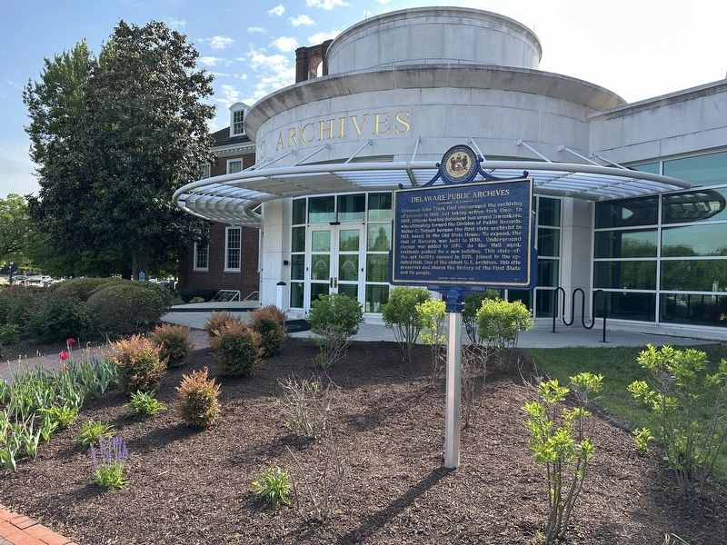
Governor John Clark first encouraged the archiving of records in 1818, but taking action took time. In 1905, citizens fearing document loss urged lawmakers, who ultimately formed the Division of Public Records. Walter G. Tatnall became the first . . . — — Map (db m271731) HM
Established May 15, 1891, by an act of the Delaware General Assembly as the State College for Colored Students, by virtue of the 1890 Morrill Land-Grant Act under the provisions of the 1862 Morrill Act of Congress. Incorporated July 1, 1891. . . . — — Map (db m39054) HM
On College Road 0.7 miles west of North Dupont Highway (U.S. 13), on the right when traveling west.
On June 17, 1921, the Board of Trustees of the State College for Colored Students, later known as Delaware State College, approved a resolution recommending the establishment of a high school for Negro students on its campus. This was the second . . . — — Map (db m142491) HM
Near Frontage Road south of Loop Road, on the right when traveling south.
Susan Yost Ph.D. and Lou Calabrese
Claude E. Phillips Herbarium, Dept. of Agriculture & Natural Resources, and Cooperative Extension, College of Agriculture & Related Sciences
The DSU Arboretum became an accredited arboretum on the Morton . . . — — Map (db m273475) HM
Near Legislative Avenue at Martin Luther King Jr. Boulevard North, on the right when traveling north.
Honoring women throughout our history who have served in defense of our state and our nation.
In Tribute to the women of the first state who have come forward to protect and defend our state and our nation in the military and supporting . . . — — Map (db m194642) WM
Near Martin Luther King, Jr. Boulevard east of Legislative Avenue, on the left when traveling east.
Delaware Governor Walter W. Bacon speaks at ceremonies after a parade in Wilmington in 1945 honoring Medal of Honor recipient, Army Sergeant James P. Connor. Connor landed in North Africa in November, 1942, with the 9th Division and went on to . . . — — Map (db m194618) HM WM
On Martin Luther King Jr. Boulevard North just east of East Water Street, in the median.
Of the eighteen Delawareans who have been awarded the Medal of Honor since it was established by an Act of Congress in 1862, fifteen received the medal for actions during the 19th century — twelve from the Civil War, one from the Indian Wars in . . . — — Map (db m198966) HM WM
Near The Green east of South State Street, on the right when traveling north.
In March 1920, Governor John G. Townsend called a special session of the Delaware General Assembly to vote on the ratification of the 19th amendment. Suffrage and anti-suffrage groups descended on Dover that spring to try to sway the vote in their . . . — — Map (db m190714) HM
On West North Street just north of South Governors Avenue (Alternate U.S. 13), on the left when traveling west.
The Old State House
Fact: After the capital was moved from New Castle to Dover in 1777, the State House was built as the first permanent capitol building in 1787 and finished in 1791.
Information: This Georgian . . . — — Map (db m227860) HM
On The Green east of South State Street, on the right when traveling east.
Delaware's first "urban park without boundaries" is a partnership of the historical and cultural sites of Dover.
John Bell House:
Take a walking tour of The Green and step back in time as Historical Interpreters work on 18th . . . — — Map (db m307059) HM
On Alternate U.S. 13, on the right when traveling south.
County seat since 1680. William Penn in 1683 ordered Town site laid out and named Dover. Plotted in 1717. Temporary capitol in 1777 and permanent capitol since 1779. Federal Constitution ratified here in 1787, making Delaware first State in Union. . . . — — Map (db m39061) HM
On Loockerman Street close to Legislative Avenue, in the median.
County seat since 1680. William Penn in 1683 ordered Town site laid out and named Dover. Plotted in 1717. Temporary capitol in 1777 and permanent capitol since 1779. Federal Constitution ratified here in 1787, making Delaware first State in Union. . . . — — Map (db m39107) HM
County seat since 1680. William Penn, in 1683, ordered townsite laid out and named Dover. Plotted in 1717. Temporary capital in 1777 and permanent capital since 1779. Federal Constitution ratified here in 1787 making Delaware First State in Union. . . . — — Map (db m51115) HM
On North Dupont Highway (U.S. 13) at Entrance to Dover Downs on North Dupont Highway.
Dover Downs began as a dual-purpose racing facility that featured a five-eights' mile dirt horse racing track built within the larger one mile race track of Dover International Speedway. Gov. David P. Buckson, Lt. Gov. John W. Rollins, and Melvin L. . . . — — Map (db m141445) HM
Dover International Speedway-The Speedway hosted its first NASCAR event, the Mason-Dixon 300, on July 6, 1969. Richard Petty won that raced by 6 laps. The highly-banked, one-mile oval track was created, financed, and built by Gov. David P. Buckson, . . . — — Map (db m141439) HM
The Light Infantry Company of Dover, a part of the 1st Battalion of Kent County, mustered in on 2 April 1776. Each militia volunteer was uniformly armed, equipped, and wore a standard military coat of green faced with red lapels, cuffs, and . . . — — Map (db m39576) HM
Near Frontage Road south of Loop Road, on the right when traveling south.
Delaware State College Highlights:
Accreditation — Dr. Holland restructured academic programs to create a stronger academic environment. In 1957, Delaware State College regained accreditation from the Middle States Commission on . . . — — Map (db m273447) HM
Near Frontage Road south of Loop Road, on the left when traveling north.
For those
who served
1941 - 1945 WWII
Delaware State University
Tuskegee
Airmen
Lt. Luna I. Mishoe, Photographic Intelligence Officer •
Lt. Maxwell Honemont, Tuskegee Trained Observation Pilot •
Airman Nathan O. Thomas, 99th . . . — — Map (db m273486) HM WM
On College Avenue 0.7 miles west of North Dupont Highway (U.S. 13), on the right when traveling west.
From 1921 until 1952 this simple brick structure, named for its benefactor, Pierre S. Dupont, served as a laboratory-classroom for students enrolled in the teaching course at the State College for Colored Students (now DSU).
The educational . . . — — Map (db m142492) HM
On West North Street at Dairy Barn Way on West North Street.
In 1680, a large tract of land called "Brothers Portion" was warranted to John and Richard Walker. In 1695, 200 acres of the parcel were purchased to create the town of Dover. When the town plot was completed in 1718, John Mifflin purchased 69 acres . . . — — Map (db m94380) HM
Near Korean War Veterans Memorial Highway. Reported damaged.
The St. Jones River abounds with finfish that depend on an estuarine environment. A scientific "profile" of the lower St. Jones River estuary was conducted by the Delaware National Estuarine Research Reserve in 1994-1995, identifying 26 different . . . — — Map (db m299328) HM
Near Kenton Road (County Road 104) north of Baltray Road, on the right when traveling north.
Pre-History
The Fork Branch Nature Preserve with its freshwater marshes and well-drained uplands was an important area to native peoples. They came here seasonally for many thousands of years for the wide range of natural food resources.
A . . . — — Map (db m273497) HM
Near Kenton Road (County Road 104) north of Baltray Road, on the right when traveling north.
History
In its more recent history, the preserve had become a crossroads for milling and transportation. The first Europeans settled in this area in the late 17th century. At that time, John Albertson and John Mumford acquired the 877-acre . . . — — Map (db m273498) HM
In 1947 the International Latex Corporation established a specialty products division and chose this site for its location. The company’s rise to prominence as a supplier of aeronautic and aerospace equipment began in 1952 when it was contracted to . . . — — Map (db m39062) HM
On Levy Court Lane at South Little Creek Road (County Road 67), on the right when traveling south on Levy Court Lane.
In honor of all Gold Star Mothers and Families from all conflicts
"I pray that our Heavenly Father may assuage the anguish of your bereavement, and leave you only the cherished memory of the loved and lost, and the solemn pride . . . — — Map (db m198917) WM
On Kings Highway Southwest at Pennsylvania Avenue, on the right when traveling north on Kings Highway Southwest. Reported permanently removed.
The land on which Hall House stands was originally part of the Woodburn property. In 1885, Thomas Wilson, Jr. purchased an acre from his uncle living in Woodburn and built this house, which was completed in 1887. In 1983, during the . . . — — Map (db m43736) HM
On Kings Highway Southwest north of Pennsylvania Avenue, on the right when traveling north.
The land on which Hall House stands was originally part of the Woodburn property. In 1885, Thomas Wilson, Jr. purchased an acre from his uncle living in Woodburn and built this house, which was completed in 1887. In 1983, during the . . . — — Map (db m198999) HM
"The Penman of the Revolution." Member of Delaware colonial and state assemblies. Member of Continental Congress, Annapolis Convention, and Philadelphia Federal Constitutional Convention. Signer for Delaware of Articles of Confederation and Federal . . . — — Map (db m39583) HM
On this site, Delaware became the first state to ratify the Constitution of the United States. December 7, 1787. We, the deputies of the people of the Delaware state, in Convention met, having taken in our serious consideration the Federal . . . — — Map (db m39074) HM
On Levy Court Lane at South Little Creek Road (County Road 67), on the right when traveling south on Levy Court Lane.
For nearly 65 years Dover VFW Memorial Post 9952 reached out to fellow veterans, their families, and the community at large. Its faithful members served during times of war and peace and willingly placed themselves in harm's way to proudly serve . . . — — Map (db m198915) HM
On The Green east of South State Street, on the right when traveling east. Reported permanently removed.
The 18th-century front section of this structure is the oldest surviving wood building in Dover. It is being restored to serve as an interpretive center for the First State heritage Park. The 20th-century rear additions will be removed to return . . . — — Map (db m39097) HM
Near South Governors Avenue 0.1 miles south of W North Street, on the right when traveling south.
Born in Dagsboro, Delaware, 1796. Graduate of Yale College 1815. Member of Delaware House of Representatives 1824. Secretary of State of Delaware 1826-1828. United States Senator 1829-1836, 1845-1849 and 1853 until his death, 1856. Chief Justice of . . . — — Map (db m4748) HM
Near The Green near South State Street, on the right when traveling east.
Court was first held in Jones County in 1680. In 1682 William Penn changed the county’s name to Kent County. On August 11, 1683 William Penn directed that the town of Dover be laid out and that a courthouse be erected at the intersection of its two . . . — — Map (db m284018) HM
On Roosevelt Avenue, on the right when traveling east.
The Kent County Theatre Guild (KCTG) formed in 1953 to provide community theater in central Delaware. The volunteer organization incorporated in 1961 and initially performed theatrical productions at local high schools and Dover's Hinkle Building. . . . — — Map (db m243653) HM
Near North State Street close to Governors Boulevard (Alternate U.S. 13), on the left when traveling south.
Dedicated to the lasting memory of those who lie within this cemetery that served their country to protect our nation's beliefs and principles to achieve peace among other nations and ours. — — Map (db m142493) WM
On William Penn Street at Legislative Avenue on William Penn Street.
Legislative Hall was dedicated as the state's new capitol building in 1933, replacing The Old State House on The Green. The Senate and the House of Representatives of Delaware's General Assembly meets here. The building also houses the offices of . . . — — Map (db m194643) HM
On M.L.K. Jr Boulevard North at Legislative Avenue, on the left when traveling west on M.L.K. Jr Boulevard North.
Legislative Hall was dedicated as the state's new capitol building in 1933, replacing The Old State House on The Green. The Senate and the House of Representatives of Delaware's General Assembly meets here. The building also houses the offices of . . . — — Map (db m194645) HM
Dedicated to you, a free citizen in a free land, this reproduction of the Liberty Bell was presented to the people of Delaware by direction of The Honorable John W. Snyder, Secretary of the Treasury.
As the inspirational symbol of the United . . . — — Map (db m42759) HM
On University Drive north of Loop Road, on the right when traveling north.
The land where DSU stands was once a large slave-holding plantation owned by Nicholas Loockerman. In 1723 Loockerman purchased 600 acres of land on the St. Jones River upon which his descendants built a saw-mill and stately Georgian-style brick . . . — — Map (db m273489) HM
In 1723 Nicholas Loockerman purchased 600 acres of land known as “The Range.” Following his death in 1771, the property passed to his grandson Vincent Loockerman Jr. Evidence suggests that he built the Georgian-style mansion known today as . . . — — Map (db m39053) HM
Mount Zion African Methodist Episcopal Church-The genesis of the African Methodist Episcopal Church can be traced to Delaware in 1777, when a young slave named Richard Allen experienced a spiritual awakening at a meeting conducted by an itinerant . . . — — Map (db m141313) HM
On South State Street at East Water Street on South State Street.
In this churchyard lie the remains of Nicholas Ridgely, Statesman and Jurist. Born in Dover, 1762, eldest son of Dr. Charles Greenbury Ridgely and Mary Wynkoop Ridgely. Member of State Convention which ratified the Federal Constitution, December 7, . . . — — Map (db m39066) HM
On South State Street at Water Street, on the right when traveling north on South State Street.
Founded as mission by the Society for the Propagation of the Gospel in response to a petition from twenty-two inhabitants of Dover in 1703. The present church was erected in 1734. Among early missionaries here was the Rev. Charles Inglis, later . . . — — Map (db m3803) HM
Near South Governor's Avenue 0.1 miles south of W North Street, on the right when traveling south.
Built 1790 during the pastorate of the Rev. John Miller to replace the earlier log church erected about 1715 on this plot designated as “Meeting House Square”. Presented by the Presbytery to the State of Delaware for a state museum in 1947. Restored . . . — — Map (db m5048) HM
On S. State Street at Kings Highway SW on S. State Street.
Joseph S. Barbizzi, James C. Beuter, Cleyo E. Blanchard, Benjamin P. Bowings, George B. Buckalew, Sr., John J. Casey, Malcom T. Chandler, Casimir J. Chiczewski, Herbert D. Clifton, E. Hart Davis, James D. Davis, Joel W. Davis, Charles J. Donnelly, . . . — — Map (db m50621) WM
On Levy Court Lane at South Little Creek Road (County Road 67), on the right when traveling south on Levy Court Lane.
Since World War 1, more than 82,000 American soldiers are unaccounted for.
This unoccupied seat is dedicated to the memory of those brave men and women and to the sacrifices each made in serving this country.
God bless you. God bless . . . — — Map (db m198947) WM
Born in 1740 in Dover, Kent Co., DE
Died Feb, 15, 1791 in Dover, Kent Co., DE
Justice of the Peace
Member of Joint Committee of Accounts, Committee of Correspondence, Council of Safety, and General Assembly. — — Map (db m42754) HM
On South State Street at East North Street, on the left when traveling south on South State Street.
This marker commemorates the men and women who achieved American independence. These Patriots, believing in the noble cause of liberty, fought valiantly to found a new nation.
1775 - 1783 — — Map (db m273445) WM
The Richardson and Robbins complex began in 1881, twenty-six years after Alden B. Richardson and James W. Robbins started a small cannery at another location in Dover. On this new site Richardson and Robbins prospered as canners of high quality . . . — — Map (db m42760) HM
Dr. Charles Greenbury Ridgely: Member Colonial and State Legislative Assemblies; Delegate First State Constitutional Convention 1776.
Nicholas Ridgely (the younger): Member of Convention that ratified Federal Constitution 1787; Delegate . . . — — Map (db m238346) HM
Near Frontage Road south of Loop Road, on the right when traveling south.
Dr. Luna I. Mishoe served as the President of Delaware State University from 1960 until 1987 and as a math and physics professor from 1946 to 1948. DSU flourished under Dr. Mishoe's administration. Fourteen new buildings were constructed, 18 . . . — — Map (db m273476) HM
On South Bay Road south of Stover Boulevard, on the right when traveling north.
May freedom's light
forever shine bright
In memory of
the victims and their families
of September 11, 2001
To the American Legion
Walter L. Fox Post 2 — — Map (db m273442) WM
On Sharon Hill Road (County Road 161/162) 0.3 miles east of Cahoon Branch Road (County Road 198), on the right when traveling east.
In 1849, Caper and Leah Carlisle deeded a quarter-acre of land to Meeting House Trustees Jacob Allston, Peter Carlisle, James Collins, Perry Hawkins, and Nathaniel White. The Carlisles and the trustees were part of a free African American community . . . — — Map (db m199002) HM
On W. North Street at South Queen Street on W. North Street.
In 1778, a Methodist Society was organized in Dover by Reverend Freeborn Garrettson. Desiring a permanent place of worship, members acquired a one-half acre lot at this location from Vincent Loockerman in 1782. Future Delaware Governor Richard . . . — — Map (db m39065) HM
On South Governor's Avenue 0.2 miles south of West North Street, on the right when traveling south.
A Presbyterian Society, present in Kent from c1694, was organized and worshipped in a log church on this site from c1708 until 1791. The Presbytery of Philadelphia recognized its congregation in 1714. The present church was built in 1791 and served . . . — — Map (db m5166) HM
From 1724 known as King George’s Tavern. On its sign was painted King George’s portrait, supplanted during the revolution, by the portrait of George Washington. For many years the old hostelry was the meeting place for political rallies and used . . . — — Map (db m3764) HM
On Kitts Hummock Road 0.1 miles west of Bergold Lane (County Road 352), on the left when traveling west.
This part of what is now Kent County, Delaware was one of the state's earliest sites of English colonization. Beginning in the 1660's plantations were established along the St. Jones River. The Dickinson family of Talbot County, Maryland was . . . — — Map (db m245466) HM
Near Korean War Veterans Memorial Highway. Reported damaged.
In Delaware, wetland resources are protected under the Federal Clean Water Act (1972). The act established the regulations for "discharges of pollutants" into wetlands and waters including the placement of soil as construction fill. A permit is . . . — — Map (db m299329) HM
On East Lebanon Road, on the right when traveling south.
The St. Jones River was straightened for commercial traffic; its floodplains and riparian wetlands filled for development; its forests cleared for homes, roads, shopping, and parking lots; it's small tributaries have been contained in pipes, and . . . — — Map (db m298206) HM
Completed in 1792 and restored in 1976, it was shared by Kent County and the State from 1792 to 1873. Prior to the construction of this building, an older county court house stood on the same site. That small brick structure, about twenty five feet . . . — — Map (db m39073) HM
On Martin Luther King, Jr. Boulevard at Legislative Avenue, on the right when traveling east on Martin Luther King, Jr. Boulevard.
In loving memory of the men and women of the first state who served our nation in World War I. Their sacrifices will never be forgotten. — — Map (db m194641) WM
Near Kenton Road (County Road 104) north of Baltray Road, on the right when traveling north.
Preservation Amidst Development
The Anne McClements Woods Tract of the Fork Branch Nature Preserve is the largest forest stand within Dover city limits, containing 259.32 acres. The preserve is home to more than 200 acres of mature forest with . . . — — Map (db m273496) HM
On Pickering Beach Road (County Road 349) at North Sandpiper Drive, on the right when traveling west on Pickering Beach Road.
Welcome to Pickering Beach Horseshoe Crab Sanctuary
Pickering Beach takes pride in its beautiful location on the Delaware Bay, which is the world's largest spawning ground for horseshoe crabs. Horseshoes crabs are part of the . . . — — Map (db m232938) HM
The Delaware Regiment fought in nearly every campaign of the American Revolution.
For a small state, Delaware's soldiers played a large role in the Revolution. Answering Congress' call, Delaware raised a regiment of 500-600 men by the summer of . . . — — Map (db m39712) HM
On South State Street at North Street, on the right when traveling south on South State Street.
In 1904, the Dover Opera House opened at this location. The theater was built with funds from a public subscription, and included a stage that was used for a variety of purposes including vaudeville, photoplays, magic lantern shows, and in later . . . — — Map (db m39104) HM
On Legislative Avenue 0.1 miles south of Duke Of York Street, on the right when traveling south.
First to ratify the Constitution of the United States
Delaware
The Compass Rose
Dedicated 7 December, 1988
Authorized by the Delaware Heritage Commission and 134th General Assembly — — Map (db m3571) HM
In Respectful Memory
of Those Delawareans who have recieved
The Congressional
Medal Of Honor
for conspicuous gallantry and intrepidity
at the risk of life and beyond
the call of duty.
—––
The Medal of Honor is the . . . — — Map (db m61103) HM WM
To commemorate and also preserve to posterity the undying fame of the patriotism and valor of the officers and soldiers of the Delaware Line who, in May 1780 were reviewed on this green for the last time immediately prior to marching on their . . . — — Map (db m3684) HM
On December 9, 1775, the Continental Congress resolved that a body of troops be raised in Delaware "for the defense of American liberty." Commanded by Colonel John Haslet, the Delaware Regiment consisted of more than 500 battle-ready troops when . . . — — Map (db m67456) HM WM
The Georgian Architecture of Poplar Hall, John Dickinson's Delaware home, suited his orderly mind and refined tastes. Built by his parents, Samuel Dickinson and Mary Cadwalader in 1740, enlarged in the 1750s, the house dominated a 5,000 acre . . . — — Map (db m284904) HM
On William Penn Street at Legislative Avenue, on the left when traveling east on William Penn Street. Reported permanently removed.
The First State Heritage Park of Dover is Delaware’s first urban “park without boundaries.” It includes the many historical and cultural attractions within Dover’s historical districts. Linking the diverse sites throughout Delaware’s capital . . . — — Map (db m3557) HM
On Duke of York Street at Legislative Avenue, on the left when traveling west on Duke of York Street.
The First State Heritage Park of Dover is Delaware’s first urban “park without boundaries.” It includes the many historical and cultural attractions within Dover’s historical districts. Linking the diverse sites throughout Delaware’s capital city, . . . — — Map (db m3560) HM
On State Street at The Green, on the left when traveling south on State Street.
This was the site of the Golden Fleece Tavern, scene of some of the most important and dramatic events in Delaware history. Built in the 1730s, the Golden Fleece was a center for community and government activities. It was a place of great . . . — — Map (db m39075) HM
On The Green east of South State Street, on the right when traveling west.
William Penn established the town of Dover in 1683. As surveyed in 1717, the town featured three public squares including The Green. Surrounded by government buildings, shops, homes, and taverns, The Green became the heart of Dover. During the . . . — — Map (db m131997) HM
On The Green east of South State Street, on the right when traveling east.
An extremely rare example of a one-and-a-half-story 18th century timber-frame building, the John Bell House has stood on the historic Dover Green witnessing many key events of Dover, the State of Delaware, and the United States. . . . — — Map (db m307062) HM
The St. Jones River, a major Delaware navigable waterway, is situated south of the John Dickinson Plantation. The river connects the Delaware Bay to the inland city of Dover. Between 1760 and 1808, John Dickinson owned six farms that bordered the . . . — — Map (db m79168) HM
On Martin Luther King Junior Boulevard North, on the right when traveling west.
Governor C. Douglass Buck appointed a committee in 1929 to review Delaware's notable historic sites and develop a way to identify them. In 1931, the General Assembly of Delaware passed and Governor Buck signed House Bill No. 62, an act . . . — — Map (db m271732) HM
On Martin Luther King Jr. Boulevard North at Legislative Avenue, in the median on Martin Luther King Jr. Boulevard North.
The images reproduced here were selected as being representative of all Delaware women who have served our state and our nation in defense plants in wartime, helping to manufacture products that support our Armed Forces. Each woman pictured on . . . — — Map (db m198970) HM
On S. State Street, on the right when traveling south.
The brick house was built in 1846. The structures to the rear consist of three separate buildings dating from 1804. They are the original tenement and two outbuildings. The first was a summer kitchen and the latter, Sara Stevenson's (1850) two room . . . — — Map (db m39099) HM
On E. Water Street at Legislative Avenue, on the right when traveling east on E. Water Street.
The Timothy Hanson House stood on this site until it was relocated in 2006. The front of the building, commissioned by the Delaware Association of REALTORS, for its headquarters in 2006, is a replica of the structure known as the Hanson house. The . . . — — Map (db m39096) HM
Each of these unique sites made a distinctive contribution to our history. Learn about the cultures transplanted by early Swedish, Dutch, Finnish, and British immigrants, and the principles of the Society of Friends (Quakers) that shaped the . . . — — Map (db m284903) HM
Union Lodge No.7, A.F. & A. M.-The origin of organized Free masonry in Dover can be traced to the formation of Old Lodge No. 18 on August 25, 1775. During its twelve years of existence, meeting were held on the "The Green" at an inn which stood on . . . — — Map (db m141285) HM
On M.L.K. Jr Boulevard North at Legislative Avenue, on the right when traveling west on M.L.K. Jr Boulevard North.
The first of the dreadnoughts of the United States Navy, the USS Delaware was laid down on November 11, 1907 at Newport News Shipbuilding & Drydock Company, and was the first battleship to have forced lubrication system for engines.
. . . — — Map (db m190725) HM
Robert P. Archer Jr. •
Donald Ray Bailey •
Paul L. Berry •
Bruch E. Clough •
Toby Ernest Collins •
George H. Coppage, III •
George W. Cripps •
Clifton Cubbage •
Bruce E. Dolbow •
Robert H. Donaway •
Harold W. Haddick •
Jan . . . — — Map (db m51117) WM
Near University Drive north of Loop Road, on the right when traveling north.
"I say!" murmured Horton. I've never heard tell
Of a small speck of dust that is able to yell
So you know what I think?…Why, I think there must
Be someone on top of that small speck of dust!
Some sort of creature of very . . . — — Map (db m273488) HM
You are standing in the "asteroid belt," a region between the orbits of Mars and Jupiter where countless rocks called asteroids orbit the sun. Every so often icy bodies called comets pass through this region on their way to the inner solar . . . — — Map (db m273490) HM
On Levy Court Lane at South Little Creek Road (County Road 67), on the right when traveling south on Levy Court Lane.
They protected and watched over us at home and on the field of battle. We are forever grateful for their undying loyalty, devotion, and faithful service. They are not forgotten. — — Map (db m198949) WM
On Martin Luther King Jr. Boulevard North at Legislative Avenue, in the median on Martin Luther King Jr. Boulevard North.
We hold in respectful memory those Delaware women, known and unknown, who have given their lives in service to our nation.
Among the thousands of Delaware women who have served our nation throughout our history. The names of most have been . . . — — Map (db m198982) HM WM
Near Kenton Road (County Road 104) north of Baltray Road, on the right when traveling north.
Chapter 73 of the Delaware Code, Title 7 states: "…it is necessary and desirable that areas of unusual natural significance be set aside and preserved for the benefit of present and future generations before they have been . . . — — Map (db m273494) HM
On North State Street at Fulton Street, on the right when traveling south on North State Street.
Wesley College is a private, liberal arts college affiliated with the United Methodist Church. It was founded in 1873 as Wilmington Conference Academy, a preparatory school for boys under the patronage of the Methodist Episcopal Church. Female . . . — — Map (db m243725) HM
On South State Street, on the left when traveling south.
The origin of this congregation can be traced to the establishment of a Methodist society in Dover in 1778. Land on North Street was obtained in 1782, and a brick chapel was completed there in 1784. Bishops Francis Asbury and Richard Whatcoat, . . . — — Map (db m39100) HM
On Forest Avenue (Delaware Route 8), on the right when traveling west.
Originally part of St. Jones Hundred, renamed Dover Hundred 1823, the boundaries being Little Creek on the north and St. Jones Creek on the south, extending from Delaware River to Maryland Line. Dover Hundred was divided 1877 into two hundreds, . . . — — Map (db m243656) HM
Near Frontage Road south of Loop Road, on the left when traveling north.
The William C. Jason Library is named in honor of Delaware State University's longest serving president. President Jason's tenure, from 1895 to 1923, was punctuated by expansive growth of both the student body and campus infrastructure. His . . . — — Map (db m273477) HM
1934 entries matched your criteria. Entries 101 through 200 are listed above. ⊲ Previous 100 — Next 100 ⊳