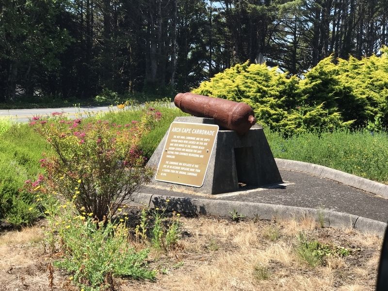
The 1821 naval carronade and the ship's capstan which were located on this site have been moved to the Cannon Beach History Center and Museum for safe keeping from continued weathering and vandalism.
The carronade was replaced at this site by an . . . — — Map (db m177297) HM
Lt. Neil M. Howison, U.S.N., arrived in the Columbia River 1 July, 1846 on board the 300-ton United States Naval Survey Schooner "Shark" for the purpose of making an investigation of part of the Oregon Country. His report was instrumental in . . . — — Map (db m113513) HM
Cannon Beach was named after a carronade (a short, smoothbore, cast iron naval cannon) found buried in the sand nearby. The cannon broke free of the USS Shark's deck during a shipwreck at the mouth of the Columbia River on September 10, 1846. . . . — — Map (db m177304) HM
The Corps of Discovery traveled thousands of miles and endured many hardships to reach the Pacific Ocean in mid-November 1895. The last sixteen miles down the Columbia River took ten days because of bad weather. The explorers huddled among the . . . — — Map (db m113006) HM
In 1921, responding to increasing popularity of travel by automobile, Captain Fritz Elfving formed the Astoria-North Beach Ferry Company to transport passengers and cars across the Columbia River.
His ferry slip on the Oregon side of the river . . . — — Map (db m113269) HM
The Columbia River is a highway for huge amounts of freight. The most frequent outbound cargoes include wheat and other agricultural products from the inland Northwest, logs and lumber, and mining products like coke or potash. Entering the river, . . . — — Map (db m113238) HM
Before the fire of 1922, much of downtown Astoria was built on pilings over the river. People built out from the original hilly shoreline, creating a level commercial district with access to the water.
Every type of business might be . . . — — Map (db m113237) HM
The oldest American settlement west of the Rocky Mountains, dating back to Lewis & Clark.
Explore our history, natural beauty and opportunities for adventure.
For free maps and visitor information, visit one of the Astoria-Warrenton . . . — — Map (db m113011) HM
The oldest American settlement west of the Rocky Mountains, dating back to Lewis & Clark. Explore our history, natural beauty and opportunities for adventure. For free maps and visitor information, visit one of the Astoria-Warrenton Chamber Welcome . . . — — Map (db m177306) HM
On April 12, 1961, Lord Astor of Hever, England, direct descendant fo John Jacob Astor from whom this city of Astoria derived its name 150 years ago, dedicated this monument to transportation. From here members of the Astor Expedition blazed . . . — — Map (db m149475) HM
People have always turned to the river for enjoyment and just plain fun. Today you may see recreational sailboats, motorboats, jet-skis, kayaks, cruise ships, windsurfers, or kiteboards sharing the river with huge commercial ships.
In the . . . — — Map (db m113250) HM
Built by Capt. Hiram Brown who came to Astoria area in 1848.
Original Portion of house built in Adairville (East Astoria), was barged downriver about 1865 to Tenth St. and rolled to present location without cracking wallpaper or breaking a . . . — — Map (db m114258) HM
This grove of nine trees is a part of the original landscaping planted around the historic 1886 Queen Anne style house of Captain George Flavel. The grove consists of a giant sequoia, ginko, Camperdown elm, bay laurel, pear, and four cork elms. . . . — — Map (db m168306) HM
This Mansion
was erected in 1883 by
Captain George Flavel,
Pioneer Columbia River Bar Pilot
and business leader
The family home for fifty years,
this property was presented to Clatsop County
by his great granddaughter,
. . . — — Map (db m113016) HM
Began his acting career
in the summer of 1922 at the
Astoria Theater
Located on this site, the building was
destroyed by fire in December, 1922
— — Map (db m113059) HM
The Columbia River Bar is considered by professional mariners to be the most dangerous bar crossing on the planet.
The Pilot Boat Peacock was built in 1964 based on a German North Sea rescue boat design.
Put into service on the . . . — — Map (db m112994) HM
Towboats began working on the Columbia in the mid 19th century.
Powerful steam tugs towed sailing vessels over the Columbia River bar.
Sternwheel steamboats, many of which operated as tugs, plied the entire Columbia River system.
During . . . — — Map (db m113234) HM
[panel 1] Great Chief of the Chinook Nation, known to Lewis and Clark, honored and respected by the founding Astorians, the Northwesters and the Hundson's Bay fur traders. [panel 2] Symbolic memorial dedicated by Comcomly's . . . — — Map (db m113009) HM
This area was once the crossroads of several cultures in Astoria.
Along the waterfront to the east and west were over 20 canneries with their hordes of workers, many of them Chinese.
After 12 to 16 hours of hard work, the Chinese went home to . . . — — Map (db m112997) HM
This authentic reconstruction of the 1852 U.S. Custom House was built to commemorate the bicentennial of the U.S. Custom Service. Work began in October, 1992 and was completed in May, 1994.
Reconstruction methods and tools duplicated those of . . . — — Map (db m113821) HM
This building was constructed in 1896 by the North Pacific Brewery and rebuilt 1928-29 by the city of Astoria to serve as a fire station.
City Commission
J C Brook, Mayor
John R Arnold -'28
Anton Sorensen -'29
E C Gearhart
Victor . . . — — Map (db m113823) HM
In 1849, the U.S. Government established the first U.S. Customs Office on the Pacific Coast in Astoria. Located just 200 feet west of this site, the founding of the original Custom House brought change to the Northwest. It signaled a growing U.S. . . . — — Map (db m113819) HM
Desiring to dominate the areas explored by Lewis and Clark, John Jacob Astor sent expeditions overland and by sea to seize the mouth of the Columbia. The schooner Tonquin arrived first and work was begun on this site April 12, 1811. "The foliage was . . . — — Map (db m113558) HM
Fort Clatsop built by Lewis and Clark in December 1805 for use as winter quarters was situated eight-tenths of a mile south of this point. The site was chosen because of the game in the surrounding country and because it was convenient to the coast . . . — — Map (db m113578) HM
The Ghadar Party, often considered the beginning of the 20th century Indian independence movement, crystalized in May 1913 at a meeting in Astoria's Finnish Socialist Hall (located behind this sign along Marine Drive).
This revolutionary . . . — — Map (db m112991) HM
For thousands of years, Native Americans thrived on salmon fishing on the Columbia River. They traded dried fish with other native people all over the west. In the 1870s, later settlers also made commercial fishing a way of life. It remains a . . . — — Map (db m113239) HM
The exterior of this reconstructed U.S. Custom House tells only part of the story. Use your imagination to visualize the space inside: a room sparsely furnished with a desk, perhaps a bookcase, wooden file cabinets, and a chair or two. The small . . . — — Map (db m113820) HM
Well after the end of the American Revolution, this vast river we call the Columbia and the entire Northwest Coast were still only vague lines on even the best European maps. But the region was home to native peoples whose ancestors had lived . . . — — Map (db m113236) HM
The Pilot Boat Peacock was built to meet the challenging conditions at the mouth of the Columbia River. Pilots transferred to and from ships by means of the retrievable daughter boat off the stern. The vessel is based on a North Sea rescue . . . — — Map (db m112995) HM
The mouth of the Columbia River is known to mariners as one of the most hazardous crossings in the world.
Large ocean-going vessels rely upon highly skilled pilots to bring them across the bar and then to guide them safely to ports up and down . . . — — Map (db m113233) HM
Birthplace of
Ranald MacDonald
First Teacher of English in Japan
The son of the Hudson's Bay Co. manager of Fort George and Chinook Indian Chief Comcomly's daughter, MacDonald theorized that a racial link existed between Indians and . . . — — Map (db m113565) HM
"The Wife of Shabone our interpreter We find reconciles all the Indians, as to our friendly intentions A woman with a party of men is a token of peace." - Clark, October 13, 1805
"...your woman who accompanied you that long and . . . — — Map (db m113553) HM
Here you look out over Astoria's first neighborhood.
Platted in 1846 by prominent pioneers, Colonel John McClure and John Shively, this district was home to our most influential citizens; elected officials, leading businessmen, cannery . . . — — Map (db m113014) HM
On Christmas Eve, 1885, direct current flowed from a small dynamo in a planer shed of West Shore Lumber Mills to light Astoria's first electric lamps. Wires strung across housetops connected the dynamo to 30 arc lamps. Customers paid $16 a lamp per . . . — — Map (db m113568) HM
Erection of a fort was begun
April 12, 1811
by the thirty-three members of the Astor party who sailed around Cape Horn in the ship Tonquin and established here the famous fur-trading post which was the first American settlement west of the . . . — — Map (db m113562) HM
Before engines - they fished in boats powered by the wind in their sails & were called the Butterfly Fleet. They were at the mercy of the wind & tides & as such it was a very dangerous profession. They did not always come back - these predominantly . . . — — Map (db m113566) HM
The Corps of Discovery entered the marshes and sloughs of the Columbia's estuary in early November of 1805, but violent weather pinned them down along the river's banks for days. While camped across the river William Clark lamented, O! how . . . — — Map (db m113582) HM
The historic Clatsop County Jail features in the opening jail break scene. The police pursuit that follows, winds past many familiar sites and neighborhoods in Astoria and Cannon Beach. It was a working jail from 1914 to 1976.
Did You . . . — — Map (db m246645) HM
In 1804-06, Captains Meriwether Lewis and William Clark led about 40 soldiers and boatmen on an epic journey. President Thomas Jefferson commissioned this “Corps of Discovery” to find a route to the Pacific Ocean through the newly . . . — — Map (db m113581) HM
In 1804-06, Captains Meriwether Lewis and William Clark led about 40 soldiers and boatmen on an epic journey. President Thomas Jefferson commissioned this "Corps of Discovery" to find a route to the Pacific Ocean through the newly acquired Louisiana . . . — — Map (db m114094) HM
Camping on the Clearwater River in present-day Idaho, the Corps of Discovery made dugout canoes from pine logs. For expediency, Sergeant Patrick Gass noted: "we have adopted the Indian method of burning out the canoes." Axes and adzes were . . . — — Map (db m113556) HM
City Ordinance 1891 "No minor permitted on the streets after 8 P.M. in winter, 9 P.M. in summer." This bell has hung in several locations in West Astoria since 1904 and was rung for many years to remind people of the curfew. In later years, it was . . . — — Map (db m168249) HM
The poles or "piling" are logs from 80-year old Douglas-fir trees. They are a maximum of 60 feet in length and are embedded up to 20 feet into the river bottom. The rows of piling were used during the log sorting and raft making process. . . . — — Map (db m114698) HM
Here, at the end of their westward journey, the 33 members of The Corps of Discovery spent four rainy months preparing for their return to St. Louis, Missouri. The men built huts to protect themselves and their supplies. They named it "Fort Clatsop" . . . — — Map (db m113555) HM
Kindergarten Cop
1990
Astor Elementary School provided the location for the exterior scenes. The film production company installed the school playground equipment (replaced 2013) and hired local artists to paint the murals.
Did You . . . — — Map (db m299559) HM
Named after the cannon washed ashore on this beach from the U.S.S. Sloop of War 'Shark' which was wrecked while attempting to leave the Columbia River Sep't. 10, 1846.
This replica erected by the Cannon Beach Commercial Club Dec. 15, 1952. — — Map (db m113596) HM
Weary of boiled elk and dog meat, Captain William Clark and a dozen other explorers left their winter encampment at Fort Clatsop on January 6, 1806, in search of the whale beached on present day Cannon Beach. This trek was the farthest west that any . . . — — Map (db m113602) HM
On January 8, 1806 William Clark and perhaps fourteen of the famous expedition reached a Tillamook village of five cabins on a creek which Captain Clark named Ecola or Whale Creek. Three days earlier, two men sent out from Fort Clatsop to locate a . . . — — Map (db m113597) HM
Technology in Transition
The Peter Iredale was built in 1890 during the transitional period before wooden sail powered vessels were replaced with all metal steamships. Advances in iron and steel forging marked the start of . . . — — Map (db m286582) HM
The gun you see here at Battery Pratt is a replica of the 6-inch rifles that once were a part of the fort's artillery. Battery Pratt was named on behalf of Lt. James P. Pratt, who was killed during the Civil War. The two 6 inch guns on this . . . — — Map (db m113851) HM
On June 21, 1942, A 5.5" shell exploded here, one of 17 fired at Columbia River harbor defence installations by the Japanese submarine I-25. The only hostile shelling of a military base on the U.S. Mainland during World War II and the first since . . . — — Map (db m113588) HM
On October 25, 1906, with an empty cargo hold and only 28 days out of Salina Cruz Mexico, the Peter Iredale ran aground. Bound for Portland and a new load of cargo, Captain H. Lawrence offered his crew a bonus if they cut five days off the . . . — — Map (db m286581) HM
This Rest Area is dedicated in honor of the 41st Infantry (Sunset) Division.
This division was organized for World War I in 1917 at Camp Greene, North Carolina and was demobilized at Camp Dix, New Jersey in 1919. It was reorganized and federally . . . — — Map (db m113888) HM WM
The Corps of Discovery, under the command of Meriwether Lewis and William Clark, established their winter quarters at Fort Clatsop on 7 December 1805. “We haveing fixed on this situation,” Clark noted, “I deturmin’d to go . . . — — Map (db m113598) HM
The Dennis L. Edwards Tunnel is located on the Sunset Highway 12 miles east of here.
The tunnel was named by the Oregon Transportation Commission on August 21, 2002, in memory of Dennis L. Edwards, who on January 28, 1999, lost his life in the . . . — — Map (db m113884) HM
Alexandre Gilbert, one of the founding fathers of Seaside, was born in the coastal town of LaRochelle, France on April 16, 1845, the son of Frank and Mary Gilbert. At the age of twenty-four and just prior to the Franco-Prussian war (1870-71), . . . — — Map (db m113870) HM
On January 2, 1806, the Salt Works was established by the three “salt makers” of the Lewis & Clark Expedition, Joseph Fields, William Bratten and George Gibson, who remained here until February 20, 1806. These men, assisted at times by . . . — — Map (db m113600) HM
After the Lewis and Clark Expedition was established at Fort Clatsop, members of the group camped here from January 2 to February 21, 1806. The explorers conveniently found stone to build an oven, wood to burn, fresh water to drink, elk to hunt, and . . . — — Map (db m113599) HM
Oregon's historic Tillamook forest fire of 1933 spread over 240,000 acres of forest land. Fires in 1939 and 1945 brought the total to 355,000 acres. Over 13 billion board feet of timber were killed.
Devastation by these disastrous fires aroused . . . — — Map (db m114418) HM
Seaside
Devastating waves called “tsunamis” can strike Oregon’s coast at any time. These giant waves are caused by great undersea earthquakes. Such earthquakes can occur along the Cascadia Subduction Zone, one of the largest . . . — — Map (db m113871) HM
The Hammond Marina was featured in the final scene of the movie when young Jesse helps free his killer whale friend, Willy, by leading the orca to jump over the harbor wall to freedom and into the ocean beyond.
Did You Know?
Keiko, a 13 . . . — — Map (db m246644) HM
The Columbia River bar is where the Pacific Ocean and Columbia River meet. Approximately 2,000 ships have sunk or run aground around the mouth of the river, known to many as The Graveyard of the Pacific.
Navigational Nightmares . . . — — Map (db m286585) HM
On October 25, 1906, the British sailing ship Peter Iredale ran aground here on the beach before you. Miraculously, no hands were lost, but the ship was declared a total loss. The Peter Iredale instantly became a famous landmark and . . . — — Map (db m286583) HM
From this vantage point on September 26th, 1936 you could hear the roar and feel the crushing heat of the flames as they swept across the city of Bandon. Lives were lost and 484 buildings burned to the ground. There were survivors. They surveyed the . . . — — Map (db m176955) HM
This lighthouse, officially the Coquille River Lighthouse, stands today as a reminder of a past era when safe shipping depended on a lightkeeper and his light.
From within the stuccoed brick walls of the adjoining 47 foot tower was a fixed, . . . — — Map (db m113914) HM
In the year 1874 on this and adjoining
property Captain Judah Parker and
partners built and operated the first
steam sawmill and steam tug on the
Coquille River. A year later Captain
Parker, with the assistance of the
settlers and farmers . . . — — Map (db m73228) HM
Donated by Menasha Corporation
To the City of Coos Bay
340 years old, 210 feet tall
Logged by: LA Logging Inc.
Tree Faller: Silver Creek Logging
2000 Trees Replanted
— — Map (db m114193) HM
On July 22, 1922 a fire started here and spread to both sides of Front Street. Within hours, 25 businesses had been completely destroyed. — — Map (db m114197) HM
Built in January 1946 by Great Northern Railway in St. Cloud, Minn., this steel-frame, wooden-sided caboose was put into service by the Spokane, Portland and Seattle railroad.
Originally painted red, caboose No. 853 operated on the . . . — — Map (db m113665) HM
This cupola-style, 54,000-pound steel caboose was built in December 1942 and sold to Southern Pacific for use on runs between Coos Bay, Eugene and Klamath Falls. Painted "all mineral" brown with daylight orange ends, it was among the last cupola . . . — — Map (db m113660) HM
The 27-foot tug named Irene was built in 1938 by a family friend, C.J. Sessions, for Henry Sause, Sr. and Curtis Sause.
It was designed along the lines of a Columbia River gillnetter with a four-cylinder, 40 horsepower Durant automobile . . . — — Map (db m114195) HM
Working On Water
Koos No. 2 was the second of several tugboats with the Koos name to work for the Knutson Towboat Company.
Built in 1924 by Frank Lowe at his Marshfield shipyard, Koos No. 2 went to work with her . . . — — Map (db m114186) HM
Lynching in America
Thousands of African Americans were the victims of racial terror lynchings in the United States between 1865 and 1950. Following the end of the Civil War, a wave of counterrevolutionary terror and violence swept over . . . — — Map (db m176959) HM
The tugboats of the Coos Bay waterways work on shipping related jobs of towing log rafts, moving big ships in and out of harbor, and moving barges.
Coos Bay is more than a port – it’s also an estuary. Estuaries are places where . . . — — Map (db m114184) HM
The Devon privateer took his flotilla from Plymouth Harbor August 5, 1577 bound for the River Plate.
He raided Spanish shipping and treasure houses around South America, including Valparaiso, Peru and Acapulco roads.
June 5, 1579 the renamed 78 . . . — — Map (db m114250) HM
The Coos Bay Lumber Co. purchased this 73-ton, 2-8-2 Mikado-type steam locomotive in 1922 from Baldwin Locomotive Works in Philadelphia, Penn.
Engine No. 104 pulled log trains – sometimes as many as 100 cars – from the Powers and . . . — — Map (db m113669) HM
January 25, 1951 Coos Bay, Oregon May 30, 1975 Eugene, Oregon American records held by Steve Prefontaine at the time of his death May 30, 1975: National Prep Record 2 Miles — 8:41.5, April 25, 1969, Corvallis, Oregon Outdoor 2,000 Meters . . . — — Map (db m157709) HM
Fire
On July 23, 1922 a fire destroyed more than twenty-five buildings on Front Street, including city hall.
Many of the businesses rebuilt a few blocks to the west, moving the heart of downtown Marshfield.
The fire was . . . — — Map (db m114151) HM
The shipping channel in the bay in front of you has a depth of about 35 feet at low tide. Large ships travel in this channel on their way to the upper bay.
Frequently small harbor tugs can be seen pulling log rafts by this pavilion. The . . . — — Map (db m114152) HM
Today, the Coos Bay harbor continues to serve as a connection to the rest of the world, and as a working waterfront.
In addition, it has become a source of identity for the people living near its waters.
The timber industry . . . — — Map (db m114153) HM
On the beach west of here the U.S. Transport Captain Lincoln was beached at high tide during a storm. The soldiers and crew built a camp from the sails under the trees across the bay from this spot and made a flag pole from a mast from which Old . . . — — Map (db m241038) HM
Travel by land was difficult until about 1915.
The road between Marshfield and North Bend was not completed until 1912. Most people continued to travel by small boats around Coos Bay for several more years.
Mosquito Fleet
. . . — — Map (db m114148) HM
Most travel was on water;
roads and rail lines were limited in the early days.
Passenger ships called at the Port of Coos Bay regularly.
Travel by water was faster, and much more predictable than by land.
In the early . . . — — Map (db m114149) HM
In 1872, the Coos Bay Wagon Road was completed.
The road, which connected Coos Bay Roseburg, was 58 miles long. A stagecoach could make the trip in about 28 hours in good weather.
Another route to the interior was the stage . . . — — Map (db m114150) HM
First Came Steam -
The first tugboats in the Coos Bay area had steam engines, and steam powered tugs were in service up to the 1950s.
Steam power had some advantages: wood and coal to burn to make steam were abundant and cheap, and . . . — — Map (db m114189) HM
The first tugs on Coos Bay were steam-powered, usually towing log rafts or piloting sailing ships in and out of port.
Gasoline and diesel internal combustion engines arrived in the early 1900s and began to replace steam engines. By . . . — — Map (db m114182) HM
(panel 1)
The Oregon Coast boasts forested headlands, towering dunes of sand, and sparkling lakes and rivers. From the Columbia River south to Bandon, the picturesque coastline is bordered to the east by the peaks of . . . — — Map (db m113658) HM
A boat designed to push or tow.
Tugboats have a lot of power and are versatile. A tug can push or tow something a lot bigger than itself and can go backward or sideways almost as well as forward.
Screw propellers are designed for . . . — — Map (db m114183) HM
Monument 1 (far left):
He that doeth the will of God abideth forever. — 1 John 2:17
Monument 2 (second from left):
Offer me not your pity / it is understanding that I seek / for once I stood for something / I stood for you. — . . . — — Map (db m176960) WM
On March 10, 2011 at 9:54pm (Pacific Standard Time), a 9.0 magnitude earthquake struck off the northeast coast of Japan creating a major tsunami event for the entire Pacific Ocean, including the West Coast of North America. Approximately nine hours . . . — — Map (db m128328) HM
To Samuel N. Dicken, founder of the Oregon Coast Trail. Through his vision, enthusiasm and promotion, the Coast Trail became a reality. This section of the trail is named in Mr. Dicken's honor as a lasting tribute of his support for the Oregon coast . . . — — Map (db m195040) HM
Prior to the attack on Pearl Harbor, a contingent of Japanese I-Class submarines sailed from Yokosuka via the Marshall Islands to take up positions off Hawaii and the coast of North America. Five of these vessels carried midget two-man submarines . . . — — Map (db m112537) HM
Spanish navigators were the first to explore the North American Pacific Coast, beginning fifty years after Columbus discovered the western continents. Sebastian Vizciano saw this cape in 1603 and named it after the patron saint of the day of his . . . — — Map (db m113292) HM
1877 .4 miles up this creek
R.D. Hume started the
first fish hatchery
in Oregon.
1906 Frank Colvin Mgr.
1.6 million fish released.
1926 The state took over the hatchery
1935 The state closed the hatchery
1939 Bob Knox bought . . . — — Map (db m150606) HM
Gold discovered on the beaches at the mouth of Rogue River in the mid-1800s brought miners here; resulted in the Rogue River Indian Wars of 1855-56.
Prattsville, Ellensburg, officially becoming Gold Beach in 1890.
In the 60’s returns from . . . — — Map (db m113220) HM
Gold Beach Ranger Station constructed 1936–37 placed on the National Register of Historic Places April 8, 1986 The nine original buildings on this site were designed by W.I. Turner and constructed by Civilian Conservation Corps . . . — — Map (db m113206) HM
187 entries matched your criteria. The first 100 are listed above. The final 87 ⊳