On Stanton L Young Boulevard north of NE 10th Street, on the right when traveling south.
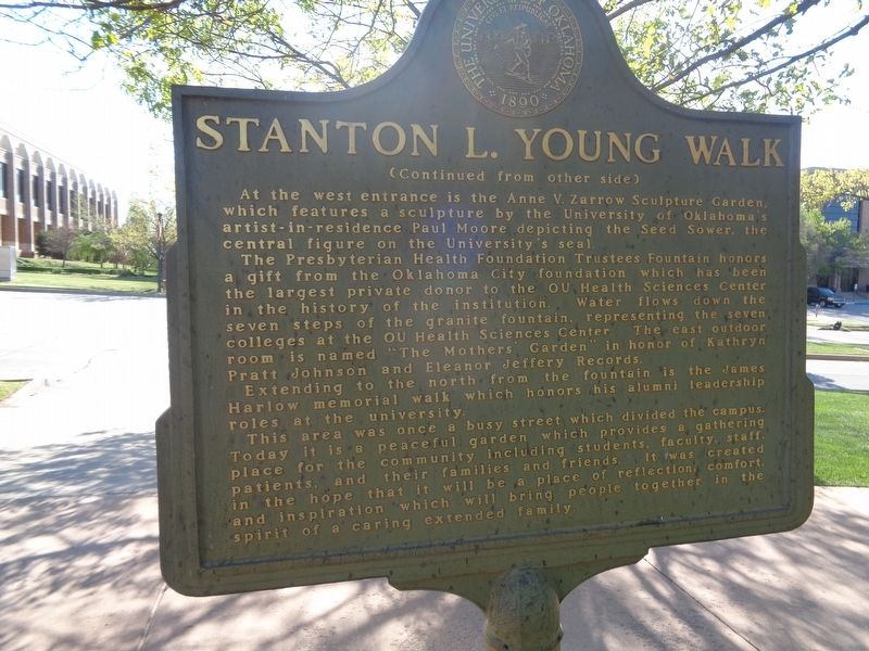
Designed to be focal point of the OU Health Sciences Center campus, the walk honors Oklahoma City businessman, civic leader and humanitarian Stanton L. Young. A native of McAlester, Oklahoma Young graduated from Oklahoma City's Classen High School . . . — — Map (db m172370) HM
On North 5th Street just north of Route 30 overpass (U.S. 30), on the right.
A network of brave humanitarians aided thousands of freedom seekers at this river crossing. Among them was Robert Loney, born enslaved in Virginia circa 1815. Many members of his family are buried here.
"Abraham Johnson, a young slave, hearing . . . — — Map (db m215517) HM
On Avenida de la Constitución/Constitution Avenue (State Highway 25/26) west of C.Reverendo Gerardo Dávila/Rev. Gerardo Dávila St., on the right when traveling east.
Having served as Secretary of Commerce under Presidents William Harding and Calvin Coolidge, President Hoover, educated as a mining engineer, was the last Cabinet secretary to be directly elected President of the United States without . . . — — Map (db m193242) HM
Joseph Hanover came to the United States from Poland at the age of five with his mother. His father had come earlier to begin a new life, save money, and send for them. Later, Hanover became a lawyer in Memphis and served for one term, 1919-1921, in . . . — — Map (db m204807) HM
On Eldridge Parkway, 0.2 miles south of Briar Forest Drive, on the right when traveling south.
Rabindranath Tagore the Nobel Laureate Poet, Philosopher, and Progressive Renaissance Man of India, was the first person from Asia to win the Nobel Prize in Literature in 1913. He is considered the brightest star in the cultural and literary world . . . — — Map (db m199139) HM
On Abe Street (U.S. 87/277) at Washington Drive, on the right when traveling south on Abe Street.
A dedicated member of the Methodist Church and a gifted teacher, Mrs. Massie was a humanitarian who worked to further education throughout her life.
The former Mary Lee Payne, Mrs. Massie was born in Weimar [Texas], one of four children. She . . . — — Map (db m72228) HM
Physician, humanitarian, civil rights advocate and concerned citizen Dr. James Lee Dickey (d. 1959) had a profound effect on the quality of life in his adopted hometown of Taylor. Born in McLennan County in 1893, he attended Waco public schools . . . — — Map (db m3087) HM
On Shell Road at Aberdeen Road when traveling west on Shell Road.
In 1906, the Virginia General Assembly authorized the Virginia School
for Colored Deaf and Blind Children. Founded by deaf humanitarian
William C. Ritter and Hampton Delegate Harry R. Houston, the school
opened on 8 Sept. 1909 to serve . . . — — Map (db m129908) HM
On Kantgasse at Beethovenplatz, on the left when traveling north on Kantgasse.
Von diesem Gebäude aus rettete Dr. Feng Shan Ho, Chinas Generalkonsul zu Wien, in den Jahren 1938 und 1939 nach dem Anschluss und der sogenannten Reichskristallnacht tausende Juden. Sich den Befehlen seiner Vorgesetzten widersetzend . . . — — Map (db m108805) HM
On Avenida Sete de Setembro, 0.1 kilometers south of R. Barão de Itapuã, on the right when traveling south.
Stefan Zweig nasceu em Viena, Áustria, em 1881. Escritor cosmopolita, tornou-se conhecido por suas analises do comlexo psíquico e pela defesa dos ideais humanitarios. Foi o autor mais traduzido do seu tempo. Pacifista, escrevia . . . — — Map (db m31877) HM
In honour of the 100th Anniversary of Rotary International, Rotary Clubs of Halifax are pleased to join Waterfront Development Corporation limited in creating this performance platform and lookoff as a gift to the people of the Halifax . . . — — Map (db m139326) HM
On Alexandria Avenue close to Michigan Avenue, on the left when traveling north.
The Commandant of the United States Coast Guard
Washington 20590
The Secretary of Transportation takes pleasure in presenting the
Gold Life Saving Medal to
Robert Earl Campbell
For acts as set forth in the following Citation
“For extreme . . . — — Map (db m197873) HM
Como un sincero reconocimiento a todas aquellas personas de corazón noble y humanitario que han hecho posible esta obra, muy especialmente la colaboración brindada por AID, Fundacion Habitat y la iniciativa del Club Rotario de Santa Tecla . . . — — Map (db m83574) HM
Holocaust Rescuer who saved tens of thousands of Jews
Wilfrid Berthold Jacob Israel was born into a liberal Jewish family of extreme wealth. His mother, Amy, the granddaughter of the Chief Rabbi of the U.K., Herman Adler, insisted he . . . — — Map (db m228001) HM
Mollie was a resourceful and independent young woman with a wanderlust and love of frontiers. In 1890, she left home at 18 for Butte, Montana where she spent seven years. Landing in Skagway in 1897, Mollie became popular as a waitress and member of . . . — — Map (db m72786) HM
On Taylor Street at Beach Street, on the right when traveling north on Taylor Street.
This heroic statue of the patron Saint of St. Francis de la Varenne was carved in Paris in 1926-1928 out of a 20-ton block of granite, by the great
Italian sculptor, Beniamino "Benny” Bufano. It remained unseen in a warehouse there for 27 years, . . . — — Map (db m177076) HM
A social activist, recognized by Yad Vashem as one of the Righteous Among the Nations, who during World War II saved approximately 2,500 Jewish children.
She was born in 1910 in Warsaw. As a little girl she learned the Yiddish language . . . — — Map (db m200394) HM
On 27th Street Northwest, 0.1 miles north of Q Street Northwest, on the left when traveling north.
Mt. Zion Cemetery
(Old Methodist Burial Ground)
1809 - 1950s
Female Union Band Society
Cemetery
1842 - 1950s
have been listed in the
National Register of Historic Places
by the
United States Department of the . . . — — Map (db m189267) HM
Near N US Highway 301, 0.2 miles south of E Dr. Martin Luther King Jr. Blvd.
Operation Enduring Freedom - Philippines (OEF-P) or Operation Freedom Eagle is part of Operation Enduring Freedom and the U.S. Global War on Terrorism. About 600 U.S. military personnel are advising and assisting the Armed Forces of the Philippines . . . — — Map (db m193312) HM WM
Near U.S. 301, 0.2 miles south of E Dr. Martin Luther King Jr. Blvd.
Operation Uphold Democracy (19 September 1994 - 31 March 1995) was an intervention designed to remove the military regime installed by the 1991 Haitian coup d'état that overthrew the elected President Jean-Bertrand Aristidé. The operation was . . . — — Map (db m207169) WM
Near Unnamed Cemetery Road, 0.1 miles north of Myrtle Street.
Born in Savannah, Georgia, May 15, 1860
Moved to Rome, Georgia, March 1866
Graduated from Rome Female College, 1876
Attended New York Art Students League, 1884-1885
Her father, The Rev. Mr. Samuel Edward Axson was pastor of Rome’s . . . — — Map (db m39430) HM
On South Main Street (U.S. 89) near East 1st South Street, on the right when traveling south.
In honor of
Charles Coulson Rich
1809-1893
Pioneer builder of the west.
Major-General of the Nauvoo Legion
Alderman of the City of Nauvoo, in the time of Joseph Smith.
Pioneer of Utah, 1847.
Chairman of the first committee . . . — — Map (db m105849) HM
On Oak Park Avenue, 0.2 miles north of West Irving Park Road (Illinois Route 19), on the left when traveling north.
This plaque commemorates those individuals buried within Cemetery No. 3, formerly associated with the Cook County Poor Farm, later known as the Read-Dunning Institutional complex, and later Chicago State Hospital. This Cemetery was platted on . . . — — Map (db m245999) HM
On North Lakeview Avenue, on the right when traveling south.
Elks National Memorial Headquarters Building
Egerton Swartwout, architect
1924-26
This building was constructed by the Benevolent and Protective
Order of Elks, an American fraternal organization, in tribute to
the 1,037 Elks who died . . . — — Map (db m188338) HM WM
On South Plymouth Avenue at Elmwood Avenue, on the right when traveling east on South Plymouth Avenue.
Genesee Valley Park
Genesee Valley Park was the second of the original parks in Rochester to be designed by Frederick Law Oldsted. Historic parkland with rolling lawn, groves of mature trees, and placid river views on both sides of the . . . — — Map (db m131882) HM
On East 42nd Street at First Avenue/United Nations Plaza, on the left when traveling west on East 42nd Street.
"It is the future of the whole civilized world which is at stake."
Acceptance Speech as the United Nations Secretary-General, February 2, 1946
This plaza and sculpture honor Norwegian diplomat and humanitarian Trygve Lie, first . . . — — Map (db m165226) HM
On Riverside Drive at West 72nd Street, on the left when traveling north on Riverside Drive.
Riverside Park is one of only eight officially designated scenic landmarks in the City of New York. Rugged bluffs and rocky outcroppings created through prehistoric glacial deposits once descended directly to the Hudson River shore. They were . . . — — Map (db m170420) HM
This C-47, also affectionately known as a "Gooney Bird", represents the History and Mission of the 914th Airlift Wing and the 328th Airlift Squadron. It is displayed in the markings of the 3rd Combat Cargo Squadron. The 3rd CCS pioneered Tactical . . . — — Map (db m75928) HM
The Cold War (1946-1991) Peace Operations (1991-2000) Shortly after its victory in World War II, the United States faced new international security challenges. The Soviet Union established Communist governments in central and eastern Europe and . . . — — Map (db m35504) HM
In 1850, Lucian Lathrop (1800-1873) and his second wife Larissa Titus Lathrop (1803-1878) built this two-story Greek Revival home on South Main Street, where they lived with his children Helen and James Jerome and his mother Azubah Putnam Lathrop. . . . — — Map (db m180989) HM
The Greatest Humanitarian Airlift in History
First Battle of the Cold War
Hoping to force the Allies to abandon Berlin, the Soviet Union instituted a land and water blockade of the city. This was their effort to take control of Germany . . . — — Map (db m183748) HM WM
American Friends Service Committee (AFSC),
is a Quaker-affiliated organization committed
to social justice, peace and humanitarian
service. In 1947, the Nobel Peace Prize was
awarded to the AFSC and the Friends Service
Council for their work to . . . — — Map (db m157434) HM
On North Matlack Street, on the right when traveling north.
David Townsend House
This Property Devised December 1951 by
Marion Hoopes Stevenson
To the
Chester County Historical Society
As a memorial
To her Great-Grandfather
DAVID TOWNSEND
1787 – 1858
Banker, Botanist,
Civic . . . — — Map (db m50314) HM
On Stoney Batter Road, on the left when traveling north.
"To secure for the purpose of a site for a monument … an acre or more of ground at Stony Batter, near Mercersburg, Pennsylvania, the birth place of my uncle James Buchanan, and thereon to erect a suitable monument with proper . . . — — Map (db m58648) HM
On West King Street (Pennsylvania Route 462) at South Prince Street (U.S. 222), on the right when traveling west on West King Street.
Fulton Theatre, directly opposite of this block, is among the nation's oldest continually operating performance halls. When this site was the location of the Lancaster County Jail, a dramatic episode in the Underground Railroad history occurred. The . . . — — Map (db m136439) HM
On West Hill Avenue at Church Street, on the right when traveling east on West Hill Avenue.
Members of the Religious Society of Friends (Quakers) came to Blount County in the 1790s looking for a place to worship in peace. Hardworking and industrious, opposing war and slavery, they developed the land and founded the prosperous settlements . . . — — Map (db m81361) HM
Near Patton Road, 0.2 miles east of Cox Road, on the right when traveling east.
Country music singer, songwriter, actor, film producer, television and radio host, and vintner, Kix Brooks came to prominence as one half of country music's most successful duo of all time, Brooks & Dunn.
Leon Eric "Kix" Brooks III was born in . . . — — Map (db m178375) HM
Near Overlord Circle, 0.4 miles west of Burks Hill Road.
Constituted as VIll Bomber Command to support the invasion of North Africa, the Mighty Eighth was officially born in Savannah, Georgia, on 29 January 1942. Securing approval from the War Department to activate an air force as part of the U.S. Army . . . — — Map (db m241217) WM
On Martin L. King Jr. Way at Jefferson Avenue on Martin L. King Jr. Way.
Groundbreaking for this memorial devoted to Dr. King took place September 10, 2010, as part of Southeast Community Day. The keynote speaker was his daughter and national president of the Southern Christian Leadership Conference, Dr. Bernice A. King. . . . — — Map (db m98324) HM
The Legacy and Heritage of
Second Battalion, 4th Marines
Second to None
The Magnificent Bastards
Small Wars ·
Soldiers from the Sea ·
Old China Marines ·
World War II ·
Cold War Force in Readiness ·
Vietnam ·
Desert Shield · . . . — — Map (db m7309) HM
Alexander Graham Bell,
Teacher of the deaf
Humanitarian and inventor,
Became the first member of
The Telephone Pioneers of America,
On November, 2, 1911.
The Telephone Pioneers of America,
Are proud to dedicate this cairn
To . . . — — Map (db m79993) HM
Near Chebucto Street (Nova Scotia Route 205), on the right when traveling west.
English:
The Park commemorates the humanitarian and scientific achievements of Alexander Graham Bell (1847-1922) and his associates
Frederick W. Baldwin • John A.D. McCurdy • Glenn H. Curtiss • Thomas E. Selfridge
Most of the . . . — — Map (db m80007) HM
On Via Monte di Pietà at Via Privata Fratelli Gaba, on the left when traveling east on Via Monte di Pietà.
Il marchese Luigi Porro Lambertenghi
illustre per iniziative
e per opere umanitarie e patriottiche
abito in questa casa
prima di sottrarsi con l'esilio
ai processi politici del 1821
nei quali veniva condannato a morte . . . — — Map (db m218951) HM
On East Mobile Street at North Royal Avenue, on the left when traveling south on East Mobile Street.
The United States flag that flies at the base of this hill stands as a sentry over the site that was the home of Fort Willingham Armory from 1937-1979. The Armory was named after Dr. Henry J. Willingham, president of Florence State Normal School, . . . — — Map (db m83987) HM
On Harbor Drive at Maksoutoff Street, on the left when traveling west on Harbor Drive.
The 'Cottage-by-the Sea' was constructed in 1897 by Norwegian prospector Captain Hans Christian Pande. While Alaska was still a Territory, the W.P. Mills Company donated this house to the Sitka Woman's Club for a clubhouse, which led to the . . . — — Map (db m241980) HM
On U.S. 63/79, 0.1 miles north of Myrtle Street, on the right when traveling north.
The Arkansas Flag/Wabbaseka Memorial was founded by Jason Irby in 2013. Jason is an author and humanitarian who grew up in Wabbaseka and attended the public schools around the city. Jason attended Willie K. Hocker Elementary/Jr. High schools, . . . — — Map (db m169051) HM
On 22nd Street Northeast at East Capitol Street Northeast, on the right when traveling north on 22nd Street Northeast.
"The Old Fox"
Clark Calvin Griffith
Born Clear Creek, Missouri
November 20, 1869
Pitcher - Manager - Owner
Member of Hall of Fame
Won 237 — . . . — — Map (db m15615) HM
On K Street Northwest (U.S. 29) at 11th Street Northwest (U.S. 29), on the right when traveling east on K Street Northwest. Reported permanently removed.
"...watch yourselves closely
so that you do not forget the things
your eyes have seen...
...teach them
to your children
and to their children
and to their children after them."
Deuteronomy 4:9
Stories . . . — — Map (db m70316) HM
On Silver Beach Avenue, 0.3 miles east of City Island Parkway, on the right when traveling west.
Operation Just Cause
1989
The United States invasion of Panama led to the capture of Dictator Manuel Noriega, and the restoration of a democratic government.
Total Active Serving 27,684
Killed In Action 23
Wounded In Action 324 . . . — — Map (db m154953) WM
"Georgian of the Year" by the
Georgia Association of Broadcasters, 1984
"Sports Administrator of the Year" by the State of Georgia Sports Hall of Fame, 1984
Georgia Trend Magazine
Top 100 Georgians of the Century, 2000
NACDA Division I-A . . . — — Map (db m221605) HM
On Franklin Street, 0.1 miles south of Lake Shore Drive, on the right when traveling south.
Roger McKee was a talented and visionary civic leader. This fountain
is dedicated to his decades of public service and humanitarian causes.
His proudest accomplishments were the preservation of the land
which this Millennium Plaza is located . . . — — Map (db m163391) HM
On 6th Street at Washington Street, on the right when traveling east on 6th Street.
Mary Ann Ball was born near Mount Vernon, Ohio in 1817. She married Robert Bickerdyke in 1847 and they moved to Galesburg, Illinois.
At the outbreak of the Civil War the residents of Galesburg purchased medical supplies worth $500 for soldiers . . . — — Map (db m95499) HM
Born February 10, 1967 - New Roads, Louisiana
EDUCATION
Louisiana State University - Bachelor's Degree in Kinesiology
United States Army College Mss Strategic Studies
1990 ROTC 2nd Lt. Commission
1998 Lt. Col. Transfer from Army to . . . — — Map (db m238267) HM
On Brooke Road, 0.1 miles west of Chandlee Mill Road, on the right when traveling west.
Harridays and Carrolls
Joseph Harriday was born on November 29, 1953 to the late Archie "Jerry" Bell and the late Sadie Harriday, died on Friday, August 30, 2019 in his home in Germantown, MD. Joe loved watching the "Andy . . . — — Map (db m188347) HM
On County Highway 419, 0.7 miles east of County Highway 80, on the left when traveling east.
(Side 1)
Formed in 1987 when three local musicians — Joe Lee Huffman, Willie Gene Huffman, and Robert Eaton — got together to play music and share supper, the Sparta Opry has become a community institution. Having offered more than 100 country, . . . — — Map (db m155271) HM
On Centre Street near Worth Street, on the left when traveling north.
This park in the heart of New York City’s civic center is named for patriot, author, humanitarian, and political visionary Thomas Paine (1737-1809). The land that is now Thomas Paine Park was once part of a freshwater swamp surrounded, . . . — — Map (db m129041) HM
On East Water Street east of Court Street, on the right when traveling east.
Granite Monument erected September 17, 2017, Honors
Hugh Williamson, son of Scotch-Irish parents, was born 1735. in Nottingham, Pennsylvania. His parents wanted him to become a Presbyterian minister, but his quest for knowledge took him in . . . — — Map (db m225261) HM
On East Market Street, on the right when traveling west.
Dedicated in Memory of
Dr. Ronald E. McNair
1950 - 1986
• Astronaut
• Scientist
• Humanitarian
"A genuine American Hero who
carried the name of A & T State
University magnificently to the
far corners of the universe." . . . — — Map (db m221866) HM
On Market Street at South Street, on the right when traveling north on Market Street.
Quakers and Wars During the 1900s
The 1900s saw warfare and humanitarian atrocities around the globe. Quakers were caught in the middle. During World War I, thousands of American men, including Quakers, were drafted. Quakers do . . . — — Map (db m196276) HM
On North River Road, 0.4 miles west of Mohawk Place, on the right when traveling north.
Rotary
International
(1905-2005)
Rotary is a worldwide organization
of business and professional
leaders that provides humanitarian
service. encourages high ethical
standards in all vocations, and
helps build goodwill and peace . . . — — Map (db m173204) HM
On Broadus Avenue at East Washington Street, on the right when traveling south on Broadus Avenue.
Upper Plaque:
Dedicated to the memory
of
Dr. William Thomas Brockman
A distinguished Surgeon
-- Humanitarian --
Churchman
Citizen and Commissioner of the City of
Greenville, South Carolina
1881 ---- 1968
Lower . . . — — Map (db m17503) HM
On West Court Avenue (Business U.S. 64) west of North 3rd Street, on the right when traveling west.
Carl Perkins
American Music Icon • King of Rockabilly
Carl Perkins is a native of Lake County, Tennessee and a towering figure in American popular music. He achieved superstardom in 1956 with the rockabilly anthem "Blue Suede Shoes," but . . . — — Map (db m179091) HM
(Front):
To
Hunter Holmes McGuire, M.D., LL.D.,
President of the American Medical
and of the
American Surgical Associations;
Founder of the University College of Medicine;
Medical Director, Jackson's Corps,
Army of Northern . . . — — Map (db m4735) HM
On Packer Drive, on the right when traveling west.
Quarterback 1956 to 1971
Head Coach 1975 to 1983
6 Conference Championships
5 NFL Championships
Pro Bowl Team 1961,62,63,67
All Pro Selection 1961,62,64,66
MVP Super Bowl 1
MVP Super Bowl 2
NFL MVP 1966
Elected to Pro . . . — — Map (db m39251) HM
On Main Street of Delhi at Eagle Street, on the left when traveling north on Main Street of Delhi.
[photo captions] 1. Circa 1958, looking east, many of the stores built circa early 1950s. First store from left, Taggarts Ladies Wear (previously Coni's Photography). Second from left, Mayberry S. (Stewart) Shoes. Third from left, Liquor . . . — — Map (db m237200) HM
On Paseo de Gracia, on the right when traveling north.
(Catalan:)
En aquest edifici, durant la guerra civil
de 1936-1939, va radicar la delegació
d'euzkadi a catalunya, que tant va
contribuir a les relacions de fraterna
amistat entre ambdos països i que va dur
a terme una meritissima . . . — — Map (db m216696) HM
On Day Street at Community Street, on the right when traveling east on Day Street.
Born December 24, 1940, in Chambers County, John L. Alford Sr. was
an educator, clergyman, humanitarian, and civil rights leader. After
graduating from high school in Lanett, he attended Alabama State
University and Selma University, earning . . . — — Map (db m194772) HM
Near Figueroa Street south of Exposition Boulevard, on the right when traveling south.
No event in track and field is more challenging, physically or mentally, than the decathlon.
1955 · UCLA freshman Rafer won the Pan American Games decathlon in Mexico City.
1954-58 · He competed under UCLA coaches Craig Dixon and . . . — — Map (db m238101) HM
the two markers are attached to a flag poleUpper Marker
Julian
This marker placed in memory
of
Mrs. Ida B. Wellington
May 25, 1887 – Dec. 16, 1962
Historian – Humanitarian
Daughter of Drury Bailey who . . . — — Map (db m82393) HM
On K Street Northwest (U.S. 29) at 11th Street Northwest, on the left when traveling west on K Street Northwest.
"…watch yourselves closely
so that you do not forget the things
your eyes have seen…
…teach them
to your children
and to their children
and to their children
after them."
Deuteronomy 4:19
On South Martin Luther King Jr Boulevard at FAMU Way, on the right when traveling south on South Martin Luther King Jr Boulevard.
"Freedom is never voluntarily given by the oppressor; it must be demanded by the oppressed." -Dr. Martin Luther King, Jr.
Dr. Martin Luther King, Jr. (1929 - 1968) was an African American Baptist minister, activist, . . . — — Map (db m230574) HM
2016 Recipient of the Coach John Wooden Citizenship Cup
for service to others
2014 Recipient of the Bobby Bowden Lifetime Achievement Award
“Over The Mountain Touchdown Club", Birmingham, Alabama
2013 Recipient of the Kennesaw State . . . — — Map (db m199031) HM
On Newcastle Street north of Mansfield Street, on the right when traveling north.
British humanitarian, leader and military commander, James Edward Oglethorpe (1696-1785), is credited as the founder of Georgia. His plan for the city of Savannah, later adapted for the design of Brunswick, included ample public green space. His . . . — — Map (db m212676) HM
On North 400 East, 0.3 miles south of East 700 North, on the right when traveling south.
American Eagle Flight 4184
October 31, 1994
American Eagle Flight 4184 departed Indianapolis at 2:55 PM CST on October 31, 1994, en route to Chicago's O'Hare International Airport. There were 64 passengers and 4 crew members aboard the . . . — — Map (db m231129) HM
On Old Fort Boulevard at Main Street, in the median on Old Fort Boulevard.
Gordon Parks was born on November 20, 1912 in Fort Scott, Kansas to Sarah and Andrew Jackson Parks. Gordon wrote, "Poppa was a dirt farmer who farmed mostly dirt, but he kept us alive and taught us about love and devotion." The youngest of 15 . . . — — Map (db m128781) HM
Organized in October of 1952 by a group of educators who
worked at Washington Elementary School. The mission of the
organization is to provide humanitarian services to enhance
community life. The biennial debutante ball is a social . . . — — Map (db m236663) HM
On 3rd Street near E Street, on the left when traveling north.
Type: Utility and Medical Evacuation; 3,880 lb cargo, 10 troops or 6 stretchers
Manufacturer: Bell Helicopter
Engine: Single Turboshaft
Max Speed: 142 mph
Range: 287 miles
Number Built:
more than 16,000
Crew: 1-4
The UH-1 was . . . — — Map (db m213284) HM
On Piccard Drive west of Pleasant Drive, on the right when traveling west.
"Peace is possible ... it can begin simply, over a game of chess and a cup of tea."
Mattie J.T. Stepanek
July 17, 1990 - June 22, 2004
Mattie enjoyed public speaking and worked with Former President and First Lady Jimmy and . . . — — Map (db m129439) HM
On Church Avenue at West 26th Street, on the right when traveling west on Church Avenue.
Side A
Called “Station Hope” by many freedom seekers on the
Underground Railroad, St. John’s was one of their final stops.
Though aiding freedom seekers was a crime and often could
not be described in public documents, Sheila T. . . . — — Map (db m140134) HM
On Ohio Route 23 at Stoney Creek R0ad (Ohio Route 372), on the right when traveling north on State Route 23.
The first known attempt to assist a runaway slave in Ross County
was recorded in 1815, when local residents assisted a slave to
safety in Franklin County. Quakers, the Presbyterians and African
Americans were the principal participants who . . . — — Map (db m146892) HM
Almighty God, from this pulpit of stone the American people render thanksgiving and praise for the new era of civilization brought forth upon this continent. Centuries of tyrannical oppression sent to these shores, God-fearing men to seek in freedom . . . — — Map (db m89493) HM
With compassion for others
We build ~ We fight
For peace with freedom
(On the frieze behind the statue):
With willing hearts and skillful hands, the difficult we do at once; the impossible takes a bit longer
(On the panel to . . . — — Map (db m4925) WM
On Main Street (Arkansas Route 59) east of Cane Hill Street, on the right when traveling east.
The military history of the United States spans a period of more than two centuries. During these years, the United States evolved from a new nation fighting Great Britain for independence (1775-1783), through the monumental American Civil War . . . — — Map (db m244110) HM WM
On Pier 94 east of the Catalina Air-Sea Terminal Heliport.
Panel 1:
1945:
March: Lane Victory is named for the former slave, Isaac Lane, founder of Lane College, in Jackson, Tennessee. The Victory Ship was one of a class of cargo ships designed and built during World War II by the . . . — — Map (db m131429) HM
On Boronda Road at Calle Del Adobe, on the left when traveling north on Boronda Road.
[First Plaque:]
On the morning of February 18th, 1941, one hundred and five brave men of Company C 194th Tank Battalion of the Salinas and Pajaro Valleys marched four abreast down Main Street, through what is now called Old town Salinas, . . . — — Map (db m60395) HM
On West North Street just north of South Governors Avenue (Alternate U.S. 13), on the left when traveling west.
The Old State House
Fact: After the capital was moved from New Castle to Dover in 1777, the State House was built as the first permanent capitol building in 1787 and finished in 1791.
Information: This Georgian . . . — — Map (db m227860) HM
Near Heritage Road, 0.7 miles west of Bayside Drive (Delaware Route 9), on the left when traveling west.
The museum's C-45 was the first obtained by the Central Intelligence Agency (CIA)
The C-45 is the military version of the popular Beechcraft Model 18 commercial light transport. Beech built a total of 4,526 of these aircraft . . . — — Map (db m142622) HM
[West Face]:
Northeast of this spot stood the famous Sunbury Oak of early Colonial Masonic legend. The tree is said to have been of tremendous size and provided an ideal
place for safe, comfortable campsites.
The legend of the . . . — — Map (db m9481) HM
[Marker Front]:
One of Georgia's two signers of the United States Constitution.
Born in Baltimore, Maryland June 18, 1748.
Lieutenant Colonel, Georgia Militia during the American Revolution, 1776-1770.
Representative, Georgia . . . — — Map (db m10108) HM
On North Vermilion Street at North Street, on the left when traveling north on North Vermilion Street.
“The Temple” - Plaque
Completed in 1901, the Temple Building occupied this site for 100 years. In 1879 members of the Olive Branch Lodge bought the corner lot at Vermilion and North Streets for a new Masonic Temple. The . . . — — Map (db m37000) HM
Near Old Guilford Road, 0 miles south of Guilford Road.
History
Once, a thriving community prospered here along the banks of the Little Patuxent River. Guilford was a center for milling, quarrying, and cotton=cloth production in the late 18th through the early 20th centuries. It featured . . . — — Map (db m19884) HM
On East Church Street (State Highway 52) at South Main Street (State Highway 52), on the right when traveling east on East Church Street.
Laura Haviland, affectionately known as Aunt Laura, is probably the best-known and most-admired person who ever lived in Lenawee County. The reason for this admiration and acclaim lies in Mrs. Haviland's life-long devotion to helping others and in . . . — — Map (db m169285) HM
On Bald Hill Road, 0.1 miles north of Weber Drive, on the right when traveling north.
Located just south of downtown Eureka, Lions Park is named for the Eureka Lions Club and honors its community service and fundraising efforts for the Eureka area. Lions Club's generous donation helped established the athletic fields within the . . . — — Map (db m157385) HM
On N. Clinton Street (Ohio Route 66), on the right when traveling north.
On May 5, 1945, the American troops commanded by
COl. Richard R. Seibel entered Mauthausen in
Austria, bringing freedom to 18,000 prisoners still
alive in the final Nazi death camp.
A famous Holocaust picture was taken that day by a
U.S. Army . . . — — Map (db m171217) HM
On 3rd Street south of Broad Street (U.S. 40), on the right when traveling south.
The Underground Railroad was neither underground nor a
railroad, but a system of loosely connected safe havens
where those escaping the brutal conditions of slavery
were sheltered, fed, clothed, nursed, concealed, disguised,
and instructed . . . — — Map (db m10251) HM
On West Maumee Avenue (County Road Z) west of Huddle Road, on the right when traveling west.
Our History
1917: Chicago business leader Melvin Jones asked a simple and world-changing question - what if people put their talents to work improving their communities? Almost 100 years later, Lions Clubs International is the world's . . . — — Map (db m183329) HM