On Monument Drive at Miriam Lane, on the right when traveling south on Monument Drive.
The pioneer settlers named below were massacred by Sioux Indians March 8 to 13 1857. This barbarous work was commenced near this spot and continued to Springfield now Jackson Minn.
Robert Clark ·
Rowland Gardner ·
Frances . . . — — Map (db m245504) HM
On Military Avenue (U.S. 69), on the right when traveling south.
On Oct. 6, 1863, Gen. James Blunt and about 125 men from the 3rd Wisc. Cav. and the 14th Kans. Cav. stopped at the creek before coming into Ft. Blair. They were caught in a surprise attack from the rebel forces of William Quantrill. Nearly 100 of . . . — — Map (db m80214) HM
On Park Avenue at 10th Street, on the left when traveling north on Park Avenue.
Dedicated in memory of General James G. Blunt and his escort who defenseless, fell victims to the inhuman ferocity of guerrillas, led by the infamous Quantrell in his raid upon Baxter Springs October 6th 1863, in which 135 Union soldiers were slain . . . — — Map (db m80348) HM
On U.S. 69/400, 0.2 miles south of SE Varck Road, on the right when traveling south.
On October 6, 1863, Gen. James Blunt and about 100 men were met near Baxter’s springs by William Quantrill and several hundred Confederates masquerading as Union troops. As Blunt’s band was preparing a musical salute the enemy fired. This surprise . . . — — Map (db m37840) HM
On 6th Street near Military Avenue (U.S. 69), on the left when traveling east.
First burial site for victims of the Baxter Springs Massacre and the attack on Ft. Blair. In 1869, the bodies were moved to the National Cemetary plot west of town. — — Map (db m37836) HM
On U.S. 400 near State Highway 66, on the right when traveling south.
Headquartered in Fort Scott, Union Major General James G. Blunt was the highly recognized commander of the District of the Frontier. In 1863, Blunt decided his force needed to be closer to the gathering Confederate forces in the South and headed out . . . — — Map (db m170743) HM
Nothing in the struggle over slavery in Kansas did more to inflame the nation than the mass killing which took place May 19, 1858, about four miles northeast of this marker. Charles Hamelton who had been driven from the territory by Free-State men, . . . — — Map (db m4359) HM
A Nation at Odds
The mid 1800s were a time of turmoil and tragedy in the U.S. The issue of slavery polarized the nation. It created a moral, political, and economic dilemma. The struggle over slavery ultimately led to the Civil War, splitting . . . — — Map (db m39862) HM
On County Route 28 at 77, on the right when traveling north on County Route 28.
About July 1, 1867, Lt. Lyman S. Kidder with ten men of the 2nd U.S. Cavalry, and an Indian guide, were attacked by Indians one mile east of this marker. On July 12 their mutilated bodies were found by Lt. Col. George A. Custer, who ordered the . . . — — Map (db m78880) HM
On Westvaco Road (U.S. 51/62), on the right when traveling south.
Fort Jefferson Site Built in 1780 by George Rogers Clark as part of impressive plan of settlement, conceived by Gov. Patrick Henry of Virginia, later pursued by and named for Gov. Thomas Jefferson. The fort was to protect US claim to its . . . — — Map (db m18639) HM
On West Hebron Lane, 0.1 miles south of John Harper Highway (Kentucky Route 1526), on the left when traveling south.
Brooks' Spring
The spring here, first called Stewart's or Phillips' and then Brooks' Spring, was a well-known camping place in the early 1780s on the main route from the Falls of the Ohio & Beargrass Creek to Bullitt's Lick and Harrodsburg. . . . — — Map (db m174479) HM
On Violet Rd (Kentucky Route 491), on the left when traveling west.
Three miles west. Reputedly scene of one of last massacres in Ky. McClures and Kennedy's lived on hills above Bullocks pen creek and the Bran family occupied cabin on creek at foot of hills. Around 1805, party of Indians burned the Bran home after . . . — — Map (db m82149) HM
On Shelbyville Road (U.S. 60) west of Arlington Meadows Drive, on the right when traveling west.
One mile south. Scene of massacre, undoubtedly the bloodiest in early Kentucky, which took place, 1781. A Miami Indian party killed over 60 pioneers en route from Squire Boone's Painted Stone Station to safety of forts at Falls of Ohio. Next day, . . . — — Map (db m161771) HM
About 500 yards southeast of Pound Gap, along the Fincastle Trail (Virginia side) is the location of the infamous “killing rock” where the Mullins’ family and friends were massacred on May 14, 1892. Five people were killed: Ira Mullins, . . . — — Map (db m90801) HM
On Old Beaver Road (Route 1274) at Big Woods Road, on the right when traveling west on Old Beaver Road.
In April 1793, thirty-five Indians
attacked Morgan’s Station, a fort
in Montgomery County, and captured
nineteen residents. Pursued by
a group of settlers, the Indians
killed some captives at Murder
Branch in Menifee County. After
a skirmish . . . — — Map (db m146651) HM
On Shelbyville Road (U.S. 60) at Webb Road, on the right when traveling east on Shelbyville Road.
"Horrible Massacre"
On January 25, 1865, Co. E. 5th United States Colored Calvary (USCC) attacked by Confederate guerillas while driving herd of 900 cattle to Louisville. About 22 men killed and at least eight severely wounded. Based at Camp . . . — — Map (db m136842) HM
On President Street at Aliceanna Street, in the median on President Street.
In 1918, Poland regained her independence, after enduring three partitions and domination for 123 years by Russia, Prussia, and Austria. Barely 21 years later, on September 1, 1939 Nazi Germany invaded Poland from the west, triggering the Second . . . — — Map (db m183378) HM
On North Street, 0.2 miles north of Meadowview Road when traveling north.
Ten rods east stood the
house of Benjamin Goodrich
who, with his wife and two
children, was slain by the
Indians on October 23, 1692 — — Map (db m47864) HM
On Albany Rd at Old Main Street, on the left when traveling north on Albany Rd.
Feb 29, 1703-4
The unfortified house of Benoni Stebbins
standing on this lot was held by
7 men besides women and children
for three hours
against the assault of 200 soldiers
and the wiles of 140 Indians.
under a French . . . — — Map (db m141156) HM
On Tremont Street south of West Street, on the right when traveling south.
Crispus Attucks • Samuel Maverick • James Caldwell • Samuel Gray • Patrick Carr
From that moment we may date the severance of the British Empire.
Daniel Webster
On that night the foundation of American Independence was . . . — — Map (db m215093) HM WM
On Congress Street east of Dorchester Avenue, on the right when traveling west.
Boston Massacre 1770
Many Bostonians resented the presence and abuses of such a large military force in their midst, hostility grew rapidly, and there were frequent brawls between workers and soldiers. On the night of March 5, 1770, Captain . . . — — Map (db m215503) HM
On Tremont Street at Bromfield Street, on the left when traveling north on Tremont Street. Reported missing.
From 1769-1776 Boston was the flashpoint for events leading up to the American Revolution. On February 22, 1770, a crowd gathered around the house and shop of a Tory sympathizer and customs agent, Ebenezer Richardson. When they started pelting the . . . — — Map (db m18766) HM
On Tremont Street, on the left when traveling north.
The remains of Samuel Gray Samuel Maverick James Caldwell Crispus Attucks and Patrick Carr Victims of the Boston Massacre, March 5th, 1770, were here interred by order of the Town of Boston. ---------- Here also lies buried the body of . . . — — Map (db m19282) HM
On Devonshire Street at State Street on Devonshire Street.
On March 5, 1770, in the street before you, nine British soldiers were confronted by an angry mob."The soldiers did fire without orders and killed five of his Majesty's good subjects...How fatal are the effects of posting a standing army among a . . . — — Map (db m76632) HM
On Massachusetts Route 12, 0.1 miles Johnson Lane, on the right when traveling south.
John Johnson and three children were killed by Indians in his house on this spot August 25, 1696. His wife was saved by her brother. — — Map (db m48785) HM
On Windmill Pointe Drive at Lakepointe Street, on the left when traveling west on Windmill Pointe Drive.
Encouraged by a potential alliance with the English, the Fox Indians besieged Fort Pontchartrain, Detroit, in 1712. Repulsed by the French and their Huron and Ottawa Indian allies, the Fox retreated and entrenched themselves in this area known as . . . — — Map (db m175027) HM
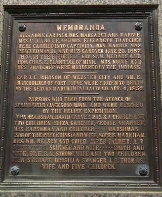
On Riverside Drive, 0.1 miles west of State Street, on the left when traveling west.
Erected by the State of Minnesota
in the year 1909, to the memory of the pioneer setters of Jackson County, whose names are inscribed below, massacred by the Sioux Indians on March 26th, 1857, and August 24th, 1862.
1857 Massacre
William . . . — — Map (db m205190) HM
On Riverside Drive, 0.1 miles west of State Street, on the left when traveling west.
Olson Slaabakken Cabin
Emmet Olson donated this cabin to the city of Jackson in 1926. The cabin is said to have been the first cabin occupied by the family of Engebret Olson when they arrived in Jackson County in 1860. He said that he traded a . . . — — Map (db m205193) HM
Near 3rd Avenue Southwest east of Oak Street South, on the right when traveling east.
Rev. Andrew Jackson had two services arranged in his Norway Lake Swedish Lutheran Parish for Wednesday, the 20th of August, 1862. In the forenoon a meeting was held at the Lundborg cabin at West Lake, now known as Monson Lake in Swift County. Here a . . . — — Map (db m79405) HM
Near International Drive (Highway 72) 0.2 miles north of 3rd Street Northeast, on the right when traveling north.
Tradition is woven of fact and fiction. Two islands in the Lake of the Woods are named “Massacre,” one on the Canadian, one on the American side of the boundary. The Canadian island, the larger of the two, is heavily wooded. The American island . . . — — Map (db m207138) HM
On Division Street West (County Highway 32) east of State Highway 15, on the right when traveling west.
About 1200 feet north-east of this point stood the pioneer log cabin of Samuel White.
There on September 22, 1862, Samuel and his wife Laura, and two children, Susan and Otis were brutally murdered by a small party of Sioux Indians . . . — — Map (db m69995) HM WM
On Unnamed park road north of 15th Street NE (County Highway 95), on the right when traveling north.
This marks the spot where the first Indian massacre took place in this immediate locality August 20th 1862. For further information see Kandiyohi County history. This immemorial erected by P. Broberg being one of the remnants of the massacre. — — Map (db m199592) HM
On 60th Street SW (U.S. 12) 0.4 miles west of Keats Avenue SW, on the right when traveling west.
A state of terror prevailed on the Minnesota western frontier for many months after the Sioux Uprising of 1862. Roving bands of Sioux continued to elude pursuers and attack settlers. The Dustin massacre occurred on June 29, 1863, one third mile . . . — — Map (db m69855) HM
On West Northside Drive, 0.2 miles west of Vernon Road, on the left when traveling west.
On September 4, 1875, a political rally and
debate turned violent on the grounds of the
former Moss Hill plantation, near downtown
Clinton. An exchange of gunfire between White
Democrats and Black Republicans left seven
dead and dozens . . . — — Map (db m184616) HM
RAYMOND J. CAFFREY
Special Agent, Federal Bureau of Investigation
OTTO REED
Chief of Police, McAlester, Oklahoma
WILLIAM J. GROOMS
Detective, Kansas City Missouri Police Department
FRANK HERMANSON
Detective, Kansas City Missouri Police . . . — — Map (db m19942) HM
On Main Street (Missouri Route 23) at SW 6th Street, on the right when traveling south on Main Street.
Side A: Massacre Site
On August 22, 1861, "State Guard" troops under Col. Edwin W. Price plundered this community taking household goods, farm animals and merchandise from Brockhoff's Store.
Sunday, Oct. 5, 1862, sixty drunken . . . — — Map (db m43980) HM
On West Lafayette Street at South Dickerson Street, on the right when traveling west on West Lafayette Street.
The Palmyra Massacre
The Palmyra Massacre was a grim ending to Confederate Col. Joseph Porter's 1862 recruiting campaign in northeast Missouri. Besides recruiting local men for the Confederate army, Porter attacked Union outposts and patrols . . . — — Map (db m55390) HM
On Circle Drive east of Bundy Drive, on the left when traveling east.
These U.S. prisoners of war of the Japanese were on the island of Palawan, P.I. as slave laborers building an airfield for the Japanese military. Believing that an invasion by the U.S. forces was imminent, the prisoners were forced into three tunnel . . . — — Map (db m124984) HM WM
On U.S. 87 near Lower Marias/Loma Ferry Roads, on the left when traveling north.
Erected by J.H. Friend's Family Descendants of Franklin Friend
for the
Victims of Blood Indian Massacre May 25, 1865
Franklin Friend - George W. Friend
Abraham Lotts - John Alley
John Andrews - N.W. Burris
Frank Angeline - Henry . . . — — Map (db m142490) HM
On U.S. 2 at milepost 283 near Kraft Road, on the left when traveling east.
On January, 23, 1870, soldiers commanded by Colonel Eugene Baker killed 173 Blackfeet Indians in a surprise attack on Heavy Runner's camp near here on the Marias 1869. A man of peace, Heavy Runner had no quarrel with the US Army. His people did not . . . — — Map (db m161387) HM
On U.S. 34 near Old Highway 34, on the right when traveling east.
The adjacent stone monument erected in 1930 was first placed about a mile south of this area. Originally on the highway overlooking the canyon, it was moved to this location after the highway was relocated.
Massacre Canyon is the large canyon . . . — — Map (db m79361) HM
An early morning attack on a train of 12 wagons at this spot resulted in the death of 11 men and the capture of Mrs. Thomas Morton and 9 year old Danny Marble. The attack was by Indian “Dog Soldiers” of the Cheyenne Tribe led by Chief . . . — — Map (db m62794) HM
On the morning of August 8, 1864, a war party of Cheyenne and Arapaho Indians attacked a Denver-bound freight wagon train killing thirteen men and taking captive Nancy Jane Morton of Sidney, Iowa, and nine-year old Daniel Marble of Council Bluffs, . . . — — Map (db m107476) WM
Giovanni Pedroni Marcellus Locatelli Teodoro Zesta Pompeo Pattini Antonio Canonica
Charcoal Burners Massacred Aug. 18, 1879 By A Sheriff's Posse Southwest Of The Fish Creek Ranch — — Map (db m89510) HM
On Newmarket Road (New Hampshire Route 108), on the right when traveling west. Reported permanently removed.
On July 18, 1694, a force of about 250 Indians under the command of a French Soldier, de Villieu, attacked settlements in this area on both sides of the Oyster River, killing or capturing approximately 100 settlers, destroying five garrison houses . . . — — Map (db m242885) HM
On Red Oak Drive at Rivervale Road, on the right when traveling east on Red Oak Drive.
Late one night in 1778, the woods you are standing in suddenly echoed with the sounds of battle. A surprise attack by British soldiers nearly destroyed an American regiment, Baylor’s 3rd Continental Light Dragoons. Today, this park tells the story . . . — — Map (db m8455) HM
On Red Oak Drive, on the right when traveling east.
The evening of September 27, 1778, found Baylor’s Dragoons settling for the night near this site. The neighborhood’s name, Overkill, came from the small bridge “Over de kill”, a kill being a creek or river to the Jersey Dutch settlers. It . . . — — Map (db m8454) HM
On Red Oak Drive at Rivervale Road, on the right when traveling east on Red Oak Drive.
“This millstone is the only visible marker of the Baylor Massacre in existence today. On September 28, 1778, a detail of Baylor’s Continental Dragoons camping at Haring’s Tannery in River Vale was betrayed into the hands of the British by a Tory . . . — — Map (db m7876) HM
On Red Oak Drive at Rivervale Road, on the right when traveling east on Red Oak Drive.
In memory of American soldiers killed during the Revolutionary War in the “Baylor Massacre” on September 28, 1778. Lt. Col. George Baylor’s 3rd Regiment of Continental Dragoons took quarters for the night on several nearby farms. Tories betrayed . . . — — Map (db m7874) HM
Here as they slept at dawn on Sept. 28, 1778 Col. Geo. Baylor and 116 Virginia Dragoons were attacked by the British under General "No Flint" Grey. Major Clough, Surgeon George Evans, with fifty other Colonial troopers were killed. — — Map (db m55831) HM
October 25, 1782, a British vessel ran aground near Barnegat City and was captured by patriot militiamen under Capt. Andrew Steelman. That night, while sleeping on the beach, Steelman and his men were massacred by Tory raiders led by John Bacon. — — Map (db m34603) HM
On New Street at Locust Island Road, on the right when traveling south on New Street.
The winter of 1777 – 1778 had been particularly harsh on both the British and the Colonial troops. British commanders learned that the rich agricultural supplies in lower New Jersey could be obtained with little resistance and sent detachments . . . — — Map (db m21604) HM
On Front Street at Locust Island Road, on the left when traveling south on Front Street.
In commemoration of the patriots massacred in the Hancock House March 21, 1778. Erected by the Patriotic Order Sons of America of Salem County July 2, 1932. — — Map (db m21592) HM
On River Road (New York State Route 384) north of Wheatfield Street, on the left when traveling north.
On December 23, 1941, with the fall of the island garrison, the Japanese captured 1,603 men. 1,150 were civilian contractors employed by Morrison-Knudsen Co. they were part of the Contractors Pacific Naval Bases who were hired to build air, . . . — — Map (db m162384) HM
Cherry Valley
Sacred to the Memory
Of Those who Died by
Massacre
In the Destruction of this Village
At the Hands of the Indians & Tories
Under Brant & Butler,
Nov. 11. AD. 1778
— — Map (db m154638) HM
On Front Street at North Church Street, on the right when traveling east on Front Street.
Commemorating Massacre of Feb. 8-9,1690. One Hundred and Fourteen French and Ninety-Six Indians Entered During Night at North Gate, Located at this Point. Assault was Commenced Here. Seventy Houses were Burned, Sixty Persons Killed and . . . — — Map (db m77520) HM
On Main Street (U.S. 209) north of Aluminum Drive, on the right when traveling north.
Bevier Family
Widow Elizabeth Bevier Age 62
Her Sons
Solomon Age 29 • Josiah Age 23
——————
Sax Family
Widow Johannah Sax Age 59 . . . — — Map (db m118476) HM
On McConnell Road at Dunbar Street, on the right when traveling west on McConnell Road.
Ku Klux Klan members and American Nazis, on Nov. 3. 1979, shot and killed five Communist Workers Party members one-tenth mile north. — — Map (db m219790) HM
On Chestnut Street, on the right when traveling east.
Around the spring nearby, was perpetrated, on April 20, 1781, the massacre of 20 Indians by Col. Daniel Broadhead's army of 300. This slaying was committed following destruction, the same day, of the two villages, Goschachgunk, (Coshocton) and . . . — — Map (db m14707) HM
On Fort Site Street just south of West Boundary Street, on the right when traveling south.
On November 4, 1791 on this triangle of land between the rivers, Indian forces under Chief Little Turtle (Miamis) and Blue Jacket (Shawnees), surrounded General Arthur St. Clair's troops. Of his 1,200 soldiers, 900 were killed. It was the worst . . . — — Map (db m165768) HM
In memory of
Henry and Barbara Dilbone
who were killed by the Indians
on their farm to the north
August 18th, 1813
Buried at this place — — Map (db m29840) HM
On Ohio Route 266, on the right when traveling south.
Following the American Revolution, the new Federal government, in need of operating funds, sold millions of acres of western lands to land companies. One such company, the Ohio Company of Associates, brought settlement to Marietta in 1788. Two years . . . — — Map (db m16713) HM
Near South Cherry Street, 0.2 miles south of West Indian Street.
Gnadenhutten
The Moravian Church in America began missionary work among the Delaware and Mohican tribes of North America in the mid-18th century. David Zeisberger, one of the best-known Moravian missionaries, came to the Ohio country with . . . — — Map (db m224977) HM
On Fremont Pike (U.S. 20) at Bradner Road (County Route 16), on the right when traveling east on Fremont Pike. Reported missing.
Ohio's
Revolutionary
Memorial
Trail
Text on West Side :
Harrison's
March • 1813
- - - - -
25
Miles to
Whittaker's
Reserve
Text on East Side :
Harrison's
March • 1813
- - . . . — — Map (db m93495) HM
On Dixie Highway (Ohio Route 25) at Ovitt Road (County Route 104), on the left when traveling north on Dixie Highway. Reported missing.
Ohio's
Revolutionary
Memorial
Trail
Text on South Side :
Harrison-Hull-Tupper
1812 • Marches • 1813
- - - - -
6
Miles to
Dudley's
Massacre
Text on North Side : . . . — — Map (db m93456) HM
On North Greenwood Avenue at East Cameron Street, on the right when traveling north on North Greenwood Avenue.
Lynching in America
Thousands of Black people were the victims of racial terror lynching in the United States between 1877 and 1950. During this era, racial terror lynching of African Americans emerged as a stunning form of violent . . . — — Map (db m171252) HM
On Oregon Trail Boulevard (Business U.S. 30) near Frontage Road, on the left when traveling north.
In October 1860 the Van Ornum Party, survivors of the Utter Disaster, reached Farewell Bend. Here they again encountered Indians.
On September 9 & 10, in Idaho, the Elijah P. Utter wagon train suffered a two-day attack by Indians in . . . — — Map (db m107219) HM
On Oregon Trail Boulevard (Business U.S. 30) when traveling north.
By October 1860 the Van Ornum party reached Farewell Bend. They were survivors of the Elijah P. Utter wagon train that was attacked by Indians on September 9 and 10, just west of Castle Butte in Owyhee County, Idaho. The survivors had escaped the . . . — — Map (db m107220) HM
On Washinton Street East (Business U.S. 30) near 1st Street East.
By October 1860 the Van Ornum party reached Farewell Bend. They were survivors of the Elijah P. Utter wagon train that was attacked by Indians on September 9 and 10, just west of Castle Butte in Owyhee County, Idaho. The survivors had escaped the . . . — — Map (db m107292) HM
(The text of this marker is in English, Sahaptin (Nez Percé), and Chinese)
Site of the 1887 massacre of as many as 34 Chinese gold miners.
No one was held accountable.
Celmen Waptamaawnin' Toqooxpa . . . — — Map (db m138409) HM
On Un-named Loop Road, North off Monument Avenue, on the left when traveling north.
Massacre Farm North To E. Whiteland Included A Site. Southwest of This Marker. The 19th Century House and Springhouse, Headwater of Crum Creek. Were torn down in 1989 — — Map (db m48226) HM
On Monument Avenue, on the left when traveling west.
(front of monument) Sacred to the memory of the patriots who on this spot fell, a sacrifice to British barbarity during the struggle for American Independence on the night of the 20th September 1777. (left side of monument) The . . . — — Map (db m13444) HM
On Monument Avenue, on the left when traveling west.
These Memorial Grounds commemorate the engagement in the Revolutionary War known as the Paoli Massacre, an attack by the British Army on American troops, that took place near this spot toward midnight of September 20, 1777. About 150 American . . . — — Map (db m13505) HM
On Pennsylvania Route 924 at 2nd Street, on the right when traveling east on State Route 924.
Near here at Harwood, on Sept. 10, 1897, immigrant coal miners on strike began a march for higher wages and equal rights. Unarmed, they were fired upon at Lattimer by sheriff's deputies. Nineteen marchers--Polish, Slovak, and Lithuanian--were . . . — — Map (db m32151) HM
On Lattimer Road (Pennsylvania Route 3028) at Quality Road on Lattimer Road.
"It was not a battle because they were not aggressive, nor were they on the defensive because they had no weapons of any kind and were simply shot down like so many worthless objects; each of the licensed life takers trying to outdo the others in . . . — — Map (db m44136) HM
On Quality Road at Lattimer Road (Pennsylvania Route 3028) on Quality Road.
Here on September 10, 1897, nearly 400 immigrant coal miners on strike were met and fired upon by sheriff's deputies. Unarmed, they were marching from Harwood to Lattimer in support of higher wages and more equitable working conditions. Nineteen of . . . — — Map (db m44043) HM
On Pennsylvania Route 93 at Hidden Creek Court on State Route 93.
After an unsuccessful attack on Fort Augusta, Indians and Tories surprise a detachment of Northumberland Co. militia on Sept. 11, 1780. The site of the massacre is just beyond the town. — — Map (db m44057) HM
On Walnut Avenue at Orchard Lane on Walnut Avenue.
Near this spot occurred
The Sugarloaf Massacre
On September 11, 1780 a detachment of Captain John van Etten's Company, Northampton County Militia, resting at the spring was surprised by a band of Indians and Tories led by the Senece Chief . . . — — Map (db m93465) HM
On North Market Street (U.S. 522) at Susquehanna Trail (U.S. 15), on the right when traveling south on North Market Street.
October 16, 1755, a band of Indians ambushed and killed, wounded, or took captive some 26 settlers of this region. The attack was just west along Penns Creek, and first to follow Braddock's defeat. — — Map (db m43293) HM
On South Old Trail south of Airport Road when traveling south.
In commemoration of The (John) Penn's Creek Massacre, which occurred along this stream on October 16, 1755 when the settlers were attacked by the Indians and about 26 were killed, wounded or carried into captivity. This was the first Indian . . . — — Map (db m43881) HM
On Pennsylvania Route 104, 0.2 miles north of Red Ridge Road (County Route 3004), on the left when traveling north.
Near here John Jacob Leroy was killed by Indians on Oct. 16, 1755, following the Penn's Creek Massacre. This was the first Indian hostility in the region after Braddock's defeat. — — Map (db m84425) HM
On Westbranch Highway (U.S. 15) at Pennsylvania Route 304, on the right when traveling north on Westbranch Highway.
Major John Lee and his entire family, with the exception of a son Robert, were massacred near here by an Indian war party of August 16, 1782. — — Map (db m70663) HM
On Morewood Street (Pennsylvania Route 981) 0.2 miles west of U.S. 119, on the right when traveling east.
On April 2, 1891, at the nearby Morewood Mines of the H.C. Frick Coke Company, sheriff's deputies killed seven strikers; two more died later. These were among some 16,000 workers striking for higher wages in the coke region. Thousands of mourners . . . — — Map (db m55591) HM
On Avenida de la Constitución (Puerto Rico Route 25) west of Calle Reverendo Gerardo Dávila, on the right when traveling east.
Masacre de Lod
La Masacre de Lod representa el estallido de un nuevo tipo de terrorismo asesmo, marcada por un completa indefrencia hacia el ser humano, más allá de los confictos sociales, políticos, o religiosas, dando comienzo . . . — — Map (db m226099) HM
On Barton Road at Boylan Street, on the right when traveling south on Barton Road.
(Front)
The Hamburg Massacre, which occurred nearby on July 8, 1876, was one of the most
notable incidents of racial and political violence in S.C. during Reconstruction. White Democrats across the state organized “rifle clubs” to . . . — — Map (db m238696) HM
On Gibbs Shoals Road (County Road 164) 0.1 miles north of East Suber Road (County Road 540), on the right when traveling south.
[Marker Front]:
Early White Settlement
By 1768 Indian traders and land speculators Richard Pearis (d. 1794) and Jacob Hite of Virginia acquired large tracts from the Cherokees in present-day Greenville County. Though royal . . . — — Map (db m24254) HM
Near North Hospital Street north of Brewer Avenue, on the right when traveling north.
Lynching in America
Between 1865 and 1950, white mobs lynched over 6,500 Black people across the U.S. Following the Civil War, white Southerners fiercely resisted equal rights for Black Americans and sought to uphold an ideology of white . . . — — Map (db m238729) HM
On Main Street West near Twigg Street (South Carolina Highway 10).
Three miles west is the site of an attack by Cherokee Indians upon settlers of Long Canes in the Cherokee war of 1759-1761. There on February 1, 1760, about 150 settlers, refugeeing to Augusta, were overtaken by 100 Cherokee warriors. Twenty-three . . . — — Map (db m9433) HM
985 entries matched your criteria. Entries 101 through 200 are listed above. ⊲ Previous 100 — Next 100 ⊳
* Inflectional forms of words are their plurals, singulars, and possessives as well as gramatical tenses and similar variations.