984 entries match your criteria. Entries 101 through 200 are listed.⊲ Previous 100 — Next 100 ⊳
Entries Containing the Word «massacre»
By Juris Bets, May 2, 2015
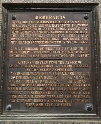
Massacre Monument Marker
RANKED BY RELEVANCE, THEN GEOGRAPHICALLY
| 101 ► Iowa, Dickinson County, Arnolds Park — Massacre Monument — Gardner Cabin — |
| On Monument Drive at Miriam Lane, on the right when traveling south on Monument Drive. | |||
| 102 ► Kansas, Bourbon County, Marmaton — Site of Marmaton Massacre — Oct. 22, 1864 — |
| On Kansas Road west of 155th Street, on the right when traveling west. | |||
| 103 ► Kansas, Cherokee County, Baxter Springs — 6 — Baxter Springs Massacre — Civil War Tour — |
| On Military Avenue (U.S. 69), on the right when traveling south. | |||
| 104 ► Kansas, Cherokee County, Baxter Springs — Baxter Springs Massacre — |
| On Park Avenue at 10th Street, on the left when traveling north on Park Avenue. | |||
| 105 ► Kansas, Cherokee County, Baxter Springs — 49 — Baxter Springs Massacre — |
| On U.S. 69/400, 0.2 miles south of SE Varck Road, on the right when traveling south. | |||
| 106 ► Kansas, Cherokee County, Baxter Springs — Baxter Springs Massacre 1863 — |
| On Military Avenue (U.S. 69). | |||
| 107 ► Kansas, Cherokee County, Baxter Springs — 9 — Baxter Springs Massacre Burial Site — Civil War Tour — |
| On 6th Street near Military Avenue (U.S. 69), on the left when traveling east. | |||
| 108 ► Kansas, Cherokee County, Riverton — Baxter Springs Massacre and Today — A battle spread across the Plains — |
| On U.S. 400 near State Highway 66, on the right when traveling south. | |||
| 109 ► Kansas, Linn County, Trading Post — 46 — Marais des Cygnes Massacre — |
| On U.S. 69 near Kansas Highway 52. | |||
| 110 ► Kansas, Linn County, Trading Post — Marais des Cygnes Massacre State Historic Site Trail — |
| 111 ► Kansas, Sherman County, Goodland — The Kidder Massacre — |
| On County Route 28 at 77, on the right when traveling north on County Route 28. | |||
| 112 ► Kentucky, Ballard County, Wickliffe — 1309 — Fort Jefferson Site / Indian Massacre — |
| On Westvaco Road (U.S. 51/62), on the right when traveling south. | |||
| 113 ► Kentucky, Bullitt County, Shepherdsville — 2580 — Brooks' Spring / Westerfield Massacre — |
| On West Hebron Lane, 0.1 miles south of John Harper Highway (Kentucky Route 1526), on the left when traveling south. | |||
| 114 ► Kentucky, Grant County, Crittenden — 936 — An Indian Massacre — |
| On Violet Rd (Kentucky Route 491), on the left when traveling west. | |||
| 115 ► Kentucky, Jefferson County, Louisville, Fisherville — 991 — Long Run Massacre — |
| On Shelbyville Road (U.S. 60) west of Arlington Meadows Drive, on the right when traveling west. | |||
| 116 ► Kentucky, Letcher County, Pound Gap — Pound Gap Massacre — |
| Near U.S. 23, on the right when traveling north. | |||
| 117 ► Kentucky, Menifee County, Wellington — 189 — Murder Branch Massacre — |
| On Old Beaver Road (Route 1274) at Big Woods Road, on the right when traveling west on Old Beaver Road. | |||
| 118 ► Kentucky, Shelby County, Simpsonville — 2283 — "Horrible Massacre" / African American Cemetery — |
| On Shelbyville Road (U.S. 60) at Webb Road, on the right when traveling east on Shelbyville Road. | |||
| 119 ► Maryland, Baltimore, Inner Harbor — The Katyń Massacre, 1940 — Victims of Stalinist Terror — 20,000 Polish military officers murdered by the Soviet Secret Police (NKVD) — |
| On President Street at Aliceanna Street, in the median on President Street. | |||
| 120 ► Massachusetts, Essex County, Georgetown — Goodrich Massacre — 1630 - 1930 — |
| On North Street, 0.2 miles north of Meadowview Road when traveling north. | |||
| 121 ► Massachusetts, Franklin County, Deerfield — Deerfield Massacre — |
| On Albany Rd at Old Main Street, on the left when traveling north on Albany Rd. | |||
| 122 ► Massachusetts, Middlesex County, Framingham — Site of Eames Massacre — |
| On Chatauqua Avenue when traveling north. | |||
| 123 ► Massachusetts, Suffolk County, Boston, Beacon Hill — Boston Massacre Monument — |
| On Tremont Street south of West Street, on the right when traveling south. | |||
| 124 ► Massachusetts, Suffolk County, Boston, D Street / West Broadway — 4 / 5 — Boston Massacre 1770 / The East India Company — |
| On Congress Street east of Dorchester Avenue, on the right when traveling west. | |||
| 125 ► Massachusetts, Suffolk County, Boston, Downtown — A Riot, the Massacre, and the Tea Party |
| On Tremont Street at Bromfield Street, on the left when traveling north on Tremont Street. Reported missing. | |||
| 126 ► Massachusetts, Suffolk County, Boston, Downtown — Victims of the Boston Massacre — |
| On Tremont Street, on the left when traveling north. | |||
| 127 ► Massachusetts, Suffolk County, Boston, Financial District — The Boston Massacre — |
| On Devonshire Street at State Street on Devonshire Street. | |||
| 128 ► Massachusetts, Worcester County, Oxford — The Johnson Massacre — |
| On Massachusetts Route 12, 0.1 miles Johnson Lane, on the right when traveling south. | |||
| 129 ► Michigan, Wayne County, Grosse Pointe Park — S0502 — Fox Indian Massacre — |
| On Windmill Pointe Drive at Lakepointe Street, on the left when traveling west on Windmill Pointe Drive. | |||
| 130 ► Minnesota, Jackson County, Jackson — Jackson County Massacre Monument — |
| On Riverside Drive, 0.1 miles west of State Street, on the left when traveling west. | |||
| 131 ► Minnesota, Jackson County, Jackson — Olson Slaabakken Cabin / The Jackson County Massacre Monument — |
| On Riverside Drive, 0.1 miles west of State Street, on the left when traveling west. | |||
| 132 ► Minnesota, Kandiyohi County, New London — The West Lake Massacre — |
| Near 3rd Avenue Southwest east of Oak Street South, on the right when traveling east. | |||
| 133 ► Minnesota, Lake of the Woods County, Baudette — Massacre Island — |
| Near International Drive (Highway 72) 0.2 miles north of 3rd Street Northeast, on the right when traveling north. | |||
| 134 ► Minnesota, McLeod County, Brownton — White Family Massacre — |
| On Division Street West (County Highway 32) east of State Highway 15, on the right when traveling west. | |||
| 135 ► Minnesota, Swift County, Sunburg — Broberg Cabin Massacre Site — |
| On Unnamed park road north of 15th Street NE (County Highway 95), on the right when traveling north. | |||
| 136 ► Minnesota, Wright County, Howard Lake — The Dustin Massacre — |
| On 60th Street SW (U.S. 12) 0.4 miles west of Keats Avenue SW, on the right when traveling west. | |||
| 137 ► Mississippi, Hinds County, Clinton — 32 — The Clinton Massacre — Mississippi Freedom Trail — |
| On West Northside Drive, 0.2 miles west of Vernon Road, on the left when traveling west. | |||
| 138 ► Missouri, Caldwell County, Braymer — Haun's Mill Massacre — |
| On NE Hauns Mill Drive, 0.5 miles west of Catawba Road, on the left when traveling west. | |||
| 139 ► Missouri, Jackson County, Kansas City, Downtown Kansas City — In Memory of Law Enforcement Officers Killed in the "Kansas City Massacre" — June 17, 1933 — |
| On West Pershing Road. | |||
| 140 ► Missouri, Lafayette County, Concordia — Massacre Site / Concordia — |
| On Main Street (Missouri Route 23) at SW 6th Street, on the right when traveling south on Main Street. | |||
| 141 ► Missouri, Marion County, Palmyra — Palmyra Massacre — A State Divided — The Civil War in Missouri — |
| On West Lafayette Street at South Dickerson Street, on the right when traveling west on West Lafayette Street. | |||
| 142 ► Missouri, St. Louis County, Lemay — Victims of the Japanese Massacre — Puerto Princesa, Palawan, P.I. [Philippine Islands] — December 14, 1944 — |
| On Circle Drive east of Bundy Drive, on the left when traveling east. | |||
| 143 ► Montana, Chouteau County, Loma — Victims of Blood Indian Massacre — |
| On U.S. 87 near Lower Marias/Loma Ferry Roads, on the left when traveling north. | |||
| 144 ► Montana, Toole County, Shelby — The Baker Massacre — |
| On U.S. 2 at milepost 283 near Kraft Road, on the left when traveling east. | |||
| 145 ► Nebraska, Hitchcock County, Trenton — 8 — Massacre Canyon — |
| On U.S. 34 near Old Highway 34, on the right when traveling east. | |||
| 146 ► Nebraska, Phelps County, Bertrand — Plum Creek Massacre Site — August 8, 1864 — |
| On Local Route 748. | |||
| 147 ► Nebraska, Phelps County, Bertrand — The Plum Creek Massacre — |
| On B Road (Local Route 748). | |||
| 148 ► Nevada, Eureka County, Eureka — Charcoal Burners Massacred Aug. 18, 1879 — |
| Near Caribou Way at Holly Road. | |||
| 149 ► New Hampshire, Strafford County, Durham — 050 — Oyster River Massacre — |
| On Newmarket Road (New Hampshire Route 108), on the right when traveling east. | |||
| 150 ► New Jersey, Bergen County, River Vale — “The Baylor Massacre” — September 28, 1778 — |
| On Red Oak Drive at Rivervale Road, on the right when traveling east on Red Oak Drive. | |||
| 151 ► New Jersey, Bergen County, River Vale — A Night of “Savage Cruelty” — September 28, 1778 — |
| On Red Oak Drive, on the right when traveling east. | |||
| 152 ► New Jersey, Bergen County, River Vale — Baylor Massacre Millstone — |
| On Red Oak Drive at Rivervale Road, on the right when traveling east on Red Oak Drive. | |||
| 153 ► New Jersey, Bergen County, River Vale — 47 — Baylor Massacre Park — |
| On Red Oak Drive at Rivervale Road, on the right when traveling east on Red Oak Drive. | |||
| 154 ► New Jersey, Bergen County, River Vale — The Baylor Massacre — |
| On Rivervale Road. | |||
| 155 ► New Jersey, Ocean County, Barnegat Light — Massacre at Long Beach — |
| Near Broadway, on the right when traveling north. | |||
| 156 ► New Jersey, Salem County, Hancocks Bridge — Hancock House Massacre — |
| On New Street at Locust Island Road, on the right when traveling south on New Street. | |||
| 157 ► New Jersey, Salem County, Hancocks Bridge — Patriots Massacred in the Hancock House — |
| On Front Street at Locust Island Road, on the left when traveling south on Front Street. | |||
| 158 ► New York, Greene County, Round Top — Massacre 1790 — |
| On South Road, 0.1 miles west of Kerwin Road, on the right when traveling east. | |||
| 159 ► New York, Niagara County, North Tonawanda — Massacre On Wake Island — |
| On River Road (New York State Route 384) north of Wheatfield Street, on the left when traveling north. | |||
| 160 ► New York, Otsego County, Cherry Valley — Cherry Valley Massacre — |
| On Alden Street. | |||
| 161 ► New York, Schenectady County, Schenectady — Commemorating Massacre — |
| On Front Street at North Church Street, on the right when traveling east on Front Street. | |||
| 162 ► New York, Ulster County, Ellenville — Fantinekill Massacre Memorial — In Memoriam — |
| On Main Street (U.S. 209) north of Aluminum Drive, on the right when traveling north. | |||
| 163 ► North Carolina, Guilford County, Greensboro — J-28 — Greensboro Massacre — |
| On McConnell Road at Dunbar Street, on the right when traveling west on McConnell Road. | |||
| 164 ► North Carolina, Madison County, Marshall — P-71 — "Shelton Laurel Massacre" — |
| On State Highway 208. | |||
| 165 ► Ohio, Coshocton County, Coshocton — Broadhead Massacre — |
| On Chestnut Street, on the right when traveling east. | |||
| 166 ► Ohio, Lucas County, Maumee — C27 — Dudley's Massacre — Ohio Revolutionary Memorial Trail — |
| On River Road, 0.1 miles north of East John Street, on the right when traveling south. | |||
| 167 ► Ohio, Mercer County, Fort Recovery — St. Clair Massacre — |
| On Fort Site Street just south of West Boundary Street, on the right when traveling south. | |||
| 168 ► Ohio, Miami County, Fletcher — The Dilbone Massacre — |
| On U.S. 36, on the right when traveling west. | |||
| 169 ► Ohio, Morgan County, Stockport — 11-58 — Big Bottom Massacre — |
| On Ohio Route 266, on the right when traveling south. | |||
| 170 ► Ohio, Tuscarawas County, Gnadenhutten — 15-79 — Gnadenhutten / The Gnadenhutten Massacre, "A Day of Shame" — |
| Near South Cherry Street, 0.2 miles south of West Indian Street. | |||
| 171 ► Ohio, Wood County, Luckey — A126 — to Whittaker's Reserve / to Dudley's Massacre — Ohio Revolutionary Memorial Trail — Harrison's March |
| On Fremont Pike (U.S. 20) at Bradner Road (County Route 16), on the right when traveling east on Fremont Pike. Reported missing. | |||
| 172 ► Ohio, Wood County, Perrysburg — A122 — to Dudley's Massacre / to Portage Stockade — Ohio Revolutionary Memorial Trail — Harrison-Hull-Tupper Marches |
| On Dixie Highway (Ohio Route 25) at Ovitt Road (County Route 104), on the left when traveling north on Dixie Highway. Reported missing. | |||
| 173 ► Oklahoma, Tulsa County, Tulsa — Lynching in America / The 1921 Tulsa Massacre — Community Remembrance Project — |
| On North Greenwood Avenue at East Cameron Street, on the right when traveling north on North Greenwood Avenue. | |||
| 174 ► Oregon, Baker County, Huntington — Van Ornum Massacre — |
| On Oregon Trail Boulevard (Business U.S. 30) near Frontage Road, on the left when traveling north. | |||
| 175 ► Oregon, Baker County, Huntington — Van Ornum Wagon Train Massacre — |
| On Oregon Trail Boulevard (Business U.S. 30) when traveling north. | |||
| 176 ► Oregon, Baker County, Huntington — Van Ornum Wagon Train Massacre — |
| On Washinton Street East (Business U.S. 30) near 1st Street East. | |||
| 177 ► Oregon, Wallowa County, Imnaha — Chinese Massacre Cove — |
| 178 ► Pennsylvania, Chester County, Malvern — Massacre Farm / 19th Century House — |
| On Un-named Loop Road, North off Monument Avenue, on the left when traveling north. | |||
| 179 ► Pennsylvania, Chester County, Malvern — Paoli Massacre Monument — |
| On Monument Avenue, on the left when traveling west. | |||
| 180 ► Pennsylvania, Chester County, Malvern — Site of Paoli Massacre — |
| On S. Warren Road at Paoli Pike, on the right when traveling north on S. Warren Road. | |||
| 181 ► Pennsylvania, Chester County, Malvern — Site of the Paoli Massacre — 20 September 1777 — |
| On Monument Avenue, on the left when traveling west. | |||
| 182 ► Pennsylvania, Greene County, Garards Fort — Corbly Massacre Monument — |
| Near Garards Fort Road (Pennsylvania Route 2011) west of Huggins Road, on the right when traveling west. | |||
| 183 ► Pennsylvania, Lancaster County, Lancaster — Site of Conestoga Indian Massacre — December 27, 1763 — |
| On North Water Street north of West King Street, on the right when traveling north. | |||
| 184 ► Pennsylvania, Luzerne County, Hazleton — Lattimer Massacre — |
| On Pennsylvania Route 924 at 2nd Street, on the right when traveling east on State Route 924. | |||
| 185 ► Pennsylvania, Luzerne County, Lattimer — Lattimer Massacre — September 10, 1897 — |
| On Lattimer Road (Pennsylvania Route 3028) at Quality Road on Lattimer Road. | |||
| 186 ► Pennsylvania, Luzerne County, Lattimer — Lattimer Massacre — |
| On Quality Road at Lattimer Road (Pennsylvania Route 3028) on Quality Road. | |||
| 187 ► Pennsylvania, Luzerne County, Sugarloaf — Sugarloaf Massacre — |
| On Pennsylvania Route 93 at Hidden Creek Court on State Route 93. | |||
| 188 ► Pennsylvania, Luzerne County, Sugarloaf — The Sugarloaf Massacre — |
| On Walnut Avenue at Orchard Lane on Walnut Avenue. | |||
| 189 ► Pennsylvania, Lycoming County, Williamsport — Site of Settler Massacre — |
| On Cemetery Street north of 4th Street, on the left when traveling north. | |||
| 190 ► Pennsylvania, Snyder County, Selinsgrove, Monroe Township — Penns Creek Massacre — |
| On North Market Street (U.S. 522) at Susquehanna Trail (U.S. 15), on the right when traveling south on North Market Street. | |||
| 191 ► Pennsylvania, Snyder County, Selinsgrove, Monroe Township — The (John) Penn's Creek Massacre — |
| On South Old Trail south of Airport Road when traveling south. | |||
| 192 ► Pennsylvania, Union County, Mifflinburg, Limestone Township — Leroy Massacre — |
| On Pennsylvania Route 104, 0.2 miles north of Red Ridge Road (County Route 3004), on the left when traveling north. | |||
| 193 ► Pennsylvania, Union County, Winfield, Union Township — Lee Massacre — |
| On Westbranch Highway (U.S. 15) at Pennsylvania Route 304, on the right when traveling north on Westbranch Highway. | |||
| 194 ► Pennsylvania, Westmoreland County, East Huntingdon — Morewood Massacre — |
| On Morewood Street (Pennsylvania Route 981) 0.2 miles west of U.S. 119, on the right when traveling east. | |||
| 195 ► Pennsylvania, Westmoreland County, Scottdale — Morewood Massacre — |
| Near Scottdale Dawson Road (Pennsylvania Route 819) at Hornertown Road, on the right when traveling south. | |||
| 196 ► Puerto Rico, Municipio de San Juan, San Juan, Puerta de Tierra — Masacre de Lod / Lod Massacre — 30 de mayo de 1972 / May 30, 1972 — |
| On Avenida de la Constitución (Puerto Rico Route 25) west of Calle Reverendo Gerardo Dávila, on the right when traveling east. | |||
| 197 ► South Carolina, Aiken County, North Augusta — 2 45 — The Hamburg Massacre — |
| On Barton Road at Boylan Street, on the right when traveling south on Barton Road. | |||
| 198 ► South Carolina, Greenville County, Greer — 23-33 — Early White Settlement / The Massacre of Jacob Hite — |
| On Gibbs Shoals Road (County Road 164) 0.1 miles north of East Suber Road (County Road 540), on the right when traveling south. | |||
| 199 ► South Carolina, Greenwood County, Greenwood — Lynching in America / The Phoenix Massacre — Community Remembrance Project — |
| Near North Hospital Street north of Brewer Avenue, on the right when traveling north. | |||
| 200 ► South Carolina, Greenwood County, Troy — 24-1 — Long Canes Massacre — |
| On Main Street West near Twigg Street (South Carolina Highway 10). | |||
984 entries matched your criteria. Entries 101 through 200 are listed above. ⊲ Previous 100 — Next 100 ⊳
* Inflectional forms of words are their plurals, singulars, and possessives as well as gramatical tenses and similar variations.