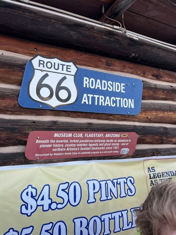
On East Route 66 (U.S. 180) west of Fanning Drive, on the right when traveling west.
Beneath the inverted, forked ponderosa entryway awaits an adventure in pioneer history, country-western legends and ghost stories - one of northern Arizona's liveliest landmarks since 1931.
Recognized by Hampton Hotels Save-A-Landmark . . . — — Map (db m192855) HM
On Interstate 40 Frontage Road west of Dennison T I, on the left when traveling west. Reported missing.
A Route 66 icon since the 1940's. Meteor City Trading Post is home to the "World's Longest Map of Route 66."
Recognized by Hampton Hotels Save-A-Landmark program as a site worth seeing — — Map (db m194738) HM
On West Andy Devine Avenue (Old U.S. 66) west of North 1st Street, on the left when traveling west.
The Powerhouse, Arizona's oldest known reinforced concrete industrial building, generated electricity from 1909 to 1938. After serving as a substation and later a recycling center, it was renovated to its current use and condition in 1997 by the . . . — — Map (db m193159) HM
On Oatman Highway (Old U.S. 66) at Rock Hound Hill Road on Oatman Highway.
This turn of the century gold mining camp was on the original road through the Black Mountains and eventually became Route 66. Burrows came with the miners and still roam the streets today.
Get you Kicks on Route 66 in Arizona. — — Map (db m188974) HM
On Hopi Drive at 7th Avenue, on the right when traveling east on Hopi Drive.
Dear Mr. Paul Lewis
It is my pleasure to inform you that the Wigwam Village #6 at 811 W. Hopi Dr. in Holbrook was listed on the National Register of Historic Places on May 2, 2002.
As you know, the National Register is the official listing . . . — — Map (db m119936) HM
Opened in 1949, tourists were drawn to stop and see what "here it is" was all about. Their marketing campaign placed mileage signs along the highway counting down the distance to the oversized jackrabbit. — — Map (db m192859) HM
On East 2nd Street (Business Interstate 40) east of Arizona Route 87, on the right when traveling east.
Mary Colter's masterpiece, La Posada was one of the last great railroad hotels and known as one of the fanciest on Route 66.
Recognized by Hampton Hotels Save-A-Landmark program as a site worth seeing — — Map (db m192857) HM
On North Kinsley Avenue at West 2nd Street (Business Interstate 40), on the right when traveling south on North Kinsley Avenue.
This area was dedicated on September 11, 1999 as a tribute to the memorable song of the 1970's that made Winslow, Arizona a town to sing about on famous Route 66. — — Map (db m36329) HM
On Grand Canyon Caverns Road, on the right when traveling west.
An Arizona natural wonder in continuous operation since 1927.
Recognized by Hampton Hotels Save-A-Landmark program as a site worth seeing — — Map (db m194739) HM
On West Old Highway 66 (Old U.S. 66) at Lamport Street, on the right when traveling east on West Old Highway 66.
Juan Delgadillo built the now famous Snow Cap in Seligman, Arizona in 1953 out of scrap lumber. Home of the "Cheeseburger with cheese" and "Dead Chicken".
Get your Kicks on Route 66 in Arizona, learn more at www.historicaz66.com . . . — — Map (db m201770) HM
On National Trails Highway east of Old Amboy Road, on the right when traveling west.
Founded in 1858, Amboy provided a vital rest stop for weary sun drenched travelers seeking a better life in California.
Amboy owned and operated by Juan Pollo restaurants. — — Map (db m193157) HM
On North 1st Avenue west of Lawrence Dale Drive, on the left when traveling south.
One of the finest surviving examples of California's depot-hotels built around the turn of the 19th century. It's also home to the Route 66 "Mother Road" Museum and the Western American Railroad Museum (W.A.R.M.).
Recognized by Hampton . . . — — Map (db m193156) HM
On Lanfair Road 0.1 miles north of Goffs Road (County Route 66), on the left when traveling north.
The Goffs Schoolhouse served this highway, railway, ranching and mining community from 1914 to 1937. It was restored in 1998 and is now listed on the National Historic Register.
Recognized by Hampton Hotels Save-A-Landmark program as a . . . — — Map (db m194736) HM
On Quinn Court at G Street, on the right when traveling west on Quinn Court.
Formerly one of the grandest Harvey House Hotel, Restaurant & Santa Fe Train Stations. The hotel and restaurant were open from 1908 to 1949. The train station closed in 1988.
Recognized by Hampton Hotels Save-A-Landmark program as a site . . . — — Map (db m33445) HM
On National Trails Highway 2 miles west of Fort Cady Road, on the right when traveling west.
Originally built in the 1950s, this world-famous restaurant was the location of the 1988 film, "Bagdad Café," which became the new name of the restaurant in 1995. — — Map (db m160081) HM
On Foothill Boulevard 0.1 miles east of Grove Avenue, on the right when traveling east.
The Magic Lamp Inn has been a dining tradition on Route 66 since 1955.
Recognized by Hampton Hotels Save-A-Landmark program as a site worth seeing. — — Map (db m158338) HM
On North E Street near West 14th Street, on the right when traveling south.
McDonalds hamburgers and fries represent a true slice of Americana. This site is ground zero for all modern day fast food chains.
Museum owned and operated by Juan Pollo restaurants — — Map (db m204525) HM
On North Mount Vernon Avenue (Old U.S. 66), on the right when traveling north. Reported missing.
Built in 1945, this park continues to provide a center reminiscent of early Mexican Heritage.
Recognized by Hampton Hotels Save-A-Landmark program as a site worth seeing. — — Map (db m204524) HM
On North Mount Vernon Avenue (Old U.S. 66) north of West 6th Street, on the right when traveling south.
Established in 1937, this family-owned restaurant has brought history and tradition to San Bernardino's west side for more than 60 years.
Recognized by Hampton Hotels Save-A-Landmark program as a site worth seeing — — Map (db m204523) HM
On D Street (Business Interstate 15) east of 5th Street, on the right when traveling east.
Built in the late 1930s as "Red Rooster," later "Les Pyrenees Restaurant." Museum dedicated to those who lived, passed through and passed on here.
Recognized by Hampton Hotels Save-A-Landmark program as a site worth seeing — — Map (db m193155) HM
On North Frontage Road south of S Quincy Road, on the right when traveling east.
The Chicken Basket was established in 1946 born out of a gas station next door that sold fried chicken. It was a Blue Bird bus stop as well as a restaurant and used to have ice skaters on the roof to attract Route 66 travelers. It became Dell . . . — — Map (db m312061) HM
This nostalgic barn has been restored by volunteers of the Route 66 Association of Illinois Preservation Committee. August 30, 1998 — — Map (db m157025) HM
On West Waupansie Street (Old U.S. 66) at West Mazon Street (Illinois Route 17), on the right when traveling north on West Waupansie Street. Reported permanently removed.
Built in 1933, Ambler's Texaco was the longest operating service station to pump gas on historic Route 66.
Recognized by Hampton Hotels Save-A-Landmark program as a site worth seeing — — Map (db m189147) HM
On S West Street at West Deer Street on S West Street.
This restoration is a project of the Route 66 Association of Illinois Preservation Committee. Identified November 9, 1997 on the National Register of Historic Places. — — Map (db m157019) HM
On North Division Street north of West Jefferson Street.
The original bridge was built in 1926 as part of Route 4. On November 11, 1926, the alignment of Route 4 through Pontiac became US Route 66. In early days, the highways were marked with paint using a stencil on utility poles and on bridge end . . . — — Map (db m157015) HM
Route 66 has become a nostalgic symbol of Americana. This display honors just one of the many mom & pop businesses that served weary travelers on the Mother Road. At it's original location, many thousands of people from around the world stopped to . . . — — Map (db m163373) HM
On 5th Street (Business Interstate 55) at South Monroe Street, on the right when traveling west on 5th Street.
Abraham Lincoln practiced law here from 1840-1847. This site is located on the original alignment of Route 66 through Lincoln, Illinois. Free admission. — — Map (db m156851) HM
On South Washington Street at 1st Street, on the right when traveling north on South Washington Street.
The Mill opened in 1929 on the original alignment of Route 66, it became famous as a sandwich stand and then a Bar/Restaurant. The Mill is now being restored as a museum. Open by appointment. — — Map (db m156855) HM
On West 1st Street (Old U.S. 66) at Old U.S. 66, on the left when traveling west on West 1st Street. Reported missing.
Russell Soulsby built this station in 1926 with his father, Henry
He ran it with his sister Ola until 1991. For its 65 years of operation; they only sold Shell gasoline. — — Map (db m138433) HM
On Parade Road south of Old U.S. 66, on the left when traveling south.
This original section of Historic Route 66 was dedicated in 1926. The alignment was first known as Route 4. Memory Lane is open to drive on during Lexington's annual Route 66 reunion, car show/parade and other special Route 66 events.
We . . . — — Map (db m163090) HM
You are standing on the pavement of the original Route 66 that was commissioned in 1926. The width of the original hard road was only 16' wide and constructed from Portland cement. The road immediately in front of you is the upgraded Route 66 known . . . — — Map (db m157604) HM
On Old U.S. 66 south of North Jefferson Street, on the right when traveling south.
The Towanda, Il. Route 66 Parkway stretches 1 mile in front of you and 2.5 miles behind you. You are standing on the 1954 alignment of Route 66. The original 1926 two lane Route 66 is behind you and to the right and just up this road and to the . . . — — Map (db m157605) HM
On Old Rte 66 N, on the right when traveling south.
Satisfying local patrons and international travelers since 1924, this landmark stop continues to attract diners who "remember where good food is served"
Route 66 Roadside Attraction Recognized by Hampton Hotels Save-A-Landmark program as . . . — — Map (db m138435) HM
On West Frontage Road north of North 22nd Avenue (Illinois Route 48), on the left when traveling north.
Even though it was wonderful to have a paved, hard road to travel on, many motor vehicle accidents did occur on Route 66.
In 1959, this shrine was erected to remind motorists of the potential dangers and offered a place to say a prayer for a . . . — — Map (db m156780) HM
On North Peoria Road (Business Interstate 55) south of Percy Avenue, on the right when traveling east. Reported permanently removed.
Family-owned and operated, Shea's has been under the same management since 1946.
Recognized by Hampton Hotels Save-A-Landmark program as a site worth seeing — — Map (db m189148) HM
On North Broadway Street (Illinois Route 53) north of Moran Street, on the left when traveling south.
Stop by to grab an ice cream treat and stroll through the park for many great photo opportunities. The Rich and Creamy Ice Cream stand is the highlight of Route 66 Park, having served travelers for years. Be sure to look up and see Jake & Elwood . . . — — Map (db m157508) HM
On North Ottawa Street (Illinois Route 53) near Webster Street, on the right when traveling south.
A clearinghouse for information as you travel down the Mother Road, the Route 66 Experience has information on Route 66, Lincoln Highway and all of Joliet! Visit the Free Route 66 Experience with interactive features to entertain for hours! A key . . . — — Map (db m157506) HM
On Military Avenue (U.S. 69) at 11th Street, on the right when traveling south on Military Avenue.
Built circa 1870, the café was formerly the Crowell Bank, which Jesse James robbed in 1876. It is currently a restaurant and bed and breakfast. — — Map (db m37551) HM
On Main Street (Historic US Route 66) near 5th Street, on the right when traveling south.
In 2001, members of the community joined with the Galena Chamber of Commerce to donate a block of the downown Route 66 main street to construct a park for everyone to enjoy.
Route 66 Howard "Pappy" Litch Park
The Oldest Mining Town in . . . — — Map (db m43047) HM
On South Main Street at West 6th Street, on the right when traveling south on South Main Street.
Built in 1939 out of native stone, this filling station served
travelers for decades under the ownership of Logan Thompson.
It closed shortly after 2000, but renovations by Aaron
Perry started in 2018, reopening as Gearhead Curios in 2019. — — Map (db m272259) HM
On South Main Street (U.S. 66) south of East 5th Street, on the right when traveling south.
In 2001, members of the community joined with the Galena Chamber of Commerce to donate a block of the downtown Route 66 main street to construct a park for everyone to enjoy. — — Map (db m272254) HM
On East Osage Street (Old U.S. 66) east of North Elm Street, on the right when traveling west.
This World War II era Quonset hut, with a unique stone façade was built here in 1950. It started out as a family-run dry cleaning business by the original owners. Over the years it has been a photo studio and the home of several roadside diners . . . — — Map (db m205178) HM
On South National Avenue at East St. Louis Street, on the right when traveling south on South National Avenue.
One of the few remaining "old style" designs for this chain of drive-in restaurants, opened in 1962. It still features curb service, steak burgers and hand-dipped milkshakes. — — Map (db m170629) HM
Near West College Street (Old U.S. 66) west of Park Avenue.
This Ozark sandstone tourist court was built in 1929 by Deverne Ruckman. The original six tourist cabins and Shell filling station operated under various names until 1948, when it became the Rockwood Motor Court. It was renovated in 2019. . . . — — Map (db m274387) HM
On West Main Street (Old U.S. 66) east of Washington Street, on the left when traveling west.
Supertam on 66, known for their collection of over 2500 items celebrating the Man of Steel, was opened in 2006 by Larry Tamminen. When he retired in 2021, the Briley family took over the ice cream shop and continues its all-American tradition. . . . — — Map (db m311744) HM
On Old U.S. 66 west of County Highway 170, on the right when traveling west. Reported missing.
Built in 1949, the last of the original six drive-ins that were named after the famous "Mother Road'.
Recognized by Hampton Hotels Save-A-Landmark program as a site worth seeing — — Map (db m189152) HM
On South Garrison Avenue (U.S. 66) at West Central Avenue (Missouri Route 96), on the right when traveling south on South Garrison Avenue.
Arthur Boots built this Streamline Moderne style motor court in 1939,
featuring a “Radio in Every Room,” at the intersection of Route 66
and the Jefferson Highway, known as the “Crossroads of America.”
The motel was expanded in 1946 and restored . . . — — Map (db m251588) HM
On County Loop 122 0.1 miles south of Kafir Road, on the right when traveling south.
In 1987, Lowell Davis began collecting buildings from ghost towns
and other historic sites to create his own community near Carthage.
This inhabited village features many of Lowell's unique creations
and continues as a tribute to the “Norman . . . — — Map (db m251593) HM
On South Main Street (Missouri Route D) south of East Church Street, on the right when traveling south.
Opened on March 1, 1946, Webb City's historic movie theater has served as a community gathering place and entertainment venue for generations. Its proximity to the Mother Road inspired owners Scott and Nancy Hutson to rename it after Route 66 in . . . — — Map (db m311991) HM
On Old U.S. 66 east of Lawrence (Route 1210), on the right when traveling west.
Formerly known as Gay Parita Sinclair Service, Fred and Gay Mason established a station here in 1930. It was lovingly recreated by Gary & Lena Turner in 2006. The Turners became known around the world for their hospitality and passion for Route 66. . . . — — Map (db m273125) HM
On Lawrence 2062 0.1 miles west of Highway N, on the right when traveling west.
In 1925, Sidney Casey walked 55 miles to purchase the ‘town’ of Spencer for $500. From 1926 until 1928, he constructed the general store, service station, café, and barber shop. Spencer was bypassed in 1961, saved in 2007, and a full restoration . . . — — Map (db m272081) HM
On Teardrop Road east of Tealhouse Drive, on the right when traveling east.
Established in 1870 and named after a bad bend in the Big Piney River, this "devil of an elbow" was made famous by historic Route 66. — — Map (db m170623) HM
On Chouteau Avenue (Missouri Route 100), on the left when traveling west.
Established in the 1940s, the Eat Rite-Diner is one of the few nostalgic Route 66 diners left for great burgers and a friendly atmosphere. — — Map (db m139770) HM
On Chippewa Street (State Highway 366) 0.2 miles east of Prather Avenue, on the right when traveling east.
Ted Drewes Frozen Custard has been located on Route 66 since 1941 and has been a St. Louis landmark since 1929. Many travelers have stopped to enjoy the world-famous "Concretes."
Recognized by Hampton Hotels Save-A-Landmark program as a . . . — — Map (db m147690) HM
On East Osage Street (Old U.S. 66) east of East Walnut Street, on the right when traveling west.
Opening in 1946 to all travelers of Route 66, the Beacon Court Motel is only a memory, but its iconic sign now lives on at its new home, the Beacon Car & Pet Wash. The Beacon tower was dormant from 1980 to 2004 but a full restoration was completed . . . — — Map (db m168407) HM
On East Osage Street (Old U.S. 66), on the right when traveling west.
Built in 1939 by the Civilian Conservation Corps (CCC), Jensen Point was part of the Henry Shaw Gardenway as a beautification project of the National Park Service and the Missouri State Highway Commission. The overlook was dedicated to Lars Peter . . . — — Map (db m205175) HM
On East Osage Street east of Clear Creek Road, on the right when traveling west. Reported permanently removed.
The restaurant was built in 1934 by brothers James and Bill Smith and is still owned and operated by the James Smith family.
Recognized by Hampton Hotels Save-A-Landmark program as a site worth seeing — — Map (db m189150) HM
On East Osage Street (Old U.S. 66), on the right when traveling west.
The restaurant was built in 1934 by brothers James and Bill Smith using logs from the family farm. It was owned and operated by the Smith family until closing in 2005. In 2023, the Red Cedar reopened as a museum and visitors' center. . . . — — Map (db m297422) HM
On Business Interstate 40 west of Greig Avenue, on the right when traveling west. Reported permanently removed.
Originally La Fiesta Café, Joseph's was opened in 1956. It has fed locals and tourists along Route 66 through three generations of Campos.
Recognized by Hampton Hotels Save-a-Landmark program as a site worth seeing — — Map (db m189205) HM
On West 3rd Street (Business Interstate 40) west of Pioneer Road, on the right when traveling west.
Established in 1998, the National Route 66 and Old Town Museum Complex preserves the history of Route 66 in Western Oklahoma.
Recognized by Hampton Hotels Save-A-Landmark program as a site worth seeing — — Map (db m183510) HM
On South Sheb Wooley Street south of West 3rd Street, on the right when traveling south.
Formerly the City Meat Market, this is known as the oldest brick building in Erick. It is now the home of Harley and Annabelle, "The Mediocre Music Makers."
Recognized by Hampton Hotels Save-A-Landmark program as a site worth . . . — — Map (db m183509) HM
Near U.S. 60 west of South 4380 Road, on the right when traveling west.
Rebuilt by Tom Schwartz after the road was widened in 1963, and
purchased by the Wood and Hilburn families in 2011. Since then,
they were awarded the Guinness World Record for Most Stickers on
a Car, restored the neon sign, and installed Big Bill . . . — — Map (db m272317) HM
On U.S. 60 west of South 4380 Road, on the right when traveling west.
Henry and Emelia Wrage opened the Quarterhorse Motel in the 1950s. In addition to regular rooms, it featured stables for horses. It became the Western in the 1970s. Today the site is also home to a giant fiberglass chief that originally stood at a . . . — — Map (db m272309) HM
On Manvel Avenue (State Highway 66) at East 7th Street, on the right when traveling south on Manvel Avenue.
The Chandler Phillips 66 station is typical of the type "B" cottage-style built by Philips Petroleum 1927 through 1938.
Recognized by Hampton Hotels Save-a-Landmark program as a site worth seeing — — Map (db m189193) HM
On Northwest 39th Street (State Highway 66) west of North Tulsa Avenue, on the right when traveling east. Reported permanently removed.
Built in 1948 as a gas station, this site was converted into a restaurant in 1966 and became Ann's Chicken Fry House in 1971. It is famous for its chicken-fried steak.
Recognized by Hampton Hotels Save-a-Landmark program as a site worth . . . — — Map (db m189195) HM
On North Main Street (Old U.S. 66) north of 1st Avenue NW, on the right when traveling south. Reported missing.
Built by George L. Coleman, Sr. in 1929 at a cost of $500,000. The theatre is home to "The Mighty Wurlitzer," the original pipe organ.
Recognized by Hampton Hotels Save-A-Landmark program as a site worth seeing — — Map (db m189153) HM
On South Cherokee Street, on the right when traveling west. Reported permanently removed.
Original location of the Catoosa D-X filling station, Mojo's Famous BBQ opened in 1997.
Recognized by Hampton Hotels Save-a-Landmark program as a site worth seeing — — Map (db m189190) HM
On East Easton Street, on the right when traveling west.
"The Admiral Twin Drive-In, built in 1951, is one of a few drive-in theaters remaining in Oklahoma. Located on Route 66, it is Oklahoma's largest drive-in with a capacity of more than 1,000 cars."
Recognized by Hampton Hotels . . . — — Map (db m170404) HM
On East 11th Street (U.S. 66) at South Quincy Avenue, on the right when traveling west on East 11th Street.
This 1950s PEMCO gas station became the landing place of Buck
Atom in May 2019. The 21-foot-tall Muffler Man was custom made
and serves as an ambassador for the revitalization of Route 66
in Oklahoma … and beyond! — — Map (db m272364) HM
On North Main Street north of Railroad Street (Business Interstate 40), on the right when traveling south.
The Avalon Theater, built in the early 1930s, served the area of McLean for more than 50 years and is maintained by the Texas Route 66 Association.
Recognized by Hampton Hotels Save-a-Landmark program as a site worth seeing — — Map (db m189285) HM
On Kingsley Street south of First Street (Business Interstate 40), on the right when traveling south.
This Route 66 landmark now houses the Texas Route 66 Museum and the largest barbwire museum in the world.
Recognized by Hampton Hotels Save-A-Landmark program as a site worth seeing — — Map (db m183508) HM
On First Street (Business Interstate 40) at Gray Street, on the left when traveling west on First Street. Reported missing.
Built in the 1920s as the first Phillips 66 Station in Texas, operating for more than 50 years.
Recognized by Hampton Hotels Save-a-Landmark program as a site worth seeing — — Map (db m189286) HM
On West Historic Route 66 (Old U.S. 66) east of Business Interstate 40, on the right when traveling east.
Located at the exact geo-mathematical center of Route 66, the café is one of the oldest eateries on the highway.
Recognized by Hampton Hotels Save-A-Landmark program as a site worth seeing — — Map (db m183503) HM
On North 12th Street at West Main Street (Old U.S. 66), on the right when traveling south on North 12th Street.
A collection dedicated to the Mother Road, the museum houses items from Vega Zero Lockers. Established in 1944 at the "crossroads of the nation" on Route 66.
Recognized by Hampton Hotels Save-A-Landmark program as a site worth . . . — — Map (db m183506) HM
On South Main Street (U.S. 385) at Coke Street, on the right when traveling north on South Main Street.
Built in 1915 when the county seat was moved from Old Tascosa. Route 66 originally ran in front of the courthouse, turning west at its northwest corner.
Recognized by Hampton Hotels Save-A-Landmark program as a site worth . . . — — Map (db m183505) HM
On Southwest 6th Avenue (State Highway 279) just west of South Tennessee Street, on the left when traveling west.
This 1921 home in the San Jacinto Heights neighborhood was opened as an antique store in 1997 by Florence Mildred Carroll. It is named for Ivy Marie Meroney (1976-1996) and was restored after a 2022 fire thanks to the support of roadies from around . . . — — Map (db m286282) HM
On East Interstate 40 east of Big Texan Road, on the right when traveling west.
Home of the "Free 72 oz Steak," this famous Steak Ranch has been feeding hungry travelers since 1960. Young man, we fed your father!
Recognized by Hampton Hotels Save-A-Landmark program as a site worth seeing — — Map (db m183507) HM