302 entries match your criteria. The first 100 are listed. ⊳
Former U.S. Presidents: #32 Franklin D. Roosevelt Historical Markers
By Darren Jefferson Clay, July 10, 2022
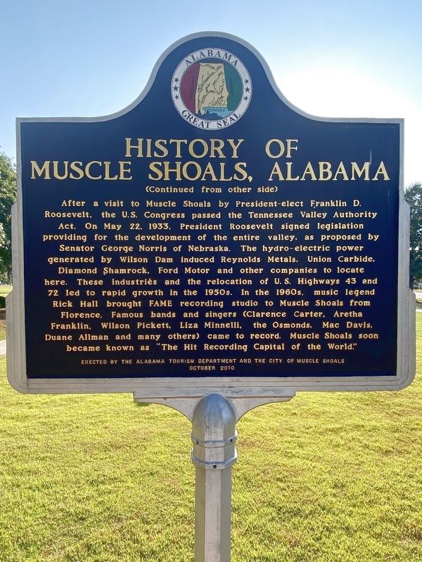
History of Muscle Shoals, Alabama Marker
| 1 ► Alabama, Colbert County, Muscle Shoals — History of Muscle Shoals, Alabama — |
| On Avalon Avenue. | |||
| 2 ► Alabama, Colbert County, Sheffield — President Franklin Delano Roosevelt — |
| On South Montgomery Avenue at West 1st Street, on the right when traveling south on South Montgomery Avenue. | |||
| 3 ► Alabama, Jefferson County, Trussville — Cahaba Project — "Slagheap Village" — A government project under President Franklin D. Roosevelt — |
| On Main Street (U. S. Highway 11) at Parkway Drive, on the left when traveling east on Main Street (U. S. Highway 11). | |||
| 4 ► Alabama, Lauderdale County, Florence — Edward Asbury O'Neal, III — City of Florence Walk of Honor — |
| Near Hightower Place south of Veterans Drive (Alabama Route 133), on the left when traveling south. | |||
| 5 ► Alabama, Lee County, Auburn — Auburn 1865~Present / The "Loveliest Village" — |
| On East Magnolia Avenue, 0.1 miles east of North College Street (Alabama Route 15), on the right when traveling west. | |||
| 6 ► Alabama, Lee County, Opelika — Bean's Mill — |
| On West Point Parkway (U.S. 29 at milepost 197), 0.6 miles south of County Road 390, on the right when traveling south. | |||
| 7 ► Alabama, Madison County, Huntsville — Civilian Conservation Corps — (C. C. C.) Camp — 1935~1940 — |
| On Monte Sano Blvd Southeast at Highland Plaza Southeast, on the right when traveling north on Monte Sano Blvd Southeast. | |||
| 8 ► Alabama, Montgomery County, Maxwell Air Force Base — British and Commonwealth Pilots Trained in the U.S.A. — |
| On Twining Street north of Ash Street, on the right when traveling north. | |||
| 9 ► Alabama, Morgan County, Decatur — Beauty and Hope — Restoring the Vision...Preserving The Legacy — |
| On Prospect Drive at 7th Street, on the right when traveling west on Prospect Drive. | |||
| 10 ► Alabama, Morgan County, Decatur — Our History — U.S. Fish and Wildlife Service — Wheeler National Wildlife Refuge — |
| On Wheeler Wildlife Boat Launch north of Alabama Route 67, on the right when traveling north. | |||
| 11 ► Alabama, Shelby County, Montevallo — The President's Oval Office / The Glorious Burden — |
| Near Montevallo Road (Alabama Route 119) 0.3 miles south of Alex Mill Road, on the right when traveling south. | |||
| 12 ► Alabama, Walker County, Jasper — First United Methodist Church Jasper / President Franklin Delano Roosevelt — Attends Funeral of William Brockman Bankhead — Speaker of the U.S. House of Representatives — |
| On Third Avenue. | |||
| 13 ► Alabama, Walker County, Jasper — William Brockman Bankhead Home — 1874-1940 — Speaker of the United States House of Representatives — |
| On Seventh Street. | |||
| 14 ► Arkansas, Searcy County, Marshall — Elton Britt — |
| On Elton Britt Avenue just west of Center Street (State Highway 27), on the left when traveling west. | |||
| 15 ► California, Alameda County, Oakland, Produce and Waterfront — USS Potomac — |
| Near Clay Street at Water Street. | |||
| 16 ► California, Contra Costa County, Richmond — Rosie the Riveter Memorial — Honoring American Women's Labor During WWII — |
| On Esplanade Drive near Melville Square. | |||
| 17 ► California, Marin County, Mill Valley — United Nations Conference on International Organization — |
| Near Main Trail. | |||
| 18 ► California, San Francisco City and County, San Francisco, Lincoln Park — FDR's Salute — to the Officers and Men ... USS "San Francisco"' — USS San Francisco Memorial — |
| Near El Camino Del Mar north of Sea Rock Drive. | |||
| 19 ► California, San Francisco City and County, San Francisco, Presidio of San Francisco — Western Defense Command Headquarters — |
| On Lincoln Boulevard at Keyes Street, on the right when traveling west on Lincoln Boulevard. | |||
| 20 ► California, Santa Barbara County, Goleta — 3 — Japanese Attack — |
| Near Hollister Avenue, 0.6 miles west of Cathedral Oaks Road, on the left when traveling west. | |||
| 21 ► California, Shasta County, Burney — The Civilian Conservation Corps: A Surviving Legacy — |
| Near Lake Road north of California Highway 89 S, on the right. | |||
| 22 ► California, Stanislaus County, Turlock — 934 — Turlock Assembly Center — Learning From the Past — |
| Near Broadway, 0.1 miles north of Canal Drive, on the left when traveling north. | |||
| 23 ► Colorado, Garfield County, Glenwood Springs — CCC Men Built Improvements for Glenwood — |
| On 8th Street east of Grand Avenue, on the right when traveling east. | |||
| 24 ► Colorado, Jefferson County, Golden — Brewing on Clear Creek-Coors History — |
| On Washington Avenue. | |||
| 25 ► Connecticut, Fairfield County, Stamford, Downtown — Freedom Shrine — |
| On Atlantic Street at Main Street, on the right when traveling north on Atlantic Street. | |||
| 26 ► Connecticut, Litchfield County, Barkhamsted, Riverton — Camp White — |
| On Legion Road, 0.1 miles south of West River Road, on the right when traveling south. | |||
| 27 ► Connecticut, Litchfield County, Kent, Cornwall Bridge — Camp Macedonia Company 1191 — |
| On Kent Cornwall Road (U.S. 7) 0.4 miles north of Carter Road, on the right when traveling north. | |||
| 28 ► Connecticut, Litchfield County, Torrington — To Honor The Men Of Camp Wolcott — |
| Near Burr Mountain Road, 0.2 miles north of Winsted Road, on the right when traveling south. | |||
| 29 ► Delaware, New Castle County, Wilmington, Swedes Landing — Fort Christina Monument — |
| Near East 7th Street just east of Swedes Landing Road, on the right when traveling east. | |||
| 30 ► District of Columbia, Washington, Northwest Washington, American University Park — 11 — Harry Country — Top of the Town — Tenleytown Heritage Trail — |
| On Chesapeake Street Northwest at River Road Northwest, on the right when traveling west on Chesapeake Street Northwest. | |||
| 31 ► District of Columbia, Washington, Northwest Washington, Downtown — Executive Office Building — |
| On Pennsylvania Avenue Northwest at 17th Street Northwest, on the right when traveling east on Pennsylvania Avenue Northwest. | |||
| 32 ► District of Columbia, Washington, Northwest Washington, Downtown — Jamila El Sahili — Human Being |
| On K Street Northwest (U.S. 29) just west of 12th Street Northwest, on the right when traveling west. Reported permanently removed. | |||
| 33 ► District of Columbia, Washington, Northwest Washington, Downtown — White House Kitchen Garden — National Park Service, U.S. Department of the Interior — |
| On E Street Northwest west of 15th Street Northwest, on the right when traveling west. | |||
| 34 ► District of Columbia, Washington, Northwest Washington, Federal Triangle — 14 — Equal Justice Under the Law — Make No Little Plans — Federal Triangle Heritage Trail — |
| On Constitution Avenue Northwest (U.S. 1/50) at 10th Street Northwest, on the right when traveling west on Constitution Avenue Northwest. | |||
| 35 ► District of Columbia, Washington, Northwest Washington, Federal Triangle — In Memory of Franklin Delano Roosevelt — 1882 - 1945 — |
| On Pennsylvania Avenue Northwest at 9th Street Northwest, on the right when traveling east on Pennsylvania Avenue Northwest. | |||
| 36 ► District of Columbia, Washington, Northwest Washington, Georgetown — Stephen Osusky — 1889 - 1973 — Paulina Osusky, 1892 - 1979 — |
| Near R Street Northwest just east of 30th Street Northwest, on the left when traveling east. | |||
| 37 ► District of Columbia, Washington, Northwest Washington, LeDroit Park — 4 — Government Girls — Worthy Ambition — LeDroit Park/Bloomingdale Heritage Trail — |
| On 3rd Street Northwest at U Street Northwest, on the left when traveling north on 3rd Street Northwest. | |||
| 38 ► District of Columbia, Washington, Northwest Washington, Logan Circle — Bethune Museum-Archives — National Historic Site — Designated October 15, 1982 by Act of Congress — |
| On Vermont Avenue Northwest at O Street Northwest, on the right when traveling south on Vermont Avenue Northwest. | |||
| 39 ► District of Columbia, Washington, Northwest Washington, Logan Circle — 11 — Striving for Equality — A Fitting Tribute — Logan Circle Heritage Trail — |
| On Vermont Avenue Northwest south of O Street Northwest when traveling north. | |||
| 40 ► District of Columbia, Washington, Northwest Washington, Mount Pleasant — 2 — Upheaval and Activism — Village in the City — Mount Pleasant Heritage Trail — |
| On 16th Street Northwest north of Irving Street Northwest, on the left when traveling north. | |||
| 41 ► District of Columbia, Washington, Northwest Washington, Rock Creek Park — Jusserand — Banc Commeratif Erige a la Memoir de Jean Jule Jusserand Ambassadeur de France — |
| On Western Ridge Trail, on the right when traveling west. | |||
| 42 ► District of Columbia, Washington, Northwest Washington, Woodley Park — Woodley Estate — |
| On Cathedral Avenue Northwest east of Woodley Road Northwest, on the right when traveling west. | |||
| 43 ► District of Columbia, Washington, Southeast Washington, Navy Yard — Presidential Fans / Fans! / Congressional Baseball Game — Baseball Americana — |
| Near South Capitol Street Southeast at Potomac Avenue Southeast, on the right when traveling north. | |||
| 44 ► District of Columbia, Washington, Southeast Washington, Navy Yard — Serving as the City's Diplomatic Gateway — Diplomacy — Behind These Walls — |
| On M Street Southeast east of 7th Street Southeast, on the right when traveling east. | |||
| 45 ► District of Columbia, Washington, Southwest Washington, Southwest Federal Center — The Benefits of Social Security — 1941 — granite — |
| On 3rd Street Southwest just south of Independence Avenue Southwest, on the right when traveling south. | |||
| 46 ► District of Columbia, Washington, Southwest Washington, Southwest Federal Center — Unemployment Compensation — 1940 — granite — |
| On 4th Street Southwest south of Independence Avenue Southwest, on the right when traveling north. | |||
| 47 ► District of Columbia, Washington, Southwest Washington, Southwest Federal Center — James Wilson — |
| On Independence Avenue Southwest near 14th Street Southwest, on the left when traveling west. | |||
| 48 ► District of Columbia, Washington, Southwest Washington, The National Mall — USDA Holocaust Memorial Tree — |
| On Jefferson Drive Southwest at 12th Street Northwest, on the right when traveling east on Jefferson Drive Southwest. | |||
| 49 ► District of Columbia, Washington, Southwest Washington, The National Mall — World War II Memorial — |
| On 17th Street Southwest north of Independence Avenue Southwest, on the left when traveling north. | |||
| 50 ► District of Columbia, Washington, Southwest Washington, The Tidal Basin — Thomas Jefferson Memorial — National Historic Landmark — |
| Near 14th Street Southwest west of Ohio Drive Southwest, on the right when traveling west. | |||
| 51 ► District of Columbia, Washington, Southwest Washington, West Potomac Park — "He Died in Harness" — 1945 / Fourth Term — Franklin Delano Roosevelt Memorial — |
| Near Ohio Drive Southwest south of West Basin Drive Southwest, on the right when traveling north. | |||
| 52 ► District of Columbia, Washington, Southwest Washington, West Potomac Park — A Carefully Crafted Image — Prologue — Franklin Delano Roosevelt Memorial — |
| On Ohio Drive Southwest south of West Basin Drive Southwest, on the right when traveling north. | |||
| 53 ► District of Columbia, Washington, Southwest Washington, West Potomac Park — Combatting Economic Depression — 1937-1941 / Second Term — Franklin Delano Roosevelt Memorial — |
| On Ohio Drive Southwest south of West Basin Drive Southwest, on the right when traveling north. | |||
| 54 ► District of Columbia, Washington, Southwest Washington, West Potomac Park — Franklin Delano Roosevelt Memorial — President of the United States of America — 1933 - 1945 — |
| On West Basin Drive Southwest east of Ohio Drive Southwest, on the left when traveling west. | |||
| 55 ► District of Columbia, Washington, Southwest Washington, West Potomac Park — I Hate War — 1941-1945 / Third Term — Franklin Delano Roosevelt Memorial — |
| Near Ohio Drive Southwest south of West Basin Drive Southwest, on the right when traveling north. | |||
| 56 ► District of Columbia, Washington, Southwest Washington, West Potomac Park — Nothing to Fear… — 1933-1937 / First Term — Franklin Delano Roosevelt Memorial — |
| Near Ohio Drive Southwest south of West Basin Drive Southwest, on the right when traveling north. | |||
| 57 ► District of Columbia, Washington, Southwest Washington, West Potomac Park — The United Nations — 1945 / Fourth Term — Franklin Delano Roosevelt Memorial — |
| Near Ohio Drive Southwest, 0.2 miles south of West Basin Drive Southwest, on the right when traveling north. | |||
| 58 ► District of Columbia, Washington, Southwest Washington, West Potomac Park — Wartime President — 1941-1945 / Third Term — Franklin Delano Roosevelt Memorial — |
| Near Ohio Drive Southwest south of West Basin Drive Southwest, on the right when traveling north. | |||
| 59 ► Florida, Hillsborough County, Tampa — United States occupation of Haiti — 1915 - 1934 — Hillsborough County Veterans Memorial Park — |
| Near U.S. 301, 0.2 miles south of East Dr. Martin Luther King Jr. Boulevard, on the right when traveling south. | |||
| 60 ► Florida, Madison County, Madison — F-178 — The Four Freedoms Monument — |
| On East Base Street (U.S. 90) at Northeast Range Avenue, on the right when traveling west on East Base Street. | |||
| 61 ► Florida, Marion County, Ocala — Canal Building — Historic Florida Barge Canal Trail — |
| Near Southeast 80th Street (County Road 328) at South Pine Avenue (U.S. 441), on the right when traveling east. | |||
| 62 ► Florida, Marion County, Ocala — 3 — Great Depression Public Works Project — Historic Florida Barge Canal Trail — |
| Near Southeast 80th Street (County Road 328) at South Pine Avenue (U.S. 441), on the right when traveling east. | |||
| 63 ► Florida, Monroe County, Islamorada — Highway Piers — |
| On Overseas Highway (U.S. 1 at milepost 73), 0.8 miles south of Tollgate Boulevard, on the right when traveling south. | |||
| 64 ► Florida, Seminole County, Sanford — Hellen Keller Grove — Featured Tree — Hellen Keller Southern Magnolia — |
| On South Elm Avenue just south of West 6th Street, on the left when traveling south. | |||
| 65 ► Florida, Volusia County, Daytona Beach — Mary McLeod Bethune — Jackie Robinson Ballpark & Museum — |
| Near East Orange Avenue, 0.1 miles east of South Beach Street, on the left when traveling east. | |||
| 66 ► Georgia, Chatham County, Savannah, Historic District - North — 025-54 — Chatham Artillery's — "Washington Guns" — |
| On Bay Street, on the right when traveling west. | |||
| 67 ► Georgia, Fulton County, Roswell — 060-40B — Bulloch Hall — |
| On Mimosa Boulevard at Bulloch Avenue, on the left when traveling north on Mimosa Boulevard. | |||
| 68 ► Georgia, Harris County, Pine Mountain — 072-6 — Dowdell's Knob — <------<<<< — |
| On Georgia Route 190 at Dowdell Knob Road, on the right when traveling east on State Route 190. | |||
| 69 ► Georgia, Harris County, Pine Mountain — Franklin D. Roosevelt — and Dowdell's Knob — |
| On Dowdell Knob Road, 1.3 miles south of Pine Mountain Highway (Georgia Route 190), on the left when traveling south. | |||
| 70 ► Georgia, Harris County, Pine Mountain — 072-8 — Franklin D. Roosevelt Memorial Bridge — |
| On Georgia Route 190 at Georgia Route 354, on the right when traveling west on State Route 190. | |||
| 71 ► Georgia, Harris County, Pine Mountain — 072-7 — This Was His Georgia — |
| On Dowdell Knob Road, 1.3 miles south of Georgia Route 190, in the median. | |||
| 72 ► Georgia, Harris County, Pine Mountain Valley — 072-13 — Pine Mountain Valley Resettlement Project — |
| On State Highway 116 at Minton Lane, on the right when traveling east on State Highway 116. | |||
| 73 ► Georgia, Harris County, Pine Mountain Valley — Valley of Hope — |
| On State Highway 116 at K Street, on the left when traveling east on State Highway 116. | |||
| 74 ► Georgia, Lamar County, Barnesville — Lamar Electric Membership Corporation — |
| On U.S. 341, 0 miles south of Abbott Road, on the right when traveling south. | |||
| 75 ► Georgia, Lamar County, Barnesville — 85-1 — Roosevelt’s Barnesville Speech — |
| On College Drive at Summersfield Drive, on the left when traveling north on College Drive. | |||
| 76 ► Georgia, Meriwether County, Warm Springs — Franklin D. Roosevelt — |
| Near Spring Street (Georgia Route 41) 0.1 miles west of Golf Course Road, on the right when traveling west. | |||
| 77 ► Georgia, Meriwether County, Warm Springs — Franklin Delano Roosevelt — President of the United States — |
| Near Little White House Road. | |||
| 78 ► Georgia, Meriwether County, Warm Springs — 99-3 — Georgia Warm Springs Foundation — |
| On Roosevelt Highway (U.S. 27) 0.1 miles east of Juke Line Road, on the right when traveling east. | |||
| 79 ► Georgia, Meriwether County, Warm Springs — 099-6 — Longleaf Pine Planting — |
| On U.S. 190, 0.1 miles west of White House Parkway (Route 85W), on the right when traveling east. | |||
| 80 ► Georgia, Meriwether County, Warm Springs — 099-4 — Old Depot Site Warm Springs — |
| On White House Parkway (Georgia Route 85) at Spring Street (U.S. 27), on the right when traveling north on White House Parkway. | |||
| 81 ► Georgia, Meriwether County, Warm Springs — 099-5 — Roosevelt Farm — |
| On White House Parkway (Georgia Route 85W) 0.1 miles north of Georgia Route 190, on the left when traveling north. | |||
| 82 ► Georgia, Meriwether County, Warms Springs — 099-9 — The Little White House — |
| Near Little White House Road. | |||
| 83 ► Georgia, Muscogee County, Columbus — Bullard-Hart-Sampson House — |
| On Third Avenue just north of 14th Street, on the right when traveling north. | |||
| 84 ► Georgia, Tift County, Tifton — Henry Tift Myers — 1907-1968 — |
| Near Main Street (Love Avenue) (U.S. 41) just north of 1st Street East, on the left when traveling north. | |||
| 85 ► Georgia, Webster County, Preston — 152-5 — Walter F. George — 1878-1957 — |
| On Hamilton Street (U.S. 280) 0 miles east of Washington Street, on the left when traveling east. | |||
| 86 ► Hawaii, Hawaii County, Volcano — Countless are the Accomplishments of Roosevelt's Trusty "Tree Army" — |
| Near Crater Rim Drive. | |||
| 87 ► Idaho, Boise County, Lowman — CCC Shapes the Payette Drainage — |
| On Banks Lowman Road (State Highway 17) near Forest Road 555, on the left when traveling west. | |||
| 88 ► Illinois, Bond County, Panama — John L. Lewis - United Mine Workers of America — |
| On Jefferson Street at Shoal Creek Avenue, on the right when traveling west on Jefferson Street. | |||
| 89 ► Illinois, Cook County, Chicago, The Loop District — Blackstone Hotel — Marshall & Fox, architects — 1910 — |
| On East Balboa Avenue near South Michigan Avenue, on the right when traveling west. | |||
| 90 ► Illinois, Jersey County, Grafton — The CCC — |
| On Lodge Boulevard, on the right when traveling west. | |||
| 91 ► Illinois, Madison County, Alton — Freedom Shrine — |
| On Tavernier Way, 0.2 miles south of West MacArthur Drive (Illinois Route 111/140), on the left when traveling south. | |||
| 92 ► Indiana, Lawrence County, Spring Mill Village — Civilian Conservation Corp — This area is dedicated to the committed services of the Civilian Conservation Corps — Co. 1536, Co. 539 — |
| Near Indiana Route 60, 0.3 miles County Road 950E, on the right when traveling west. | |||
| 93 ► Indiana, Madison County, Elwood — Wendell L. Willkie — |
| Near North 19th Street at North J Street. | |||
| 94 ► Indiana, Marion County, Indianapolis, Downtown — Franklin & Eleanor Roosevelt — (FDR: January 30, 1882 - April 12, 1945 | AER: October 11, 1884 - November 1, 1962) — |
| On West Walnut Street east of North Capital Avenue, in the median. | |||
| 95 ► Indiana, Marion County, Indianapolis, Near Northside — 49.20204 — Meredith Nicholson — 1866 - 1947 — |
| On North Delaware Street just north of East 15th Street, on the left when traveling north. | |||
| 96 ► Indiana, St. Joseph County, South Bend — Notre Dame Fieldhouse — |
| Near Cavanaugh Drive. | |||
| 97 ► Indiana, Switzerland County, Patriot — 78.1980.1 — Dr. Elwood Mead — (1858 - 1936) — "Engineer Who Made the Desert Bloom" — |
| On Main Street (State Road 156) at 3rd Street, on the left when traveling south on Main Street. | |||
| 98 ► Iowa, Dallas County, Granger — Granger Subsistence Homestead Project — |
| On Estates Way at Homestead Drive, in the median on Estates Way. | |||
| 99 ► Kansas, Crawford County, Crawford State Park — The Beginning — |
| 100 ► Kansas, Dickinson County, Abilene — 5 — Eisenhower Park — |
| On North Pine Street, on the right when traveling north. | |||
302 entries matched your criteria. The first 100 are listed above. Next 100 ⊳