A Memorial Tribute
to
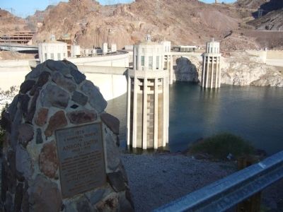
Anson Smith
1860 - 1935
Editor and Publisher of the Mohave County Miner, acclaimed by President Herbert Hoover for his tireless efforts and support during construction of Boulder Canyon Project and the location of . . . — — Map (db m46819) HM
The saguaro cactus before you owes its existence to the foresight of local residents. In the 1920s grazing and development threatened the saguaro's future. Saguaro forests began to disappear as mature cactuses were chopped to make way for new . . . — — Map (db m85355) HM
A cool canyon sanctuary at the confluence of two creeks
Mayhew Lodge, constructed of hand-smoothed logs and adorned with a towering rock chimney, was a rustic retreat attracting politicians, and movie stars. But this grand lodge had . . . — — Map (db m99273) HM
Soldiers from Camp Verde were early tourists to Sedona, enjoying the beauty, cooler temperatures and Oak Creek as a break from the camp.
As early as 1895, Lou Thomas turned Bear Howard’s cabin into a two-story hunting fishing lodge. It was there . . . — — Map (db m133684) HM
(Four markers are mounted on this pedestal.)Original Marker:
Diller-Chamberlain General Store
(Quong Lee Laundry)
726 Main Street
J.V. Diller had this one-story brick building constructed in 1859 to house his general . . . — — Map (db m202732) HM
This 1919 residence of a developing international style of architecture embodies Mrs. Herbert Hoover’s innovative architectural concepts. It was executed by architects A. B. Clark, Charles Davis, and Birge Clark, and was maintained as the Hoover . . . — — Map (db m2717) HM
It is as if God has set His sign, His seal, His promise there – a beacon upon the very center and height of the Continent to all its people and all its generations…as if here was a great supply store and workshop of Creation, the fountain . . . — — Map (db m58578) HM
Maria Skłodowska-Curie, born in 1867 in Warsaw, was a visionary scientist whose discoveries paved the way for effective cancer treatments and created the foundations of several scientific disciplines.
Maria Skłodowska-Curie was . . . — — Map (db m175121) HM
The Robert A. Taft Memorial Carillon
Sculpture by Wheeler Williams
Architecture by Douglas W. Orr, 1959
The memorial consists of a 100-foot Tennessee marble tower and a 10-foot bronze statue of Senator Taft. The twenty-seven . . . — — Map (db m111460) HM
Originally State, War, and Navy Departments Constructed 1871-1888 South Wing Ground broken June 1871 Completed December 1875 East Wing Ground broken July 1872 Completed April 1879 North Wing Ground broken July 1879 Completed December 1882 West . . . — — Map (db m71253) HM
Across the street the Department of Commerce's Herbert C. Hoover Building anchors the Federal Triangle, just as the department - with its mission of promoting trade, supporting economic development, and strengthening the competitiveness of . . . — — Map (db m57204) HM
The Flag. The immortal words "star-spangled Banner" refer to the magnificent flag which Francis Scott Key saw "by the dawn's early light" after the British bombardment of Fort McHenry on September 14, 1814. It is the largest flag ever flown in . . . — — Map (db m82470) HM
Born on July 10, 1875, in Mayesville, South Carolina, Mary McLeod Bethune was the daughter of sharecroppers. After attending Scotia Seminary in North Carolina she founded Daytona School for Negro Girls which became Bethune-Cookman College. A . . . — — Map (db m17502) HM
Beginning in the late 1950s, the community leadership of Mount Pleasant changed from the exclusive Citizens Association to an array of new players. Mount Pleasant Neighbors Association was the first alternative group. It presented festivals and . . . — — Map (db m148598) HM
Five presidents lived in Sheridan-Kalorama between 1916 and 1930. Warren G. Harding lived at 2314 Wyoming Avenue while a senator from Ohio. William Howard Taft lived across the street at 2215 Wyoming Avenue while Chief Justice of the Supreme Court . . . — — Map (db m112606) HM
The neighborhood of Woodley Park owes its name to the Woodley estate of Philip Barto Key (1767-1815). Key, uncle of Francis Scott Key, who wrote “Star Spangled Banner”, was an officer on the British side during the Revolutionary War. . . . — — Map (db m87469) HM
Follow Good Hope Road under the highway to your left to reach Anacostia Park, a longtime neighborhood oasis.
In 1914, after years of citizen requests, Congress directed the U.S. Army Corps of Engineers to "improve" the Anacostia River by . . . — — Map (db m130717) HM
Presidential Fans
a. Woodrow Wilson throws out the first pitch on Opening Day, 1916. National Photo Company.
b. Calvin Coolidge and Senators ace Walter Johnson, 1924. National Photo Company.
c. President Herbert . . . — — Map (db m179719) HM
A memorial to the armed forces from the District of Columbia who served their country in the World War
This memorial was erected through the voluntary subscriptions of the people of Washington • It was dedicated on Armistice Day Nineteen . . . — — Map (db m211379) WM
[Panel 1: northeast corner wayside.]
“This monument stands for men who fought not alone for their country, but to establish the principles of justice and peace. We pay tribute here to their valor. We honor them for their . . . — — Map (db m76573) HM
1 • Ponce de León Live Oak Planted on November 27, 2001 in memory of Eunice R. Rabette. The Ponce de León Live Oaks grow near the spot at Port Charlotte, Florida, where the explorer first came ashore in April 1513. 2 • Treaty Live . . . — — Map (db m214873) HM
Just as carefully as Branch Rickey chose Jackie Robinson, he chose Daytona Beach as the site for his "noble experiment.” Dr. Mary McLeod Bethune, founder of Bethune-Cookman College was born July 10, 1875, in Maysville, South Carolina. She was . . . — — Map (db m106464) HM
By an Act of Congress (P.L. 105-163) this historic building is named for United States District Judge "Gus" Bootle. Judge Bootle was born in Walterboro, S.C. on August 19, 1902, and attended Mercer University where he was awarded a law degree in . . . — — Map (db m130997) HM
Patriot, Ind., native; supervised Hoover Dam construction in Colorado R.; Lake Mead named for him; appointed Director, U.S. Bureau of Reclamation, President Coolidge; served under Presidents Hoover and Roosevelt, top authority on irrigation, . . . — — Map (db m66902) HM
“It was here that I was given that tender care of mind and body, those first steps in education, that knowledge of poverty and struggle for family betterment which contribute to understanding of American life.” President . . . — — Map (db m87749) HM
“My country owes me nothing. It gave me, as it gives every boy and girl, a chance . . . In no other land could a boy from a country village, without inheritance or influential friends, look forward with unbounded hope.” . . . — — Map (db m87751) HM
“My country owes me nothing. It gave me, as it gives every boy and girl, a chance...in no other land could a boy from a country village, without inheritance or influential friends, look forward with unbounded . . . — — Map (db m162568) HM
The Hoover family worshipped in this building along with neighbors and relatives who were members of the Religious Society of Friends, or Quakers as they are often called. West Branch was predominately a Quaker community in the 1850's when this . . . — — Map (db m48312) HM
This site commemorates the life and accomplishments of Herbert Hover, 31st President (1929-1932). The first president born west of the Mississippi River. Hoover grew up in a tradition that deeply influenced his ideals and long life of public . . . — — Map (db m48307) HM
Herbert Hoover, the first president born west of the Mississippi, spent his formative years in this neighborhood, which is preserved as Herbert Hoover National Historic Site. You may visit his birthplace and other buildings he remembered from his . . . — — Map (db m162574) HM
"This cottage where I was born is physical proof of the unbounded opportunity of American life."
In 1871, Jesse Hoover built this two-room cottage near his blacksmith shop and moved in with his wife, Hulda, and young son, Theodore. . . . — — Map (db m162633) HM
You are viewing 76 acres of partially restored tall grass prairie, planted in 1971. Extending from the historic Miles Farm, at the hilltop on your left, it provides a south western boundary for the historic site. Prior to the . . . — — Map (db m163147) HM
The early settlers of West Branch had a strong regard for education, and in 1853 they built this school. It was used not only as a school but as a place of worship for the members of the Society of Friends. Originally the building housed all of the . . . — — Map (db m162553) HM
Miss Amanda Garvin purchased this lot in 1870 and by 1872 had this small frame cottage built. She resided here until 1878. Herbert Hoover was familiar with this house and would have passed it often to and from school. The Garvin Cottage is . . . — — Map (db m162640) HM
Dr. L.J. Leech opened a medical practice in West Branch in 1882 and practiced here for the next 55 years. For many years he lived in the house one door to the north. In 1920 he moved to this home and lived here until his death in 1937. At his . . . — — Map (db m162609) HM
This house was built in 1899 for Hannah Varney. Mrs. Varney lived in the house only about one year, but her daughters Cora and Clara continued to live here until 1915. Although built some thirteen years after Herbert Hoover left West Branch, this . . . — — Map (db m162575) HM
This site is along the original route of the Herbert Hoover Highway, a 42-mile series of local, state and county roads that run between the foot of Old Capitol in Iowa City and the Cedar County community of Lowden. The Hoover Highway was designated . . . — — Map (db m76108) HM
Herbert Hoover’s distinguished uncle, Laban Miles, owned this house from 1875-1886, and Herbert would have visited the Miles family here on many occasions. In 1878 Laban Miles moved his family to the Oklahoma Territory where he had been appointed . . . — — Map (db m162578) HM
David Mackey, a local carpenter, built this house between 1868 and 1871. He lived in this home until 1876. Mackey also ran a butcher shop and served as mayor of West Branch in 1879 and postmaster in 1885. Built several years before his birth, this . . . — — Map (db m87736) HM
The Herbert Hoover National Historic Site, located in nearby West Branch, honors a distinguished son of Iowa, citizen of the world, and the 31st president of the United States. Established in 1965, the Site’s foundations were laid earlier when in . . . — — Map (db m224358) HM
The Herbert Hoover National Historic Site, located in nearby West Branch, honors a distinguished son of Iowa, citizen of the world, and the 31st president of the United States. Established in 1965, the Site’s foundations were laid earlier when in . . . — — Map (db m224363) HM
"I began to realize, as I never had before, how much the health of each of us depends on the health of all of us."
Frontier physician, public health visionary and child health advocate, Samuel J. Crumbine was a man of tremendous . . . — — Map (db m120812) HM
Twin Oaks - the name evokes a rural character long since lost to this part of Anne Arundel County. Built in 1857 by William Linthicum, this antebellum manor home presided over a 130-acre farm.
Twin oaks was the summer retreat of . . . — — Map (db m68392) HM
A monument to the golden era of rail travel, the Mount Royal Station enjoys a special place in the history of Baltimore and the nation—the home of the Baltimore & Ohio (B&O) Railroad and birthplace of American railroading. The history of the B&O . . . — — Map (db m208442) HM
Railroads built office cars for officials directors, stockholders, and other wealthy patrons as early as the 1840s. Used for right-of-way inspection trips and other business travel, these rolling offices provided an observation platform, . . . — — Map (db m135963) HM
About 1735 William Farquhar and Ann his wife held a Friends (Quaker) Meeting at his house. In 1771 he deeded two acres of land on which the Meeting House and burying ground are located. Ex-President Hoover’s ancestors were members of this Meeting. — — Map (db m3015) HM
Commercial development along upper Main Street followed the industrial expansion spurred by the Civil War. As Northampton became a manufacturing center, its business district expanded to accommodate a growing and changing population. In the 1860s . . . — — Map (db m138438) HM
St. Matthew's A.M.E. Church, organized in 1867 and originally located on Levee Street, was the first A.M.E. church established in the Delta and the fourth begun in Mississippi. Moved to its present site in 1890, this church was visited by Herbert . . . — — Map (db m107705) HM
In 1928, here at the Rock Island Railroad Depot, the Republican nominee for President was in Cameron. Local bridge builder J.C. Dildine and wife Rose, a member of the Republican State Committee, encouraged Hoover make a rear platform talk. But after . . . — — Map (db m221293) HM
The Beartooth Plateau contains some of the oldest exposed rocks on Earth and provides a unique window into the history of our planet. About 55 million years ago, this massive block of metamorphic basement rock pushed its way upward nearly two . . . — — Map (db m45251) HM
This hotel was built in 1895 by the Ely Valley Mines to house their guests. And lay claim to such overnight guests as Herbert Hoover, Nel Murbarger (Famous author of the "Old West") Many U.S. Senators and Nevada Governors and many other notables. . . . — — Map (db m89473) HM
Former Ritz Carlton Hotel opened during the "Roaring Twenties" on June 24, 1921 as one of Atlantic City's Grand Hotels.
Designed by the architectural firm of Warren and Wetmore and constructed at a cost of $6 million.
During WW2 the . . . — — Map (db m208348) HM
Plaque 1: This tower marks the site of the experimental laboratory built by Thomas Alva Edison, born Milan, Ohio, February 11, 1847. The laboratory structure occupied by the inventor from 1876 to 1886, was transported in 1929 by his friend . . . — — Map (db m33292) HM
The lawyer and former New York governor lived here from 1917 to 1921, after losing the 1916 presidential elections to Woodrow Wilson. Hughes served as U.S. Secretary of State during the Harding Administration (1921-23) and the Coolidge . . . — — Map (db m98645) HM
Heads of State
who visited the
New York Worlds Fair
1939 - 1940
Herbert C. Hoover, USA •
Franklin D. Roosevelt, USA •
George VI, Great Britain •
Anastasio Somoza, Nicaragua
1964 - 1965
Herbert C. Hoover, USA •
Harry . . . — — Map (db m193429) HM
Susan Brownell Anthony
Woman Suffrage Leader
Visited October 19, 1878
"To secure both national and 'domestic tranquility,' to 'establish justice,' to carry out the spirit of our Constitution, put into the hands of all women....the . . . — — Map (db m53838) HM
Plaque A
“River Ohio so called by the Iroquois on account
of its beauty- descended by Sieur Robert de la Salle.”
Discovered by the French explorer LaSalle, about
1670 and claimed by him for Louis XIV of France.
Seized by the . . . — — Map (db m135159) HM
Warren Gamaliel Harding
Warren Gamaliel Harding was born November 2, 1865, in Blooming Grove, Ohio, to Dr. George Tryon Harding and Phoebe Dickerson Harding. The family moved to the village of Caledonia, and then to Marion.
Harding . . . — — Map (db m219208) HM
Patterson Bridge
(Rogue River Bridge)
Completed January 21, 1932 and dedicated In Memory to the Governor of Oregon Isaac Lee Patterson (1926-died in office 1929)
1932.... The bridge was considered the most advanced concrete . . . — — Map (db m113391) HM
Construction of the Old Post Office established the presence of the federal government in this area.
It was a project of the Public Buildings Program, a federal agency created by President Herbert Hoover.
As one of the first buildings with . . . — — Map (db m113264) HM
Canyon Formation
Constant flow of water over the volcanic basalt rock carved the 2,100-foot long canyon. With no way for the water to expand to the sides, the river bed was forced to depths of about 100 feet.
Evolution of . . . — — Map (db m112805) HM
For wounds or death in any action
against an enemy of the United States
as a result of an act of such enemy.
Established by General George Washington on Aug. 7, 1782,
as the Badge of Military Merit for unusual gallantry, . . . — — Map (db m232248) HM WM
Long before it was a busy commercial corridor. Walnut Street was a fashionable residential address. But by 1930, the wealthy occupants of houses like these on the 1200 block had moved on, to mansions at Rittenhouse Square and elsewhere, and the . . . — — Map (db m191885) HM
The Western Union Telegraph Building at 1111 Locust Street was designed in the Egyptian Revival style in 1922 by architect William Welles Bosworth, known for designing the main campus of the Massachusetts Institute of Technology. The entrance is . . . — — Map (db m192727) HM
Having served as Secretary of Commerce under Presidents William Harding and Calvin Coolidge, President Hoover, educated as a mining engineer, was the last Cabinet secretary to be directly elected President of the United States without . . . — — Map (db m193242) HM
This part of Bellevue Avenue reflects the architectural variety of 19th century Newport houses, from the Gothic Revival and Second Empire French villas of the early 1850s to the Stick Style cottages of the 1870s and the Beaux Arts Classical . . . — — Map (db m48591) HM
The land you are standing on has not always been protected by the National Park Service. For 200 years after the battle, homes, farms, and other businesses occupied the 842 acres that make up Cowpens National Battlefield.
Although Congress . . . — — Map (db m108656) HM
On this Site
President Hoover
Addressed an audience of 75,000
at the Celebration of the
Sesqui Centennial
of the Battle of Kings Mountain
Oct. 7, 1930 — — Map (db m125171) HM
This is a place of inspiring memories.
Here less than a thousand men, inspired by the urge of freedom, defeated a superior force....This small band of patriots turned back a dangerous invasion well-designed to separate and dismember the . . . — — Map (db m17535) HM
Due to the efforts of businessman Jesse H. Jones, the Democratic National Committee chose Houston as the site of the 1928 Democratic National Convention. Located on this site, the 20,000-seat Sam Houston Hall was completed in 64 days at a cost of . . . — — Map (db m116847) HM
The Connecticut River, starting at the International Boundary, flows 380 miles to the Atlantic Ocean. In its course the river falls 1640 feet. In 1928, the New England Power Association started a two-year project to build one of the largest . . . — — Map (db m74467) HM
Locomotive 220 was the last coal-burning steam ten-wheeler used on the Central Vermont Railway. As a medium-sized engine it moved both freight and passenger trains and became known as the [sic] "The Locomotive of Presidents" for its use on special . . . — — Map (db m109152) HM
The Rail Locomotive No. 220, built in 1915 by the American Locomotive [C]ompany of Schenectady, New York, was the last coal-burning, steam ten-wheeler used on the Central Vermont Railway. As a medium-sized 4-6-0 engine (4 leading wheels, 6 driving . . . — — Map (db m109153) HM
Greene County. Formed from Orange County in 1838, this rural Piedmont county was named for Gen. Nathanael Greene, Revolutionary War military hero. The county seat of Greene County is Stanardsville. William Donoho and William B. Phillips, . . . — — Map (db m21505) HM
Madison County.
In the hills of the Piedmont, along the Blue
Ridge Mountains, Madison County was formed
from Culpeper County in 1792. Madison
County is named for James Madison, the
“father of the American Constitution” and
the forth . . . — — Map (db m104880) HM
Madison County. In the hills of the Piedmont, against the Blue Ridge Mountains, Madison County was formed from Culpeper County in 1792. The county is named for James Madison, the “father of the American Constitution” and the fourth president . . . — — Map (db m21502) HM
Met here with the citizens of Madison County as their neighbor and friend and eloquently thanked them for their hospitality.
Speaking of his fishing camp at the headwaters of the Rapidan River, Mr. Hoover concluded his remarks with these . . . — — Map (db m152167) HM
Orange County. Formed from Spotsylvania County in 1734, Orange County, a pastoral Piedmont county, was probably named in honor of William IV, the Dutch prince of Orange, who married Anne, the Princess Royal, daughter of George II of . . . — — Map (db m4758) HM
“Here is peace and quietude.”- President Herbert Hoover Shortly after his election in 1928, Herbert C. Hoover and his wife, Lou Henry, expressed the desire for a weekend retreat – a place where they could find respite . . . — — Map (db m45639) HM
We discussed the proposed camp as we explored . . . . Conditions necessitate A Rather biggish establishment - Lou Henry Hoover, describing the future Rapidan Camp, 1929 I have discovered that even the work of the government can be improved . . . — — Map (db m45677) HM
Presidential Aids who were stationed at the camp say that this fireplace was mainly used for outdoor photographs. When reporters and authors wanted pictures of the Chief Executive and his guests they were often posed here. Logs, used for benches, . . . — — Map (db m45626) HM
The Creel was occupied by two of President Hoover’s Chief Aids, Larry Richey, a former F.B.I. agent, was assigned to guard the President and became his personal “secretary” or manager. He assumed great responsibility for the detailed . . . — — Map (db m45619) HM
Although Camp Hoover was rustic, it was comfortably furnished with a mixture of styles. The Hoovers had many Navajo rugs which they used throughout their cabin. Above is a sunporch and below the Hoovers’ bedrooms. — — Map (db m45612) HM
Prime Minister Ramsey McDonald of England was a frequent guest of President Hoover. The “Press” of that day popularly envisioned these two peace loving leaders sitting on a log in the Camp Hoover area scrapping the navies of the world. . . . — — Map (db m45616) HM
Did You Know?
Apple of Their Eye
Apples were a cash crop for the people who lived in what is now Shenandoah National Park. Former residents raised different types of apples-some of which were actually created here-including the . . . — — Map (db m230918) HM
On May 31, 1928, President Calvin Coolidge accepted former Senator Irvine Lenroot's invitation to spend the summer in the Superior area. Henry Clay Pierce had offered Cedar Island Lodge, part of a 4,000 acre Brule River estate, to serve as living . . . — — Map (db m52127) HM
Thomas Mellon was born in this cottage on February 3rd, 1813. It was built by his father and uncle a few years earlier "chiefly by the labour of their own hands" and stood on a Twenty-three acre farm cut out of his grandfather's larger estate. . . . — — Map (db m85967) HM