82 entries match your criteria.
William Bartram Trails Historical Markers
William Bartram traveled the Southeast United States from 1773 through 1777. He published observations of plants, animals, geography and people in 1791. Bartram's Travels remains in print to the present.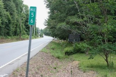
By TRCP Alliance, June 22, 2013
Bartram’s Trail Marker
| 1 ► Alabama, Baldwin County, Stockton — Bartram’s Trail — |
| On Alabama Route 59 at milepost 56, on the right when traveling north. | |||
| 2 ► Alabama, Baldwin County, Stockton — Major Robert Farmar Plantation — |
| On Alabama Route 225 just north of Lower Bryants Landing Road, on the left when traveling north. | |||
| 3 ► Alabama, Butler County, Greenville — Bartram's Trail — |
| On Sherling Lake Road (County Road 44) 1 mile west of Braggs Road (State Route 263), on the right when traveling west. | |||
| 4 ► Alabama, Clarke County, Rockville — Bartram's Trail — |
| On Rockville Road (County Road 15) at Stimpson Sanctuary Road, on the right when traveling south on Rockville Road. | |||
| 5 ► Alabama, Elmore County, Wetumpka — Bartram's Trail — |
| On West Fort Toulouse Road, 0.1 miles west of U.S. 231, on the right when traveling west. | |||
| 6 ► Alabama, Macon County, Tuskegee — Bartram's Trail — |
| On Forest Road 949, 0.2 miles north of State Route 186, on the left when traveling north. | |||
| 7 ► Alabama, Mobile County, Grand Bay — William Bartram Trail — Traced 1773-1777 — Deep South Region — |
| Near Interstate 10, 2 miles east of Franklin Creek Road. | |||
| 8 ► Alabama, Russell County, Fort Mitchell — Bartram's Trail — |
| On Alabama Route 165 north of Creek Trail, on the right when traveling north. | |||
| 9 ► Florida, Alachua County, Hawthorne — F-212 — Hawthorne — |
| On 221st Street near 65th Avenue, on the right when traveling south. | |||
| 10 ► Florida, Alachua County, Micanopy — F-75 — William Bartram — (1739-1823) — |
| On NE Cholokka Blvd (County Road 234), on the left. | |||
| 11 ► Florida, Alachua County, Newberry — William Bartram Trail — Traced 1773 - 1777 — Deep South Region — |
| On US Hwy 27 & 41 (U.S. 27) at Northwest 16th Avenue, on the right when traveling north on US Hwy 27 & 41. | |||
| 12 ► Florida, Brevard County, Wilson — William Bartram Trail — Traced 1773 - 1777 — Deep South Region — |
| Near Playalinda Road, 4 miles north of A. Max Brewer Memorial Parkway, on the left when traveling north. | |||
| 13 ► Florida, Brevard County, Wilson — William Bartram Trail — Traced 1773 - 1777 — Deep South Region — |
| Near Playalinda Road, 2.2 miles north of A. Max Brewer Memorial Parkway. | |||
| 14 ► Florida, Escambia County, Pensacola — William Bartram Trail — Traced 1773-1777 — Deep South Region — |
| On East Main Street (County Road 196) at South Alcaniz Street, on the right when traveling east on East Main Street. | |||
| 15 ► Florida, Escambia County, Pensacola — William Bartram Trail — Traced 1773-1777 — Deep South Region — |
| Near South Pace Boulevard, 0.1 miles south of Cypress Street when traveling south. | |||
| 16 ► Florida, Indian River County, Sebastian — William Bartram Trail — Traced 1773 - 1777 — Deep South Region — |
| On U.S. 1 at Sebastian Boulevard, on the right when traveling north on U.S. 1. | |||
| 17 ► Florida, Marion County, Salt Springs — William Bartram Trail — Traced 1773 - 1777 — Deep South Region — |
| On State Road 19, 0.2 miles south of County Road 316 (County Road 316), on the right when traveling south. | |||
| 18 ► Florida, Nassau County, Fernandina Beach — William Bartram Trail — Traced 1773-1777 — Deep South Region — |
| On S Front Street near Centre Street, on the right when traveling north. | |||
| 19 ► Florida, Putnam County, East Palatka — William Bartram Trail — Deep South Region — Traced 1773 - 1777 — |
| On U.S. 17, on the right when traveling south. | |||
| 20 ► Florida, Putnam County, Palatka — Bartram Trail in Putnam County — The Playgrounds at Puc-Puggy Landing — |
| Near Memorial Parkway at Laurel Street, on the right when traveling north. | |||
| 21 ► Florida, Putnam County, Palatka — William Bartram Trail — Traced 1773-1777 — Deep South Region — |
| Near Twigg Street near Moseley Avenue. | |||
| 22 ► Florida, Putnam County, Palatka — William Bartram's Travels — |
| On Memorial Parkway just east of South Second Street, on the right when traveling north. | |||
| 23 ► Florida, Putnam County, Welaka — F-411 — The Mount Royal Site — |
| On County Road 309 at Fort Gates Ferry Road, on the right when traveling south on County Road 309. | |||
| 24 ► Florida, Seminole County, Longwood — William Bartram Trail — Traced 1773-1777 — Deep South Region — |
| Near Interstate 4 at milepost 96,, 2.5 miles east of State Road 434, on the right when traveling east. | |||
| 25 ► Florida, Seminole County, Oviedo — White’s Wharf — (Clifton Springs) — |
| Near Spring Avenue, 0.1 miles south of Lake Street, on the left when traveling north. | |||
| 26 ► Florida, St. Johns County, Green Cove Springs — F-514 — William Bartram's Plantation — |
| On State Road 16, 0.8 miles west of State Road 13 (State Road 13), on the right when traveling east. | |||
| 27 ► Florida, St. Johns County, Picolata — William Bartram Trail — Traced 1773-1777 — Deep South Region |
| On County Road 13, 0.5 miles north of County Road 208, on the right when traveling south. Reported missing. | |||
| 28 ► Florida, St. Johns County, St. Augustine — William Bartram Trail — Traced 1773-1777 — Deep South Region — |
| Near Anastasia Boulevard (State Highway A1A) 0.1 miles south of Madeira Drive, on the left when traveling south. | |||
| 29 ► Florida, St. Johns County, Switzerland — William Bartram Scenic Highway — |
| On State Road 13, on the left when traveling north. | |||
| 30 ► Florida, St. Johns County, Switzerland — William Bartram Trail — Traced 1773 - 1777 — Deep South Region — |
| On William Bartram Scenic Highway (State Road 13), on the left when traveling north. | |||
| 31 ► Florida, Volusia County, DeLand — Bartram Gardens & Trail — Volusia County Bartram Trail — |
| Near Kalua Way just north of Alhambra Avenue, on the right when traveling north. | |||
| 32 ► Florida, Volusia County, DeLand — Bartram in Volusia County — Volusia County Bartram Trail — |
| Near Kalua Way just north of Alhambra Avenue, on the right when traveling north. | |||
| 33 ► Florida, Volusia County, DeLand — Bartram's Birds — Volusia County Bartram Trail — |
| Near Kalua Way just north of Alhambra Avenue, on the right when traveling north. | |||
| 34 ► Florida, Volusia County, DeLand — Bartram's Fish — Volusia County Bartram Trail — |
| Near Kalua Way just north of Alhambra Avenue, on the right when traveling north. | |||
| 35 ► Florida, Volusia County, DeLand — Bartram's Plants — Volusia County Bartram Trail — |
| Near Kalua Way just north of Alhambra Avenue, on the right when traveling north. | |||
| 36 ► Florida, Volusia County, DeLand — Red Cedar — Juniperus virginiana — Bartram Garden — |
| Near Kalua Way just north of Alhambra Avenue, on the right when traveling north. | |||
| 37 ► Florida, Volusia County, DeLand — Southern Magnolia — Magnolia grandiflora — Bartram Garden — |
| Near Kalua Way just north of Alhambra Avenue, on the right when traveling north. | |||
| 38 ► Florida, Volusia County, DeLand — Who was William Bartram? — Bartram Garden — |
| Near Kalua Way just north of Alhambra Avenue, on the right when traveling north. | |||
| 39 ► Florida, Volusia County, DeLand — William Bartram Trail — Traced 1773-1777 — Deep South Region — |
| Near River Ridge Road (County Road 4125) 0.8 miles south of Hontoon Road. | |||
| 40 ► Florida, Volusia County, Orange City — Bartram at Blue Spring — Volusia County Bartram Trail — |
| Near Magnolia Avenue (Becker Boulevard), 1 mile south of West French Avenue. | |||
| 41 ► Florida, Volusia County, Volusia — William Bartram Trail — Traced 1773-1777 — Deep South Region — |
| On State Road 40 at Alice Drive, on the right when traveling west on State Road 40. | |||
| 42 ► Georgia, Athens-Clarke County, Athens — William Bartram Trail — Traced 1773-1777 — Deep South Region — |
| On the State Botannical Garden entrance road, 0.2 miles west of S. Milledge Avenue, on the right when traveling west. | |||
| 43 ► Georgia, Bibb County, Macon — William Bartram Trail — Traced 1773–1777 — Deep South Region — |
| On the park road south of Emery Highway (U.S. 80). | |||
| 44 ► Georgia, Bibb County, Macon — William Bartram Trail — Traced 1773-1777 — |
| On Colonial Station Drive, 0 miles south of Columbus Road, on the right when traveling south. | |||
| 45 ► Georgia, Burke County, Waynesboro — 25 B-4 — Shell Bluff — |
| On North Liberty Street (U.S. 25) at East 7th Street, on the right when traveling north on North Liberty Street. | |||
| 46 ► Georgia, Chatham County, Savannah, Historic District - North — William Bartram Trail — Traced 1773-1777 — Deep South Region — |
| On W. River Street near N. Barnard St., on the left. | |||
| 47 ► Georgia, Crawford County, Knoxville — William Bartram Trail — Traced 1773-1777 — Deep South Region — |
| On East Agency Street (Georgia Route 42) at Hartman Mill Road, on the right when traveling west on East Agency Street. | |||
| 48 ► Georgia, Crawford County, Roberta — William Bartram Trail — Traced 1773-1777 — Deep South Region — |
| On East Agency Street at Hicks Road, on the left when traveling east on East Agency Street. | |||
| 49 ► Georgia, Crawford County, Sandy Point — William Bartram Trail — Traced 1773-1777 — Deep South Region — |
| On Carl Sutton Road, 0.4 miles north of Sandy Point Road, on the right when traveling north. | |||
| 50 ► Georgia, Effingham County, Rincon — William Bartram Trail — Traced 1773-1777 — Deep South Region — |
| On Ebenezer Road (Route 275) near Old Augusta Road (County Route 284), on the left when traveling north. | |||
| 51 ► Georgia, Glynn County, St. Simons Island — William Bartram Trail — Traced 1773-1777 — Deep South Region — |
| On Mimosa Dr, on the left when traveling west. | |||
| 52 ► Georgia, Liberty County, Riceboro — William Bartram Trail — Traced 1773-1777 — Deep South Region — |
| On Barrington Ferry Road, 1 mile south of Sandy Run Road. | |||
| 53 ► Georgia, Lincoln County, Lincolnton — William Bartram Trail — Traced 1773-1777 — Deep South Region — |
| On Coach Jimmy Smith Highway (U.S. 378) at Old Petersburg Road (Georgia Route 43 Conn), on the right when traveling east on Coach Jimmy Smith Highway. | |||
| 54 ► Georgia, Madison County, Danielsville — William Bartram Trail — Traced 1773 – 1777 — Deep South Region — |
| On Old Wildcat Bridge Road (County Route 399) at John Conant Drive, on the left when traveling east on Old Wildcat Bridge Road. | |||
| 55 ► Georgia, Marion County, Buena Vista — William Bartram Trail — Traced 1773-1777 — Deep South Region — |
| On State Highway 41 at County Route 56, on the left when traveling north on State Highway 41. | |||
| 56 ► Georgia, McDuffie County, Thomson — William Bartram Trail — Traced 1773-1777 — Deep South Region — |
| On Wrightsboro/Stagecoach Road, 4 miles west of U.S. 78, on the left when traveling west. | |||
| 57 ► Georgia, McIntosh County, South Newport — William Bartram Trail — Traced 1773-1777 — Deep South Region — |
| On Coastal/Ocean Highway (U.S. 17), on the right when traveling south. | |||
| 58 ► Georgia, Muscogee County, Columbus — William Bartram Trail — Traced 1773-1777 — Deep South Region — |
| On Broadway at Fourth Street, in the median on Broadway. | |||
| 59 ► Georgia, Oglethorpe County, Arnoldsville — William Bartram Trail — Traced 1773-1777 — Deep South Region — |
| On Athens Road (U.S. 78) at Moss Creek Road, on the right when traveling west on Athens Road. | |||
| 60 ► Georgia, Rabun County, Clayton — William Bartram Trail — Traced 1773-1777 — Deep South Region — |
| On Warwoman Road (County Route 219) 2.7 miles east of U.S. 441, on the right when traveling east. | |||
| 61 ► Georgia, Richmond County, Augusta — William Bartram Trail — Traced 1773-1777 — Deep South Region — |
| Near 8th Street. | |||
| 62 ► Georgia, Richmond County, Augusta — 121-7 — William Bartram Visited Augusta, 1773. — |
| Near E. Ford Street near Telfair Street. | |||
| 63 ► Georgia, Talbot County, Talbotton — William Bartram Trail — Traced 1773-1777 — Deep South Region — |
| On Georgia Route 41 at Clark Street (Route 90), on the right when traveling north on State Route 41. | |||
| 64 ► Georgia, Taliaferro County, Crawfordville — 131-9 — The Common Road of the English Following Old Indian Trail — |
| On Broad Street (U.S. 278) at Monument street, on the right when traveling west on Broad Street. | |||
| 65 ► Georgia, Taylor County, Butler — William Bartram Trail — Traced 1773-1777 — Deep South Region — |
| On Georgia Route 137 at Fickling Mill Road, on the right when traveling west on State Route 137. | |||
| 66 ► Louisiana, East Baton Rouge Parish, Baton Rouge — William Bartram Trail — Traced 1773-1777 — |
| On South Boulevard at River Road (State Road 327), on the right when traveling west on South Boulevard. | |||
| 67 ► Louisiana, East Baton Rouge Parish, Baton Rouge — William Bartram Trail — Traced 1773-1777 — |
| Near Airline Highway (U.S. 61) 1 mile south of Highland Road (State Highway 42), on the right when traveling south. | |||
| 68 ► Louisiana, East Baton Rouge Parish, Baton Rouge, Highlands/Perkins — William Bartram Trail — Traced 1773-1777 — |
| Near Essen Lane (State Highway 3064) at Interstate 10, on the right when traveling south. | |||
| 69 ► Louisiana, East Baton Rouge Parish, Baton Rouge, Highlands/Perkins — William Bartram Trail — Traced 1773-1777 — |
| Near Nicholson Drive (State Highway 30) north of West Johnson Street, on the right when traveling north. | |||
| 70 ► Louisiana, East Baton Rouge Parish, Baton Rouge, Mid City South — William Bartram Trail — Traced 1773-1777 — |
| Near Goodwood Boulevard, 0.2 miles west of East Airport Avenue, on the right when traveling west. | |||
| 71 ► Louisiana, East Baton Rouge Parish, Baton Rouge, Oak Hills Place — William Bartram Trail — Traced 1773-1777 — |
| Near Highland Road (Louisiana Route 42) west of Oak Hills Parkway, on the right when traveling west. | |||
| 72 ► Louisiana, East Baton Rouge Parish, Zachary — William Bartram Trail — Traced 1773-1777 — |
| On Plains-Port Hudson Road at Old Scenic Highway (Louisiana Highway 964), on the right when traveling east on Plains-Port Hudson Road. | |||
| 73 ► Louisiana, Livingston Parish, Port Vincent — William Bartram Trail — Traced 1773-1777 — |
| On Louisiana Route 42, 0.2 miles east of Louisiana Route 431, on the right when traveling east. | |||
| 74 ► Louisiana, Pointe Coupee Parish, New Roads — William Bartram Trail — Traced 1773-1777 — |
| On Pointe Coupee Road (State Highway 420) 0.5 miles north of Airport Road, on the right when traveling north. | |||
| 75 ► Mississippi, Harrison County, Biloxi — William Bartram Trail — |
| Near Beach Boulevard (U.S. 90) at Main Street, on the right when traveling east. | |||
| 76 ► North Carolina, Macon County, Franklin — The North Carolina Bartram Trail — |
| On Phillips Street at West Main Street (Business U.S. 441), on the right when traveling north on Phillips Street. | |||
| 77 ► North Carolina, Macon County, Franklin — William Bartram Naturalist — |
| On West Main Street (Business U.S. 441) at Iotla St (Local Highway 1323), on the right when traveling west on West Main Street. | |||
| 78 ► North Carolina, Macon County, Topton — Q-44 — William Bartram — |
| On U.S. 74, on the right when traveling east. | |||
| 79 ► South Carolina, Abbeville County, Abbeville — William Bartram Trail — Traced 1773-1777 — South Atlantic Region — |
| On State Highway 71, 0.5 miles east of County Road 1-63. | |||
| 80 ► South Carolina, Aiken County, Jackson — William Bartram Trail — Traced 1773-1777 — South Atlantic Region — |
| Near Silver Bluff Road (County Highway 314) 0.4 miles north of Bluff Landing Road (County Highway 315), on the left when traveling north. | |||
| 81 ► South Carolina, Horry County, Myrtle Beach — William Bartram Trail — Traced 1773–1777 — South Atlantic Region — |
| On Ocean Boulevard (State Highway 73) at South 20th Avenue, on the right when traveling north on Ocean Boulevard. | |||
| 82 ► South Carolina, Oconee County, Salem — 37-3 — The Cherokee Path — |
| On Cherokee Foothills Scenic Highway (SC Highway 11). | |||