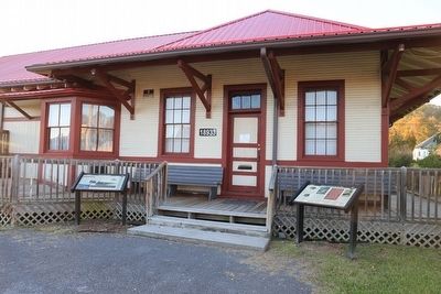
The Coal Heritage Trail is a driving trail that winds through more than (13 counties) 187 rugged miles of scenic industrial heritage, where thousands of hard-working miners labored to produce the coal which created modern America.
The Clinchfield Railroad (1902–1983) which runs 277 miles from Spartansburg, SC to Elkhorn City, KY was built originally to haul coal and timber from the mountains
to the markets. The first
passenger train stopped in Dungannon, Virginia . . . — — Map (db m90943) HM
Prehistoric hunters and gatherers traveled this land more than 10,000 years ago and later Native Americans settled here about A.D. 800. From evidence recovered by the Archaeological Society of Virginia in 1977, it appears that Indians camped at the . . . — — Map (db m90958) HM
The Coal River is a tributary of the Kanawha River in southern West Virginia. It is formed near the community of Alum Creek by the confluence of the Big and Little Coal Rivers. The Coal River flows generally northward through western Kanawha County, . . . — — Map (db m137542) HM
The Birdman of West Virginia
When thinking of the early aviation history of the United States, many times we think of Dayton or Kitty Hawk. However, the town of Ansted also holds a very special place in the story, as it was the birthplace of . . . — — Map (db m173335) HM
Like many other areas of West Virginia, coal mining has played an important role in the history of Ansted and the surrounding area. Soon after the 1873 completion of the Chesapeake and Ohio Railroad, coal mines began springing up in the New River . . . — — Map (db m173339) HM
First mentioned by Captain Thomas Battes as he and others surveyed the area in 1671, the first settlers in what is now Ansted can be traced to 1790 when the families of James Lykens, James Taylor, Bailey Wood, and William Parrish arrived. The . . . — — Map (db m252552) HM
William Nelson Page became one of the leading managers and developers of West Virginia's coalfields in the late 19th and early 20th centuries, with much of his time being spent here in Ansted. While president of the Gauley Mountain Coal Company, . . . — — Map (db m173338) HM
You may find it hard to believe that the New River Gorge was once teeming with activity. Coal mining dominated the economy and social structure of the state of West Virginia between 1875 and 1950. During this time over forty coal mining towns were . . . — — Map (db m165274) HM
With railroads came thousands of workers looking to make a new life in the coalfields. In the late 1800’s and well into the mid-1900’s, many Appalachian miners lived in company towns called “Coal Camps”.
Mine operators built . . . — — Map (db m34443) HM
Welcome to the Mount Hope Historic Walking Trail. Walk along the sidewalks of Mount Hope and take a step back in time as you make your way through the heart of downtown. Hear stories of how the New River Company not only shaped the town but the . . . — — Map (db m242620) HM
The New River Company was a leader in the safety-first movement which swept through the state's mining communities during the 1920s and 1930s. The company established first aid teams at each of its operations, and each year they competed in a . . . — — Map (db m242625) HM
The New River field is one of the smokeless coal producing regions of southern West Virginia. It takes its name from the New River that generally bisects the field from north to south. Coal that produced little smoke when burned was very desirable . . . — — Map (db m242623) HM
On the morning of July 23. 1966, an explosion tore through an area of the Mount Hope Siltix Mine that was being operated by the New River Company. The blast, caused by the ignition of built-up methane gas, killed seven men and wounded two others who . . . — — Map (db m228744) HM
The turn of the 20th century brought the birth of two of the most important coal companies in the New River field: the McKell Coal & Coke Company and the New River Company. Thomas McKell's company was organized in 1893 to lease coal lands to . . . — — Map (db m242626) HM
As Mt. Hope emerged, there occurred one of the most important events in the state's history: the Chesapeake & Ohio Railroad, routed through the New River Gorge, was completed in 1873. The C&O was the first railroad to enter southern West Virginia . . . — — Map (db m242622) HM
Coal companies often paid miners in scrip, a form of private money, each coal company issuing their own scrip. So that it would not be confused with American currency, most of the coins had some sort of hole in the middle. Company allowed miners . . . — — Map (db m238103) HM
“Say a prayer for those who died in darkness so we may enjoy the sunlight.” —Inscription on the miners’ memorial in Whipple erected by the Knights of Columbus.
The most dreaded sound in the coal
camp was when the . . . — — Map (db m140365) HM
The United Mine Workers of America sought to protect coal
miners and began to agitate for better working conditions
throughout the nation. But, it was difficult to organize the West
Virginia miners’ union because of the ultimate control . . . — — Map (db m140168) HM
In the late 1800s, speculators, mining companies and investors were attracted to the vast,
untapped seams of coal lying under the West
Virginia mountains. The first coal operators
created company towns, or coal camps, where
everything was . . . — — Map (db m140429) HM
Pioneers settled the White Oak Valley in the 1800s. In 1892 the mineral rights were sold and the White Oak Fuel Company and the Whipple Colliery Company sunk five mine shafts at Whipple, Carlisle, Oakwood, Scarbro and Wingrove. Each of the five coal . . . — — Map (db m140403) HM
Like so many of the mining companies in the Pocahontas field, Ashland Coal & Coke Company was
organized by men from the Pennsylvania anthracite region. Several of the original stockholders were from
Ashland, Pennsylvania, and for this reason, the . . . — — Map (db m178968) HM
From the perspective of the coal company, the company store had a vital economic function. In an age when sixty percent of the mine’s cost of production consisted of wages, it ensured that the flow of money was circular. Miners’ wages flowed . . . — — Map (db m178984) HM
Throughout much of the history of mining, miners have been hampered in their efforts to earn a living wage by the lack of steady work. In the years prior to the 1930s, when unionization and mechanization of loading began to change the industry, the . . . — — Map (db m178974) HM
Ashland is located along the North Fork of Elkhorn Creek, one of the most heavily developed coal regions in the Pocahontas field. At its height, the North Fork valley held an estimated ten thousand people, some of whom worked for the Ashland Coal . . . — — Map (db m178973) HM
Child labor was common in West Virginia during the hand loading era, which took place from the onset of coal mining in the 19th century until around 1930. Mining was a skilled craft, and it took a number of years to learn. A young miner usually . . . — — Map (db m178964) HM
Within a ten month period, two devastating floods impacted McDowell County and its residents. The first major flood occurred on Sunday, July 8, 2001, after
a series of heavy thunderstorms dropped over eight inches of rain. By early afternoon, the . . . — — Map (db m252085) HM
cDowell County had the largest concentration of African
Americans in the West Virginia coal fields. Between the 1870s and 1900s, African Americans came to West Virginia to construct the Norfolk & Western, Chesapeake & Ohio, and the Virginian . . . — — Map (db m178858) HM
The town of Kimball was named for Frederick Kimball, Norfolk and Western Railway’s (N&W, now Norfolk Southern Corporation) second president—serving from 1881-1903. Frederick Kimball was a civil engineer with an interest in geology who helped to . . . — — Map (db m178876) HM
Dr. Roscoe Conklin Harrison was born on
February 19, 1880, in Raleigh N.C.
When he was about 17 years old, he went to the coal
fields of West Virginia, where the wages were attractive.
He was viewed as hardworking and industrious . . . — — Map (db m278313) HM
Frederick James Kimball (1844-1903) was responsible for the Norfolk & Western Railway being built through McDowell County. Kimball was born on March 6,1844, in Philadelphia, Pennsylvania. He worked for railroad companies in Pennsylvania and England . . . — — Map (db m178855) HM
The West Vivian Tunnel (approximately 820 feet west of this sign) was constructed about 1907 by the Norfolk and Western Railway (N&W, now Norfolk Southern Corporation), and is named for a small unincorporated community about one mile east of . . . — — Map (db m178956) HM
This is the site of Henrietta Dismukes Hospital and Nurses’ Home. The hospital burned down in 2016, and all that remains is the Nurses’ Home.
Dr. Henry Dodford Dismukes was born on August 11, 1889, in Troy, Alabama. His mother was . . . — — Map (db m278203) HM
In the early 1920s, David Houston, a prominent coal baron and owner of the Houston Coal and Coke Company, built the Houston Company Store. Unlike other company stores, the Houston Company Store was built on the edge of Carswell Hollow along Route . . . — — Map (db m178862) HM
In the 1920s, a group of World War I veterans approached the McDowell County Commission to discuss their plans for building a
new memorial that would recognize African American veterans. The county approved the plan and set aside $25,000 for the . . . — — Map (db m178735) HM
In the early 1900s, McDowell County had a large and diverse ethnic population. Most of the immigrants came from Europe with the largest concentration from Italy, Hungary, Russia, Poland, and Austria. Smaller numbers traveled from Australia, . . . — — Map (db m178621) HM
The McDowell County Courthouse was the site of a significant event in West Virginia’s Mine Wars. On August 1, 1921, Sidney “Sid” Hatfield, former Matewan Chief of Police and hero to union coal miners, and his friend, Deputy Ed Chambers, arrived at . . . — — Map (db m178569) HM
The topography of Welch and surrounding area consists of steep hills, V-shaped valleys, and sharp ridges. Welch is tucked into this rugged terrain, with the town built on the narrow valley floor—less than 1,000 feet wide in places—of Tug Fork and . . . — — Map (db m178535) HM
Captain Isaiah Arnold Welch (circa 1824-1902) was a land surveyor, civil engineer, and captain in the Confederate Army. Welch was hired by Major Jedediah Hotchkiss, a cartographer, to survey the coal and timber values in southern West Virginia. . . . — — Map (db m178572) HM
On February 20, 1858, the General Assembly of Virginia passed legislation creating
McDowell County from the western section of Tazewell County. McDowell County was named in honor of James McDowell, the governor of Virginia between 1843 and 1846, . . . — — Map (db m178627) HM
The McDowell County Courthouse stands on a grassy lot overlooking Wyoming Street.
Welch was selected as the county seat after a lengthy debate ever its location. Prior to the
1892 election, the courthouse had been located in Perryville and . . . — — Map (db m178550) HM
Welch is named for Captain Isaiah Welch, a surveyor whose accounts of rich coal seams in the Elkhorn Valley helped encourage development of the Norfolk and Western Railway (N&W, now Norfolk Southern Corporation). In 1888 Captain Welch bought land . . . — — Map (db m178524) HM
Bluefield, West Virginia had its beginnings as a flagstop at the farm of John Higginbotham, along the Norfolk and Western Railway (N&W, now Norfolk Southern Corporation) line reaching west from Roanoke. Known in 1884 as Higginbotham’s Summit, the . . . — — Map (db m305233) HM
Points of Interest ~
Ansted* – Visit the Ansted Heritage Museum, Hawks Nest State Park, or take a hike on the Ansted Rail Trail.
Ashland – Locally made crafts may be purchased at the restored Ashland Company . . . — — Map (db m304941) HM
In 1887, 442 passengers traveled by rail to Bluefield; by the next year, that number had increased to 13,448. Almost overnight, Bluefield had become the "Gateway to the Billion Dollar Coalfield."
The Coal Boom
In the late 1800s, . . . — — Map (db m305224) HM
In many ways, Bluefield has been the social, cultural, and political capital of the southern West Virginia coalfields.
Thanks in part to renowned architect Alex Mahood, Bluefield has been home to some of West Virginia's most distinctive . . . — — Map (db m305240) HM
It is difficult to imagine any place in the country that changed as quickly and dramatically as Bluefield, West Virginia, in the late 1880s. Before the Norfolk & Western (N&W) Railway arrived, the area in and around Bluefield consisted of . . . — — Map (db m305228) HM
The coalfields needed a steady supply of laborers, and the workers came from all parts of the world. In addition to native-born West virginians, African Americans poured into Bluefield from Virginia and the Deep South, and immigrants arrived from . . . — — Map (db m305243) HM
"Coal is known to be in so many places, as to have induced an opinion that the whole tract between the Laurel Mountain and Ohio yields coal." — Thomas Jefferson, 1785
Bluefield is the Southern Gateway to West . . . — — Map (db m305245) HM
Stretching across western Mercer County through McDowell and southern Wyoming counties is the Pocahontas coalfield, one of the most productive, coal-bearing areas in the world. In this area, 6 seams of high-quality coal can be found close to the . . . — — Map (db m179086) HM
Bramwell is situated on a horseshoe bend of the Bluestone River at the eastern edge of the Pocahontas coalfield. This was an ideal location for a town. It was close to the coalfield operations yet removed from the dirt and noise of the industry.
. . . — — Map (db m179162) HM
While the description of Bramwell as a town of millionaires can be
viewed as an exaggeration, it did have a significant number of wealthy
families. Their wealth was built largely upon the rapid growth of the
Pocahontas coalfield and Bramwell’s . . . — — Map (db m179168) HM
The development of the southern West Virginia coalfields Was dependent upon transportation, specifically the railroad. In 1881, Thomas Graham and a group of investors from Philadelphia purchased the unsuccessful Atlantic, Mississippi & Ohio . . . — — Map (db m179097) HM
Bramwell was not just the home to the owners and operators of the mines. The productive Pocahontas coalfield needed labor. Native Appalachians, immigrants of southern and eastern Europe and African-Americans from the agricultural south filled the . . . — — Map (db m179100) HM
The Battle of Matewan was one of the defining events of the West Virginia Mine Wars of the early 1920s. The battle — often called the Matewan Massacre — took place on the afternoon of May 19, 1920, when a group of Baldwin-Felts Detective Agency . . . — — Map (db m178411) HM
This city is named for Wallace J. Williamson, whose family owned vast tracts of undeveloped land along Tug Fork in what was originally southwestern Logan County, West Virginia. In 1888, following a visit to the area by a Norfolk and Western . . . — — Map (db m178351) HM
The Williamson Historic District covers 46 acres on the north side of Williamson, and is roughly bounded by the Norfolk and Western (N&W, now Norfolk-Southern) railroad tracks and Prichard, Poplar, Park, Mulberry, and Elm streets. Certified by . . . — — Map (db m178582) HM
Byrd Prillerman High School was established here in 1927 for the Afro American students in this coal mining area. Named in honor of a former slave who was an eminent state educator and President of West Virginia State College. The two story frame . . . — — Map (db m138167) HM
The airfield once located here was the first major aviation facility in southern West Virginia. Known variously as Skelton Field (for the town of Skelton), Scott Field (for S.A. Scott, President of the New River Coal Company) and most commonly as . . . — — Map (db m212839) HM
Even before the construction of the airport here in the late 1930s, Raleigh County hosted a variety of air shows and “flying circuses.” Air shows were extremely popular for local coal miners who might never have seen an airplane before. . . . — — Map (db m212842) HM
Aviation had a long history in Raleigh County before the Beckley-Mount Hope Airport broke ground in 1933. Col. Paul Peck of Hinton is thought to be the first person to land an airplane in Raleigh County, in a field sometime before 1912 – only a . . . — — Map (db m212837) HM
Ernest Earl Chilson was born in
Williamsport, Pennsylvania in August,
1869, the first child of an eventual
nine siblings in a large military family—an upbringing that doubtless
helped prepare him for his success
within a few years as a . . . — — Map (db m233467) HM
Before the timber boom in the New River area, the Glade Creek and Piney Creek valleys contained about 50,000 acres of virgin pine and substantial stands of yellow poplar and oak. This seemingly endless old-growth deciduous forest was a siren song . . . — — Map (db m197519) HM
As logging in the New River Gorge expanded, timber operations gradually became more efficient. Local timber company J. R. Beaty and Company created the first railroad in Raleigh County, the Glade Creek and Raleigh (GC&R) Railroad, in 1895. The . . . — — Map (db m197516) HM
While early explorers knew about the rich timber and coal resources in this region, it took the completion of the Chesapeake and Ohio (C&O) Railroad through the New River Gorge in 1873 to open the area up to major logging and mining operations. . . . — — Map (db m197514) HM
In 1902, competing railroads raced to reach the coal fields of southern West Virginia. The Chesapeake and Ohio (C&O) and Deepwater-Tidewater Railway (known as the Virginian after 1907) both wanted to be the first to reach the rich coal deposits . . . — — Map (db m204806) HM
The national coal heritage area
The Coal Heritage Trail, a national scenic byway, is located within the National Coal Heritage Area and winds through more than 187 rugged miles of scenic industrial heritage, where thousands of hard-working . . . — — Map (db m211901) HM
Just west of Mullens in the town of Itmann is the former company store of
the Pocahontas Fuel Company. It is one of the most spectacular remnants
of the coal boom era in the entire state. The town of Itmann, named after
Isaac T. . . . — — Map (db m138381) HM
Mullens can trace its roots back to 1894 when Andrew Jackson Mullins purchased 65 acres
of land for $345. He soon built a cabin and in 1896 moved his 11 remaining family members
here from McDowell County. The first Post Office was established in . . . — — Map (db m138348) HM
Despite fires in 1917, 1919, and 1920, and multiple floods through the
years, the face of downtown Mullens has changed very little since it was
incorporated in 1912. In an effort to preserve the history and historic
buildings of the town, . . . — — Map (db m138349) HM
With massive amounts of coal now being shipped from the region, the Elmore rail
yard was soon built, where most of the coal that traveled along the Virginian ended
up before heading to the Virginia coast for shipment. The rugged terrain . . . — — Map (db m138347) HM
The importance of the railroad to Mullens and the surrounding
communities can be traced back to 1906 when the Deepwater Railway
Company expanded into the area. After some negotiations, early settler
Andrew Jackson Mullins agreed to sell . . . — — Map (db m138346) HM
The Mullens electric locomotive maintenance shop built in 1925 for the Virginian Railway was known as the “Motor Barn.” The main work section was a 45 foot high brick building 200 feet by 75 feet with two overhead cranes and three service tracks for . . . — — Map (db m255137) HM
The Deepwater Railroad built its lines to Mullens in 1906. The first station, a 10 by 20" passenger waiting room was at the curve 900 feet north of here. The Virginian Railway Station, built in 1910, had a 22 by 54" frame painted orange, the same as . . . — — Map (db m255136) HM