“The Arkansas Historical Marker Program, established in 2017 by the Division of Arkansas Heritage. Its mission is to preserve and promote the state’s valuable cultural and historic resources. The markers commemorate the past by acknowledging the historically significant people, places and events that have shaped our state and confirm the importance of educating the public about these Arkansas treasures. Even though national and state events are sure to be recognized in the marker program, local history is just as important and having communities come together in this endeavor is rewarding and beneficial for our state as a whole.
Bayou Meto Cemetery was established in 1876 after Allen "Uncle Gip" Gibson donated one acre of land to the local community for use as a cemetery. Gibson, a former Union soldier, was an early settler of the Bayou Meto Community. A skilled . . . — — Map (db m178029) HM
Listed in the Arkansas Register of Historic Places in 2003, the Bayou Meto Schoolhouse is one of the last remaining historic school buildings in the area. The first Bayou Meto school was established in 1875, within the Pampas School District. It . . . — — Map (db m178030) HM
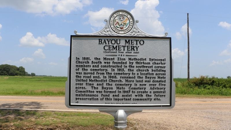
Thirteen charter members founded Mount Zion Methodist Episcopal Church South in 1881 and constructed a small, wooden church building in the southwest corner of the Bayou Meto Cemetery. The structure contained handmade pews, oil lamps, and
a wood . . . — — Map (db m178026) HM
Named for resident William Finley Crockett, son of frontiersman Davy Crockett, this community was once a flourishing river port during the second half of the 19th century and into the early years of the 20th century. Steamboats loaded with cotton, . . . — — Map (db m201389) HM
The Mountain Home Cemetery began with the burial of an 11-month-old child, Willie Russell, in 1857. Willie was the son of County Judge John S. Russell. The lot was owned by Orrin L. Dodd, known as the “Father of Mountain Home,” before it was . . . — — Map (db m243005) HM
This commercial historic district was added to the National Register of Historic Places on June 15, 2010
as a representative collection of early to mid-20th century vernacular architecture, Centered on the Baxter County Courthouse, which was . . . — — Map (db m170753) HM
Jacob Wolf was a merchant, builder of log structures,
carpenter, and blacksmith. He was elected a
representative to Arkansas Territory's General
Assembly in 1826. The two-story dogtrot structure
constructed by Wolf in 1829 served as Izard . . . — — Map (db m170758) HM
The Oaks
Home of Congressman Samuel W. Peel
In 1875, Samuel Peel built a two-story home on the outskirts of Bentonville that he named “The Oaks.” The house is an excellent example of the Italianate style that was popular in the South . . . — — Map (db m276707) HM
The Arkansas & Oklahoma Railroad, owned by John Bayless and William Felker, was the train route west from Bentonville to Gravette from 1898 to 1900. Besides transporting passengers, this route played a major role in the growth of the Ozark fruit . . . — — Map (db m266017) HM
Dr. W.D. and Ida Feaster were notable African American civic leaders and educators in Arkadelphia in the 20th century. Originally from South Carolina, they were educated at colleges and universities on the East Coast. In 1906 they moved to . . . — — Map (db m253950) HM
The man known to the world as Johnny Cash was
born near here, in the home of his grandparents,
John Lewis and Rosanna Hurst Rivers, on
February 26, 1932. The family doctor was not
able to arrive in time for his birth, so a midwife,
Mrs. Grace . . . — — Map (db m170307) HM
Johnny Cash moved with his parents and siblings
from Kingsland to Dyess, Arkansas in 1935 when he
was three years old. Johnny would often return to
the Kingsland area to visit or stay the night with
his Cash and Rivers relatives during his youth . . . — — Map (db m170310) HM
Paul William Bryant was born on September 11, 1913, and spent his early years here in a home in Moro Bottom. He was one of twelve children born to Monroe and Ida Bryant. As a young teenager, Paul earned the nickname “Bear” by entering a carnival . . . — — Map (db m257831) HM
The New Edinburg Commercial Historic District,
located along the north and south sides of Highway 8,
was added to the National Register of Historic Places
on September 4, 2001 as a representative collection
of Craftsman style architecture . . . — — Map (db m170749) HM
Cash Family Reunions
Johnny Cash often returned to Rison with his siblings
and father, Ray Cash, to attend annual family reunions
held at the old American Legion Hut, which formerly
stood across from the courthouse on Sycamore Street.
At . . . — — Map (db m185709) HM
Johnny Cash Day in Arkansas
On March 20, 1976, Johnny Cash Day in Arkansas
was declared by proclamation issued by then-
Governor David Pryor. The festivities started in
Kingsland where Johnny and his family boarded a
special train, the . . . — — Map (db m170305) HM
On this site stood the Blessed Sacrament Catholic Church, consecrated October 17, 1933, by the Reverend John Morris, Bishop of Little Rock. This Romanesque Revival building was built with the help of parishioners to replace the previous church, . . . — — Map (db m206942) HM
On December 27, 1862, Union columns totaling 8,000 troops and thirty pieces of artillery under the command of Generals James G. Blunt and F.J. Herron marched south from Cane Hill and Prairie Grove to conduct a raid on Rebel-held Van Buren. At . . . — — Map (db m250681) HM
Lines Cemetery is the last visible remnant of early communities that existed in the vicinity of Gold Creek south of Conway in the late 19th century. Beginning in the 1870s, families moved into this sparsely populated district; the earliest . . . — — Map (db m290933) HM
On July 27, 1954, the Charleston School Board unanimously voted to integrate all grade levels of its public school system, becoming the first in the South to do so. The Board's decision was in response to the May 17, 1954 United States Supreme . . . — — Map (db m198421) HM
Military Road
The Military Road, following part of the route of the old Southwest Trail, passed through the heart of Hot Spring County and the Midway community. Now known as Midway Road, the primitive pathway served as a major thoroughfare . . . — — Map (db m178623) HM
Elisha Baxter (1827-1899), 10th Governor of Arkansas, was born in Rutherford County, North Carolina. He came to Batesville in 1852, opened a mercantile business and was elected mayor in 1853. Baxter served two terms as state representative . . . — — Map (db m221210) HM
Established in 1855, the Independence County poor farm provided those in need with a place to live, medical care, and the opportunity to grow their own food in the garden patch. These houses were the community’s way of providing care to the poor . . . — — Map (db m226571) HM
In 1835, the Hopewell Cumberland Presbyterian Church was established in a one-room log structure adjacent to the Hopewell cemetery. A community arose with many businesses including blacksmith shops, general stores, gristmill, cotton gin, barber . . . — — Map (db m206934) HM
Land for the Old Baptist Church building and the
adjacent Yeager Cemetery was deeded by Daniel
Yeager in 1897 to the Polk Bayou congregation of
Primitive Baptists for one dollar. The congregation
built a church at this location, yet after a few . . . — — Map (db m170366) HM
After the United States of America was drawn into World War II, the U.S. Army Air Forces urgently needed pilots. On April 15, 1942, its Site Selection Board recommended this location for a Basic Flying School, one of only 26 nationwide. The War . . . — — Map (db m286433) HM
(side 1)
The first tracts of South Bend Plantation, originally known as the Jordan Place, were purchased in 1840 by Dr. John Augustus Jordan. In 1852, Jordan and Irene Johnson married and built a stately southern Georgian mansion on the . . . — — Map (db m285063) HM
The Logan County Jail, built in 1903, served as an active jail until 1971, before becoming the Logan County Museum in 1972. Contractor and local attorney Anthony Hall combined jailer’s living quarters, incarceration cells, and administrative space . . . — — Map (db m311701) HM
During segregation in the twentieth century, Ash Street was the social and commercial heart of the Black community of Blytheville. On Saturdays, when sharecropper families would dress up and come to town, Ash could be so crowded that people would . . . — — Map (db m213826) HM
The Mt. Union Church of Christ and Cemetery trace
their origins to Nathan Cathey's arrival in 1882.
This former slave, Civil War veteran, and church
elder started one of the early independent African
American Church of Christ congregations in . . . — — Map (db m304906) HM
The Ephesus Cemetery, listed in the National Register of Historic Places on January 22, 2009, was established for the members and families of the Ephesus Primitive Baptist Church. Thirteen years before the platting of the railroad town of Emmet, ten . . . — — Map (db m184499) HM
The first church in Prescott was a Cumberland Presbyterian congregation organized in April 1874, six months before the city was incorporated. A congregation of the Presbyterian Church in the United States (PCUS) followed in 1879, and land for its . . . — — Map (db m221261) HM
Thomas Chipman McRae, born in Mount Holly (Union County), Arkansas, became a courier for the Confederate Army at age twelve, following his father's early death. He attended area schools and later graduated from Washington & Lee University law . . . — — Map (db m184504) HM
Ouachita County Training School (OCTS) was formed in 1949 when the Cotton Belt Rosenwald School, which had operated at this site since 1929, consolidated with two other area Rosenwald Schools. OCTS included a high school and offered many courses, . . . — — Map (db m286438) HM
Legendary singer and guitarist Glen Campbell was born in Billstown, Arkansas on April 22, 1936. He died in Nashville, Tennessee on August 8, 2017 after a courageous battle with Alzheimer's disease. Campbell brought country music to the mainstream as . . . — — Map (db m184564) HM
Potts Inn John Kirkbride Potts (1803-1879) was born in Pennsylvania and moved to Arkansas in the 1820s. In 1828 he settled by Galla Creek, eventually acquiring 650 acres of land. Potts went to California in the Gold Rush of 1849: he failed to . . . — — Map (db m225451) HM
The Central Arkansas & Eastern (CA&E) began in 1901 as a short line railroad for transporting timber products from Lonoke County to the Little Rock market. It expanded to Stuttgart and Hazen in 1911 as rice became a major export of the Grand . . . — — Map (db m294945) HM
Dr. William Cogswell Hazen, an early pioneer of what is now Prairie County, was born in 1806 in Charlottesville, Virginia. He spent his early adulthood in Covington, Tennessee as a plantation owner and physician before moving with his family and . . . — — Map (db m294943) HM
Hazen began in the early 1870s as a small refueling station at William Hazen’s place on Arkansas’s oldest railroad line, the Memphis & Little Rock. The settlement grew as the station became a regional transportation hub for agricultural goods, like . . . — — Map (db m294944) HM
John Kocourek was born in 1862 in Bohemia. He immigrated to Chicago in 1881, where he married and had three children. Around 1890, the family moved to Hazen, Arkansas, where Kocourek established himself as a land agent. Through his promotional . . . — — Map (db m294941) HM
Frank Moore, a WWI veteran buried at Little Rock National Cemetery in 1932, moved to Phillips County, Arkansas, after being honorably discharged in December of 1918 from service as a private in the 162nd Depot Brigade, There he worked on a farm and . . . — — Map (db m210364) HM
During the nineteenth century, waves of German-speaking immigrants settled in Pulaski County. Establishing themselves here as early as 1833, these families had a significant impact on the development of the area through their work as farmers, . . . — — Map (db m220389) HM
Charles Harrison Mason, founder of the Church of God in Christ (COGIC), was born in the mid-1860s on a farm in Shelby County, Tennessee. His parents, Jeremiah and Eliza Mason, later moved the family to Plumerville, Arkansas where Mason was . . . — — Map (db m206947) HM
To address a lack of public recreational facilities, the City of Little Rock began developing Fair Park in 1924. In addition to a zoo, amusement park, and baseball field, the park included Little Rock’s first municipal golf course. This 90-acre, . . . — — Map (db m230803) HM
U.S. Colored Troops in Arkansas in the Civil War.
The U.S. Army began recruiting Black soldiers in 1863, and 5,526 men served in eight infantry regiments and two artillery batteries raised in the state. These were the 1st, 2nd, 3rd, 4th, . . . — — Map (db m266962) HM WM
Near this site on September 18-19, 1980, an accidental explosion destroyed Missile Complex 374-7, which housed an Air Force Titan II intercontinental ballistic missile (ICBM). At 103 feet tall and with a 9-megaton nuclear warhead, the Titan II was . . . — — Map (db m311547) HM
The Hinkle cabin was built in 1873 by John Weaver and Lucy Kenner Hinkle, who homesteaded the surrounding 154 acres. They married in 1859 in Blount County, Alabama, where seven children were born: William, Louisa Ann (“Eliza”), Mary Jane, Frances . . . — — Map (db m286892) HM
Archibald Yell was Arkansas’s first congressman and its second governor. Likely born in Tennessee in the late 1790s, Yell received limited formal education but a sound instruction in law, which became his calling. Yell’s close friendship with . . . — — Map (db m234889) HM
Added to the National Register of Historic Places in 1997, Evergreen is the first public cemetery in Fayetteville and final resting place of city, state and national leaders. The first burials began in the 1840s as the private family cemetery of . . . — — Map (db m206939) HM
This historic district comprises three buildings and represents some of the last links to Winslow’s heyday as a resort town. One building dates to 1929; two older ones burned in 1935 and were rebuilt ca. 1938. Maud Dunlap Duncan ran a drugstore . . . — — Map (db m248615) HM
The Colony. After the Civil War, African Americans from across the former Confederacy settled here, in a farming community called The Colony. Many owned their own farms and others were sharecroppers. The community established the Mount Olive . . . — — Map (db m229615) HM
At this location in August 1902, the Woodruff County Courthouse in Cotton Plant was completed. Built by C.W. Clark and designed by noted Arkansas architect Charles L. Thompson, the courthouse was erected to serve the southern district of the county. . . . — — Map (db m141555) HM
With its rugged, scenic beauty and views of the Arkansas River Valley, Mount Nebo has been a popular recreational destination since the late 19th century. In 1928, the 1,350-foot landmark became Arkansas’s second state park. On April 5, 1933, . . . — — Map (db m206938) HM