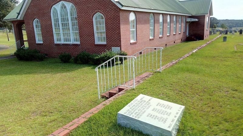
To the memory of the African slaves who lived, worked, worshipped and died here at April, 1857. These 23 were baptized members of the Pea River Presbyterian Church
Moses · Dilley · Hanner
Mary · Calvin · Sarah
Henry · Anakey · Hannah . . . — — Map (db m187391) HM
This cemetery is the final resting place for many early pioneers who settled this area of Alabama. More than six generations of families from the surrounding communities including county elected officials, mayors of both Louisville and Clio, . . . — — Map (db m187390) HM
Near here is old Spring Hill, the site of one of the polling places for the November 3, 1874 local, state and national elections. Elias M. Keils, scalawag and judge of the Circuit Court of Eufaula, was United States Supervisor at the Spring Hill . . . — — Map (db m60894) HM
The Southwestern Railroad of Georgia was the first rail line to connect with Eufaula when the railroad bridge between Georgetown, Georgia and Eufaula was completed in late 1865. In 1867 the Vicksburg & Brunswick Railroad Company was formed to build . . . — — Map (db m48624) HM
The McDowell-Pappas House served as the home of Charles S. McDowell Jr. during his years in local and state politics. McDowell was born Oct 17,1871 in Eufaula and was educated in local schools and the University of Alabama. He served as mayor of . . . — — Map (db m190134) HM
The Sparks-Irby House was the home of Governor Chauncey Sparks and his sister, Mrs.Louise Sparks Flewellen. Sparks was born in Barbour County on Oct 8,1884. He served in the Alabama House of Representatives from 1919-1923 and again in 1931-1939. . . . — — Map (db m190137) HM
"Chief Eufaula," the man often referred to in the historical record as "Yoholo Micco," was a Creek chieftain from the Upper Creek town of Eufaula. Born in the late 1700s, he fought alongside allied Creeks with United States forces against his Red . . . — — Map (db m101427) HM
A primary factor in the eventual expulsion of the Creeks from their ancestral homeland was the fact that their territory was some of the best suited in the nation for the production of cotton. Containing enormous tracts of productive soils, a long . . . — — Map (db m101658) HM
Cowikee Cotton Mills, which operated on this site for over 100 years, was for decades Eufaula’s largest employer. The mill began in 1888 as the Eufaula Cotton Mill. In 1909 the Comer family purchased the business and renamed it Cowikee Cotton Mills. . . . — — Map (db m89606) HM
At the dawn of the recorded history of this land, the Creek Indians owned it. Before the men who built the great houses and the men who made the laws settled this area, the United States of America ceded this land to the Creek Indians for “As . . . — — Map (db m89608) HM
Lower Creek village of the Eufaula Indians antedating 1733. Early white settlers began moving into the village called Yufala in 1823. Irwinton chartered 1832, and renamed Eufaula in 1843.
Hub of a prosperous plantation region with thriving . . . — — Map (db m164055) HM
The origins of this church date back to 1834 when Methodists, under the leadership of Jesse Burch and others, met to worship and formed a Sunday School. A frame Greek Revival edifice, at the corner of Livingston and Barbour Streets, was completed in . . . — — Map (db m75188) HM
This stretch of road between Eufaula and the Bullock County line was reconstructed thro the initiative and assistance of Edward Trippe Comer, of Savannah, GA. Its perpetual upkeep is insured by a fund of $100,000.00 set up in trust by him in 1919. . . . — — Map (db m163247) HM
Built between 1856 and 1860 by Edward Brown Young and his wife, Ann Fendall Beall, this was one of the first of the great Italianate style homes constructed in Eufaula. It later became the home of the builders’ daughter, Anna Beall Young, and her . . . — — Map (db m33759) HM
Irwinton Baptist Church was constituted on June 24, 1837. The name of the town changed to Eufaula in 1843, and consequently the name of the church became Eufaula Baptist Church. The church assumed its third name in 1869 when it was changed to First . . . — — Map (db m162277) HM
In 1836 sixteen Eufaula Presbyterians met in a room above William McKenzie’s store to hold worship services. By 1838 the congregation had built their first sanctuary dedicated to worship on the southeast corner of Forsyth Ave. and Union Street. . . . — — Map (db m60560) HM
This road marks the entrance into Eufaula of Federal Troops on April 29, 1865. Lee had surrendered at Appomattox, Virginia on April 9. General Benjamin H. Grierson was advancing with four thousand cavalry from Mobile and was then about at . . . — — Map (db m82872) HM
Constructed During Administration of Governor George Corley Wallace
Dedicated to the six Distinguished Barbour Countians who served Alabama as Governor
John Gill Shorter 1861-63
William Dorsey Jelks 1901-07
Braxton . . . — — Map (db m190110)
Built by John Hart about 1850, the Hart House is recognized as an outstanding example of pure Greek Revival architecture. Hart (c. 1805-1863) moved from New Hampshire and became a prominent merchant and farmer. When constructed, the house was on the . . . — — Map (db m48376) HM
Side 1
Fairview contains a diverse collection of statuary, grave emblems and monuments amid a picturesque park-like setting. Many monuments are attributed
to the Tansey family who owned a monument company in Eufaula and operated their marble . . . — — Map (db m173638) HM
Interred on this gently sloping hillside are the remains of many of Eufaula’s early black citizens. Their names are known only to God because the wooden grave markers which located the burials have long since vanished. This burying ground was used . . . — — Map (db m27987) HM
T.V. McCoo High School
In 1957, Eufaula citizens supported a bond issue that included, among other education projects, construction funds to relocate and build a new Van Buren High School facility. Completed in the same year, the campus was . . . — — Map (db m197392) HM
The Second Creek war resulted in the final expulsion of the Creeks from eastern Alabama and paved the way for large-scale American settlement. The town of Irwinton gradually expanded westward from the bluff overlooking the Chattahoochee in the years . . . — — Map (db m101361) HM
The area surrounding Eufaula was once part of a regional Creek population center. Towns of note in the region included Sawokli (also known as Sabacola) and the town of Eufaula for which the modern city is named. Trails linked these closely-connected . . . — — Map (db m101355) HM
In 1836 long-simmering tensions between Creeks and American settlers erupted into warfare. The Creeks, crowded onto the last portion of their ancestral homeland and witnessing the rampant theft of their lands, had also become subject to harsh laws . . . — — Map (db m101360) HM
On this site stood the St. Julian Hotel where Jefferson Davis and his daughter Winnie, spent the night and where he spoke to the people of Eufaula, March 9, 1886. — — Map (db m185917) HM
A small group of American settlers from Georgia formed a community called Eufaula in this vicinity as early as 1823. The settlement began to grow in importance later in the decade through the influence of prominent local landholder and Creek War . . . — — Map (db m101357) HM
The Tree That Owns Itself
Planned and Dedicated
April 19, 1961
Replacing the Walker Oak
Felled by Wind April 9, 1961
Original Deed Granted by
City of Eufaula
to the
Post Oak Tree
April 8, 1936 . . . — — Map (db m101286) HM
May God Continue To Give Our Nation
"Stout-Hearted" Men Like The Vietnam
Veteran to who this monument is dedicated
General William C. Westmoreland
Commander of U.S. Forces Vietnam Dedicated May 39, 1983
"Nobody In His Right Mind Welcomes . . . — — Map (db m174939) WM
(Front): First known as White Oak Chapel this church was dedicated on October, 18, 1859 by Rev. Issac I. Tatum of the Alabama Conference Methodist Episcopal Church South. The Society was organized by Rev. John J. Cassady who served as pastor . . . — — Map (db m163401) HM
This is the site of the Shorter–Treadwell–Jelks Home which was the family residence of Governor John Gill Shorter and later William Dorsey Jelks. The house was demolished in late 1963. Jelks was born in Warrior Stand, Alabama on Nov. 7, 1855. In . . . — — Map (db m186506) HM
William Thomas "Tom" Mann
1932-2005
Family man, entrepreneur and bass angler legend, Tom Mann, achieved fame as a fishing lure designer/manufacturer and helped put Lake Eufaula on the map with his popular television shows. With an . . . — — Map (db m113682) HM
To Those Who Made The Supreme Sacrifice
1917 — World War — 1918
John Asbury Boswell
Robert W. Brannon-Hinton W. Holleman
Porter R. Doughtie-Daniel T. Tully
Lest We Forget. — — Map (db m101350) WM
Cast in 1889 to commemorate the Town of Louisville Fire Department, this fire bell was located on top of the well house near the ball field. The ringing of the bell alerted volunteers of a fire.
This bell was re-installed and dedicated at . . . — — Map (db m190965) HM
One of the oldest towns in southeast Alabama was settled in 1817 by Daniel Lewis who established a trading post and named the community “Louisville” after the first capital of Georgia, his hometown. By 1820 four stores, a Methodist . . . — — Map (db m60768) HM
Louisville is one of the oldest communities in southeastern Alabama. Locąted within territory ceded by the Creeks in the Treaty of Fort Jackson (1814) ending the Creek War, the area was first settled by Americans as early as 1817. Many of its . . . — — Map (db m111642) HM
The battles of Hobdy's Bridge and Pea River were the result of the desperate attempt of Creeks to avoid removal to the West by fleeing to Florida along trails bordering the Pea and Conecuh Rivers. The battles marked the last large-scale . . . — — Map (db m111627) HM
Near this site stood the old Pike County court house which was the county seat of Pike from 1822 to 1827. It also served as the temporary county seat of the newly created Barbour County in 1833, until Clayton was selected. Louisville was settled . . . — — Map (db m60674) HM
The Second Creek War began in May of 1836 when a portion of area Creeks, angry at their treatment in the wake of the Treaty of Cusseta and in desperate circumstances, struck out against American settlements. A series of small battles occurred . . . — — Map (db m111618) HM
Robert Martin bought 1200 acres of land from the U.S. Government. He set aside eight acres to build a church for the community. This building has been used almost constantly since 1837. At times it was a Methodist Church; at times Baptist. It is now . . . — — Map (db m164709) HM
Braxton Bragg Comer was born on Mov 7, 1848 at Old Springhill in Barbour County. He attended the University of Alabama and the University of Georgia before graduating in 1869 from Emory and Henry College in Virginia. Comer eventually relocated to . . . — — Map (db m207440) HM
Fort Browder
Approximately one mile south-southwest of here stood Fort Browder, a small wooden fortification built in 1836 for protection in the last war with the Creek Indians and named for Isham Browder, a prominent local planter. In 1861, . . . — — Map (db m188679) HM
Fort Browder
Approximately one mile south-southwest of here stood Fort Browder, a small wooden fortification built in 1836 for protection in the last war with the Creek Indians and named for Isham Browder, a prominent local planter. In 1861, . . . — — Map (db m208018) HM
Constructed in the 1840s and constituted in 1852, Ramah Baptist
Church is in the community formerly known as both Ramah and
Vaughn. Records show that the land for both the church and
cemetery was given by Solomon G. and Francis T. Burke in . . . — — Map (db m158553) HM
This Greek Revival church was built in 1841 by John Fletcher Comer with lumber from his mill. The building originally had a slave balcony and exterior stairway which were removed c. 1890. At the same time, the pulpit was moved from between the two . . . — — Map (db m188268) HM
The City of Brent was founded in 1898 in the southern portion of Bibb County along the Gulf, Mobile and Ohio Rail line. The town was named after Mr. Brent H. Armstrong, a surveyor for the railroad. Brent was later incorporated in 1913. The . . . — — Map (db m217202) HM
Absalom Pratt built this house 8 miles west of here circa 1835 though a section was constructed earlier. It was moved to this site in 1994 by the Cahaba Trace Commission, restored by the Alabama Historic Ironworks Commission, 1997-98, and dedicated . . . — — Map (db m37078) HM
The Bibb County Iron Company under the direction of C. C. Huckabee of Newbern, Alabama, constructed a furnace here and poured the first iron in November 1862. Within a year, the Confederate government purchased the works and completed a second and . . . — — Map (db m37090) HM
Wilson Hayes constructed this typical farm house for his wife and six children just south of Six Mile around 1900. After he moved to Oklahoma c. 1915, his daughter Ollie and her husband Levert Rotenberry lived in the home until 1928. Between 1928 . . . — — Map (db m37136) HM
Originally located off Patton Chapel Road in what is today Hoover, Alabama, the Sunshine and Dorothy Morton house was moved to the Brierfield Park in March 2005 by the Morton family and restored over the next two years by restoration specialist . . . — — Map (db m37177) HM
Centreville Cemetery is older than the town of Centreville itself. The earliest known burial is that of Willie Coleman, dated 1822, and Centreville was established in 1823. One half of the cemetery, known as Cooper Cemetery, contains mostly the . . . — — Map (db m156403) HM
Years before 1859, two acres of land were donated for a school by Mr. and Mrs. Good. A two-story wooden structure was built. Among its first teachers were John Alexander, W. J. Peters, R. M. Humphries, and R. H. Pratt. Under Pratt’s leadership the . . . — — Map (db m37054) HM
Incorporated in 1859 though organized earlier and operated continuously through 1897. First trustees were William P. Thomas, Leroy T. McGuire, Ezekiel C. Smith, Simpson W. Hederick and Pulaski Wallace. This noted center of learning in Bibb County . . . — — Map (db m37053) HM
One and a half miles northeast of here, the mining town of Belle Ellen was established by the Bessemer Coal, Iron and Land Company in the fall of 1895 and named for Henry F. DeBardeleben's daughter, Belle, and wife, Ellen. DeBardeleben was a noted . . . — — Map (db m37226) HM
Blocton
Centered around the coke ovens, Blocton, first called Gresham, was the Cahaba Coal Mining Company town founded by Truman H. Aldrich in 1883-84. Other company officers included W. A. Clark of Muscatine, Iowa, and Cornelius Cadle, Jr., . . . — — Map (db m37228) HM
Piper
The town of Piper was established in 1901 a half mile northeast of here by the Little Cahaba Coal Company, named for Oliver Hazzard Perry Piper, a partner of industrialist Henry F. DeBardeleben. Two coal mines were opened in 1901 and . . . — — Map (db m83225) HM
The railway system was an important part of the iron and steel industry and the operation of the Blocton coke ovens. The ovens were constructed with rails on top for the charging car, often called a larry. There were rails between each row of ovens . . . — — Map (db m215680) HM
History of coke ovens
In the park are four rows of the remains of the Cahaba Coal Company's coke ovens. These beehive block ovens were not the earliest coke producing units in the Cahaba Coal Field but may very well have been the largest . . . — — Map (db m215677) HM
West Blocton began as a business and residential community adjoining the Cahaba Coal Mining Company's town of Blocton in 1883-84. West Blocton incorporated in 1901. Eugene D. Reynolds was the first mayor, 1901-1904, followed by Dr. L.E. Peacock, . . . — — Map (db m72283) HM
Coke ovens, such as the ones you see in the park, are used to convert coal into coke, a cleaner burning fuel that produces little smoke. Construction here started in the late 1880's, with 140 ovens producing coke by 1889. The end buttresses that . . . — — Map (db m215681) HM
Woodstock was first settled in the 1820’s with a formal land grant to William Houston on Feb. 27, 1826. The settlement was established along the old Tuscaloosa to Huntsville Stage Coach Line. Woodstock got its name when Dr. J.U. Ray named it after . . . — — Map (db m63697) HM
Nathan Bedford Forrest attacked Col. Streight’s column as it crossed Locust’s swift waters, causing the Federals to make tremendous exertions to complete the movement, contributing thereby to Streight’s eventual surrender of his entire command to . . . — — Map (db m28320) HM
1820-1889 seat of Blount County, a county older than the State.
Named for Tennessee Governor W. G. Blount who sent Andrew Jackson to aid Alabama settlers in Creek Indian War, 1812-1814.
Indian Chief Bear Meat lived here at crossing of . . . — — Map (db m156445) HM
1813: Colonel John Coffee and 800 Tennessee Volunteers see Bear Meat Cabin Cherokee Settlement near Blountsville
1816: Town settles around square
1820: Newly named Blountsville becomes county seat
1827: Town incorporated with Trustee System . . . — — Map (db m49176) HM
First minister assigned to Alabama Territory by Tennessee Conference. Preached first sermon two blocks west at Bear Meat Cabin (present Blountsville) April 18, 1818. He later organized churches in Shelby, St. Clair, Jefferson, Tuscaloosa and Cotaco . . . — — Map (db m27991) HM
Three prowling Union soldiers invaded home of sister-in-law of Celia and Winnie Mae Murphree taking food, drink; killing two colts.
When soldiers fell asleep, these two young girls took rifles, marched soldiers to headquarters of General . . . — — Map (db m83226) HM
Gen. N.B. Forrest (CSA) captured wagon train and supplies of Col. Streight's raiders (USA).
Forrest continued his relentless pursuit eastward toward final capture of Streight. — — Map (db m24363) HM
Four school sites have been located in this community known as Morton’s Center, Hew Hope, and Poplar Springs now Holly Springs. The first at Morton’s Center was taught in 1882 by George W. Burttram. The first school at New Hope was taught by . . . — — Map (db m145410) HM
Member Constitutional Convention 1819
First Senator of Blount County
Brigadier General,
Alabama Militia
County road and court
systems organized
at his house 1820. — — Map (db m32484) HM
While traveling south with his troops, General Andrew Jackson camped at the fork of the river in 1813. General Jackson carved his name in a locust tree naming this area Locust Fork. In 1817, the Hanby family came from Virginia and settled in this . . . — — Map (db m50125) HM
Planter, trader, historian, geologist, surveyor. Gathered authentic data from early settlers and Indians for his history of Blount County published in 1855. Made original survey of Blount County. — — Map (db m50123) HM
Antioch (an'~te~ok') was an ancient Biblical city and a chief center of early Christianity. Today, many churches and cemeteries throughout the United States use the name. Once called Glover's Graveyard, the earliest recorded burial is 1794. Antioch . . . — — Map (db m128071) HM
William M. Bailey (born 1859 in Cherokee Co.; died 1909 in Blount Co.) settled 40 acres on what became Co. Rd 36 to the west and New Home Church Rd to the east in 1893. He brought three small sons from Cherokee Co. after the death of his first wife . . . — — Map (db m42599) HM
Created Feb. 7, 1818 by Alabama Territorial Legislature from lands ceded by the Creek Indian Nation. Named for the Tennessee Governor W. G. Blount, who sent militia under Andrew Jackson to punish the Creeks for Fort Mims massacre. Jackson fought and . . . — — Map (db m24353) HM
John Hanby came in 1817 and found a rich seam of brown iron ore. Named Champion in 1882 when Henry DeBardeleben and James Sloss bought land and brought L&N Railroad causing county seat to be moved from Blountsville to Oneonta in 1889. Most ore was . . . — — Map (db m28362) HM
Starting in 1889, the Louisville and Nashville Railroad, also known as the Birmingham Mineral Railroad, began railroad freight and passenger
service to Oneonta with the completion of the rail line from Boyles Railroad Yard near Birmingham to the . . . — — Map (db m38894) HM
The origin and development of Oneonta was due to the coming of the Birmingham Mineral Railroad, a part of the Louisville & Nashville Railroad. Because of the presence of iron ore, limestone and coal in the area, there was always a great potential . . . — — Map (db m156406) HM
In 1864, traveling in an ox cart, Dr. Robert M. Moore left his family in Walton County, Georgia, and journeyed to Blount County, Alabama. Finding fertile land, he returned to Walton County and persuaded his wife to move to Blount County with him. In . . . — — Map (db m49251) HM
The town of Aberfoil was incorporated January 26, 1839, in then Macon County, with the first election for councilors conducted and managed by Lewis Stoudenmire, Charles G. Lynch, Thomas Scott, David Hudson, and A. J. and E. A. Jackson. Aberfoil was . . . — — Map (db m61027) HM
Side 1
In 1890, Reverend C. H. Thornton donated 10 acres of land where he
organized a church and the first public school for African Americans
in the Aberfoil community. The first school structure was a one
room log cabin. Rev. . . . — — Map (db m153582) HM
Samuel Sellers (1788-1857) of North Carolina arrived with his large family at Three Notch Road on January 29, 1835. Here, in what was then the Missouri Beat, Pike County, the first post office in the area was established, 2.5 miles west of . . . — — Map (db m61061) HM
Side 1
Built by U.S. Army engineers over the summer of 1824, Three Notch Road has served as Bullock County’s major transportation route throughout its history. It was constructed to facilitate military communication between Pensacola . . . — — Map (db m89638) HM
Lacking an established church nearby, pioneer families of the Fitzpatrick community into the mid-19th century took turns hosting worship services in their homes on Sunday mornings. "The Church of the Seven Sisters" was established in 1858 by seven . . . — — Map (db m67158) HM
Drill Ground of the Midway Guards 1860, later Company B 15th Alabama C.S.A. ordered to Richmond. Second Company 1861 assigned to Company C 45th Alabama C.S.A. ordered to Army of Tennessee. These and many later volunteers met the enemy in . . . — — Map (db m89636) HM
The Macedonia Baptist Church, located between the communities of Midway and Mt. Coney, was constructed by freedmen after the American Civil War, replacing the brush arbors used by the area’s antebellum slaves as sites for religious worship. Four . . . — — Map (db m60947) HM
Midway, a part of Barbour County in the mid-19th century, was also known as Five Points, a small community of a handful of dwellings, two stores, and a Methodist church of logs. In this Methodist church, Joel Willis, J.M. Thornton, Robert G. Hall, . . . — — Map (db m60908) HM
Margaret Elizabeth Merritt of Midway sold two acres for $5 to the state of Alabama in 1921 as a site for an elementary school for African-American children. Built in 1922 with matching Rosenwald funds, the Midway Colored Public School featured oak . . . — — Map (db m60910) HM
St. James Christian Methodist Episcopal Church founded by Reverend Jack McMillan, a former slave of Midway’s Daniel McMillan. Initially meeting outdoors under a brush arbor, ex-slaves and their children constructed a wood-frame church building soon . . . — — Map (db m60909) HM
Pioneer Samuel Feagin Sr. settled the Village of Midway in 1836. He came from Jones County, Georgia and established his residence at what is still called “The Old Feagin Place.” Samuel purchased a large acreage of land and sold it to . . . — — Map (db m61854) HM
This community, settled during the mid-1830s, was first called Fulford’s Cross Roads, then Missouri Cross Roads when a post office was established here in 1846. The name Perote, adopted in 1850 was suggested by veterans returning from the Mexican . . . — — Map (db m83256) HM
Side 1
Built by U.S. Army engineers over the summer of 1824, Three Notch Road has served as Bullock County’s major transportation route throughout its history. It was constructed to facilitate military communication between Pensacola . . . — — Map (db m89637) HM
3969 entries matched your criteria. Entries 201 through 300 are listed above. ⊲ Previous 100 — Next 100 ⊳