By Cosmos Mariner, July 27, 2014
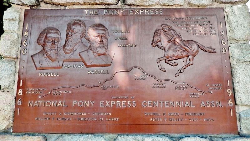
National Pony Express Centennial Association Plaque (mounted above marker )
GEOGRAPHIC SORT Title Sort Marker Number Sort Marker Number Sort N Marker Number Sort T Publication Order Sort Publication Order Sort A Erected Year Sort Most Viewed Sort Most Recent-Interest Sort Most Recently Changed Sort SEE FAQ #33 FOR DESCRIPTIONS
On North Carson Street (Lincoln Highway) (Business U.S. 395) north of West Robinson Street, on the left when traveling north.
Near South Carson Street (U.S. 395/50).
On Spooner Drive near Windridge Drive, on the right when traveling west.
On South Carson Street (Business U.S. 395), on the right when traveling south.
Near South Carson Street (U.S. 395/50) near East Musser Street.
On North Stewart Street, on the left when traveling south.
On East 3rd Street just east of South Stewart Street, on the right when traveling west.
On Lincoln Highway (U.S. 50).
On East Musser Street at North Pratt Avenue, on the right when traveling east on East Musser Street.
Near Bigelow Drive near Snyder Avenue.
Near North Carson Street (Lincoln Highway) (Business U.S. 395) at East Caroline Street, on the left when traveling north.
On West Appion Way at Snyder Avenue, on the right when traveling west on West Appion Way.
On U.S. 50 at Akron Way, on the right when traveling east on U.S. 50.
Near Brick Road near Morgan Mill Road.
On North Carson Street at East Telegraph Street, on the right when traveling north on North Carson Street.
Paid Advertisement
On South Carson Street (Business U.S. 395) just south of West 2nd Street, on the right when traveling south.
On South Carson Street (U.S. 395/50), on the right when traveling south.
Near South Carson Street (U.S. 395/50).
On East Musser Street at North Plaza Street on East Musser Street.
On Kings Canyon Road, 0.1 miles south of Cooper Springs Court, on the right when traveling south.
Near Seely Loop near North Saliman Road, on the left.
Near U.S. 50, on the right when traveling west.
Near South Carson Street (U.S. 395/50).
On U.S. 395 Alterate (Alternate U.S. 395) at Hobart Road, on the right when traveling south on U.S. 395 Alterate.
On North Carson Street (Lincoln Highway) (Business U.S. 395) at West Robinson Street, on the left when traveling north on North Carson Street (Lincoln Highway).
Near South Carson Street (Business U.S. 395) at Fairview Drive, on the right when traveling south.
On North Division Street.
On North Roop Street, 0.2 miles south of East William Street.
On North Carson Street (Lincoln Highway) (Business U.S. 395) north of West Robinson Street, on the left when traveling north.
On South Stewart Street at East 7th Street, on the right when traveling south on South Stewart Street.
Near Seely Loop near North Saliman Road, on the left.
Paid Advertisement
Near South Carson Street (U.S. 395/50) near East Musser Street.
On West King Street at Nevada Street, on the right when traveling west on West King Street.
On North Curry Street, on the right when traveling north.
On North Carson Street at West Second Street when traveling north on North Carson Street.
On West Fifth Street at Terrace Street, on the right when traveling west on West Fifth Street.
On North Carson Street at East Telegraph Street, on the right when traveling north on North Carson Street.
On North Curry Street near West King Street, on the right when traveling south.
On West 3rd Street at Carson Street (Business U.S. 395), on the right when traveling west on West 3rd Street.
On North Division Street near West Telegraph Street, on the right when traveling south.
Near East 2nd Street just west of South Stewart Street, on the right when traveling west.
On Snyder Avenue near Clear Creek Drive, on the right when traveling south.
On North Minnesota Street at West King Street, on the right when traveling south on North Minnesota Street.
On North Carson Street (Business U.S. 395) just south of Corbett Street, on the right when traveling north.
On Mountain Street at West Robinson Street, on the left when traveling north on Mountain Street.
On North Carson Street (U.S. 395), on the right when traveling south.
On West Robinson Street near North Carson Street, on the right when traveling west.
Paid Advertisement
On North Plaza Street at East Washington Street on North Plaza Street.
Near South Carson Street (Business U.S. 395) at West 2nd Street, on the right when traveling north.
Near East Musser Street near North Fall Street when traveling south.
On Carson Street at Washington Street, on the right when traveling north on Carson Street.
On North Carson Street, on the right when traveling north.
Near East Musser Street at North Fall Street when traveling south.
On U.S. 50, 23 miles north of Nevada Route 722, on the right when traveling north.
Near U.S. 50, 22 miles west of Nevada Route 722, on the right when traveling west.
Near U.S. 50 at milepost 30.7, on the left when traveling east.
On Pioneer Way, 0.5 miles south of U.S. 50, on the right when traveling south.
On Lincoln Highway (U.S. 50) 0.1 miles west of Trento Lane, on the right when traveling east.
On U.S. 50, on the right when traveling west.
On West Williams Avenue at Lincoln Highway (U.S. 50), on the right when traveling west on West Williams Avenue.
On West Williams Avenue near Lincoln Highway (U.S. 50).
Near U.S. 50 at milepost 30.7, on the left when traveling east.
On U.S. 50, 5 miles east of Nevada Route 839, on the right when traveling east.
Paid Advertisement
On Earthquake Fault Road, 0.3 miles south of U.S. 50, on the right when traveling south.
On U.S. 50 at milepost 30.7, on the right when traveling west.
Near U.S. 50 at milepost 30.7, on the left when traveling east.
On Old Carson Highway north of Nevada Route 50, on the left when traveling north.
Near U.S. 50 at milepost 30.7, on the left when traveling east.
Near Unnamed Road, 0.6 miles west of Earthquake Fault Road.
On East Park Street, on the right when traveling north.
On North Maine Street (U.S. 95) just south of East A Street, on the right when traveling north.
Near Salt Wells Road, 6.5 miles south of U.S. 50.
On Reno Highway (U.S. 50) near Pioneer Way, on the right when traveling east.
Near U.S. 50 at milepost 30.7, on the left when traveling east.
On U.S. 50, 11 miles north of Nevada Route 722, on the left when traveling north.
On U.S. 50 at milepost 46.5, on the right when traveling west.
Near US Highway 50 (U.S. 50).
Near U.S. 50 at milepost 30.7, on the left when traveling east.
Paid Advertisement
Near Lincoln Avenue (U.S. 50) 25 miles east of Maine Street (U.S. 95), on the left when traveling east.
On Lincoln Highway (U.S. 50) near Wildes Road (County Route 118), on the left when traveling east.
Near U.S. 50, 11 miles north of Nevada Route 722, on the right when traveling north.
On U.S. 95, 0.9 miles south of Interstate 80, on the left when traveling south.
On Nevada Route 722 at milepost 4.7, on the right when traveling north.
Near Lincoln Avenue (U.S. 50) 25 miles east of Maine Street (U.S. 95), on the left when traveling east.
On U.S. 50, on the right when traveling east.
On U.S. 50 at milepost 61.5, on the right when traveling west. Reported missing.
On U.S. 50 at California Road, on the right when traveling west on U.S. 50.
Near U.S. 95 at Interstate 80, on the right when traveling south.
Near U.S. 95 at Interstate 80, on the right when traveling south.
Near U.S. 95 at Interstate 80, on the right when traveling south.
Near U.S. 95 at Interstate 80, on the right when traveling south.
On Nevada Route 50 west of Route 361, on the right when traveling west.
Near Nevada Route 361 south of Lincoln Highway (U.S. 50), on the right when traveling south.
On Pahrump Valley Highway (Nevada Route 160 at milepost 17), on the left when traveling west.
Paid Advertisement
Near Charleston Boulevard (Nevada Route 159).
On Village Boulevard at Diamond Street, on the left when traveling east on Village Boulevard.
On Canyon Road, 0.6 miles north of Industrial Road, on the right when traveling north.
On U.S. 93, on the right when traveling west.
On U.S. 93, on the right when traveling west.
965 entries matched your criteria. The first 100 are listed above.
Next 100 ⊳