On West Church Street just west of North Broad Street (State Highway 32), on the right when traveling west.
1702 Builds first church in North Carolina Three Carolina governors buried herein. Joseph Hewes, signer of Declaration of Independence; Dr. Hugh Williamson, signer of U.S. Constitution; James Iredell, Washington's youngest Supreme . . . — — Map (db m224755) HM
Near South Broad Street, 0.1 miles south of East Water Street, on the left when traveling south.
The Sea Trading period brought fame and prosperity to Edenton and famous forefathers who saw promise here, chose to stay and, over time, became among our Nation's Leaders: Samuel Johnston (Age: 20, 1753), appointed to first Continental . . . — — Map (db m224497) HM
Near South Broad Street south of West King Street, on the right when traveling south.
This location in the back garden may well be the site of the original kitchen as outlined above in the Sanborn Five Insurance Map of 1883. An excellent example of a surviving 18th century kitchen is found at Somerset Place, across Albemarle Sound . . . — — Map (db m226115) HM
On West Queen Street (Business U.S. 17) at Dickinson Street, on the right when traveling east on West Queen Street.
The principal town of the Weapemeoc Indians, visited by Ralph Lane and his colonists in 1585-1586, stood near present-day Edenton. — — Map (db m56986) HM
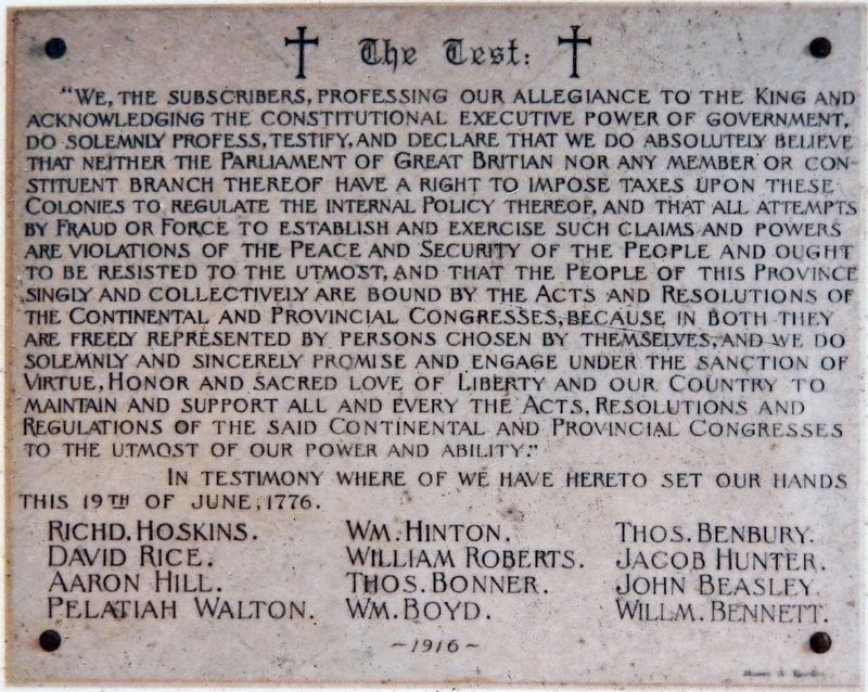
North Carolina. Colonized, 1585-87, by first English settlers in America; Permanently settled C.1650; First To vote readiness for Independence, Apr. 12, 1776
South Carolina. Formed in 1712 from part of Carolina, which was chartered . . . — — Map (db m16820) HM
An early settler to Kings Mountain, William Andrew Mauney built a store on this site circa 1870. When Mr. Mauney moved his business to a location in downtown Kings Mountain, he turned the store ninety degrees and added a two story structure to the . . . — — Map (db m17703) HM
On East 5th Street (Business U.S. 701) at Pireway Road (North Carolina Highway 904), on the right when traveling south on East 5th Street.
Baptist Church est. here in 1840. Community settled in 1850’s. Railroad terminus located, 1886. Incorporated 1805. Charter changed to Tabor City, 1935. Former “Yam Capital” of the World. — — Map (db m862) HM
On State Highway 55 near Belltown & Biddle Roads, on the right when traveling south.
Constructed by Colonel John Barnwell of South Carolina in campaign against the Tuscarora Indians in April, 1712. Remains are 2 mi. N. E. — — Map (db m65699) HM
On Broad Street (U.S. 17) at Craven Street on Broad Street.
A resident of New Bern for fifteen years; born in Prince Edward County, Virginia, about 1740, but came to North Carolina in 1763; member of Colonial Assembly from Halifax Town in 1764 and 1765; from the County of Halifax in 1769, 1770 and 1771; . . . — — Map (db m23831) HM
On Queen Street at Pasteur Street, on the left when traveling east on Queen Street.
The first African-American Presbyterian Church in the Craven County area founded in 1880, ½ block north of here on Pasteur Street destroyed by the “Great Fire of 1922” rebuilt in 1924 at 720 Bern StreetThe Honorable George H. White, First Clerk of . . . — — Map (db m222495) HM
1. Cool Spring
Cool Spring is located on the south bank of Cross Creek, which winds its way through downtown Fayetteville. The spring was the primary soucre of water first for Native Americans and subsequently for the European pioneers. It . . . — — Map (db m31149) HM
On Cool Spring Street at Meeting Street, on the right when traveling south on Cool Spring Street.
The Fayetteville Independent Light Infantry is North Carolina's oldest military unit and the second-oldest militia organization in the U.S.
At the start of the Civil War, after North Carolina seceded, the company enrolled in active service for . . . — — Map (db m31109) HM
On Green Street, on the right when traveling north.
Fayetteville was the focal point for five plank roads, chartered 1849-52. The longest was built to Bethania, 129 miles northwest. — — Map (db m24395) HM
On Hay Street at Pittman Street, on the left when traveling east on Hay Street.
Located one block to the north, on the north side of Maiden Lane, Scotch Spring was owned by two prominent citizens, Robert Cochran and John Hay, and was a major water source for Fayetteville in the late eighteenth century. Throughout the nineteenth . . . — — Map (db m30998) HM
On Ramsey Street (U.S. 401) at East Reeves Bridge Road, on the right when traveling north on Ramsey Street.
One of early Presbyterian ministers in N.C., 1757-1780. Organized Bluff, Barbecue, and Longstreet churches. Grave is 8 mi. east. — — Map (db m42003) HM
On Corolla Village Road at Schoolhouse Lane, on the left when traveling south on Corolla Village Road.
Twiddy & Company began preservation in Corolla Village in 1986. The first effort was the Kill Devil Hills Lifesaving Station built in 1878. Relocation from the original oceanfront site was a requirement of the sale, so the station was moved to . . . — — Map (db m76660) HM
On Schoolhouse lane at Corolla Village Road, on the left when traveling west on Schoolhouse lane.
Restoration began in the fall of 1999, revealing wonderful insights into life in this isolated coastal village.
Upon raising the building to repair rotten sills, workers discovered ship timbers in the foundation that were salvaged from . . . — — Map (db m10434) HM
On Corolla Village Road at Schoolhouse Lane, on the left when traveling south on Corolla Village Road.
Establishing the First Unified Corolla School
The Corolla Schoolhouse was built circa 1890 by residents Sol Sanderlin and Val Twiford and established as the first unified Corolla school in 1905. The County's one-room schoolhouse accepted . . . — — Map (db m76658) HM
The Whalehead Club has always been associated with wealth and leisure pursuits. When Edward Collings Knight Jr. and his wife, Marie-Louise LeBel, built their residence here in the 1920s, they made it as opulent as possible. The estate included the . . . — — Map (db m10687) HM
When Ray T. Adams bought this estate for just $25,000 in 1940, he dreamed of opening a hunt club and selling parcels of land for real estate. He changed the name to the Whalehead Club and invited potential investors, politicians (including Dwight . . . — — Map (db m10688) HM
Architectural drawings suggest that the caretaker's residence dates to the 1920s and was designed to house two families who worked for the Knights. Cleveland lewark, chief hunting guide and superintendent of the property, lived in one side of the . . . — — Map (db m10689) HM
Due to excellent wildfowl hunting conditions in the second half of the 19th century, private hunt clubs owned most of the land on the Currituck Outer Banks. In 1874 a group of wealthy Northeaster industrialists build the Lighthouse Club just south . . . — — Map (db m10690) HM
On Ocean Trail (State Highway 12) at Club Road on Ocean Trail.
After second owner Ray T. Adams died in 1957, the Whalehead Club was used as a summer boy's school, housed a rocket fuel testing facility, and was proposed for resort development. With restoration in mind, Currituck County purchased the club in . . . — — Map (db m10691) HM
On Courthouse Road (State Highway 1242) near Caratoke Highway (State Highway 168), on the right when traveling north.
Thursday the 31st December 1767
"On motion the following Bills were ordered to be read ... A Bill to impower the justices of Currituck County to build a prison pillary and stocks in the said county on the lot were the Court House stands for the . . . — — Map (db m9468) HM
On State Highway 12 at Yucca Street, on the left when traveling north on State Highway 12.
Avon was first called Kinnakeet. The name was changed by the post office in 1883 but locals to this day call themselves Kinnakeeters. The name comes from its first settlers, the Algonquian Indians.
For most of its early existence, Kinnakeet was . . . — — Map (db m190966) HM
On State Highway 12 at Timber Trail, on the left when traveling north on State Highway 12.
Frisco was formerly Trent until the coming of the post office i1898. Hatteras Island’s first inhabitants were the Croatoans. Archaeological evidence proves the Croatoans lived here year-round for more than 12,000 years with a population comparable . . . — — Map (db m190984) HM
Near State Highway 12 near Elizabeth Avenue, on the right when traveling south.
Hatteras Village, settled in the 1780s, with the Pamlico Sound on one side and the Atlantic Ocean on the other, has always relied on its natural resources for its livelihood. Initially its population (primarily shipwreck survivors) depended . . . — — Map (db m191320) HM
Near Fort Raleigh Road, 0.3 miles north of U.S. 64.
In the 1860s - more than two and a half centuries after the disappearance of the 1587 settlers, a new colony was taking shape on Roanoke Island, one that was home to refugees fleeing the bondage of slavery. The island south and west of here became a . . . — — Map (db m233626) HM
Near Fort Raleigh Road, 0.3 miles north of U.S. 64.
Despite dissolving only five years after the first individuals arrived, the Roanoke Freedmen's Colony was one of the first steps in a long struggle for racial equality in the United States. Community members fought for their freedom through . . . — — Map (db m233628) HM
This marker is placed in grateful recognition of the gifts of food, friendship, and assistance with which the native inhabitants greeted the first Europeans to Roanoke Island in 1584.
Presented by
North Carolina Society
National . . . — — Map (db m206285) HM
On North Virginia Dare Avenue (U.S. 64/264) at Russel Twiford Road, on the right when traveling west on North Virginia Dare Avenue.
Agent of the American Colonization Society in Liberia, founded the A. M. E. Zion Churches in Albemarle area. His first church, 1865, near here. — — Map (db m9462) HM
On Freedman's Colony Road near U.S. 64/264, on the right when traveling west. Reported permanently removed.
Thus saith the Lord,
Let my people go.
Exodus 8:1
The bloodbath called the Civil War had begun and would cost the lives of over 600,000 Americans. As the Union armies advanced south, refugee . . . — — Map (db m9669) HM
Near Fort Raleigh Road, 0.4 miles north of U.S. 64, on the left when traveling north.
European expeditions in the late 1500s commonly constructed small defensive structures. Soldiers built these earthworks by digging ditches and the forming walls from the removed soil. Ralph Lane, a fortifications export, led the 1585 English . . . — — Map (db m237880) HM
Near Fort Raleigh Road north of National Park Road when traveling north.
A furnace burned hot as metallurgist Joachim Gans and scientist Thomas Hariot conducted tests on local minerals and plants. Sent by Sir Walter Raleigh in 1585 as part of a larger expedition, these scientists built a workshop on this spot to gain an . . . — — Map (db m237881) HM
Near U.S. 64, 0.2 miles east of the William B. Umstead Memorial Bridge, on the right when traveling east.
Explored in 1584. Site of first English settlements in new world, 1585-1587. Birthplace of Virginia Dare, first child born of English parents in America. — — Map (db m11343) HM
[obverse:]First Light of Freedom Former slaves give thanks by the creek’s edge
at the sight of the island - “If you can cross the creek to Roanoke Island, you will find ‘safe haven’.” [rendering of Edwin Forbes' "The . . . — — Map (db m46990) HM
On this site, in July – August, 1585 (O.S.), colonists, sent out from England by Sir Walter Raleigh, built a fort, called by them
“The New Fort in Virginia”
These colonists were the first settlers of the English race in America. They . . . — — Map (db m9460) HM
Near Queen Elizabeth Avenue near Budleigh Street, on the left when traveling south.
From Plymouth, England, on 27 April 1584 Walter Raleigh sent Philip Amadas and Arthur Barlowe to North America to explore and prepare for English Colonization. On 13 July they claimed land in the name of Queen Elizabeth. Called Virginia in her . . . — — Map (db m225138) HM
On Queen Elizabeth Avenue at Budleigh Street, on the right when traveling north on Queen Elizabeth Avenue.
First born of the English in America near by this place.
Born the eighteenth and baptized the Twentieth of August 1587 and then vanished with those colonists — — Map (db m190959) HM
On Queen Elizabeth Avenue at Budleigh Street, on the right when traveling north on Queen Elizabeth Avenue.
Whose friend and guide was the Indian Manteo christened and called Lord of Roanok and Pasamonguepeuk August 13, 1587 in reward of his faithful services — — Map (db m190960) HM
On Becks Church Road, 0.2 miles north of Homestead Drive, on the right when traveling north.
Came to America from
Palatinate, Germany, 1738
Located in North Carolina
1755 to 1760
Took up 1465 acres of
land on “Four Mile-Branch”
A patriotic officer
in the Revolutionary War.
Tories burned his buildings
and stole his . . . — — Map (db m238974) HM WM
On North Main Street near W Center Street, on the right when traveling south.
In 1750, Daniel Boone, age 16, came with his father from Pennsylvania and settled near Boone’s Ford on Yadkin River, then in Rowan, now Davidson County. Near this spot, in 1781, the American Army under Gen. Nathanael Greene passed on its way from . . . — — Map (db m222580) HM
On West Main Street west of Salem Street (North Carolina Highway 109), on the right when traveling west.
Site of the home place of
John W. Thomas
Founder of the city of
Thomasville, 1857
"John W. Thomas, the founder of Thomasville, lived in “a grand mansion” in the center of town, across the street from the town commons. . . . — — Map (db m70005) HM
On West Main Street at Trade Street, on the left when traveling west on West Main Street.
John W. Thomas, who represented this area in the state legislature in the mid-1800s, laid out the town of Thomasville in 1852 on the proposed route of the North Carolina Railroad. Three years later, the line was completed to the new town, and the . . . — — Map (db m208795) HM WM
On Main Street at Duke Street, on the right when traveling north on Main Street.
From its inception, Cooleemee was planned as a modern turn-of-the-century town. Its center stood 130 yards north of here on Main Street.
While the cotton mill was the focus of most family's working life, Cooleemee's Old Square was the hub of . . . — — Map (db m240624) HM
On Main Street at Court Square, on the left when traveling south on Main Street.
Daniel Boone
Hunter, Explorer Backwoodsman, Soldir Surveyor Roadbuilder Legislator, Magistrate
He lived and learned woodcraft in Davie County 1750-65
Squire and Sarah Boone
Parents of Daniel Boone
Pioneers of the Yadkin whose remains . . . — — Map (db m53211) HM
On Wilkesboro Street (U.S. 64), on the left when traveling east.
In 1753 Lord Granville granted 640 acres on Bear Creek to Squire Boone who sold it in 1759 to his son Daniel. This was a part of the original Boone tract. — — Map (db m53197) HM
On 04 October 1750, Squire Boone received a Land Warrant and Survey for a 640-acre tract "lying...upon Grant's Creek, alias Lickon (Licking) Creek" in present Davie County. He received a grant for this 640 acres on the present Elisha and Dutchman . . . — — Map (db m53219) HM
On Dubose Home Lane, 0.7 miles east of Meadowmont Lane, on the right when traveling east.
Farmer, blacksmith and donor of 221 acres, first and largest land tract, to UNC in 1792. Stones mark probably site of 18th century Barbee residence, which was recycled as heartpine paneling for library of Dubose House. One of Kit's . . . — — Map (db m171941) HM
On South Washington Street south of Hendricks Street, on the right when traveling south.
This marker dedicated on September 1, 2007 memorializes and honors a predominately African American community.
Originally the community was known as around the "Wire" today it is known as the "Y" community. It sprang up in the early 20th . . . — — Map (db m225617) HM
On Leggett Road at Carver Place, on the left when traveling east on Leggett Road.
The Lincoln Park Historic District , which is located in the northeast section of Rocky Mount, was constructed from 1948 through 1953 featuring single family housing, one restaurant, and motel. The restaurant and motel was owned by Clarence E. . . . — — Map (db m225625) HM
"Alpha Chapel — This name has been given the new Chapel midway
between Bethania and Rural Hall. The very name "Alpha" is a significant one;
inasmuch as this is the first step the Bethania congregation has ever taken
in the direction Of . . . — — Map (db m140188) HM
On Bethania Road, 0.1 miles east of Main Street, on the left when traveling west.
First planned Moravian Village in N. Carolina. Colonial and antebellum trade and agricultural center. Only remaining continuous, independent Wachovia Settlement. Contains unique remnants of original medieval style plan where families lived in a . . . — — Map (db m52627) HM
The Moravian Church is a Protestant denomination tracing its roots to the followers of Jan Hus. A Czech priest and reformer, Hus was martyred for his faith in 1415. The Moravians founded a church body dedicated to a simple and devout life. For . . . — — Map (db m140201) HM
On Bethania Rural Hall Rd., 0.1 miles east of Main St., on the left when traveling east.
Frontier road from Pennsylvania to Georgia in 18th century. A major avenue for settlers of the N.C. backcountry. Passed near here. — — Map (db m52532) HM
The Wolff-Moser house was originally located just inside the northern
boundary of the Wachovia tract. It is a prime example of an early
nineteenth century hand hewn dwelling with brick nogging. The structure
is unusually well-crafted, with . . . — — Map (db m140186) HM
On Middlebrook Drive north of Idols Road, on the right when traveling south.
The 1796 Flemish-bond brick dwelling is a testament to the wealth, status, and sophistication of prominent farmer and distiller Philip and his wife Johanna Hoehns. Though in a rural area, the house was of similar caliber to many buildings in the . . . — — Map (db m102418) HM
On South Stratford Road (U.S. 158) at Bryn Mawr Lane (North Carolina Highway 1115), on the right when traveling east on South Stratford Road.
On Dec. 27, 1752, survey for Moravian settlement began near here. Bishop August Spangenberg led frontier expedition that selected 98,985 acres. — — Map (db m51879) HM
On Tanglewood Park Road at River Birch Creek, on the right when traveling south on Tanglewood Park Road.
William Johnson
Built a fort of huge logs at this place about 1757 to protect his family and neighbors from attack by the Indians
Erected by his Descendants
1956 — — Map (db m54396) HM
On Tanglewood Park Road at Manor House Creek, on the left on Tanglewood Park Road.
First frontier explorer and settler of Tanglewood lands along the Great Wagon Road running from PA to GA. Born in Chester and raised in Conestoga, PA. Married Eleanor Bryan and moved to Shenandoah Valley, VA (on Linville Creek) by 1733, serving as . . . — — Map (db m54413) HM
On Union Cross Road at Sedge Garden Road, on the left when traveling north on Union Cross Road.
The trading post was established by Joseph H. Beeson in the 1880's. Joseph converted the old Haley Inn into a trading post that provided essential goods and services to the community that extended from Sedge Garden to Teague Town and from Bunker . . . — — Map (db m99758) HM
On Shallowford Road at Summerglen Drive, on the right when traveling east on Shallowford Road.
George Mock (1847-1925) built this house in the 1870s and brought his bride, Adeline Shouse, here. The structure of the house had not changed until their son, Marvin Mock (1881-1961), built rooms to the east. — — Map (db m53018) HM
The Great Wagon Road passed 120 feet north of this marker.The Great Wagon Road from Philadelphia to Augusta was the premier 18th century backcountry road from Pennsylvania to Georgia. From about two miles north of Bethabara it was cut to . . . — — Map (db m52921) HM
On Reynolds Road at Manarda Circle, on the left when traveling north on Reynolds Road.
Late nineteenth century homestead of James Emmanuel and Elizabeth Irene Standiford Vogler. Residence of Lamb Archibald and Bessie Binkley Reynolds from 1904-1917 and 1924-1961. L. A. Reynolds, a leading nurseryman in Forsyth County, operated his . . . — — Map (db m53019) HM
Near Bethabara Road, on the right when traveling east.
Constructed for the apothecary (pharmacist), this building was both his home and office. For medicinal purposes, the apothecary dissolved and distilled various herbs and plants--some grown in his garden and others found in nearby fields. . . . — — Map (db m53452) HM
Near Bethabara Road, on the right when traveling east.
The Brothers, tired of eating unleavened "journey cakes" (johnnycakes), began building an oven to bake bread almost immediately upon arrival. Although once found throughout the thirteen colonies, no original oven currently exists; however, there is . . . — — Map (db m53512) HM
Near Bethabara Road, on the right when traveling east.
In the late 1750s Indian hostilities spread through Bethabara and the surrounding area. When the palisade fort was built, these bastions offered good defense by allowing a man to see up and down each side of the fort. Night watch duty was assigned . . . — — Map (db m53490) HM
Near Bethabara Road, on the right when traveling east.
A bell used in Bethabara to strike the hours and to call the people together for services, or emergencies, such as the Flax House fire in 1776. The first bell--the only one within 200 miles of Bethabara--frightened Cherokee Indians from the fort in . . . — — Map (db m53455) HM
On Bethabara Road east of Bethania Station Road, on the right when traveling east.
About Bethabara
A City of Winston-Salem park and National Historic Landmark, Bethabara is the site of the first Moravian settlement in North Carolina. In 1753, fifteen Moravians set out on a long journey down the Great Wagon Road . . . — — Map (db m162106) HM
Near Bethabara Road, on the right when traveling east.
The French and Indian War (1754-63) prompted the peaceful Moravians, in the midst of busy harvest time and in only 18 days, to build a five-sided palisade around the central part of the community. Later, such fortifications were added to the mill . . . — — Map (db m53517) HM
Near Bethabara Road, on the right when traveling east.
Accommodating strangers was difficult until the Brethren built the first tavern in 1757. This tavern served until 1775, when the new tavern was opened on the east side of the extensive community gardens. The old 1757 tavern partially collapsed very . . . — — Map (db m53509) HM
According to a 1766 map a calf barn was erected on this site in 1765. The map suggests it was made of two equal sized barns, like this one, connected by an open roofed area. The current structure, a late 18th or early 19th-century timber-framed barn . . . — — Map (db m54350) HM
Near Bethabara Road, on the right when traveling east.
The earliest garden was planted near the Wagner Cabin in 1754. The area was later enlarged by the head garnener, Jacob Lung, to include one half acre and appear as they do today. The members of the community worked in the garden together and then . . . — — Map (db m53519) HM
Near Bethabara Road, on the right when traveling east.
In the face of frontier hardships the Moravians practiced common housekeeping. Their system of communal living meant that every member of the congregation had a share in the necessary tasks of sustaining the town, such as raising cabins, clearing . . . — — Map (db m53459) HM
Near Bethabara Road, on the right when traveling east.
Opened in 1759, the Bethabara store played an important role in the life of the community. It provided basic goods, not only to the Moravians, but also to customers from many miles around. The store served as a shipping point for Moravian goods . . . — — Map (db m53480) HM
Near Bethabara Road, on the right when traveling east.
This addition to the Bethabara store was built sometime after 1766, according to surviving maps. Notice the fireplace base support extending to the cellar floor. Additions to Moravian buildings were common, often based more on practicality that . . . — — Map (db m53483) HM
On Bethabara Road, on the right when traveling north. Reported missing.
After a December 2, 1802 fire, which destroyed the original 1756 brewery and distillery, this home was built during the spring and summer of 1803 for the community's distiller, Hermann Buttner, and his wife. Some of the materials were probably . . . — — Map (db m53443) HM
This building served as the workshop for the Bethabara doctors. Hans Martin Kalberlahn, the first doctor in Wachovia, died shortly after the building was completed. He was followed by many capable and dedicated physicians. The doctor served not only . . . — — Map (db m53451) HM
Near Bethabara Road, on the right when traveling east.
Within weeks of their first arrival, the Brothers found the need to build a guesthouse for the "strangers" who came to seek the services of the doctor, lawyer and tradesmen. However, this particular structure was converted into a "house" for cows by . . . — — Map (db m53508) HM
Near Bethabara Road, on the right when traveling east.
The Moravians in Bethabara used a "choir" system, which assigned each member of the congregation to a group according to age, sex and marital status. Nevertheless, the importance of the individual family remained a vital part of community life. As . . . — — Map (db m53454) HM
Near Bethabara Road, on the right when traveling east.
Added to the bakery, which adjoined the bin on the northeast side, this was a secure storage place for flour supplied by the Moravians' mill (1755). This bakery supplied the town with bread unitl it was replaced by a new bakery in 1782. . . . — — Map (db m53495) HM
Near Bethabara Road, on the right when traveling east.
This large two-story log building was the first Moravian Congregation House, or church, in North Carolina. It was begun in 1755 and consecrated in February, 1756. It contained the Gemeinsaal (meeting hall) and living quarters for the Minister's . . . — — Map (db m53518) HM
This was the second Gemeinhaus, or Congregation House, built by the Moravians in Bethabara. Today it is the oldest surviving Moravian church in the southeast and the oldest surviving colonial German church with attached living quarters in the United . . . — — Map (db m53448) HM
Near Bethabara Road, on the right when traveling east.
Hans Wagner, a hunter, trapper and miller, and his teenage son built this cabin in 1752, but left for new land on the Yadkin River, when the Moravians purchased the Wachovia Tract. On November 17, 1753, the first 15 Brothers found the abandoned . . . — — Map (db m53515) HM
Near Bethabara Road, on the right when traveling east.
From 1759 to 1786 this building housed a locksmith and gunsmith shop. Customers came from miles around Bethabara, often staying several days in the village, while having work done by the talented Moravian craftsmen. Master Potters Rudolph Christ, . . . — — Map (db m53500) HM
493 entries matched your criteria. Entries 101 through 200 are listed above. ⊲ Previous 100 — Next 100 ⊳