After filtering for North Carolina, 494 entries match your criteria. Entries 101 through 200 are listed.⊲ Previous 100 — Next 100 ⊳
Settlements & Settlers Topic
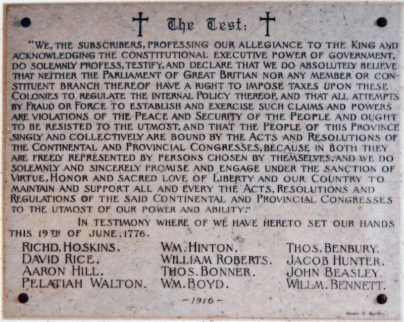
Marker detail: “The Test”
| 101 ► North Carolina, Chowan County, Edenton — 12 — 1736 St. Paul's Episcopal Church — Parish Organized under Act of Assembly 1701 — Edenton Historical Commission Museum Trail — |
| On West Church Street just west of North Broad Street (State Highway 32), on the right when traveling west. | |||
| 102 ► North Carolina, Chowan County, Edenton — 2 — Sea Port Fame Brings Famous Forefathers — Nation's Leaders, to Edenton — Edenton Historical Commission Museum Trail — |
| Near South Broad Street, 0.1 miles south of East Water Street, on the left when traveling south. | |||
| 103 ► North Carolina, Chowan County, Edenton — Site of the Old Cupola House Kitchen? — |
| Near South Broad Street south of West King Street, on the right when traveling south. | |||
| 104 ► North Carolina, Chowan County, Edenton — A-46 — Weapemeoc — |
| On West Queen Street (Business U.S. 17) at Dickinson Street, on the right when traveling east on West Queen Street. | |||
| 105 ► North Carolina, Cleveland County, Grover — O-22 — North Carolina / South Carolina — |
| On M H Camp Hwy (Route 29). | |||
| 106 ► North Carolina, Cleveland County, Kings Mountain — William Andrew Mauney House — Local Historic Landmark — |
| On N Battleground Avenue (State Highway 216). | |||
| 107 ► North Carolina, Columbus County, Tabor City — Mt. Tabor — |
| On East 5th Street (Business U.S. 701) at Pireway Road (North Carolina Highway 904), on the right when traveling south on East 5th Street. | |||
| 108 ► North Carolina, Craven County, Fort Barnwell — C-32 — Fort Barnwell — |
| On State Highway 55 near Belltown & Biddle Roads, on the right when traveling south. | |||
| 109 ► North Carolina, Craven County, New Bern — Abner Nash — |
| On Broad Street (U.S. 17) at Craven Street on Broad Street. | |||
| 110 ► North Carolina, Craven County, New Bern — C-10 — Baron Christoph von Graffenried — |
| On East Front Street just north of Broad Street, on the right when traveling north. | |||
| 111 ► North Carolina, Craven County, New Bern — Ebenezer Presbyterian Church — 1880-1992 — |
| On Queen Street at Pasteur Street, on the left when traveling east on Queen Street. | |||
| 112 ► North Carolina, Cumberland County, Fayetteville — I-54 — Campbelton — |
| On Person Street at Broad Street, on the right when traveling east on Person Street. | |||
| 113 ► North Carolina, Cumberland County, Fayetteville — I-10 — Cross Creek — |
| On Bow Street at Person Street, on the left when traveling north on Bow Street. | |||
| 114 ► North Carolina, Cumberland County, Fayetteville — Cross Creek Linear Park — Our Pathway to the Future — |
| 115 ► North Carolina, Cumberland County, Fayetteville — Flora MacDonald — |
| On Bow Street at Green Street, on the left when traveling west on Bow Street. | |||
| 116 ► North Carolina, Cumberland County, Fayetteville — Parade Ground — Fayetteville Independent Light Infantry — |
| On Cool Spring Street at Meeting Street, on the right when traveling south on Cool Spring Street. | |||
| 117 ► North Carolina, Cumberland County, Fayetteville — I-21 — Plank Roads — |
| On Green Street, on the right when traveling north. | |||
| 118 ► North Carolina, Cumberland County, Fayetteville — Scotch Spring — |
| On Hay Street at Pittman Street, on the left when traveling east on Hay Street. | |||
| 119 ► North Carolina, Cumberland County, Fayetteville — Settlement of the Upper Cape Fear — |
| On Hay Street, on the left when traveling east. | |||
| 120 ► North Carolina, Cumberland County, Linden — I-52 — Rev. James Campbell — |
| On Ramsey Street (U.S. 401) at East Reeves Bridge Road, on the right when traveling north on Ramsey Street. | |||
| 121 ► North Carolina, Currituck County, Corolla — Corolla Historic Village — |
| On Corolla Village Road at Schoolhouse Lane, on the left when traveling south on Corolla Village Road. | |||
| 122 ► North Carolina, Currituck County, Corolla — Corolla Schoolhouse — C. 1900 — |
| On Schoolhouse lane at Corolla Village Road, on the left when traveling west on Schoolhouse lane. | |||
| 123 ► North Carolina, Currituck County, Corolla — Corolla Schoolhouse — |
| On Corolla Village Road at Schoolhouse Lane, on the left when traveling south on Corolla Village Road. | |||
| 124 ► North Carolina, Currituck County, Corolla — First Swimming Pool on the Outer Banks — |
| Near Ocean Trail (State Highway 12) at Club Road. | |||
| 125 ► North Carolina, Currituck County, Corolla — Ray T. Adam's Landing Strip — |
| Near Ocean Trail (State Highway 12) at Club Road. | |||
| 126 ► North Carolina, Currituck County, Corolla — The Caretaker's Residence — |
| Near Ocean Trail (State Highway 12) at Club Road. | |||
| 127 ► North Carolina, Currituck County, Corolla — The Knights — |
| Near Ocean Trail (State Highway 12) at Club Road. | |||
| 128 ► North Carolina, Currituck County, Corolla — The Whalehead Club Restoration — |
| On Ocean Trail (State Highway 12) at Club Road on Ocean Trail. | |||
| 129 ► North Carolina, Currituck County, Currituck — Currituck County Old Jail — |
| On Courthouse Road (State Highway 1242) near Caratoke Highway (State Highway 168), on the right when traveling north. | |||
| 130 ► North Carolina, Currituck County, Shawboro — A-47 — Yeopim — |
| On Indiantown Road at Shortcut Road (U.S. 158), on the left when traveling south on Indiantown Road. | |||
| 131 ► North Carolina, Dare County, Avon — Welcome to Kinnakeet... — Outer Banks National Scenic Byway — |
| On State Highway 12 at Yucca Street, on the left when traveling north on State Highway 12. | |||
| 132 ► North Carolina, Dare County, Frisco — Welcome to Frisco — Outer Banks National Scenic Byway — |
| On State Highway 12 at Timber Trail, on the left when traveling north on State Highway 12. | |||
| 133 ► North Carolina, Dare County, Hatteras — Welcome to Hatteras Village — Outer Banks National Scenic Byway — |
| Near State Highway 12 near Elizabeth Avenue, on the right when traveling south. | |||
| 134 ► North Carolina, Dare County, Manteo — A Civil War Refuge — Fort Raleigh National Historic Site — |
| Near Fort Raleigh Road, 0.3 miles north of U.S. 64. | |||
| 135 ► North Carolina, Dare County, Manteo — A Legacy of Freedom — Fort Raleigh National Historic Site — |
| Near Fort Raleigh Road, 0.3 miles north of U.S. 64. | |||
| 136 ► North Carolina, Dare County, Manteo — A Tribute to Roanoke Islands Native Inhabitants — |
| Near Festival Park at Anasias Dare Street. | |||
| 137 ► North Carolina, Dare County, Manteo — B-44 — Andrew Cartwright — |
| On North Virginia Dare Avenue (U.S. 64/264) at Russel Twiford Road, on the right when traveling west on North Virginia Dare Avenue. | |||
| 138 ► North Carolina, Dare County, Manteo — Deliverance — Fort Raleigh National Historic Site — National Park Service, U.S. Department of the Interior |
| On Freedman's Colony Road near U.S. 64/264, on the right when traveling west. Reported permanently removed. | |||
| 139 ► North Carolina, Dare County, Manteo — English Explorers' Earthwork — Fort Raleigh National Historic Site — |
| Near Fort Raleigh Road, 0.4 miles north of U.S. 64, on the left when traveling north. | |||
| 140 ► North Carolina, Dare County, Manteo — Exploring the Unknown — Fort Raleigh National Historic Site — |
| Near Fort Raleigh Road north of National Park Road when traveling north. | |||
| 141 ► North Carolina, Dare County, Manteo — B-1 — First English Colonies — |
| Near U.S. 64, 0.2 miles east of the William B. Umstead Memorial Bridge, on the right when traveling east. | |||
| 142 ► North Carolina, Dare County, Manteo — First Light of Freedom — The Freedmen’s Colony of Roanoke Island — National Underground Railroad - Network To Freedom — |
| Near National Park Drive, 3 miles U.S. 64. | |||
| 143 ► North Carolina, Dare County, Manteo — The New Fort in Virginia / Virginia Dare — |
| Near National Park Drive, 3 miles U.S. 64. | |||
| 144 ► North Carolina, Dare County, Manteo — The Roanoke Colonies — |
| Near Queen Elizabeth Avenue near Budleigh Street, on the left when traveling south. | |||
| 145 ► North Carolina, Dare County, Manteo — To Virginia Dare — |
| On Queen Elizabeth Avenue at Budleigh Street, on the right when traveling north on Queen Elizabeth Avenue. | |||
| 146 ► North Carolina, Dare County, Manteo — To Walter Raleigh's Colonists — 1584 - 1587 — |
| On Queen Elizabeth Avenue at Budleigh Street, on the right when traveling north on Queen Elizabeth Avenue. | |||
| 147 ► North Carolina, Davidson County, Lexington — Captain Peter Hedrick — Dec. 17, 1733 – Jan. 24, 1798 — |
| On Becks Church Road, 0.2 miles north of Homestead Drive, on the right when traveling north. | |||
| 148 ► North Carolina, Davidson County, Lexington — City of Lexington — Incorporated 1828 — |
| On North Main Street at West Center Street, on the right when traveling south on North Main Street. | |||
| 149 ► North Carolina, Davidson County, Lexington — Daniel Boone and Gen. Nathanael Greene — |
| On North Main Street near W Center Street, on the right when traveling south. | |||
| 150 ► North Carolina, Davidson County, Lexington — K-56 — Wm. Rainey Holt — 1798-1868 — |
| On S Main Street, on the right when traveling south. | |||
| 151 ► North Carolina, Davidson County, Thomasville — John W. Thomas — |
| On West Main Street west of Salem Street (North Carolina Highway 109), on the right when traveling west. | |||
| 152 ► North Carolina, Davidson County, Thomasville — K-35 — John W. Thomas — 1800-1871 — |
| On Cedar Lodge Road at Cedar Drive, on the right when traveling east on Cedar Lodge Road. | |||
| 153 ► North Carolina, Davidson County, Thomasville — Thomasville — A Key Stop & Refuge — |
| On West Main Street at Trade Street, on the left when traveling west on West Main Street. | |||
| 154 ► North Carolina, Davie County, Cooleemee — Cooleemee's Old Square — |
| On Main Street at Duke Street, on the right when traveling north on Main Street. | |||
| 155 ► North Carolina, Davie County, Mocksville — Boone Memorial — This Memorial Erected To — Daniel Boone | Squire and Sarah Boone — |
| On Main Street at Court Square, on the left when traveling south on Main Street. | |||
| 156 ► North Carolina, Davie County, Mocksville — M-47 — Boone Tract — |
| On Wilkesboro Street (U.S. 64), on the left when traveling east. | |||
| 157 ► North Carolina, Davie County, Mocksville — Daniel Boone / Greene and Cornwalis — |
| On Farmington Road at Highway 801, on the left when traveling north on Farmington Road. | |||
| 158 ► North Carolina, Davie County, Mocksville — M-3 — Daniel Boone's Parents |
| On Yadkinville Road (U.S. 601), on the right when traveling north. Reported missing. | |||
| 159 ► North Carolina, Davie County, Mocksville — The Boone Family in Davie County — |
| Near Yadkinsville Road. | |||
| 160 ► North Carolina, Duplin County, Kenansville — F-4 — Grove Church — |
| On South Main Street south of Stokes Street, on the left when traveling south. | |||
| 161 ► North Carolina, Durham County, Chapel Hill — Christopher "Old Kit" Barbee — C. 1738 - 1832 — |
| On Dubose Home Lane, 0.7 miles east of Meadowmont Lane, on the right when traveling east. | |||
| 162 ► North Carolina, Durham County, Durham, Downtown — Dr. Bartlett Durham — |
| On East Main Street west of South Roxboro Street (Business U.S. 70), on the right when traveling east. | |||
| 163 ► North Carolina, Edgecombe County, Princeville — E-97 — Freedom Hill — |
| On State Route 33 (Business U.S. 64) at Mutual Blvd (U.S. 258), on the right when traveling north on State Route 33. | |||
| 164 ► North Carolina, Edgecombe County, Rocky Mount — Around the "Y" Community — |
| On South Washington Street south of Hendricks Street, on the right when traveling south. | |||
| 165 ► North Carolina, Edgecombe County, Rocky Mount — Lincoln Park Historic District — |
| On Leggett Road at Carver Place, on the left when traveling east on Leggett Road. | |||
| 166 ► North Carolina, Edgecombe County, Tarboro — E-18 — Town Common — |
| On North Main Street (U.S. 64), on the right when traveling north. | |||
| 167 ► North Carolina, Forsyth County, Bethania — Alpha Chapel — constructed 1895 — |
| Near Bethania Road. | |||
| 168 ► North Carolina, Forsyth County, Bethania — Bethania — Founded 12 June 1759 — |
| On Bethania Road, 0.1 miles east of Main Street, on the left when traveling west. | |||
| 169 ► North Carolina, Forsyth County, Bethania — Bethania — Established 1759 — |
| Near Bethania Road. | |||
| 170 ► North Carolina, Forsyth County, Bethania — J-69 — Great Wagon Road — |
| On Bethania Rural Hall Rd., 0.1 miles east of Main St., on the left when traveling east. | |||
| 171 ► North Carolina, Forsyth County, Bethania — Wolff-Moser House — circa 1799 — |
| Near Bethania Road. | |||
| 172 ► North Carolina, Forsyth County, Clemmons — Philip and Johanna Hoehns (Hanes) House — |
| On Middlebrook Drive north of Idols Road, on the right when traveling south. | |||
| 173 ► North Carolina, Forsyth County, Clemmons — J-110 — Wachovia Tract — |
| On South Stratford Road (U.S. 158) at Bryn Mawr Lane (North Carolina Highway 1115), on the right when traveling east on South Stratford Road. | |||
| 174 ► North Carolina, Forsyth County, Clemmons — William Johnson — |
| On Tanglewood Park Road at River Birch Creek, on the right when traveling south on Tanglewood Park Road. | |||
| 175 ► North Carolina, Forsyth County, Clemmons — William Linville — (c. 1711-1766) — Militia Captain and "Long Hunter" — |
| On Tanglewood Park Road at Manor House Creek, on the left on Tanglewood Park Road. | |||
| 176 ► North Carolina, Forsyth County, Kernersville — Site of Historic Beeson's Crossroad Trading Post — |
| On Union Cross Road at Sedge Garden Road, on the left when traveling north on Union Cross Road. | |||
| 177 ► North Carolina, Forsyth County, Lewisville — George Mock House — |
| On Shallowford Road at Summerglen Drive, on the right when traveling east on Shallowford Road. | |||
| 178 ► North Carolina, Forsyth County, Lewisville — Great Philadelphia Wagon Road — ca. 1754 — |
| On Great Wagon Road, on the right. | |||
| 179 ► North Carolina, Forsyth County, Lewisville — Vogler-Reynolds House — |
| On Reynolds Road at Manarda Circle, on the left when traveling north on Reynolds Road. | |||
| 180 ► North Carolina, Forsyth County, Oldtown — Apothecary Shop 1763 — |
| Near Bethabara Road, on the right when traveling east. | |||
| 181 ► North Carolina, Forsyth County, Oldtown — Bake Oven 1753 — (reconstructed) — |
| Near Bethabara Road, on the right when traveling east. | |||
| 182 ► North Carolina, Forsyth County, Oldtown — Bastion 1756 — |
| Near Bethabara Road, on the right when traveling east. | |||
| 183 ► North Carolina, Forsyth County, Oldtown — Bell House — (reconstructed) — |
| Near Bethabara Road, on the right when traveling east. | |||
| 184 ► North Carolina, Forsyth County, Oldtown — Bethabara — Historic Bethabara Park • 1753 — |
| On Bethabara Road east of Bethania Station Road, on the right when traveling east. | |||
| 185 ► North Carolina, Forsyth County, Oldtown — Bethabara Fort 1756-63 — (reconstructed) — |
| Near Bethabara Road, on the right when traveling east. | |||
| 186 ► North Carolina, Forsyth County, Oldtown — Bethabara Tavern 1757 — |
| Near Bethabara Road, on the right when traveling east. | |||
| 187 ► North Carolina, Forsyth County, Oldtown — Calf Barn 1765 — (reconstructed) — |
| 188 ► North Carolina, Forsyth County, Oldtown — Community Garden 1759 — (reconstructed) — |
| Near Bethabara Road, on the right when traveling east. | |||
| 189 ► North Carolina, Forsyth County, Oldtown — Congregation Kitchen 1766 — |
| Near Bethabara Road, on the right when traveling east. | |||
| 190 ► North Carolina, Forsyth County, Oldtown — Congregation Store 1759 & 1764 — |
| Near Bethabara Road, on the right when traveling east. | |||
| 191 ► North Carolina, Forsyth County, Oldtown — Congregation Store Addition after 1766 — |
| Near Bethabara Road, on the right when traveling east. | |||
| 192 ► North Carolina, Forsyth County, Oldtown — Distiller's House 1803 |
| On Bethabara Road, on the right when traveling north. Reported missing. | |||
| 193 ► North Carolina, Forsyth County, Oldtown — Doctor's Laboratory 1759 — |
| Near Bethabara Road. | |||
| 194 ► North Carolina, Forsyth County, Oldtown — Dwelling House/Cow House 1754 — (reconstructed) — |
| Near Bethabara Road, on the right when traveling east. | |||
| 195 ► North Carolina, Forsyth County, Oldtown — Family House 1758 — |
| Near Bethabara Road, on the right when traveling east. | |||
| 196 ► North Carolina, Forsyth County, Oldtown — Flour Bin 1758 — |
| Near Bethabara Road, on the right when traveling east. | |||
| 197 ► North Carolina, Forsyth County, Oldtown — Gemeinhaus 1756 — |
| Near Bethabara Road, on the right when traveling east. | |||
| 198 ► North Carolina, Forsyth County, Oldtown — Gemeinhaus 1788 — |
| 199 ► North Carolina, Forsyth County, Oldtown — Hans Wagner Cabin 1752 — (reconstructed) — |
| Near Bethabara Road, on the right when traveling east. | |||
| 200 ► North Carolina, Forsyth County, Oldtown — Locksmith and Gunsmith Shop 1759 — |
| Near Bethabara Road, on the right when traveling east. | |||
494 entries matched your criteria. Entries 101 through 200 are listed above. ⊲ Previous 100 — Next 100 ⊳