Near State Highway 62, 0.2 miles south of Oakbury Road, on the right when traveling south.
A little known Revolutionary War engagement occurred on the Regulator battlefield on March 1, 1781. Ten years after the Battle of Alamance, and approximately two weeks before the Battle of Guilford Courthouse near Greensboro, soldiers of the . . . — — Map (db m139346) HM
On NC Highway 62 at Clapp Mill Road, on the left when traveling south on NC Highway 62.
Here was fought (I) on May 16, 1771, the Battle of Alamance. Opposing forces were colonial militia, mainly from the eastern part of the province, commanded by Governor William Tryon, and a band of frontier dwellers known as Regulators, who had risen . . . — — Map (db m35055) HM
On State Highway 62, 0.1 miles east of Clapp Mill Road, on the right when traveling east.
Alamance County citizens took the first steps to mark the site of the Battle of Alamance in 1879. On July 4, Rev. D. A. Long delivered a speech here, urging area residents to form an association with the charge of erecting a monument. Less than a . . . — — Map (db m139689) HM
Battle of Clapp's Mill
On March 2, 1781, the American light troops under Colonel Otho Holland Williams of Maryland and Lieutenant Colonel Henry "Lighthouse Harry" Lee of Virginia engaged the British light troops near Clapp's Mill on Beaver . . . — — Map (db m28062) HM
On North Carolina 62 (North Carolina Route 62) at Porter Sharpe Road, on the right when traveling south on North Carolina 62.
Troops led by Henry Lee ambushed British cavalry of Banastre Tarleton one mile north, Mar. 2, 1781. Americans retreated under heavy British fire. — — Map (db m222722) HM
On North Carolina Route 62 at Clapp Mill Road, on the right when traveling east on State Route 62.
This column was erected in 1901 at Guilford Courthouse National Military Park as a testament to the Battle of Alamance being the "first battle of the American Revolution." But as early as 1937, the National Park Service questioned the . . . — — Map (db m222751) HM
On North Carolina 62 (State Highway 62) east of Clapp Mill Road, on the left when traveling west.
[ Rear of Monument ] Here was fought the Battle of Alamance between the British and the Regulators ------------- [ Right of Monument ] Liberty [ Left of Monument ] 1880 — — Map (db m222725) HM
On State Highway 62 at Clapp Mill Road, on the right when traveling east on State Highway 62.
This advantageous position was held by Royal Governor William Tryon and his North Carolina militia during the Battle of Alamance. The men serving Governor Tryon were not British "Redcoats," but the citizen soldiers from the colony of North Carolina. . . . — — Map (db m139724) HM
Near State Highway 62, 0.2 miles south of Oakbury Road, on the right when traveling south.
According to legend, Regulator James Pugh, brother-in-law of Regulator Herman Husband, lay behind this rock while he fired on Tryon's troops. Tradition has also held since 1942 that James was taken prisoner and hanged in Hillsborough on June 19, . . . — — Map (db m139350) HM
On Anthony Road at Old Trail, on the right when traveling east on Anthony Road.
Near this location, mounted Loyalists from Chatham and southern Orange counties led by Col. John Pyle, and on their way to join Gen. Cornwallis in Hillsborough, were defeated by units of Gen. Greene's American Army led by Col. Henry "Light Horse . . . — — Map (db m34718) HM
On Maple Avenue near Anthony Road, on the right when traveling south. Reported permanently removed.
A body of Tories, going to join Cornwallis' Army at Hillsborough, was destroyed by a Whig force, Feb. 23, 1781. ¾ mile southwest. — — Map (db m28524) HM
Near North Carolina Route 62 south of Oakbury Road, on the right when traveling south.
On May 16, 1771, North Carolina militia. commanded by Royal Governor William Tryon, defeated the Regulators on this site. The pennants represent the second, or decisive, positions of the two armies and the Regulator camp. — — Map (db m222801) HM
On North Carolina 62 (State Highway 62) west of Clapp Mill Road, on the left when traveling west.
The first battle of the Revolutionary War, was fought in Orange County, North Carolina May 16th, 1771. [ Right of Monument ] 1771 – 81 1901 James Hunter “General” of the Regulators. “The country is as much master now as ever.” . . . — — Map (db m222730) HM
Near North Carolina Route 62, 0.2 miles south of Oakbury Road, on the right when traveling south.
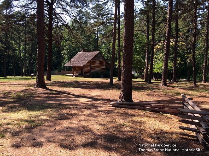
Quaker John Allen constructed this log dwelling circa 1780 in nearby Snow Camp. The State of North Carolina moved it here in 1966, restored it, and opened it to the public in 1967 to illustrate colonial life in the backcountry of North Carolina. The . . . — — Map (db m42253) HM
(Preface): The Carolinas Campaign began of February 1, 1865, when Union Gen. William T. Sherman led his army north from Savannah, Georgia, after the March to the Sea. Sherman's objective was to join Gen. Ulysses S. Grant in Virginia to crush . . . — — Map (db m42335) HM
On North Carolina Route 62 north of Pond Road (Route 0.2), on the right when traveling north.
Before and after the battle of Alamance, the militia of Governor William Tryon camped nearby, along Alamance Creek, May 13-19, 1771. — — Map (db m222809) HM
On Hanford Hills Road at Monticello Court, on the left when traveling south on Hanford Hills Road.
An early pioneer, leader and landowner, Michael Holt II was the son of Michael Holt I who had moved to this area in he 1750s. He is buried nearby with his two wives, “Peggy” O'Neal and Jean Lockhart. He had ten children who became the ancestors of . . . — — Map (db m223106) HM
On North 5th Street (U.S. 70) at South 5th Street (North Carolina Route 119), on the right when traveling east on North 5th Street.
Brigadier general of North Carolina militia, member House of Commons, conventions 1788, 1789, and U.S. Congress. His home stood nearby. — — Map (db m223043) HM
A memorial to British troops who died in the Old Meeting House during Cornwallis encampment here on his retreat from Guilford Courthouse March 1781.
Erected by Troop 46 B.S.A. Henry Overman Leader Who Died Before Completing It. — — Map (db m30558) HM
On these grounds, Revolutionaries and Loyalists were buried together in mass graves by people of this neighborhood, who also cared for the wounded in their homes. Additional burials are at Spring Meeting House. — — Map (db m30695) HM
On Snow Camp Road, 0.2 miles south of Greensboro-Chapel Hill Road.
Settled by Quakers in 1749. Cornwallis camped in area after Battle of Guilford Courthouse and used home of Simon Dixon as headquarters. — — Map (db m223102) HM
At this site, Patriot militia commanded by Brigadier General John Butler ambushed loyalist militia commanded by Colonel David Fanning in an effort to free prisoners, whom the Loyalist had captured at Hillsborough the previous day.
Although losses . . . — — Map (db m30696) HM
Near East Greensboro Chapel Hill Road at Stockard Road, on the left when traveling east.
In Memory of the Whig and Tory Soldiers who died in the Battle of Lindley's Mill 14th D. 11 Mo. 1781 and were buried here and on the battlefield
Erected 7th Day 10 Mo. 1979 — — Map (db m223104) HM
On North Main Street (U.S. 21) just north of East Whitehead Street (State Highway 18), on the right when traveling north.
[southwest side]Coast Guard • Army • Air Force • Navy • Marine Corps ☆ Dedicated to the honor and sacrifice of our Men and Women who served our Country in War and Peace ☆[northeast . . . — — Map (db m227326) WM
Appalachian Trail, Yellow Mountain Gap. Yellow Mountain Gap is the junction of the Appalachian Trail and Historic Bright’s Trace, route used by the “Overmountain Men” to cross the mountain enroute to the Revolutionary War battle at . . . — — Map (db m3269) HM
On North Bonner Street at East Main Street, on the right when traveling north on North Bonner Street.
Washington's original "free" church, open to all denominations, was constructed on lot 50 of the town's plat, created by Col. James Bonner, the founder of Washington, circa 1776. Bonner and two other Revolutionary War soldiers are buried here. . . . — — Map (db m226315) HM
On West Stewart Parkway at South Respess Street, on the right when traveling east on West Stewart Parkway.
The Original Washington
The history of Washington began around 1585 when English explorers first visited the area that would become Washington. The easily navigable waters and excess of natural resources made the area a very successful port . . . — — Map (db m226611) HM
On South King Street (State Highway 308) at East Gray Street, on the right when traveling south on South King Street.
Member of Continental Congress, signer of the Federal Constitution, governor S.W. Territory, Senator from Tennessee. Birthplace ⅕ mi. S.W. — — Map (db m60649) HM
On Elwell Ferry Road (County Route 1730) at North Carolina Highway 87, on the right when traveling east on Elwell Ferry Road.
One and one-half miles northeast stands Oakland, the home
of General Thomas Brown, an officer of the Revolution, 1747-1814. Staunch patriot, statesman, planter. — — Map (db m215474) HM
On State Highway 87 just east of State Highway 131, on the right when traveling west.
Colonel in Revolution, member of provincial congresses and state senator. Robeson County is named for him. His home stood ½ mile N.E. — — Map (db m222331) HM
On Light House Wynd at Ballast Stone Alley, on the left when traveling west on Light House Wynd.
British troops constructed Fort George to defend Bald Head Island and their warships’ anchorage at the mouth of the Cape Fear River. American forces attacked the fort, but were repulsed, in early September 1776. This was believed to be the first . . . — — Map (db m115744) HM
On River Road SE (State Highway 133) south of U.S. 17, on the right when traveling south.
Associate Justice United States Supreme Court, 1799–1804, officer in the Revolution, state Attorney General, Judge. Home was 18¾ mi. S. — — Map (db m215669) HM
Erected by Captain John Russell, Commander of His Britannic Majesty's Sloop of War Scorpion, who gave his name to this residence and tract of fifty-five acres of land adjacent to the town of Brunswick. Subsequently owned and occupied by the . . . — — Map (db m22372) HM
On Plantation Road north of Plantation Road, on the left when traveling south.
Founded c. 1725, long a principal port of N.C., site of Spanish attack, 1748, and of Stamp Act resistance, 1766. Later abandoned. Was 2 mi. S.E. — — Map (db m6451) HM
On East Bay Street east of South Davis Street, on the left when traveling east.
This tablet was erected May, 1911 by the North Carolina Society of Colonial Dames of America to mark the site of Fort Johnston, the first fort in the Province of North Carolina, built under Act of Assembly of 1745 and completed 1764, and named in . . . — — Map (db m4754) HM
On East Bay Street east of South Davis Street, on the left when traveling east.
Last royal governor of North Carolina, 1771–75. Fearing capture, in June 1775 he sought refuge here. Fled offshore to HMS Cruizer in July. — — Map (db m4790) HM
A memorial to Colonel Maurice Moore, gentleman and soldier of the King, who in the year of our lord 1725 founded in a wilderness The Town of Brunswick reserving for the glory of God the tract of land on which was built this parish church . . . — — Map (db m6510) HM
Dedicated to the memory of
Samuel Ashe
1725 - 1813
Distinguished North Carolinian
Governor, Statesman and Jurist
in whose honor
the City of Asheville was named
— — Map (db m30120) HM
On College Street at Davidson Drive, on the right when traveling north on College Street.
James Alexander •
Zebulon Baird •
William Brittain •
Adam Cooper •
Samuel Davidson •
William Davidson •
Lot Harper •
Joseph Harrison •
William Moore •
John Patton •
Daniel Smith •
Valentine Thrash •
David Vance •
Robert Williamson . . . — — Map (db m231266) HM
On East Union Street (Business U.S. 70) at Lenoir Street, on the right when traveling south on East Union Street.
Hero of the Battle of Cowpens during the American Revolution. Burke County Patriot Militia fought alongside Morgan, a Virginian. In 1784 the Town of Morgansborough was established in his honor. The name was changed to Morganton in 1838. — — Map (db m187663) HM
On Greenlee Ford Road, 0.2 miles north of Carbon City Road (U.S. 70) when traveling north.
A patriot militia of about 1,500 men crossed this ford heading south on the morning of October 1, 1780. They were pursuing in enemy force led by Major Patrick Ferguson of the British Army. The men came from as far away as present-day eastern . . . — — Map (db m210355) HM
On North Green Street (State Highway 181) at St Marys Church Road on North Green Street.
Rendezvous for "Over-Mountain Men" prior to Battle of Kings Mountain, 1780. Home of Joseph & Charles McDowell, military & political leaders. — — Map (db m99602) HM
Near Branstrom Drive, 0.2 miles north of Sam Wall Avenue when traveling north.
In gratitude for the valor
of these Revolutionary War patriots
whose fight for independence secured our liberty
General Charles McDowell • Major Joseph McDowell • Margaret O'Neal McDowell • Grace Greenlee McDowell • Colonel Alexander Erwin . . . — — Map (db m240438) WM
Near McConnaughey Lane, 5 miles south of Swan Pond Drive (County Road 1297), on the left when traveling south.
Col. Waightstill Avery
1741-1821
Revolutionary War
Patriot
Col. Waightstill Avery
First Attorney General
for the
State of North Carolina
1778-1779 — — Map (db m210351) HM WM
On North Green Street (State Highway 181) at Bost Road on North Green Street.
First Attorney General of North Carolina, 1777-79, member provincial Congresses, colonel in Revolution. "Swan Ponds," his home, was 3 mi. S.W. — — Map (db m99607) HM
On Union Street South just north of Means Avenue Southeast, on the right when traveling south.
Red Hill Tavern was home to Martin Pheifer, Jr. Mr. Pheifer was a good friend of George Washington, having served with him at Valley Forge. For that reason President Washington was a private guest of Pheifer during his Southern Tour, dining and . . . — — Map (db m175756) HM
On Yadkin River Road (County Route 1560) at North Carolina Highway 268, on the right when traveling north on Yadkin River Road.
Home of William Lenoir, leader in Revolution & public affairs. Built 1788-92 and named for colonial fort on the site 4½ miles east. — — Map (db m77550) HM
On State Highway 343 at NC Highway 34 North (U.S. 158), on the left on State Highway 343.
Member of provincial congresses, 1775–1776; lieutenant colonel of militia in Revolution; Congressman, 1795–99. Grave is 7 miles S.E. — — Map (db m2768) HM
On U.S. 158 at 343, on the right when traveling east on U.S. 158.
Member provincial congress, 1775; brigadier general of militia in Revolution; member N.C. conventions, 1788-1789. Home is 4 miles S.E. — — Map (db m165197) HM
On State Highway 343, 0.1 miles south of U.S. 158, on the right when traveling south.
Member provincial congress, 1775; brigadier general of militia in Revolution; member N.C. conventions, 1788-1789. Home was 4 mi. S.E. — — Map (db m165199) HM
On Ann Street west of Craven Street, on the right when traveling west.
Deeded to town, 1731, by Nathanael Taylor. Capt. Otway Burns of the War of 1812, Revolutionary and Civil War soldiers are buried here. — — Map (db m77031) HM
On State Highway 119 at State Highway 57, on the right when traveling north on State Highway 119.
Presbyterian. Founded about middle of 18th century. Hugh McAden, its noted pastor, was buried in the churchyard, 1781. One mile S. — — Map (db m216379) HM
Near U.S. 70, 0.2 miles east of Bridgewood Drive, on the left when traveling east.
County commissioners, in 1894, called local land owners to build and maintain a bridge across Lyles Creek. In response, landowners hired the services of Andy J. Ramsour, keeper of Horse Ford covered bridge over the Catawba River, at Hickory. In . . . — — Map (db m70563) HM
Near Greenway Avenue north of Windy Holly Lane when traveling north.
Although the son of a Tory he chose the cause of
American independence. In 1776 he was hanged
by a band of Tories from a nearby tree. The
body was prepared for burial by Simon Haas and
interred here – the beginning of this cemetery.
Three years . . . — — Map (db m240770) HM
Near Greenway Avenue north of Windy Holly Lane when traveling north.
During the early stages of the American Revolution divided
loyalties often erupted in violence. In 1776, neighbors
supporting the British monarchy hanged 15-year-old Patriot
Isaac Wise not far from where you stand today. Fellow Patriot
Simon . . . — — Map (db m240754) HM
On North College Avenue at East A Street, on the left when traveling north on North College Avenue.
A tribute to Mathias Barringer, Lipsicom Adam, - Grundt, - Haas, - Wilson, and another, who were massacred on John's River in Gen. Rutherford's "forced march" against the Cherokees in 1776, and to Philip Fry who alone escaped, and to Conrad Tippong, . . . — — Map (db m156715) HM WM
On Old US Highway 1 (County Route 1011) 0.1 miles south of Moncure Pittsboro Road (County Route 1012), on the right when traveling south.
Cornwallis, following the battle of Guilford Courthouse, spent several days building a bridge over Deep River, at point 300 yards N.W. — — Map (db m218157) HM
On Siler City Snow Camp Road, 0.4 miles north of Edwards Road, on the right when traveling north.
The first Siler to settle in this area. He came from Germany to America in 1738 and moved here about 1760. He built a grist mill just east of the present bridge over Rocky River. He furnished supplies during the Revolutionary War and was declared a . . . — — Map (db m233317) HM
On U.S. 19, 3.8 miles south of U.S. 64, on the left when traveling south. Reported missing.
North Carolina. Colonized, 1585-87, by first English settlers in America; permanently settled c. 1650; first to vote readiness for independence, Apr. 12, 1776.
Georgia. The colony of Georgia was chartered in 1732, named for King George . . . — — Map (db m25333) HM
On West Church Street just west of North Broad Street (State Highway 32), on the right when traveling west.
1702 Builds first church in North Carolina Three Carolina governors buried herein. Joseph Hewes, signer of Declaration of Independence; Dr. Hugh Williamson, signer of U.S. Constitution; James Iredell, Washington's youngest Supreme . . . — — Map (db m224755) HM
On N Broad St. at Queen Street, on the right when traveling south on N Broad St..
Home of Thomas Barker, N.C. agent to England, and his wife Penelope, reputed leader of the Edenton "Tea Party," 1774.
Stands 3 blocks south. — — Map (db m34810) HM
On E. Water Street near between Court St. and Colonial Ave.
Bought in France for N.C. by Robt. Smith & Thos. Benbury agents for Governor Caswell. Brought to Edenton by Capt. Boritz on "The Holy Heart of Jesus" in 1778. Mounted on this spot 1861. Spiked and trunnions broken off by Federal Fleet 1862. . . . — — Map (db m34965) HM
On East Water Street east of Court Street, on the right when traveling east.
Granite Monument erected September 17, 2017, Honors
Hugh Williamson, son of Scotch-Irish parents, was born 1735. in Nottingham, Pennsylvania. His parents wanted him to become a Presbyterian minister, but his quest for knowledge took him in . . . — — Map (db m225261) HM
On West Queen Street west of South Broad Street, on the left when traveling west. Reported missing.
Fifty-one women met at Mrs. Elizabeth King's home, which stood 1100 ft. S.E., and resolved, Oct. 25, 1774, to support the American Cause. — — Map (db m34850) HM
On Colonial Avenue north of East Water Street, on the left when traveling north.
Sculpted in 1905 by Frank Baldwin, Foundryman This Tea Pot memorializes an inspiring story that tells of patriotism and bravery. See (1864) below for another, little known, but unforgettable saga of Edenton that is an amazing twist . . . — — Map (db m224500) HM
On Haughton Road at Soundside Road, on the right when traveling south on Haughton Road.
Colonial statesman and Brigadier General of the Edenton District militia. Member, N.C. Committee of Correspondence, 1768, 1773-74. Lived 2 mi. SW. — — Map (db m226505) HM
On East Water Street just west of Court Street, on the right when traveling west.
[south side]To the Memory of Joseph Hewes April 28, 1730 November 10, 1779[east side]Modestly but without stint he gave his Labor and his Means to the cause of Freedom[north side]Vestryman of St. . . . — — Map (db m225291) HM
On East Water Street at Colonial Avenue, on the right when traveling west on East Water Street.
Hewes fought for independence in Continental Congress 1730: Joseph Hewes is born on Mayberry Hill, a 400-acre farm in Kingston, NJ. 1747: Attended Princeton, became a successful merchant in Philadelphia. He . . . — — Map (db m225283) HM
On South Broad Street south of East Water Street, on the left when traveling south.
America’s first female political activist. Leader of 51 women who signed a Proclamation of Protest in 1774 known as The Edenton Tea Party; The first organized political activity by women in our country, encouraged women to boycott English goods. An . . . — — Map (db m224300) HM
On South Broad Street south of East Water Street, on the left when traveling south.
A Brief History of the Barker House1757 Thomas Barker marries Penelope Padgett. Penelope, 28 years old, twice widowed, had inherited substantial wealth. 1761 Thomas travels to London as North Carolina . . . — — Map (db m224302) HM
On Colonial Avenue north of East Water Street, on the left when traveling north.
On this spot stood the residence of Mrs. Elizabeth King in which the ladies of Edenton met Oct. 25, 1774 to protest against the tax on tea — — Map (db m158742) HM
On East Water Street east of Court Street, on the right when traveling east.
(side 1)
Hugh Williamson
Born Dec. 5, 1735
Chester County
Pennsylvania
Died May 22, 1819
New York City
Buried in
Trinity Churchyard
Framer and Signer
of the
U.S. Constitution
Citizen of
Edenton, . . . — — Map (db m225264) HM
On M H Camp Highway (U.S. 29) north of Interstate 81, on the left when traveling north.
Tory force led by Col. Ferguson camped nearby Oct. 4-5, 1780. Two days later Ferguson died in major British defeat at Kings Mountain, 5 mi. SE. — — Map (db m49964) HM