On South Broad Street south of East Water Street, on the left when traveling south.
America’s first female political activist. Leader of 51 women who signed a Proclamation of Protest in 1774 known as The Edenton Tea Party; The first organized political activity by women in our country, encouraged women to boycott English goods. An . . . — — Map (db m224300) HM
On South Broad Street south of East Water Street, on the left when traveling south.
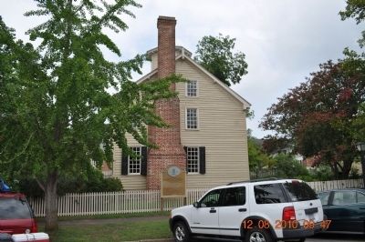
A Brief History of the Barker House1757 Thomas Barker marries Penelope Padgett. Penelope, 28 years old, twice widowed, had inherited substantial wealth. 1761 Thomas travels to London as North Carolina . . . — — Map (db m224302) HM
On Colonial Avenue north of East Water Street, on the left when traveling north.
On this spot stood the residence of Mrs. Elizabeth King in which the ladies of Edenton met Oct. 25, 1774 to protest against the tax on tea — — Map (db m158742) HM
Near Court Street north of East Queen Street, on the right when traveling north.
On this site the Edenton Academy was chartered by Act of Assembly, 1770. Joseph Blount • John Blair • Joseph Hewes Richard Brownrigg • Robert Hardy • Samuel Johnston, Esqrs. Thomas Jones Trustees. ”Prior to this date the inhabitants of Edenton had . . . — — Map (db m226692) HM
On West Queen Street (Business U.S. 17) at South Granville Street, on the right when traveling east on West Queen Street.
Attorney-General of Colony, 1745-1761. Leader of faction which opposed Governor Dobbs. Secretary to Lord Granville. Home was 2 blocks S. — — Map (db m56988) HM
On West Queen Street (Business U.S. 17) at Dickinson Street, on the right when traveling east on West Queen Street.
The principal town of the Weapemeoc Indians, visited by Ralph Lane and his colonists in 1585-1586, stood near present-day Edenton. — — Map (db m56986) HM
On East Water Street east of Court Street, on the right when traveling east.
(side 1)
Hugh Williamson
Born Dec. 5, 1735
Chester County
Pennsylvania
Died May 22, 1819
New York City
Buried in
Trinity Churchyard
Framer and Signer
of the
U.S. Constitution
Citizen of
Edenton, . . . — — Map (db m225264) HM
On North Broad Street (State Highway 32) just north of West Church Street, on the left when traveling north.
This building, begun A.D. 1736 and first used in A.D. 1760, is the third church of St. Paul's Parish, Chowan Precinct, Edenton.
The first, A.D. 1701-02, stoode a mile hence on the sound side. It was the first church building in North . . . — — Map (db m175830) HM
In 1700, the river bottoms surrounding present day Hayesville were home to a thriving Cherokee community called Quanassee. The heart of the village was a townhouse, a combined civic center, council house, and temple that was located atop the mound . . . — — Map (db m41949) HM
North Carolina. Colonized, 1585-87, by first English settlers in America; Permanently settled C.1650; First To vote readiness for Independence, Apr. 12, 1776
South Carolina. Formed in 1712 from part of Carolina, which was chartered . . . — — Map (db m16820) HM
On State Highway 55 near Belltown & Biddle Roads, on the right when traveling south.
Constructed by Colonel John Barnwell of South Carolina in campaign against the Tuscarora Indians in April, 1712. Remains are 2 mi. N. E. — — Map (db m65699) HM
On Broad Street (U.S. 17) at Craven Street on Broad Street.
A resident of New Bern for fifteen years; born in Prince Edward County, Virginia, about 1740, but came to North Carolina in 1763; member of Colonial Assembly from Halifax Town in 1764 and 1765; from the County of Halifax in 1769, 1770 and 1771; . . . — — Map (db m23831) HM
On Pollock Street at Middle Street, on the right when traveling west on Pollock Street.
The walls on this site are erected over the brick and ballast stone foundation of the first house of worship of Colonial Craven Parish which was established in 1715. The brick Anglican Church was completed in 1750, and it continued in use until the . . . — — Map (db m24354) HM
On East Front Street just north of Broad Street, on the right when traveling north.
Merchant, Loyalist, and Governor's Councilor. He financed construction of Tryon Palace & campaign against Regulators, 1771. House stood 2 blocks S. — — Map (db m92399) HM
On Broad Street (Business U.S. 17) at George Street, on the right when traveling east on Broad Street.
Historic Capitol and Governor's residence of N.C., 1770-1794. Burned 1798, and restored in 1952-1959. Open to the public. One block south. — — Map (db m76997) HM
On Person Street at Bow Street, on the right when traveling west on Person Street.
At or near this place
ever since known as
“Liberty Point”
was promulgated in
June 1775,
by patriots of the Cape Fear
A Declaration of Independence
of the British Crown. . . . — — Map (db m24431) HM
On Dick Street south of Halliday Street, on the right when traveling north.
Duncan McLeran constructed this two-story Federal-style dwelling in 1797. In 1820, the property was sold and remodeled to accommodate the Bank of the United States, the first federal bank in North Carolina. The house is named for John Sanford, a . . . — — Map (db m70374) HM WM
On Old Bluff Church Road, 1.2 miles west of Sisk Culbreth Road when traveling west.
Near this spot at Old Bluff Church is buried Colonel Alexander McAllister; Patriot and Revolutionary Hero; Colonel of Cumberland County Militia; Representative First Assembly in Newbern, December 1773; Representative Second Assembly in Newbern, . . . — — Map (db m31594) HM
On Marsh Causeway (County Route 615) near Knotts Island Road.
Commissioners drove
the first stake for
the Virginia - Carolina
boundary, Mar. 18, 1728,
three miles N. E. across
Currituck Sound. — — Map (db m11286) HM
On Caratoke Highway (Route 168) at North Point Road, on the right when traveling south on Caratoke Highway.
In 1728 the Virginia-Carolina boundary was first surveyed from the Atlantic coast to a spot two hundred twenty miles west of here. — — Map (db m2762) HM
On Caratoke Highway (Route 168) at Courthouse Road (North Carolina Highway 1242) on Caratoke Highway.
Preached first Methodist sermon in colony, 1772, at Currituck Courthouse. Pilmoor Memorial Methodist Church is near the site. About 300 ft. north. — — Map (db m2763) HM
On State Highway 12 at Timber Trail, on the left when traveling north on State Highway 12.
Frisco was formerly Trent until the coming of the post office i1898. Hatteras Island’s first inhabitants were the Croatoans. Archaeological evidence proves the Croatoans lived here year-round for more than 12,000 years with a population comparable . . . — — Map (db m190984) HM
This marker is placed in grateful recognition of the gifts of food, friendship, and assistance with which the native inhabitants greeted the first Europeans to Roanoke Island in 1584.
Presented by
North Carolina Society
National . . . — — Map (db m206285) HM
Near Fort Raleigh Road, 0.4 miles north of U.S. 64, on the left when traveling north.
European expeditions in the late 1500s commonly constructed small defensive structures. Soldiers built these earthworks by digging ditches and the forming walls from the removed soil. Ralph Lane, a fortifications export, led the 1585 English . . . — — Map (db m237880) HM
Near Fort Raleigh Road north of National Park Road when traveling north.
A furnace burned hot as metallurgist Joachim Gans and scientist Thomas Hariot conducted tests on local minerals and plants. Sent by Sir Walter Raleigh in 1585 as part of a larger expedition, these scientists built a workshop on this spot to gain an . . . — — Map (db m237881) HM
Near U.S. 64, 0.2 miles east of the William B. Umstead Memorial Bridge, on the right when traveling east.
Explored in 1584. Site of first English settlements in new world, 1585-1587. Birthplace of Virginia Dare, first child born of English parents in America. — — Map (db m11343) HM
On U.S. 64 at Fort Raleigh Road, on the right when traveling west on U.S. 64.
Scientist; Jewish native of Prague. Led metallurgy experiments, 1585-86, at the first Roanoke colony near here. Part of Lane's English expedition. — — Map (db m190824) HM
Near Fort Raleigh Road, 0.4 miles north of U.S. 64, on the left when traveling north.
Archeological evidence indicates this was the site of an English earthwork from Sir Walter Raleigh's 1585 expedition.
Centuries of erosion had reduced the earthwork to a gentle dip and ridge in the forest floor. In 1947 and 1948, archeologists . . . — — Map (db m190822) HM
On this site, in July – August, 1585 (O.S.), colonists, sent out from England by Sir Walter Raleigh, built a fort, called by them
“The New Fort in Virginia”
These colonists were the first settlers of the English race in America. They . . . — — Map (db m9460) HM
Near Queen Elizabeth Avenue near Budleigh Street, on the left when traveling south.
From Plymouth, England, on 27 April 1584 Walter Raleigh sent Philip Amadas and Arthur Barlowe to North America to explore and prepare for English Colonization. On 13 July they claimed land in the name of Queen Elizabeth. Called Virginia in her . . . — — Map (db m225138) HM
Near Fort Raleigh Road, 0.4 miles north of U.S. 64, on the left when traveling north.
In the late 1500s, Roanoke Island and London had very little in common. Imagine what it was like for Thomas Hariot when he first set foot on this strange new land.
New people, new plants, new animals—everything was truly "new". Is this land new . . . — — Map (db m190823) HM
On Queen Elizabeth Avenue at Budleigh Street, on the right when traveling north on Queen Elizabeth Avenue.
First born of the English in America near by this place.
Born the eighteenth and baptized the Twentieth of August 1587 and then vanished with those colonists — — Map (db m190959) HM
On Queen Elizabeth Avenue at Budleigh Street, on the right when traveling north on Queen Elizabeth Avenue.
Whose friend and guide was the Indian Manteo christened and called Lord of Roanok and Pasamonguepeuk August 13, 1587 in reward of his faithful services — — Map (db m190960) HM
Near North Main Street at West Center Street, on the right when traveling south.
Sacrificed his life for the cause of the Regulators. Was executed by officials of the Crown, June 19, 1771. Home was 8 miles south. — — Map (db m222577) HM
On North Main Street near W Center Street, on the right when traveling south.
In 1750, Daniel Boone, age 16, came with his father from Pennsylvania and settled near Boone’s Ford on Yadkin River, then in Rowan, now Davidson County. Near this spot, in 1781, the American Army under Gen. Nathanael Greene passed on its way from . . . — — Map (db m222580) HM
BORN 1751, MARYLAND
WIFE: Margaret Watkins
Migrated to Rowan County (Now Davie) in 1781
CHILDREN: Ellen (Nellie) b. 1769; Walter b. 1772; Nicholas b. 1773; Basil, Jr. b. 1774; Gassaway b. 1780; Nathan b. 1788; Betsey b. 1790
CAPTAIN: . . . — — Map (db m181937) HM
On Main Street at Court Square, on the left when traveling south on Main Street.
Daniel Boone
Hunter, Explorer Backwoodsman, Soldir Surveyor Roadbuilder Legislator, Magistrate
He lived and learned woodcraft in Davie County 1750-65
Squire and Sarah Boone
Parents of Daniel Boone
Pioneers of the Yadkin whose remains . . . — — Map (db m53211) HM
On Wilkesboro Street (U.S. 64), on the left when traveling east.
In 1753 Lord Granville granted 640 acres on Bear Creek to Squire Boone who sold it in 1759 to his son Daniel. This was a part of the original Boone tract. — — Map (db m53197) HM
On 04 October 1750, Squire Boone received a Land Warrant and Survey for a 640-acre tract "lying...upon Grant's Creek, alias Lickon (Licking) Creek" in present Davie County. He received a grant for this 640 acres on the present Elisha and Dutchman . . . — — Map (db m53219) HM
On North Carolina Route 11/903 at Sarecta Road, on the right when traveling north on State Route 11/903.
Stamp master of North Carolina, 1765, resigned during demonstration in Wilmington against the Stamp Act; a physician at Sarecta, four mi. E. — — Map (db m226247) HM
On Mason Road (North Carolina Route 1002) at North Roxboro Road (U.S. 501), on the right when traveling east on Mason Road.
Colonial trading route. dating from 17th century, from Petersburg, Virginia, to Catawba and Waxhaw Indians in Carolina passed nearby. — — Map (db m211211) HM
On Bethania Road, 0.1 miles east of Main Street, on the left when traveling west.
First planned Moravian Village in N. Carolina. Colonial and antebellum trade and agricultural center. Only remaining continuous, independent Wachovia Settlement. Contains unique remnants of original medieval style plan where families lived in a . . . — — Map (db m52627) HM
On Bethania Rural Hall Rd., 0.1 miles east of Main St., on the left when traveling east.
Frontier road from Pennsylvania to Georgia in 18th century. A major avenue for settlers of the N.C. backcountry. Passed near here. — — Map (db m52532) HM
On South Stratford Road (U.S. 158) at Bryn Mawr Lane (North Carolina Highway 1115), on the right when traveling east on South Stratford Road.
On Dec. 27, 1752, survey for Moravian settlement began near here. Bishop August Spangenberg led frontier expedition that selected 98,985 acres. — — Map (db m51879) HM
On Tanglewood Park Road at River Birch Creek, on the right when traveling south on Tanglewood Park Road.
William Johnson
Built a fort of huge logs at this place about 1757 to protect his family and neighbors from attack by the Indians
Erected by his Descendants
1956 — — Map (db m54396) HM
On Tanglewood Park Road at Manor House Creek, on the left on Tanglewood Park Road.
First frontier explorer and settler of Tanglewood lands along the Great Wagon Road running from PA to GA. Born in Chester and raised in Conestoga, PA. Married Eleanor Bryan and moved to Shenandoah Valley, VA (on Linville Creek) by 1733, serving as . . . — — Map (db m54413) HM
On Shallowford Road, on the right when traveling east.
Colonial route across Yadkin River. Scene of Tory defeat by Whigs, 1780. Crossing used in 1781 by army of Lord Cornwallis. 600 yds. S. — — Map (db m51877) HM
Near Bethabara Road, on the right when traveling east.
Constructed for the apothecary (pharmacist), this building was both his home and office. For medicinal purposes, the apothecary dissolved and distilled various herbs and plants--some grown in his garden and others found in nearby fields. . . . — — Map (db m53452) HM
Near Bethabara Road, on the right when traveling east.
The Brothers, tired of eating unleavened "journey cakes" (johnnycakes), began building an oven to bake bread almost immediately upon arrival. Although once found throughout the thirteen colonies, no original oven currently exists; however, there is . . . — — Map (db m53512) HM
Near Bethabara Road, on the right when traveling east.
In the late 1750s Indian hostilities spread through Bethabara and the surrounding area. When the palisade fort was built, these bastions offered good defense by allowing a man to see up and down each side of the fort. Night watch duty was assigned . . . — — Map (db m53490) HM
Near Bethabara Road, on the right when traveling east.
A bell used in Bethabara to strike the hours and to call the people together for services, or emergencies, such as the Flax House fire in 1776. The first bell--the only one within 200 miles of Bethabara--frightened Cherokee Indians from the fort in . . . — — Map (db m53455) HM
On Bethabara Road east of Bethania Station Road, on the right when traveling east.
About Bethabara
A City of Winston-Salem park and National Historic Landmark, Bethabara is the site of the first Moravian settlement in North Carolina. In 1753, fifteen Moravians set out on a long journey down the Great Wagon Road . . . — — Map (db m162106) HM
Near Bethabara Road, on the right when traveling east.
The French and Indian War (1754-63) prompted the peaceful Moravians, in the midst of busy harvest time and in only 18 days, to build a five-sided palisade around the central part of the community. Later, such fortifications were added to the mill . . . — — Map (db m53517) HM
Near Bethabara Road, on the right when traveling east.
Accommodating strangers was difficult until the Brethren built the first tavern in 1757. This tavern served until 1775, when the new tavern was opened on the east side of the extensive community gardens. The old 1757 tavern partially collapsed very . . . — — Map (db m53509) HM
According to a 1766 map a calf barn was erected on this site in 1765. The map suggests it was made of two equal sized barns, like this one, connected by an open roofed area. The current structure, a late 18th or early 19th-century timber-framed barn . . . — — Map (db m54350) HM
Near Bethabara Road, on the right when traveling east.
The earliest garden was planted near the Wagner Cabin in 1754. The area was later enlarged by the head garnener, Jacob Lung, to include one half acre and appear as they do today. The members of the community worked in the garden together and then . . . — — Map (db m53519) HM
Near Bethabara Road, on the right when traveling east.
In the face of frontier hardships the Moravians practiced common housekeeping. Their system of communal living meant that every member of the congregation had a share in the necessary tasks of sustaining the town, such as raising cabins, clearing . . . — — Map (db m53459) HM
Near Bethabara Road, on the right when traveling east.
Opened in 1759, the Bethabara store played an important role in the life of the community. It provided basic goods, not only to the Moravians, but also to customers from many miles around. The store served as a shipping point for Moravian goods . . . — — Map (db m53480) HM
Near Bethabara Road, on the right when traveling east.
This addition to the Bethabara store was built sometime after 1766, according to surviving maps. Notice the fireplace base support extending to the cellar floor. Additions to Moravian buildings were common, often based more on practicality that . . . — — Map (db m53483) HM
On Bethabara Road, on the right when traveling north. Reported missing.
After a December 2, 1802 fire, which destroyed the original 1756 brewery and distillery, this home was built during the spring and summer of 1803 for the community's distiller, Hermann Buttner, and his wife. Some of the materials were probably . . . — — Map (db m53443) HM
This building served as the workshop for the Bethabara doctors. Hans Martin Kalberlahn, the first doctor in Wachovia, died shortly after the building was completed. He was followed by many capable and dedicated physicians. The doctor served not only . . . — — Map (db m53451) HM
Near Bethabara Road, on the right when traveling east.
Within weeks of their first arrival, the Brothers found the need to build a guesthouse for the "strangers" who came to seek the services of the doctor, lawyer and tradesmen. However, this particular structure was converted into a "house" for cows by . . . — — Map (db m53508) HM
Near Bethabara Road, on the right when traveling east.
The Moravians in Bethabara used a "choir" system, which assigned each member of the congregation to a group according to age, sex and marital status. Nevertheless, the importance of the individual family remained a vital part of community life. As . . . — — Map (db m53454) HM
Near Bethabara Road, on the right when traveling east.
Added to the bakery, which adjoined the bin on the northeast side, this was a secure storage place for flour supplied by the Moravians' mill (1755). This bakery supplied the town with bread unitl it was replaced by a new bakery in 1782. . . . — — Map (db m53495) HM
Near Bethabara Road, on the right when traveling east.
This large two-story log building was the first Moravian Congregation House, or church, in North Carolina. It was begun in 1755 and consecrated in February, 1756. It contained the Gemeinsaal (meeting hall) and living quarters for the Minister's . . . — — Map (db m53518) HM
This was the second Gemeinhaus, or Congregation House, built by the Moravians in Bethabara. Today it is the oldest surviving Moravian church in the southeast and the oldest surviving colonial German church with attached living quarters in the United . . . — — Map (db m53448) HM
Near Bethabara Road, on the right when traveling east.
Hans Wagner, a hunter, trapper and miller, and his teenage son built this cabin in 1752, but left for new land on the Yadkin River, when the Moravians purchased the Wachovia Tract. On November 17, 1753, the first 15 Brothers found the abandoned . . . — — Map (db m53515) HM
Near Bethabara Road, on the right when traveling east.
From 1759 to 1786 this building housed a locksmith and gunsmith shop. Customers came from miles around Bethabara, often staying several days in the village, while having work done by the talented Moravian craftsmen. Master Potters Rudolph Christ, . . . — — Map (db m53500) HM
On Bethabara Road, on the right when traveling north. Reported missing.
This log house was built on the site of an earlier 1759 house. Although the date of its construction is still under investigation, according to the Records of the Moravians this house may have been built as early as 1816. Over the years it was . . . — — Map (db m53516) HM
Near Bethabara Road, on the right when traveling east.
The first Medical Garden (Hortus Medicus) was planted here in 1756 for Dr. Hans Martin Kalberlahn. This reconstruction is based upon the Christian Gottlieb Reuter map of Dr. August Schuberts' 1761 garden. The map indicates the plants for each bed. . . . — — Map (db m53520) HM
On Bethabara Road, on the left when traveling north.
On November 26, 1806, this marker was erected as a memorial to the beginning of the settlement of the Unity of Brethren (Moravians) in Wachovia. It was moved here in 1850, having been placed originally at the site of the first cabin occupied by . . . — — Map (db m53445) HM
Near Bethabara Road, on the right when traveling east.
This small cellar, like many in Bethabara, was beneath a larger house. Stone steps and a place for wooden steps both into the cellar, show access from the inside and outside the house.
"Toward the end of May our mill-dam was swept away by . . . — — Map (db m53498) HM
On Bethabara Road, on the right when traveling east.
From 1775 until 1787 the new Bethabara Tavern was operated here. Between 1787 and 1801 the building served as the community store while also providing lodging for travelers. The building stood until 1824, apparently continuing to operate as a tavern . . . — — Map (db m53506) HM
Near Bethabara Road, on the right when traveling east.
Eighteenth century roads were always either dusty or muddy, a traveler would welcome the site of a fresh water well beside a tavern. This well still contains part of its early wooden pump stock. A similar stock was retrieved by the archaeologists in . . . — — Map (db m53505) HM
Near Bethabara Road, on the right when traveling east.
This building handled the overflow and storage of pottery, and was in use by the potter from 1756 until 1771. When the cellar was being excavated in the 1960s, large fragments of pottery and many Lovefeast mugs were found lying on the . . . — — Map (db m53493) HM
Near Bethabara Road, on the right when traveling east.
Gottfried Aust, the first Moravian potter in North Carolina, moved into this shop after it was built in 1755. He, and several other potters who followed him in Bethabara, produced utilitarian redware pottery including many kinds of vessels, mugs, . . . — — Map (db m53491) HM
435 entries matched your criteria. Entries 101 through 200 are listed above. ⊲ Previous 100 — Next 100 ⊳