By Jeff Lewis, 2009
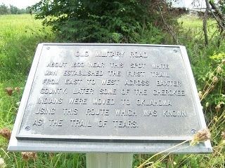
Old Military Road Marker
| On County Route 69 at County Route 55, on the right when traveling south on County Route 69. |
| On Hudson Road (U.S. 62) south of Rose Street, on the right when traveling north. |
| On Central Avenue (State Highway 72) near Main Street, on the right when traveling west. |
| On Military Park Road (County Road 65), on the left when traveling south. |
| Near Military Park Road (County Road 65). |
| On Jackson Place north of McClure Avenue (County Road 923), on the left when traveling north. |
| On Jackson Place at McClure Avenue, on the left when traveling north on Jackson Place. |
| On Jackson Place at McClure Avenue (Route 923), on the right when traveling north on Jackson Place. |
| On South Old Wire Road (County Road 83) 0.2 miles north of Dogwood Drive/Cross Hollows Road (County Road 1189), on the left when traveling north. |
| On South 1st Street north of West Elm Street, on the right when traveling north. |
| On West Ridge Avenue west of North Main Street (Business U.S. 65), on the left when traveling west. |
| On West Ridge Avenue at North Main Street (Business U.S. 65), on the left when traveling west on West Ridge Avenue. |
| On U.S. 412 at County Road 917, on the right when traveling north on U.S. 412. |
| On Main Street (State Highway 23) at Spring Street, on the right when traveling east on Main Street. |
| On Main Street (State Highway 23) south of Benton Street, on the left when traveling north. |
| On Spring Street at Hillside Avenue, on the right when traveling west on Spring Street. |
| On Main Street (State Highway 23) at Flint Street, on the right when traveling north on Main Street. |
| On Spring Street at Howell Avenue, on the right when traveling south on Spring Street. |
| On Main Street (State Highway 23) at Grand Avenue, on the right when traveling north on Main Street. |
| On Valley Street (U.S. 67) 0.1 miles south of Malvern Road, on the left when traveling south. |
| On Old Camden Road, 0.4 miles south of Marks Cemetery Road, on the right when traveling south. |
| On Old Camden Road, 0.4 miles south of Marks Cemetery Road, on the right when traveling south. |
| On Old Camden Road, 0.5 miles south of Marks Cemetery Road, on the left when traveling east. |
| On U.S. 371 at East Columbia Road (County Road 60), on the right when traveling north on U.S. 371. |
| On Main Street at South 3rd Street, on the right when traveling east on Main Street. |
| Near Arkansas Route 77 north of East Military Road, on the right when traveling south. |
| On East River Street east of South 1st Street, on the right when traveling east. |
| On Grand Promenade Trail, 0.2 miles south of Fountain Street, on the left when traveling south. |
| On Grand Promenade Trail, 0.6 miles south of Fountain Street, on the left when traveling south. |
| Near State Highway 46, 1.9 miles south of State Highway 291, on the right when traveling south. |
| On Midway Road (County Road 15) south of Jim Bray Drive (County Highway 628), on the right when traveling north. |
| On Walden Road north of White Drive (Arkansas Route 25), on the left when traveling north. |
| On South Drew Street at West Bradley Street, on the right when traveling south on South Drew Street. |
| On Arkansas Route 234 at County Road 133, on the right when traveling south on State Route 234. |
| On Ray Sowell Road at State Route 38, on the right when traveling west on Ray Sowell Road. |
| On County Road 201 south of State Highway 160, on the left when traveling south. |
| On State Highway 160, 0.4 miles east of County Road 4, on the right when traveling east. |
| On Indian Valley Road at Vaught Street, on the right when traveling east on Indian Valley Road. |
| On 2nd Street at East Ash Street, on the left when traveling north on 2nd Street. |
| Near Lock and Dam Road (Highway 7) west of Sheppard Drive. |
| On East Trickey Lane at Military Road, on the right when traveling east on East Trickey Lane. |
| Near East Trickey Lane at Military Road. |
| Near President Clinton Avenue. |
| Near Arkansas Route 166, 0.6 miles south of Arkansas Route 361 when traveling south. |
| On River Steet at South Market Street on River Steet. |
| On N. Main Street at W. South Street, on the right when traveling south on N. Main Street. |
| On U.S. 65 north of County Road 415, on the right when traveling south. |
| On Rogers Avenue east of 6th Street (Arkansas Highway 255), on the right when traveling east. |
| On Garrison Avenue at Towson Road, on the right when traveling west on Garrison Avenue. |
| On Garrison Avenue (U.S. 64) at North 2nd Street, on the right when traveling west on Garrison Avenue. |
| On Garrison Avenue at Towson Road, on the right when traveling west on Garrison Avenue. |
| On Old Military Road West (Arkansas Route 306) at South Main Street (Arkansas Route 1), on the left when traveling west on Old Military Road West. |
| On College Avenue (U.S. 71) at Center Street, on the right when traveling north on College Avenue. |
| On North Block Avenue, 0.1 miles south of West Dickson Street, on the left when traveling south. |
| On Arkansas Avenue north of Lafayette Street, in the median. |
| On Old Wire Road (State Highway 265) south of Dodd Avenue, on the right when traveling north. |
| On Mill Street at West Center, on the right when traveling south on Mill Street. |
| On Swinging Bridge Road east of Stoney Point Church Road, on the left when traveling east. |
| On East Woodruff Avenue at Spring Street, on the right when traveling south on East Woodruff Avenue. |
| On State Highway 22, 0.2 miles east of Delaware Bay Rd, on the right when traveling east. |
| On Union Street (Arkansas Route 27) west of North Front Street, on the right when traveling west. |