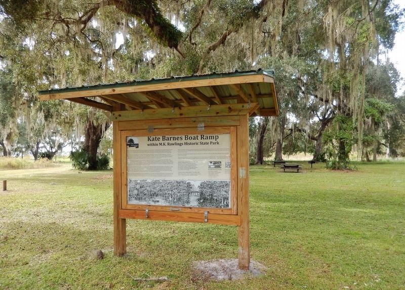
Marjorie Kinnan Rawlings described the nature and people of Cross Creek in vivid terms that have inspired artists and nature-lovers to cherish this place. One of Cross Creek's resident artists, Kate Barnes, attended a small neighborhood gathering . . . — — Map (db m187584) HM
The Alachua Sink, a named likely derived from the Potano word meaning “jug,” is the deepest of Paynes Prairie’s sinkholes and acts as a conduit for water entering the Floridan aquifer at a rate of up to 6 million gallons per day. . . . — — Map (db m126294) HM
The Boulware Springs Water Works Building is located directly adjacent to the brick reservoir for the springs, on a site of gently rolling to steep topography at the northern edge of Paynes Prairie.
Boulware Springs, free-flowing and . . . — — Map (db m70587) HM
This anchor was used on the Steamboat Chacala which carried passengers and freight over Paynes Prairie during the 1800’s. James Croxton of Micanopy was the builder and Captain.
Loaned by the Florida State Museum — — Map (db m175412) HM
Built in 1919 for the British Navy, this 170-foot steamer originally was christened Kilmarnock. Admiral Richard E. Byrd purchased the ship for use in his Antarctic expedition of 1928-30 and renamed her Eleanor Bolling in honor of . . . — — Map (db m73753) HM
Divers were limited to time and depth working underwater.
Dr. George Bond theorized that divers could stay underwater longer and dive to greater depths using saturation techniques breathing a controlled mixture of gas. These . . . — — Map (db m245046) HM
This Decompression Chamber was built in 1965 and is made of steel. The Chamber has skids and lifting eyes to secure it on a deck. The Chamber has all of the necessary pressure gauges, fittings, valves and portholes for adequately decompressing a . . . — — Map (db m245025) HM
Built as Perry Cubmarine PC3B in 1963. The Tech-diver can operate at a working depth of 600 ft for a 6 hour maximum dive duration. It is designed to carry a pilot and non-diving specialist for first-hand inspection and supervision of construction, . . . — — Map (db m245044) HM
Engineers and Scientists from the
“Navy Mine Defense Laboratory”
researched the problems of living at the bottom of
the sea with safety as paramount
The staff designed for:
• Primary and breathing gases
• Communication with . . . — — Map (db m245024) HM
Loftin’s Ferry, on Pitts Avenue, which later became Parker, was an important part of the major land route called the “Military Road” that ran from Apalachicola through St. Joseph to Marianna and beyond. This road, constructed from 1836 . . . — — Map (db m42114) HM
When the Lighthouse was moved to this site in 1894, the Head Keeper's cottage, the First Assistant Keeper's cottage, and one storage building were also moved. Soon after another storage building and a cottage for the Second Assistant Keeper were . . . — — Map (db m217571) HM
Originally constructed in 1868 overlooking the Cape Canaveral beach. Due to shoreline erosion, the lighthouse was dismantled and moved 1 ½ miles inland in the early 1890s. In July 1894, the light was relit at the new location. — — Map (db m23522) HM
On May 21, 1838, Florida territorial delegate Charles Downing requested a lighthouse be built on Cape Canaveral. The first lighthouse completed in Jan. 1848 stood 65-feet tall, had a 55-foot tower and a 10-foot lantern room equipped with 15 lamps on . . . — — Map (db m64798) HM
Port Canaveral is one of the busiest cruise ports in the world. Millions of passengers pass through the terminals every year on their way to relaxation and adventure. Some cruise liners are homeported here. For others, this is a port of call. . . . — — Map (db m164415) HM
Beginnings of Settlement
In the 1500s European explorers, slavers and missionaries first came to Cape Canaveral. Here they found a Native American population which had disappeared by 1730. The area remained sparsely populated until a . . . — — Map (db m217567) HM
Port Canaveral began as a small oil and fishing port. Today, the first-class, deep-water harbor can serve import, export and other industries. Through the years, generations of fishing families have taken their daily catch to market. Some of the . . . — — Map (db m164411) HM
There’s a strong military presence at the port. The Naval Ordnance Test Unit operates the Navy Port and ballistic missile submarines use the Trident Turning Basin for maintenance.
The U.S. Coast Guard, U.S. Air Force and Military Sealift . . . — — Map (db m164399) HM
1964 – First cruise ship visit, S/S Yarmouth
1980 – First Queen Elizabeth II visit
1982 – First Cruises to Nowhere, S/S Scandinavian Seas
1984 – First homeported ship, Premier Cruise Lines S/S . . . — — Map (db m59645) HM
1953 – Commercial fishing began
1954 – First oil imported for Central Florida power plants
1955 – First merchant ship, S/S Mormac Spruce arrived
1962 – First bulk cement silos built
1966 – First . . . — — Map (db m59647) HM
1961 – Freedom 7, First space capsule recovered through the Port
1989 – Foreign Trade Zone (FTZ) 136 activated
1989 – First quadramodal connection between sea, land, air and space
1992 – SPACEHAB, First FTZ . . . — — Map (db m59648) HM
North Side Development
1971 – Courageous, First Coast Guard Cutter, arrived
1974 – First warehouse built
2000 – Container Yard completed
South Side Development
1965 – First refrigerated . . . — — Map (db m59665) HM
1968 – Jetty Park Opened
1990 – Central Park (renamed Freddie Patrick Park) opened
1992 – First Florida deepwater port to develop an Inlet Management Plan
1995 – Malcolm E. McLouth Fishing Pier dedicated
1995 . . . — — Map (db m59666) HM
Port dedicated by U.S. Senator Spessard L. Holland. Serving on the Canaveral Port Authority Board of Commissioners: Colonel Noah Butt, Chairman; David S. Nisbet; L.M. Carpenter; A.A. Dunn and G.W. Laycock. N.M. Argabrite, Secretary. Barbara . . . — — Map (db m59729) HM
Florida’s largest lock connects the ocean to the Banana River. Ships, fishing and pleasure boats, barges and even space vehicles use Canaveral Lock to access the Port. Gates on the extra-wide lock open to adjust water levels. This ensures . . . — — Map (db m164418) HM
This anchor was discovered 16 miles off the shore of the Westgate Cocoa Beach Pier in 1984 by the late Keith Siegel, a famous local lobster diver, and his brother Brian.
Standing 10 ft. 5 in. tall and weighing more than 6,000 lbs., this artifact . . . — — Map (db m131824) HM
This anchor was discovered 16 miles off the shore of the Westgate Cocoa Beach Pier in 1984 by the late Keith Siegel, a famous local lobster diver, and his brother Brian.
Standing 10 ft, 5 in. tall and weighing more than 6,000 lbs. This artifact . . . — — Map (db m164170) HM
The Thousand Islands formed as the result of an ancient tidal inlet that breached this barrier island and flowed across modern-day Cocoa Beach. The indigenous Ais people, a fisher-gatherer society, lived along the inlet. Their oyster-shell middens . . . — — Map (db m112180) HM
Aaron Bennett established the Eau Gallie Yacht Basin in 1896. But even before that the basin was the terminus of a steamboat line in the days before the railroad reached Eau Gallie.
Phillip David Barbour, a native of Louisville, KY. was the man . . . — — Map (db m48984) HM
The Eau Gallie Yacht Club was completed in January, 1912, at a cost of $3,000. The officers of the club were George F. Paddison, President; Col. C. W. Fowler, Vice-President; J.E.M. Hodgson, Secretary and Treasurer. J.A. Carr was Commodore. The . . . — — Map (db m48987) HM
This house was built prior to 1900 by Gen. John B. Castleman, a veteran of the Civil War and the Spanish-American War. Gen. Castleman, from Louisville, KY., used this as his winter home for many years.
The General was active in political and . . . — — Map (db m235880) HM
A spur track for the Florida East Coast Railway was once located on the north side of this site. The track went out on a dock where freight and passengers were loaded onto river boats for the journey south.
In 1902, the East Coast Lumber and . . . — — Map (db m49042) HM
Descended from 17th Century New England pioneers, James Rossetter (1863-1921) was born in Hamilton County, Florida. Rossetter arrived in Eau Gallie in 1902 and became a leader in the local fishing industry, harvesting the many local waterways as a . . . — — Map (db m49214) HM
James Wadsworth Rossetter, Sr., came to Eau Gallie in 1902. He purchased this property in 1903. The house was built before the War Between the States and is on the former site of the Houston family's slave quarters. One member of that pioneer . . . — — Map (db m48975) HM
Constructed 1889
Restored 1985
Originally built by the Melbourne and Atlantic Railroad company, this pier was the gateway to the barrier island. A "Port Facility" for tourists, residents, freight, and mail, it supported a standard gauge . . . — — Map (db m53167) HM
One of the first homes in Melbourne Beach, the Ryckman House was built in 1890 for Jacob Fox by Captain Rufus W. Beaujean. Both men were original investors in the Melbourne Beach Company, later named the Melbourne Beach Improvement Company. The . . . — — Map (db m93164) HM
The last naval battle of the American Revolutionary War took place off the coast of Cape Canaveral on March 10, 1783. The fight began when three British ships sighted two Continental Navy ships, the Alliance commanded by Captain John Barry . . . — — Map (db m217593) HM
Edwin Dennis Sawyer (1874-1964) was born in the Bahamas, the second child of freed slave Alfred Sawyer. From age 18-25, Dennis worked on a ship and then in Ft. Pierce as a fisherman. In 1898, after moving to Cocoa, he married Rebecca Dallas. The . . . — — Map (db m192603) HM
Native Americans, explorers and settlers hauled or carried canoes and small boats over this narrow strip of land between Mosquito Lagoon and the Indian River. Eventually it became known as the “haulover.” Connecting both bodies of water . . . — — Map (db m108012) HM
Name Origin:
Named for two famous British ships of exploration in the 17th and 18th centuries.
Flight History:
First flight August 30, 1984. Discovery was NASA’s “workhorse shuttle’. During 39 missions, between 1984 and 2011, it spent a . . . — — Map (db m113074) HM
Arriving in 1885, the first railroad to Titusville was a 35-mile stretch of track from Enterprise on a line of the Jacksonville, Tampa, and Key West Railroad, the JT&KW. The tracks ran down the middle of Broad Street’s right-of-way, and out onto a . . . — — Map (db m112675) HM
George W. Scobie sailed his 50-foot oyster boat Sophie Fry to Titusville in 1885 and founded the Indian River commercial fishing industry. When rail service arrived, he began shipping large quantities of oysters and fish north. Before long, . . . — — Map (db m101409) HM
In 1911, Edgar W. Ellis and J. H. Beckwith put together a consortium of developers known as the Titusville Fruit and Farm Lands Company. They acquired 22,500 acres in the western portion of the old Delespine Grant with plans to drain marshland in . . . — — Map (db m50129) HM
Originally from Germany, Henry and Carolina met in New York. Henry traveled to Merritt Island with a friend in the early 1890's and cleared enough land to receive his Homestead Certificate in 1895. Henry built a small sailboat for living quarters . . . — — Map (db m195476) HM
Originally named by pirates who distilled rum on its shores, "Happy Creek" was a nearby inlet on North Merritt Island and home to Henry & Carolina Benecke who settled there in the early 1890's and raised six children. Henry was a hunting and fishing . . . — — Map (db m195986) HM
Not far from this spot lie the burned remains of the steamboat Pioneer, the first commercial passenger steamboat on the Indian River. The Pioneer was the flagship of Captain T.J. Lund’s Pioneer Steamboat Company, formed in the 1870’s . . . — — Map (db m112669) HM
This pier was the western end of Walker Bridge, the first bridge linking Titusville to Merritt Island. Built in 1922, the hand-cranked, wooden drawbridge served the area until preparations for a modern causeway began in the late 1930s. Causeway . . . — — Map (db m100950) HM
Lock No. 1, or Sewell Lock, was designed by world renowned engineers Major S. Sewell and Ben Johnson and built by the Furst-Clark Construction Company of Biltmore. It was part of the Everglades Drainage District and played a vital role in early . . . — — Map (db m100230) HM
Captain Joshua James embodies the courage and determination of 19th century lifesaving crews. Born in Hull, Massachusetts 1836, James lost his mother to shipwreck when he was just 10 years old. "Ever after," he was said to "scan the sea” in search . . . — — Map (db m212605) HM
Believed to be from the wreck of the British cartel ship "L'Athenaise" sunk Nov 1, 1804 with 179 French prisoners of war.
Found off Barefoot Mailman Hotel, Hillsboro Beach in 1967 by
Dr. Donald King
Bob Jordan
Mel Fisher
Rupert Gates . . . — — Map (db m127814) HM
During the devastating gale of November 25-26, 1888, Captain Joshua James led Hull's Massachusetts Humane Society volunteer lifesavers in the courageous rescue of 29 men from five ships. The volunteers faced the greatest danger while bringing eight . . . — — Map (db m212606) HM
In 1907, Edwin T. King, the town's first builder, a boatwright and an early citrus grower, built his third home on the south bank of the New River near what is now US 1. It remained the King family home until 1968. King's daughter Louise and her . . . — — Map (db m127492) HM
Philemon and Lucy Bryan's home was built in 1905 by contractor Edwin T. King at the request of their two sons, Reed and Tom. Philemon and Lucy first lived in a wood-frame house that had been converted into the Bryan Hotel. The New River Inn replaced . . . — — Map (db m127489) HM
Honeymooning here in 1948, Frank and Gertrude Denison purchased the shipyard on this site known as Dooley's Boat Basin, renaming it Broward Marine. In 1950, they won the contract to build 11 minesweepers for the Dutch and U.S. navies. The seemingly . . . — — Map (db m216301) HM
Robert "Bob" Rosioli moved to South Florida from Philadelphia, Pennsylvania, with his family in 1956. He started working in the Florida marine industry in 1962, when he took a position sanding boats at the Marine Ways boatyard in Fort Lauderdale. In . . . — — Map (db m216303) HM
In 1901, the U.S. Congress approved funding for a light near Hillsboro Point to fill a 90-mile void between the town of Jupiter and the Cape of Florida. Manufactured in Detroit, Michigan and reassembled at the Hillsboro Inlet in 1906. The . . . — — Map (db m172172) HM
This lighthouse is one of five skeletal cast-iron towers built by the Russel Wheel and Foundry Co. in Detroit, Michigan. The optical system was built in 1906 by Barbier Benard et Turren in Paris, France. Following its construction, the lighthouse . . . — — Map (db m127765) HM
One of the most historic locations in Pompano Beach, the Hillsboro inlet was given its name by surveyor William de Brahm in the early 1870's. The name honored British aristocrat Lord Wills Hill, the Earl of Hillsborough. It is not clear how the . . . — — Map (db m213478) HM
Side 1
Following the Civil War, a growing number of steamboats plied the waters of the Apalachicola River, busily transporting passengers, agricultural products and manufactured goods between the Gulf of Mexico and upstream locations in Florida, . . . — — Map (db m167156) HM
During the American Civil War in late 1863, Union forces and "refugee rangers" encountered local combatants in a brief skirmish on the eastern shore of the Myakka River near today's El Jobean. It is the only recorded Civil War skirmish within the . . . — — Map (db m151053) HM
American Merchant
Marine Veterans
Suncoast Chapter
Dedicated to the
six thousand eight hundred
and thirty-four
Merchant Seamen who lost
their lives in World War II — — Map (db m243905) WM
On this site, in 1887, ended the southernmost railroad trackage in the U.S. Florida Southern Railway's narrow-gauge tracks ran out on a 4,000 foot "Long Dock," where connections were made to New Orleans, Key West, and Havana steamers of the Morgan . . . — — Map (db m167520) HM
A Man-made Lake Felburn Park was once a mine. Workers mined dolomite rock, which was added to soil on farms. As they dug, miners hit a reservoir of groundwater, and the spring water started to fill the pit. They pumped out the water as it . . . — — Map (db m167344) HM
The Price of Progress Picture massive barges, tugboats and trawlers clogging the bay. This was to be the west end of the Cross Florida Barge Canal, where the water enters the Gulf of Mexico. The canal would have impacted Florida's fresh and . . . — — Map (db m167343) HM
A Rocky Past Today, the old railroad bed beneath the Dunnellon Trail carries walkers and bicyclists. In the late 1800s, it moved train cars laden with phosphate rock. Prospectors discovered the valuable mineral here in 1889, sparking an . . . — — Map (db m167502) HM
(Side 1)
The area containing present day Floral City has been inhabited by
humans for thousands of years. When Hernando De Soto came through
the area in 1539, he found the Indian village of Tocaste. From the late
1700s until the Second . . . — — Map (db m104967) HM
This two story wood frame Colonial Revival style residence features a beautiful verandah best suited for socializing on warm summer evenings was built in 1903, by James Keels Kelley. According to a 1936 Citrus County Chronicle article, J.K. Kelley . . . — — Map (db m126053) HM
The LARC-LX (Lighter Amphibious Resupply Cargo-60 Ton) is a welded steel hull amphibious vehicle. It can carry up to 100 tons of cargo or 200 personnel. It is powered by four 265hp diesel engines each driving one wheel. The engines can be coupled . . . — — Map (db m181365) HM
Beginning in 1970, members of Lynyrd Skynyrd made Rock 'n Roll history on this site, where they wrote and perfected many of their hit songs. In the late 1960's, before becoming world famous, the long haired Skynyrd boys from the Westside of . . . — — Map (db m235213) HM
Was a six-wheel drive semi-amphibious off-road vehicle originally developed for use by the US Military in the Vietnam War. The Goat used an articulated chassis, so that from distance it appears to be a four-wheel trailer, but it is a single . . . — — Map (db m181368) HM
Samuel B. Thompson owned and operated
dock and warehouses at the foot of
Thompson St. (now Wharf St., name changed
about 1951). Thompson's warehouses were
burned by Union soldiers in 1864.
After the Civil War, Albert S. Chalker
operated . . . — — Map (db m70285) HM
Hours: April to November 9:00-4:4:30
November to April 8:00 -4:30
Come upstairs to the National Park visitor center for information, park maps, exhibits, videos and more!
Along
The Tamiami Trail
Things to see and do (From West to . . . — — Map (db m106245) HM
This "Back Bay" area was settled in 1915. As Naples' first sheltered mooring, it became the community center for the pioneers building the Tamiami Trail as well as the fishing industry. The first pharmacy, the first newspaper, and all the important . . . — — Map (db m127760) HM
The Naples Canal was a monumental prehistoric construction achievement. It was 4,150 feet long (0.8 miles) and bisected an area between the Gulf of Mexico and Naples Bay. The Naples Canal was dug perhaps as early as A.D. 200 by local American . . . — — Map (db m127697) HM
Built in 1888 as a freight and passenger dock, the Naples Pier stands as a community landmark. Narrow gauge train rails spanning the length of the pier transported freight and baggage in the early 1900’s. Part of the structure as well as the post . . . — — Map (db m92802) HM
Bald cypress, the swamp and wood storks make this National Audubon Society sanctuary unique. The source of storks Wood storks come to Corkscrew Swamp during the dry months of winter and early spring. Here, in greater numbers than anywhere . . . — — Map (db m164800) HM
Imagine alligator relatives dating back to the days of dinosaurs, over 150 million years ago. Gators today still look similar to their 50 foot long relatives. Present day American alligators can grow to over 15 feet and many weigh up to 1,000 . . . — — Map (db m106227) HM
Rain-the Swamp's Lifeblood
Nearly 55 inches of rain falls here annually-drenching Big Cypress National Preserve during the summer wet season.
The fresh water flowing through the national preserve replenishes the local aquifer and sustains . . . — — Map (db m106230) HM
The watery forest was born from a slow-moving creek whose waters rise and fall year after year, flooding the shallow banks and then withdrawing.
Here brown waters reflect the tall trees, Spanish-moss and clouds in the sky. Alligators, birds and . . . — — Map (db m100647)
Wildlife & You How you behave can save The thrill of watching an animal in it native surroundings can be spectacular and awe inspiring. The memories made while experiencing such events can last a lifetime, and so can your actions.While visiting . . . — — Map (db m106229)
Captain Francis Langhorne Dade, U.S. Army and his 120-man Companies A,B,D,H and N, built Fort Duval in November 1826 at the mouth of the Suwannee River. The structure was 140 by 130 feet and six feet high with portholes for firing. The fort was . . . — — Map (db m167492) HM
Captain Frederick W. Bruce, for whom Bruce Park is named, was born in New Hampshire in 1856. In 1869 young Bruce was sent to live with his uncle Elisha Bruce in St. Augustine, Florida, but that same year, at age 13, ran away to sea, an adventure . . . — — Map (db m93090) HM
Tomb
In Memory of my
shipmates of the
Confederate
Torpedo Boat David
Charleston S.C. Oct 5, 1863
Lieut. W.T. Glassell, C.S.N.
Pilot W.J. Cannon, C.S.N.
Fireman Jas.Sullivan, C.S.N.
Chief Engineer
James . . . — — Map (db m57587) HM
(side 1)
Pilot Town
The St. Johns River provided trade access that supported the economy of the Fort George Island plantations. Cotton and sugar from the plantations were transported on the river to trading posts. Early Spanish . . . — — Map (db m106389) HM
English:
Once the Portuguese made successful transatlantic trading voyages, other European nations quickly followed. In the eighteenth century, the port of Nantes became the busiest French port involved in the European slave trade . . . — — Map (db m145391) HM
English:
Slavery has been a component of human history through time. Whether captured, purchased, or taken as spoils of war, enslaved people had wide-ranging experiences, but they all shared one thing in common: loss of freedom. . . . — — Map (db m145392) HM
Where there is now a tranquil river scene, a dock hustled and bustled with activity during the plantation era. Cotton bales were sent to market, and slaves and finished goods were brought here by boat.
Most plantations were located along . . . — — Map (db m145388) HM
The McCoys Creek Improvement Project was a civic and transportation plan developed by Jacksonville City Engineer Joseph E. Craig in 1928. At the time, the McCoys Creek area was a breeding ground for mosquito-borne illnesses. Developed to reduce . . . — — Map (db m229765) HM
A luxury passenger liner before the Civil War, the Maple Leaf was pressed into service as a Union transport ship in 1862. The sidewheel steamship was sunk in the St. Johns River by a submerged Confederate mine on April 1, 1864 at . . . — — Map (db m171599) HM
The American Rivers Initiative gives special recognition to outstanding stretches of America’s rivers to further three objectives: natural resource and environmental protection, economic revitalization, and historic and cultural preservation. The . . . — — Map (db m171601) HM
Ferry service from Jacksonville and Arlington began in 1914 and was Sponsored by the Alderman Company. The service gave access to 1,100 acres of plantation land bought and subdivided by the company in 1913 and provided the impetus for growth and . . . — — Map (db m173403) HM
To the memory of all sailors who served aboard the Destroyer USS Frank E. Evans DD754 May we never forget the ship The crews who proudly sailed Her and those who paid the ultimate price while serving their country {Back} Some . . . — — Map (db m239889) HM WM
Approximately 15 miles up river from this point, the Union transport Maple Leaf was destroyed by a Confederate mine during the early morning hours of April 1, 1864. The Maple Leaf sank to the bottom of the St. Johns River after hitting . . . — — Map (db m58347) HM
(side 1)
Discovered by Juan Bono Quexos, 1520 • First named Rio de Corrientes by Spain • Explored by Pedro Menendez • Called Riviere de Mai by France, 1562-4 • San Mateo, Salamototo and Picolata were among its other Spanish names • Its . . . — — Map (db m129642) HM
600 entries matched your criteria. The first 100 are listed above. Next 100 ⊳