On NC Highway 49, on the left when traveling north.
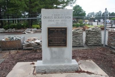
Charles Richard Drew
1904 - 1950
Black scientist and surgeon
Pioneer in the preservation of blood plasma
Medical director of the Blood-for-Britain Project, 1940
Director of the first American Red Cross Blood Bank, 1941 . . . — — Map (db m31142) HM
Near North Carolina Route 62 at Kimesville Road (County Route 1113), on the right when traveling west.
1693 acre grain plantation founded by Michael Holt III (1778-1842). Birthplace of E.M. Holt (1807-1884), a founder of the southern textile industry and developer of "Alamance Plaid" fabrics. Dr. William Rainey Holt (1798-1868), noted "scientific . . . — — Map (db m222728) HM
On North NC Highway 49, on the left when traveling north.
Side A Pleasant Grove High School was built on this site in 1922 to serve grades 8 - 10 from 5 small schools in the Pleasant Grove township and one from the Faucette township; Mahan, Sidney, King, Squires, and McCray. Brogden Tew was the . . . — — Map (db m31151) HM
On North Carolina Route 62 south of Louis Graham Road, on the left when traveling north.
One-room school built for Black children in 1915-16. In continuous operation until 1951 when four rural schoolhouses were consolidated into Pleasant Grove School. — — Map (db m224338) HM
On North Carolina Route 62 south of Louis Graham Road, on the left when traveling north.
The McCray School, built in 1915-16, is a rare example of early twentieth century one-room schools for Black children in rural Alamance County. Land for the school was donated by Albert Graham (1836-1916). Construction was completed by Andrew Nash, . . . — — Map (db m224339) HM
On Glencoe Street, on the left when traveling west.
African Americans experienced the textile mill world very differently than white families. Mills did not offer the same work opportunities to black men and women as they did for whites. Life in the mill village was also restricted, and black workers . . . — — Map (db m222732) HM
On Main Street, on the right when traveling north.
Racial violence in Caswell and Alamance counties in 1870 led to martial law, under Col. Geo. W. Kirk, impeachment & removal of Gov. W.W. Holden. — — Map (db m28308) HM
On Main Street (U.S. 52) at Cemetery Street, on the right when traveling south on Main Street.
Free black served as a Baptist pastor at Rocky River Church until law in 1831 barred blacks from public preaching. Buried 500 yards west. — — Map (db m77358) HM
On Route 74 at South Main Street, on the right when traveling east on Route 74.
Anson County Training School
1920-1960
A facility for education
of children of color.
Woodlawn School
1960-1961
J.R. Faison School
1961-1985 — — Map (db m94987) HM
On North Greene Street (North Carolina Route 109) just north of West Wade Street, on the left when traveling north.
Fulton Allen, better known as blues singer and guitarist Blind Boy Fuller, lost his vision totally in 1927 and had as his only means of support the occasional income from playing guitar. He listened carefully to phonograph records of such popular . . . — — Map (db m244602) HM
On Blue Ridge Parkway (at milepost 266.8), on the right when traveling south.
Mount Jefferson looms high over the town of Jefferson for which it is named. It was formerly called Negro Mountain because run-away slaves supposedly hid out there while fleeing north. The summit and slopes of the mountain now make up Mount . . . — — Map (db m140555) HM
On Front Street near King Street, on the right when traveling south.
This site marks the former location of the Bath African Methodist Episcopal Zion Church. The AME Zion denomination, chartered in New York City in 1801, began in the 1790s when discrimination against African American Christians forced them to . . . — — Map (db m65673) HM
On West Main Street at Gladden Street, on the left when traveling east on West Main Street.
Prior to formation of 1st N.C. Colored Volunteers, about 100 black men were armed to aid Union forces during the siege of Washington in 1863. — — Map (db m114466) HM
On West Stewart Parkway just south of West Main Street, on the right when traveling south.
In 1830 talented shipwright and freed slave Hull Anderson built a prosperous shipyard three blocks west of here, before moving to Liberia. — — Map (db m224083) HM
On East Main Street, 0.1 miles east of North Charlotte Street, on the left when traveling east.
Though officially names Windmill Creek, waterway is better known by a name of African American man who lived by early Windmill. — — Map (db m226307) HM
On South Queen Street south of West Water Street when traveling south.
Windsor's residents slept peacefully the night of January 29-30, 1864, unaware of what the morning would bring, as U.S. Navy Lt. Cmdr. Charles W. Flusser led three gunboats their way to disrupt Confederate recruiting efforts. USS Massasoit . . . — — Map (db m226118) HM
Near South Market Street north of Eagle Street, on the right when traveling south.
Eagle Street traditionally has been the commercial, cultural, and professional center of the African-American community. The YMI Cultural Center, commissioned by George W. Vanderbilt in 1892 as the Young Men's Institute, was renovated in the 1980s. . . . — — Map (db m98367) HM
On Broadway at Mt. Clare Avenue, on the right when traveling north on Broadway.
Gen. Davis Tillson raised 1,700-man 1st U.S. Colored Heavy Artillery in Tennessee and North Carolina in 1864. The unit encamped nearby while garrisoned in Asheville in 1865. Assigned to Tillson's 2nd brigade, the men participated in operations in . . . — — Map (db m55571) HM
On Biltmore Avenue (U.S. 25) at Eagle Street, on the right when traveling north on Biltmore Avenue.
Building the Block
Gateway to Community
As you turn down Eagle Street, you'll find yourself in The Block. This revitalizing district was crucial to the culture, economy and history of Asheville's African American community for more . . . — — Map (db m209942) HM
Near Eagle Street at Davidson Drive, on the right when traveling east.
When the war began, more than 15 percent of Buncombe County’s residents were enslaved people. James Patton housed slaves behind his Eagle Hotel (straight ahead), where they worked as waiter, maids, grooms, cooks, and trail guides. Three blocks to . . . — — Map (db m75507) HM
Near South Market Street north of Eagle Street, on the right when traveling south.
James Vester Miller was chief brickmason for the 1925 Municipal Building. The cornucopias over the side doorway mark the entrance to the City Market, located there from 1926 to 1932. Of slave parentage, Miller achieved renown as a craftsman, . . . — — Map (db m98368) HM
On South Market Street south of Sycamore Street, on the right when traveling south.
Asheville's first official school building for black children, built in 1892. Destroyed by fire in the great tragedy of 1917, seven students died. In 1922 the famous Stephen's Lee High School was erected in it's place, becoming a beacon for black . . . — — Map (db m209939) HM
On South Market Street south of Sycamore Street, on the right when traveling south.
Here, on this ground, community grew like a garden. Paving a way for economic freedom, newly emancipated Isaac and Delia Dickson (pictured at right w/ horse), worked, saved, & bought several tracts of land on Valley Street where they rented homes to . . . — — Map (db m209940) HM
On South Market Street at Beaumont Street, on the right when traveling north on South Market Street.
After the end of the Civil War, Black people began establishing enterprises in Asheville. Isaac Dickson's investments sparked a thriving business district and neighborhood that stretched from Eagle and Market streets into the present-day East . . . — — Map (db m240092) HM
On South Market Street at Sycamore Street, on the right when traveling south on South Market Street.
Lynching in America
Between 1865 and 1950, thousands of African Americans were victims of mob violence and racial terror lynching across the United States. Following the Civil War, white Southerners fiercely resisted equal rights for African . . . — — Map (db m236892) HM
On Craven Street at Emma Road (County Road 1338), on the left when traveling east on Craven Street.
Lynching in America
Between 1865 and 1950, white mobs lynched thousands of African Americans across the U.S. Following the Civil War, white Southerners fiercely resisted equal rights for African Americans and sought to uphold an ideology of . . . — — Map (db m204979) HM
On College Street (Alternate U.S. 74) at South Spruce Street, on the right when traveling east on College Street.
Lynching in America
Thousands of Black people were the victims of racial terror lynching in the United States between 1865 and 1950. After the Civil War, the 13th, 14th, and 15th Amendments to the U.S. Constitution ended slavery and extended . . . — — Map (db m205149) HM
Near Dalton Street, 0.3 miles north of Wyoming Road, on the right when traveling north.
George Avery, a 19-year-old enslaved blacksmith, joined Co. D, 40th United States Colored Troops, in Greeneville, Tennessee, in 1865. According to local tradition, his master, Confederate Maj. William W. McDowell, sent Avery to enlist for a post-war . . . — — Map (db m75527) HM
Near Victoria Road, 0.1 miles south of Oakland Road, on the right when traveling south.
After John Brown’s raid on Harpers Ferry, Virginia, in 1859, new militia companies were formed in the South. Businessman William W. McDowell, whose wife acquired this house from her father’s and brother’s estates, raised a company called the . . . — — Map (db m75524) HM
On S. Market St. at Patton Ave. (U.S. 74) on S. Market St..
Est. 1892 as a center for social, moral, religious influence for blacks working at Biltmore. Businesses thrived in building 100 yards, S. — — Map (db m30151) HM
On Sutton Avenue at Cherry Street, on the right when traveling east on Sutton Avenue.
"My father lived and breathed Southern Railways. He would take us to the Black Mountain Train Depot and the Swannanoa Tunnel to watch the trains go by. I remember him saying, "I've walked track through these tunnels many a day."
Leslie Allen . . . — — Map (db m176984) HM
Black Mountain's original depot was rebuilt in 1898 and rebuilt again, for the final time in 1909.
This depot still stands here today and conformed to plans from the Southern Railway's Washington office, which mandated two waiting rooms, one . . . — — Map (db m176985) HM
In an effort to save money, the track to Black Mountain was laid by convicts leased from the state. It cost 30 cents per day to house an inmate, whereas a free laborer made about $1.00 a day.
More than 500 convicts at a time, primarily . . . — — Map (db m179638) HM
On West McDowell Street north of South College Street, on the right when traveling north.
Morganton native Etta Lucille Baker, starting at the age of three, played the Piedmont Blues for ninety years. Taught by her father Boone Reid, she first recorded “One Dime Blues” in 1956. At the height of the folk music revival during the 1950's . . . — — Map (db m210389) HM
On West Concord Street west of South Anderson Street, on the right when traveling east.
Morganton's oldest intact historically Black neighborhood. Home to prominent citizens of the era, it is distinguished by the vernacular style of the homes and rural character of the landscape. — — Map (db m210386) HM
On East Union Street (Business U.S. 70) north of Bouchelle Street, on the right.
Black mothers led fight
for equality in education
Organized meetings and
demonstrations here, 1961.
Inspired nonviolent change. — — Map (db m240443) HM
On Cabarrus Avenue W (State Highway 1002) east of Crowell Drive SW.
Presbyterian. Est. 1867 by Luke Dorland to educate Negro women, Scotia Seminary merged in 1930 with Barber Memorial Institute. Coed since 1954. — — Map (db m43383) HM
On Union Street South just north of Means Avenue Southeast, on the right when traveling south.
In the last quarrter of the nineteenth century, many cotton mills were operating in Concord providing employment for great numbers of local citizens while swelling the population. The above is a tribute to Gibson, Coleman, and Odell mills.
The . . . — — Map (db m175761) HM
On Union Street South just north of Means Avenue Southeast, on the right when traveling south.
The above images give tribute to Scotia Seminary, which was founded in 1867 on Depot Street for the education for young African American women. The first building at Scotia was the top image, a simple white siding structure. The lower images . . . — — Map (db m175760) HM
On Wade Street at C Street, on the right when traveling west on Wade Street.
Congregation established 1900
Building erected between 1918-1921
Placed on the
National Register of Historic Places
by the United States
Department of the Interior
January 9, 1986 — — Map (db m238046) HM
On Highway 343, 0.1 miles north of Bunker Hill Road (State Highway 1217), on the right when traveling north.
This location is the site of the original "McBride Colored School". The school was erected in 1926 during the era of segregation in the rural South for the education of African American children grades 1-12.
Julius Rosenwald and Booker T. . . . — — Map (db m211237) HM
On Frontage Street (Front Street) near Gordon Street (Local Highway 1312), on the right when traveling west.
In loving memory and recognition
Menhaden Fishermen Past — Present — Future
This is their livelihood, this is their life — they know the sea, can read God’s weather chart: sun, moon, and stars from memory. The compass points are there . . . — — Map (db m226093) HM
On Front Street at Orange Street, on the right when traveling east on Front Street.
Beaufort, North Carolina, was involved in the Trans-Atlantic human trade and is a documented Middle Passage arrival site.
Enslaved people disembarked at or neat this exact location, now called Topsail Park. Records from 1769 show that one . . . — — Map (db m226078) HM
On U.S. 70 west of Horsehoe Road, on the right when traveling west.
Davis was first settled by four families in the early 1700s. Though the main occupations were a combination of farming and fishing its fame was its waterfowl legacy.
Waterfowl meat was in demand in urban America and supplied by market hunters. . . . — — Map (db m226096) HM
The Middle Passage, part of a larger trade route known as the Triangular Trade, is the route which was used in the trafficking of captive Africans across the Atlantic Ocean to the Americas.
From the 16th to the 19th centuries, approximately 12 . . . — — Map (db m241337) HM
On Blanch Road (State Highway 1523) at Bertha Wilson Road (State Highway 1511), on the left when traveling north on Blanch Road.
In 1850s on a farm in this area Abisha Slade perfected a process for curing yellow tobacco. His slave Stephen discovered process in 1839. — — Map (db m216370) HM
On Broad Street (State Highway 57) just east of Palmers Alley, on the right when traveling east.
Built for Jarvis Friou a French Huguenot and prominent businessman. A Federal style house with an added Victorian style ornate bracketed porch. Original to the house is the beautiful red Venetian glass transom and interior woodwork attributed to . . . — — Map (db m220874) HM
On Broad Street (Highway 57) just east of Liberty Street, on the right when traveling west.
Barrels called Hogsheads were "prized," or filled, with tobacco or flour, rolled down to the Dan River and shipped on "Batteaux," which were flat-bottomed boats. Men who made hogsheads were called "Coopers."
This display is in honor of William . . . — — Map (db m171776) HM
On 7th Avenue Southwest at 3rd Street SW, on the right when traveling east on 7th Avenue Southwest.
Constructed in 1935 to serve African-American students in Hickory. With desegregation of Hickory Schools, Ridgeview High School classes ceased in 1966; Ridgeview School closed in 1973. — — Map (db m235000) HM
On East D Street (State Road 10/16) at South Ervin Avenue, on the right when traveling west on East D Street.
African-American high school grew out of an
1899 one-room schoolhouse. In 1924 the school
was enlarged and named Snow Hill Graded
School. Grades 8 & 9 were added in 1934, and
it became a full high school in 1936, renamed
Central High School. In . . . — — Map (db m240701) HM
On South Street north of East Chatham Street when traveling north.
Lynching in America Thousands of Black people were victims of lynching in the United States between 1865 and 1950. After the Civil War, violent resistance to equal rights for Black people and an ideology of white supremacy led to fatal . . . — — Map (db m233991) HM
On East Gale Street east of North Broad Street (State Highway 32), on the left when traveling east.
A Gothic Revival style church built by Hannibal Badham Jr. a member of the famous Edenton Badham family of carpenters. Notable contributors to Edenton's architectural heritage, revere such famous names as Joe Welcome (1774-1859) and three . . . — — Map (db m225361) HM
On Court Street just north of East King Street, on the left when traveling north.
Jailhouse History The original Edenton jail was built in 1722 when the town incorporated. The present jail is the county's fifth. Ebenezer Paine constructed it in 1825, probably using 1773 plans by John Hawks, architect of . . . — — Map (db m224498) HM
On Court Street just north of East King Street, on the left when traveling north.
Methods of Punishment Punishment in the colonial era focused on public humiliation by forcing the guilty party to spend time in the stocks or pillory. The stocks restrained the feet and the pillory secured the head and hands, . . . — — Map (db m224461) HM
On North Broad Street (North Carolina Route 32) just south of Park Avenue, on the left when traveling south.
In December 1962, Dr. Martin Luther King, Jr. visited northeastern North Carolina. Arriving in Elizabeth City, the president of the Southern Christian Leadership Conference spoke at African American churches there and in Hertford en route to Chowan . . . — — Map (db m224286) HM
On South Broad Street at East Water Street on South Broad Street.
Now one of Edenton's most tranquil locations, during the antebellum period Edenton harbor was the town's industrial center with wharves, shipyards, and maritime activity.
North Carolina's small, ill-protected harbors prevented development of . . . — — Map (db m34770) HM
On South Broad Street north of East Water Street, on the right when traveling north.
A Brief History of Josephine Leary, Entrepreneur
1856: Josephine Napoleon Williams was born in to slavery. Following the Civil War, freed when she was 9 years old.
1873: Josephine Williams marries Sweety Archer Leary, both worked as . . . — — Map (db m181668) HM
On Virginia Road (North Carolina Route 32) at Luke Street, on the right when traveling west on Virginia Road.
Julius Rosenwald and Booker T. Washington established fund in 1912 to provide grants to African American communities to improve education. In N.C. the fund assisted with 817 projects in 93 counties. The first one was Warren Grove School, a . . . — — Map (db m225206) HM
Near South Broad Street south of West King Street, on the right when traveling south.
This location in the back garden may well be the site of the original kitchen as outlined above in the Sanborn Five Insurance Map of 1883. An excellent example of a surviving 18th century kitchen is found at Somerset Place, across Albemarle Sound . . . — — Map (db m226115) HM
On CV Alexander Drive (County Route 1189) at Lincoln Academy Road, on the right when traveling east on CV Alexander Drive.
Founder: Emily Pruden, educator and philanthropist from Orange, Connecticut. A co-educational boarding and day school, grades 1-12, for children of African descent. Accredited 1923. Home of Mildred Wellmon Elementary School, a historic Rosenwald . . . — — Map (db m108710) HM
On West Warren Street just east of South Trade Street, on the left when traveling west.
Bobby Bell is a Shelby native who played professional football in the AFL/NFL for the Kansas City Chiefs for 12 years. He is a member of the Pro Football Hall of Fame, the College Football Hall of Fame, and was a member of the Chiefs' team that won . . . — — Map (db m199338) HM
On East Warren Street east of South Dale Street, on the right when traveling east.
African Americans, led by local high school students, held sit-ins and picketed businesses in Feb. 1960 to demand desegregation. — — Map (db m196330) HM
On Queen Street at Pasteur Street, on the left when traveling east on Queen Street.
The first African-American Presbyterian Church in the Craven County area founded in 1880, ½ block north of here on Pasteur Street destroyed by the “Great Fire of 1922” rebuilt in 1924 at 720 Bern StreetThe Honorable George H. White, First Clerk of . . . — — Map (db m222495) HM
On Cypress Street at Smith Street, on the right when traveling west on Cypress Street.
Greenwood Cemetery, established in 1882 on the grounds of an earlier cemetery, is New Bern’s second-oldest public cemetery and the first city-owned cemetery for African Americans. Thirteen grave markers are dated between 1816 and 1859. At least . . . — — Map (db m76972) HM
On Broad Street (U.S. 17) at George Street, on the right when traveling west on Broad Street.
Asst. Superintendent Public Instruction, 1868-70; a founder Livingstone College, 1885; Bishop A.M.E. Zion Church; founded St. Peters, 1864. One blk. N. — — Map (db m24053) HM
On National Avenue at Court Street, on the right when traveling south on National Avenue.
On March 14, 1862, Union Gen. Ambrose E. Burnside captured New Bern after seizing Roanoke Island in February and moving his army inland. After the battle for the town, the Federals established hospitals in the New Bern Academy, the Masonic Lodge, . . . — — Map (db m76946) HM
During the Civil War, thousands of enslaved blacks freed themselves by escaping to Union lines. Craven County native William Henry Singleton (1843-1938) was one of them. According to his biography, Recollections of My Slavery Days (1922), as . . . — — Map (db m24054) HM
Muslim slave & scholar. African born, he penned autobiography in Arabic. 1831. Lived in a Bladen County and worshipped with local Presbyterians. — — Map (db m94902) HM
On Courthouse Road (State Highway 1242) near Caratoke Highway (State Highway 168), on the right when traveling north.
Currituck has been the county government seat since 1723. The core of the present courthouse to the right and jail in front of you were here when the Civil War began. On March 31, 1862, the “Currituck Light Cavalry” began enlisting on . . . — — Map (db m2764) HM
Near Museum Drive, 0.2 miles west of Coast Guard Drive.
Side A:Flagship USS MinnesotaUSS Minnesota, a wooden steam frigate built in 1855, was the flagship for the Atlantic Blockading Squadron commanded by Flag Officer Silas H. Stringham. Seven United States Navy warships bombarded Forts . . . — — Map (db m46190) HM
Near Fort Raleigh Road, 0.3 miles north of U.S. 64.
In the 1860s - more than two and a half centuries after the disappearance of the 1587 settlers, a new colony was taking shape on Roanoke Island, one that was home to refugees fleeing the bondage of slavery. The island south and west of here became a . . . — — Map (db m233626) HM
Near Fort Raleigh Road, 0.3 miles north of U.S. 64.
Despite dissolving only five years after the first individuals arrived, the Roanoke Freedmen's Colony was one of the first steps in a long struggle for racial equality in the United States. Community members fought for their freedom through . . . — — Map (db m233628) HM
On Freedman's Colony Road near U.S. 64/264, on the right when traveling west. Reported permanently removed.
and they made their lives
bitter with hard bondage
Exodus 1:14
For the millions of immigrants to this land, America has not been so much a destination as a promise: a promise of equality, a promise of . . . — — Map (db m9670) HM
Near Visitors Center Circle near Virginia Dare Memorial Bridge (Bypass U.S. 64), on the left when traveling west.
This marker recognizes the final resting place of Spencer Bowser, the patriarch of a prominent African American family in North Carolina. Also buried here are several other members of the Bowser family, including J.P. Bowser, Lloyd B. Bowser, Q.B. . . . — — Map (db m57026) HM
On Freedman's Colony Road near U.S. 64/264, on the right when traveling west. Reported permanently removed.
Thus saith the Lord,
Let my people go.
Exodus 8:1
The bloodbath called the Civil War had begun and would cost the lives of over 600,000 Americans. As the Union armies advanced south, refugee . . . — — Map (db m9669) HM
[obverse:]First Light of Freedom Former slaves give thanks by the creek’s edge
at the sight of the island - “If you can cross the creek to Roanoke Island, you will find ‘safe haven’.” [rendering of Edwin Forbes' "The . . . — — Map (db m46990) HM
On Freedman's Colony Road near U.S. 64/264, on the right when traveling west. Reported permanently removed.
I have caused thee to see it
with thine eyes,
but thou shalt not go over thither.
Deuteronomy 34:4
The Proclamation of Emancipation gave the military authority to enlist “Such persons of suitable condition…into . . . — — Map (db m9671) HM
Located south of Oregon Inlet, Lifesaving Station Pea Island was the only unit in the history of the Coast Guard manned by all Black crews. This marker is dedicated to the crews of Pea Island who risked their lives and endured so that others might . . . — — Map (db m48610) HM
On East 1st Street at North Salisbury Street, on the right when traveling west on East 1st Street.
St. Stephen has and continues to serve
the African American community
to eliminate social injustices,
promote civil rights and save souls.
National Historic Registry
August 6. 2021 — — Map (db m239034) HM
On Fayetteville Street at Massey Avenue, on the right when traveling south on Fayetteville Street.
Est. in 1922 by African Americans. Hosted many American Tennis Assoc. tournaments. Durham Committee on Negro Affairs org. here, 1935. — — Map (db m210852) HM
443 entries matched your criteria. The first 100 are listed above. Next 100 ⊳