After filtering for North Carolina, 443 entries match your criteria. The first 100 are listed. ⊳
African Americans Topic
By Patrick G. Jordan, May 22, 2010
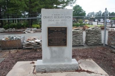
Charles Richard Drew Marker
| 1 ► North Carolina, Alamance County, Burlington — Charles Richard Drew — 1904 - 1950 — |
| On NC Highway 49, on the left when traveling north. | |||
| 2 ► North Carolina, Alamance County, Burlington — McCray School — |
| On North Carolina 62, 0.2 miles south of Louis Graham Road (SR 1757) when traveling north. | |||
| 3 ► North Carolina, Alamance County, Burlington — Oak Grove Plantation — 1790-1910 — |
| Near North Carolina Route 62 at Kimesville Road (County Route 1113), on the right when traveling west. | |||
| 4 ► North Carolina, Alamance County, Burlington — Pleasant Grove High School — 1922 - 1971 — |
| On North NC Highway 49, on the left when traveling north. | |||
| 5 ► North Carolina, Alamance County, Burlington — The McCray School — |
| On North Carolina Route 62 south of Louis Graham Road, on the left when traveling north. | |||
| 6 ► North Carolina, Alamance County, Burlington — The McCray School — |
| On North Carolina Route 62 south of Louis Graham Road, on the left when traveling north. | |||
| 7 ► North Carolina, Alamance County, Burlington, Glencoe Village — African Americans in the Mill Village — |
| On Glencoe Street, on the left when traveling west. | |||
| 8 ► North Carolina, Alamance County, Graham — G-120 — Kirk-Holden War — |
| On Main Street, on the right when traveling north. | |||
| 9 ► North Carolina, Anson County, Ansonville — K-57 — Ralf Freeman — |
| On Main Street (U.S. 52) at Cemetery Street, on the right when traveling south on Main Street. | |||
| 10 ► North Carolina, Anson County, Wadesboro — Anson County Training School — |
| On Route 74 at South Main Street, on the right when traveling east on Route 74. | |||
| 11 ► North Carolina, Anson County, Wadesboro — Blind Boy Fuller — Born: July 10, 1904, Wadesboro, NC Died: February 13, 1941, Durham, NC — NC Musicians Mural Trail — |
| On North Greene Street (North Carolina Route 109) just north of West Wade Street, on the left when traveling north. | |||
| 12 ► North Carolina, Ashe County, West Jefferson — Mt. Jefferson — |
| On Blue Ridge Parkway (at milepost 266.8), on the right when traveling south. | |||
| 13 ► North Carolina, Beaufort County, Bath — Bath African Methodist Episcopal Zion Church — |
| On Front Street near King Street, on the right when traveling south. | |||
| 14 ► North Carolina, Beaufort County, Washington — B-74 — African Americans Defend Washington — |
| On West Main Street at Gladden Street, on the left when traveling east on West Main Street. | |||
| 15 ► North Carolina, Beaufort County, Washington — 105 — Hull Anderson — Legends & Lore — |
| On West Stewart Parkway just south of West Main Street, on the right when traveling south. | |||
| 16 ► North Carolina, Beaufort County, Washington — 141 — Jack's Creek — Legends & Lore — |
| On East Main Street, 0.1 miles east of North Charlotte Street, on the left when traveling east. | |||
| 17 ► North Carolina, Bertie County, Windsor — Engagement at Windsor — Action on the Cashie River — North Carolina Civil War Trails — |
| On South Queen Street south of West Water Street when traveling south. | |||
| 18 ► North Carolina, Bertie County, Windsor — A-91 — Father Aaron Bazemore — 1881-1992 — |
| On Governors Road (North Carolina Route 308) west of Republican Road, on the right when traveling west. | |||
| 19 ► North Carolina, Buncombe County, Asheville — "The Block" — |
| Near South Market Street north of Eagle Street, on the right when traveling south. | |||
| 20 ► North Carolina, Buncombe County, Asheville — 1st U.S. Colored Heavy Artillery — "Ready to Take the Field" — |
| On Broadway at Mt. Clare Avenue, on the right when traveling north on Broadway. | |||
| 21 ► North Carolina, Buncombe County, Asheville — Asheville — Building the Block / Crossroads of Culture — |
| On Biltmore Avenue (U.S. 25) at Eagle Street, on the right when traveling north on Biltmore Avenue. | |||
| 22 ► North Carolina, Buncombe County, Asheville — Asheville's Enslaved People — Wartime Servitude — |
| Near Eagle Street at Davidson Drive, on the right when traveling east. | |||
| 23 ► North Carolina, Buncombe County, Asheville — Brick Artisan — |
| Near South Market Street north of Eagle Street, on the right when traveling south. | |||
| 24 ► North Carolina, Buncombe County, Asheville — Catholic Hill School — |
| On South Market Street south of Sycamore Street, on the right when traveling south. | |||
| 25 ► North Carolina, Buncombe County, Asheville — Isaac And Delia Dickson — |
| On South Market Street south of Sycamore Street, on the right when traveling south. | |||
| 26 ► North Carolina, Buncombe County, Asheville — D5 — Isaac Dickson and the Historical East End Neighborhood — |
| On South Market Street at Beaumont Street, on the right when traveling north on South Market Street. | |||
| 27 ► North Carolina, Buncombe County, Asheville — Lynching in America / The Lynching of Bob Brackett — Community Remembrance Project — |
| On South Market Street at Sycamore Street, on the right when traveling south on South Market Street. | |||
| 28 ► North Carolina, Buncombe County, Asheville — Lynching in America / The Lynching of Hezekiah Rankin — Community Remembrance Project — |
| On Craven Street at Emma Road (County Road 1338), on the left when traveling east on Craven Street. | |||
| 29 ► North Carolina, Buncombe County, Asheville — Lynching in America / The Lynching of John Humphries — Community Remembrance Project — |
| On College Street (Alternate U.S. 74) at South Spruce Street, on the right when traveling east on College Street. | |||
| 30 ► North Carolina, Buncombe County, Asheville — Private George Avery — South Asheville Colored Cemetery — |
| Near Dalton Street, 0.3 miles north of Wyoming Road, on the right when traveling north. | |||
| 31 ► North Carolina, Buncombe County, Asheville — Smith-McDowell House — Our Businessman-Soldier — |
| Near Victoria Road, 0.1 miles south of Oakland Road, on the right when traveling south. | |||
| 32 ► North Carolina, Buncombe County, Asheville — P-88 — Young Men’s Institute — |
| On S. Market St. at Patton Ave. (U.S. 74) on S. Market St.. | |||
| 33 ► North Carolina, Buncombe County, Black Mountain — George Winslow Whittington — |
| On Sutton Avenue at Cherry Street, on the right when traveling east on Sutton Avenue. | |||
| 34 ► North Carolina, Buncombe County, Black Mountain — Separate, Not Equal — |
| Near Sutton Avenue at Cherry Street. | |||
| 35 ► North Carolina, Buncombe County, Black Mountain — Slavery by Another Name — |
| Near Sutton Avenue at Cherry Street. | |||
| 36 ► North Carolina, Burke County, Morganton — Etta Baker — Piedmont Blues Guitarist — 1913-2006 — |
| On West McDowell Street north of South College Street, on the right when traveling north. | |||
| 37 ► North Carolina, Burke County, Morganton — Jonesboro Historic District — c. 1895 - c. 1935 — |
| On West Concord Street west of South Anderson Street, on the right when traveling east. | |||
| 38 ► North Carolina, Burke County, Morganton — 18 — Slades Chapel — NC Civil Rights Trail — |
| On East Union Street (Business U.S. 70) north of Bouchelle Street, on the right. | |||
| 39 ► North Carolina, Cabarrus County, Concord — L-102 — Barber-Scotia College — |
| On Cabarrus Avenue W (State Highway 1002) east of Crowell Drive SW. | |||
| 40 ► North Carolina, Cabarrus County, Concord — 6 — Odell, Coleman, and Gibson Mills — |
| On Union Street South just north of Means Avenue Southeast, on the right when traveling south. | |||
| 41 ► North Carolina, Cabarrus County, Concord — 5 — Scotia Seminary — |
| On Union Street South just north of Means Avenue Southeast, on the right when traveling south. | |||
| 42 ► North Carolina, Cabarrus County, Concord — L-91 — Warren Coleman — 1849-1904 — |
| On Warren C. Coleman Boulevard (Bypass U.S. 601) at Main Street SW, on the right when traveling west on Warren C. Coleman Boulevard. | |||
| 43 ► North Carolina, Cabarrus County, Mount Pleasant — First Congregational Church of Mt. Pleasant, North Carolina — |
| On Wade Street at C Street, on the right when traveling west on Wade Street. | |||
| 44 ► North Carolina, Camden County, Camden — Former Site of Sawyer's Creek / Marian Anderson High School — |
| On Scotland Road, 0.5 miles south of Lambs Road (County Road 1145), on the right when traveling south. | |||
| 45 ► North Carolina, Camden County, Camden — McBride Colored School — Circa 1926 — An Original Rosenwald School — |
| On Highway 343, 0.1 miles north of Bunker Hill Road (State Highway 1217), on the right when traveling north. | |||
| 46 ► North Carolina, Carteret County, Beaufort — Menhaden Fishermen Monument — The Beaufort Fisherman — |
| On Frontage Street (Front Street) near Gordon Street (Local Highway 1312), on the right when traveling west. | |||
| 47 ► North Carolina, Carteret County, Beaufort — Remembering our Ancestors — African Presence & The Middle Passage — |
| On Front Street at Orange Street, on the right when traveling east on Front Street. | |||
| 48 ► North Carolina, Carteret County, Davis — Welcome to Davis… — Outer Banks National Scenic Byway — |
| On U.S. 70 west of Horsehoe Road, on the right when traveling west. | |||
| 49 ► North Carolina, Carteret County, Portsmouth Island — Remembering Our Ancestors — African Presence and the Middle Passage — |
| On 1800 Island Road. | |||
| 50 ► North Carolina, Caswell County, Blanch — G-5 — Bright Leaf Tobacco — |
| On Blanch Road (State Highway 1523) at Bertha Wilson Road (State Highway 1511), on the left when traveling north on Blanch Road. | |||
| 51 ► North Carolina, Caswell County, Milton — Friou-Hurdle House — c. 1850 — |
| On Broad Street (State Highway 57) just east of Palmers Alley, on the right when traveling east. | |||
| 52 ► North Carolina, Caswell County, Milton — Milton Batteaux, Boatmen, Hogsheads and Coopers — |
| On Broad Street (Highway 57) just east of Liberty Street, on the right when traveling west. | |||
| 53 ► North Carolina, Caswell County, Milton — G-93 — Thomas Day — ca. 1801-1861 — |
| On Broad Street (State Highway 57) east of Palmer's Alley, on the right when traveling east. | |||
| 54 ► North Carolina, Caswell County, Yanceyville — Honoring Nicholas Longworth Dillard — (1906 - 1969) — |
| On Main Street (County Road 1163) at Court Square, on the right when traveling east on Main Street. | |||
| 55 ► North Carolina, Catawba County, Hickory — Site of Ridgeview High School — |
| On 7th Avenue Southwest at 3rd Street SW, on the right when traveling east on 7th Avenue Southwest. | |||
| 56 ► North Carolina, Catawba County, Newton — Central High School — |
| On East D Street (State Road 10/16) at South Ervin Avenue, on the right when traveling west on East D Street. | |||
| 57 ► North Carolina, Chatham County, Pittsboro — H-108 — George Moses Horton — ca. 1798 - 1883 — |
| On Ellen Way (U.S. 15/501) at Mount Gilead Church Road (County Highway 1700), on the right when traveling north on Ellen Way. | |||
| 58 ► North Carolina, Chatham County, Pittsboro — Lynching in America / Lynching in Chatham County — |
| On South Street north of East Chatham Street when traveling north. | |||
| 59 ► North Carolina, Chowan County, Edenton — 11 — 1897 Kadesh A.M.E. Zion Church — Edenton Historical Commission Museum Trail — |
| On East Gale Street east of North Broad Street (State Highway 32), on the left when traveling east. | |||
| 60 ► North Carolina, Chowan County, Edenton — Chowan County Jail — |
| On Court Street just north of East King Street, on the left when traveling north. | |||
| 61 ► North Carolina, Chowan County, Edenton — Colonial Punishment — |
| On Court Street just north of East King Street, on the left when traveling north. | |||
| 62 ► North Carolina, Chowan County, Edenton — Dr. Martin Luther King, Jr. in Edenton, 1962 — |
| On North Broad Street (North Carolina Route 32) just south of Park Avenue, on the left when traveling south. | |||
| 63 ► North Carolina, Chowan County, Edenton — Escape Via Maritime Underground Railroad — |
| On South Broad Street at East Water Street on South Broad Street. | |||
| 64 ► North Carolina, Chowan County, Edenton — A-72 — Harriet Jacobs — c. 1813 - 1897 — |
| On North Broad Street (State Highway 32) at Gale Street, on the right when traveling north on North Broad Street. | |||
| 65 ► North Carolina, Chowan County, Edenton — 14 — Josephine Napoleon Leary — An amazing and legendary life from slavery to incredible success — |
| On South Broad Street north of East Water Street, on the right when traveling north. | |||
| 66 ► North Carolina, Chowan County, Edenton — A-89 — Rosenwald Schools — |
| On Virginia Road (North Carolina Route 32) at Luke Street, on the right when traveling west on Virginia Road. | |||
| 67 ► North Carolina, Chowan County, Edenton — Site of the Old Cupola House Kitchen? — |
| Near South Broad Street south of West King Street, on the right when traveling south. | |||
| 68 ► North Carolina, Cleveland County, Kings Mountain — Lincoln Academy — 1888-1955 — |
| On CV Alexander Drive (County Route 1189) at Lincoln Academy Road, on the right when traveling east on CV Alexander Drive. | |||
| 69 ► North Carolina, Cleveland County, Shelby — Bobby Bell — |
| On West Warren Street just east of South Trade Street, on the left when traveling west. | |||
| 70 ► North Carolina, Cleveland County, Shelby — 3 — Shelby Sit-ins — NC Civil Rights Trail — |
| On East Warren Street east of South Dale Street, on the right when traveling east. | |||
| 71 ► North Carolina, Columbus County, Whiteville — D-74 — Millie-Christine McKoy — |
| On Business U.S. 74/76 just north of Flynn Cemetery Road (County Highway 1715). | |||
| 72 ► North Carolina, Craven County, New Bern — Ebenezer Presbyterian Church — 1880-1992 — |
| On Queen Street at Pasteur Street, on the left when traveling east on Queen Street. | |||
| 73 ► North Carolina, Craven County, New Bern — C-53 — George H. White — 1852 - 1918 — |
| On Broad Street (Business U.S. 70) at Metcalf Street, on the left when traveling east on Broad Street. | |||
| 74 ► North Carolina, Craven County, New Bern — Greenwood Cemetery — Historic Burial Site — |
| On Cypress Street at Smith Street, on the right when traveling west on Cypress Street. | |||
| 75 ► North Carolina, Craven County, New Bern — C-64 — James City — |
| On U.S. 70 at Brown Drive on U.S. 70. | |||
| 76 ► North Carolina, Craven County, New Bern — C-33 — James Walker Hood — |
| On Broad Street (U.S. 17) at George Street, on the right when traveling west on Broad Street. | |||
| 77 ► North Carolina, Craven County, New Bern — C-81 — King Solomon Lodge — |
| On Howard Street near Queen Street, on the right when traveling north. | |||
| 78 ► North Carolina, Craven County, New Bern — New Bern National Cemetery — Honoring the Union Dead — |
| On National Avenue at Court Street, on the right when traveling south on National Avenue. | |||
| 79 ► North Carolina, Craven County, New Bern — St. Peter's A.M.E. Zion Church — |
| On Queen Street at George Street, on the right when traveling east on Queen Street. | |||
| 80 ► North Carolina, Craven County, New Bern — William Henry Singleton — From Slavery to Freedom — |
| On Queen Street near Johnson Street. | |||
| 81 ► North Carolina, Cumberland County, Fayetteville — I-32 — Charles W. Chesnutt — 1858 - 1932 — |
| On Gillespie Street, on the left when traveling north. | |||
| 82 ► North Carolina, Cumberland County, Fayetteville — I-31 — Fayetteville State University — |
| On Murchison Road (State Highway 210) at Coley Drive, on the left when traveling south on Murchison Road. | |||
| 83 ► North Carolina, Cumberland County, Fayetteville — I-62 — Henry Evans — |
| On Person Street at Cool Spring Street, on the right when traveling west on Person Street. | |||
| 84 ► North Carolina, Cumberland County, Fayetteville — I-86 — Hiram R. Revels — 1822 - 1901 — |
| On Murchison Road (State Highway 210) at Blue Street, on the right when traveling south on Murchison Road. | |||
| 85 ► North Carolina, Cumberland County, Fayetteville — I-89 — Omar Ibn Said — |
| On Murchison Road just south of Patina Court. | |||
| 86 ► North Carolina, Cumberland County, Fort Bragg — I-94 — Ft. Bragg School Integration — |
| On Bragg Boulevard at Randolph Street, on the right when traveling south on Bragg Boulevard. | |||
| 87 ► North Carolina, Currituck County, Currituck — Currituck County Courthouse — Confederate Recruiting Center — |
| On Courthouse Road (State Highway 1242) near Caratoke Highway (State Highway 168), on the right when traveling north. | |||
| 88 ► North Carolina, Dare County, Hatteras — Flagship USS Minnesota/Hotel de Afrique — |
| Near Museum Drive, 0.2 miles west of Coast Guard Drive. | |||
| 89 ► North Carolina, Dare County, Manteo — A Civil War Refuge — Fort Raleigh National Historic Site — |
| Near Fort Raleigh Road, 0.3 miles north of U.S. 64. | |||
| 90 ► North Carolina, Dare County, Manteo — A Legacy of Freedom — Fort Raleigh National Historic Site — |
| Near Fort Raleigh Road, 0.3 miles north of U.S. 64. | |||
| 91 ► North Carolina, Dare County, Manteo — Bondage |
| On Freedman's Colony Road near U.S. 64/264, on the right when traveling west. Reported permanently removed. | |||
| 92 ► North Carolina, Dare County, Manteo — Bowser Family Cemetery — |
| Near Visitors Center Circle near Virginia Dare Memorial Bridge (Bypass U.S. 64), on the left when traveling west. | |||
| 93 ► North Carolina, Dare County, Manteo — Deliverance — Fort Raleigh National Historic Site — National Park Service, U.S. Department of the Interior |
| On Freedman's Colony Road near U.S. 64/264, on the right when traveling west. Reported permanently removed. | |||
| 94 ► North Carolina, Dare County, Manteo — First Light of Freedom — The Freedmen’s Colony of Roanoke Island — National Underground Railroad - Network To Freedom — |
| Near National Park Drive, 3 miles U.S. 64. | |||
| 95 ► North Carolina, Dare County, Manteo — B-71 — Freedmen's Colony — |
| On U.S. 64 at Airport Road (County Route 1116), on the right when traveling west on U.S. 64. | |||
| 96 ► North Carolina, Dare County, Manteo — The Promised Land |
| On Freedman's Colony Road near U.S. 64/264, on the right when traveling west. Reported permanently removed. | |||
| 97 ► North Carolina, Dare County, Manteo — USLSS/USCG Station Pea Island Memorial — 1880 - 1947 — [Richard Etheridge, 1842 - 1900] — |
| Near Fernando Street. | |||
| 98 ► North Carolina, Dare County, Pea Island — B-66 — Pea Island Lifesavers — |
| On State Highway 12, 14.2 miles south of South Virginia Dare Trail (U.S. 64), on the right when traveling south. | |||
| 99 ► North Carolina, Davidson County, Lexington — St. Stephen United Methodist Church — Est. 1868 — |
| On East 1st Street at North Salisbury Street, on the right when traveling west on East 1st Street. | |||
| 100 ► North Carolina, Durham County, Durham — G-138 — Algonquin Tennis Club — |
| On Fayetteville Street at Massey Avenue, on the right when traveling south on Fayetteville Street. | |||
443 entries matched your criteria. The first 100 are listed above. Next 100 ⊳