On West Martin Street west of Raleigh Street, on the left when traveling west.
Born 1848 in Hardy Co. A Civil War vet., Storer College graduate, teacher and principal at local Sumner School. Published Pioneer Press (1882), first African American paper in state. First of race to pass state bar exam (1887); argued two . . . — — Map (db m1210) HM
On West Martin Street west of Raleigh Street, on the left when traveling west.
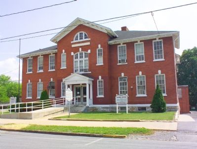
The present building was completed in 1917 under the leadership of Fred R. Ramer. He was the first principal in Berkeley County to have a school named after him. Ramer school served the black community until 1964. — — Map (db m1211) HM
On 11th Street at Veterans Memorial Boulevard (U.S. 60), on the left when traveling south on 11th Street.
Born and raised in Huntington, WV, Mary hopped a train and left town at age 13 to become a singer and dancer. She spent the 1920’s and 30’s performing in medicine and minstrel shows. During the 1940’s, Mary had diamonds removed from a bracelet and . . . — — Map (db m73736) HM
On Hal Greer Blvd at 9th Avenue on Hal Greer Blvd.
Historian, author, educator. Founder of the Assoc. for the Study of Negro Life & History, 1915. Began Journal of Negro History, 1916. In 1926 began Negro History Week, later Black History Month. A graduate and later principal, Douglass H.S., . . . — — Map (db m213391) HM
On 10th Avenue at Douglass Street / A D Lewis Avenue, on the right when traveling west on 10th Avenue.
Born on December 14, 1882, in
Montgomery, WV. Lavinia Norman
later attended Howard University
in Washington, DC. In 1908, with
eight other students, she founded
Alpha Kappa Alpha, the oldest
Greek-lettered organization for
African American . . . — — Map (db m125986) HM
Rev. Charles McGee chartered WV Normal Industrial School for Colored Orphans, 1899. Opened, Central City, 1900, moved to 190-acre farm near Huntington & Guyandotte R. Served African-American orphans and indigent. Bought, 1911, operated until 1956 . . . — — Map (db m73742) HM
Ephraim Bee and his wife Catherine's inn served
stages from the Northwest Turnpike. J.H. Diss Debar,
W.V. State Seal designer said seeing all the children
playing about, he had never dined in a Bee Hive before. Thereafter it was the Bee Hive Inn. . . . — — Map (db m31748) HM
Near Midland Trail (U.S. 60) 0.4 miles west of Short Street.
Construction of nearby tunnel, diverting waters of New R. through Gauley Mt. for hydroelectric power, resulted in state’s worst industrial disaster. Silica rock dust caused 109 admitted deaths in mostly black, migrant underground work force of . . . — — Map (db m34417) HM
On July 26, 1942 the first African American 4-H camp in the United States was opened here in Fayette County. A 1929 report showed that 44 of the state’s 55 counties had 4-H camps for white children, hut none for black children. Fleming Adolphus . . . — — Map (db m138104) HM
On Camp Carver Road (Local Route 11/3) 1.2 miles west of Clifftop Road (County Route 11), on the right when traveling north.
Camp named for Booker T. Washington (1856-1915) and George Washington Carver (1864-1943). Land deeded for sum of $5.00 by Charles and Kathryn Midelburg. Constructed 1939-1942 by local WPA labor with materials found on site including stone and native . . . — — Map (db m138103) HM
On 2nd Avenue (West Virginia Route 61) 0.1 miles east of College Street, on the right when traveling west.
Born in slavery in Monroe Co., Sept. 7, 1848, he worked as servant in the Confederate army. Served as teacher and ordained Baptist minister; estab. West Virginia Enterprise, Pioneer, & Mountain Eagle papers; later a lawyer. First . . . — — Map (db m34413) HM
On West Virginia Route 16 north of Virginia Street, on the right when traveling south.
An African American high school
formed in 1917, it educated black
Fayette County children until 1956.
Students were taught in community
buildings and churches, 1950-1954,
after the school was destroyed by
fire. The second DuBois High . . . — — Map (db m140445) HM
On High School Drive east of State Route 16/61, on the right when traveling east.
In 1906 a levy was passed in Fayette County to establish the county's first high schools, one for white children and one for black children. The original school for African American children was constructed at Turkey Knob, but was later replaced . . . — — Map (db m242569) HM
On Main Street (West Virginia Route 211) 0.2 miles west of Route 16, on the right when traveling east.
A cadre of excellent teachers sharing and imparting values produced students with interests and community endeavors, fundraising, and contributions to projects throughout the world.
Leadership – Principals
see photo
. . . — — Map (db m161345) HM
On Keeneys Creek Road (County Road 85/2) 3.3 miles west of San Mountain Road, on the right when traveling west.
Nuttallburg was built around this picturesque stream, called Short Creek. The creek played a major role in the life of residents. It provided water for residents, water for Nuttalburg industry, and it divided the community socially. . . . — — Map (db m242431) HM
On Keeneys Creek Road (Route 85/2) 3.3 miles west of San Mountain Road, on the left when traveling west.
You are standing in the heart of Nuttallburg's African-American community. The school for black children once stood on the foundation in front of you. The church for blacks stood on the foundation behind you. When coal companies designed their . . . — — Map (db m242430) HM
On Stanford Road (West Virginia Route 41) 0.2 miles north of County Road 41/27, on the right when traveling north.
In 1870 the Quinnimont Charter Oak and Iron Company built an iron furnace on Laurel Creek, which operated for three
years. The main line of the Chesapeake and Ohio Railway was completed through the gorge in the spring of 1873, and by
fall the . . . — — Map (db m165223) HM
Enslaved African, noted for bravery in defense of Fort Donnally during Shawnee attack May 29, 1778. He was granted his freedom by James Rodgers in 1801. Land granted to other defenders; his 1795 pension petition, supported locally, denied. . . . — — Map (db m21737) HM
On Main Street West (U.S. 60) 0.1 miles west of Salisbury Avenue, on the left when traveling west.
Born 1918 in White Sulphur Springs,
she attended high school at West
Virginia State College and received
a bachelor’s degree, 1937. In 1939,
she and two men were first blacks
to integrate WVU’s graduate school.
In 1953, she began a 33-year . . . — — Map (db m234297) HM
On Northwestern Turnpike (U.S. 50) just west of West Gravel Lane, on the right when traveling west.
Mt. Pisgah Benevolence Cemetery, since the 1800's, has been land for cemetery burial for black slaves, men who served in the Armed Forces, a governess who served for 25 years for the late Governor John Cornwell, two brothers who were barbers, . . . — — Map (db m150661) HM
On Olivet Drive, 0.5 miles east of Winchester Avenue (Old West Virginia Route 55), on the left when traveling south.
During the Civil War, Moorefield could be seen in front of you from this then-treeless hill. Beyond the town is the confluence of two watercourses that form the South Branch River. The Harness family cemetery was located at the northern end of . . . — — Map (db m155452) HM
Near Murphy Road, on the right when traveling south.
In it really began the Civil War. Here was lighted the torch of liberty for all America… For you this is the most hallowed shrine in this country. Henry McDonald, Storer College president
The foundations in front . . . — — Map (db m8318) HM
On Allstadt Hill Road, 0.2 miles north of Millville Road (County Route 27), on the left when traveling north.
The Allstadt House and Ordinary was the home of John H. Allstadt. On the evening of October 16, 1859, John Brown and his "army" of would-be slave liberators launched their attack on Harpers Ferry from Kennedy Farm just across the Potomac River in . . . — — Map (db m145216) HM
Near Shoreline Drive, 0.2 miles south of Pointfield Drive, on the left when traveling south.
Enjoy over 3,000 acres of rivers, trails, and battlefields in historic Harpers Ferry
Near the Visitor Center: Battlefields and Trails
Experience Harpers Ferry's tumultuous past. Pick up park trail maps and guides at the visitor . . . — — Map (db m143936) HM
On Murphy Road (Local Road 340/5) 0.3 miles south of Campground Road (Local Road 340/17), on the left when traveling south.
From Civil War to Civil Rights
In 1862 Union soldiers forced Edmund Chambers, this farm's first owner (1848-1869), from his home. The farm became a battlefield, where Confederate General A.P. Hill struck the winning blow of the Battle of . . . — — Map (db m143933) HM
On Shenandoah Street, on the right when traveling north.
(First Panel): Harpers Ferry National Historical Park is the story of... Industrial Development and the production of weapons at the Harpers Ferry armory. John Brown's Raid and his attempt to end slavery. The Civil War with Union and . . . — — Map (db m19008) HM
"I will pledge myself that there is not a spot in the United States which combines more or greater requisites...."
George Washington May 5, 1798 Harpers Ferry's history and geography have influenced each other for . . . — — Map (db m12065) HM
Near Murphy Road, on the right when traveling south.
Here on the scene of John Brown’s martyrdom we reconsecrate ourselves, our honor, our property to the final emancipation of the race which John Brown died to make free… Thank God for John Brown!... and all the hallowed dead who died for . . . — — Map (db m8316) HM
Near Murphy Road, on the right when traveling south.
In July 1896, members of the National League of Colored Women traveled here from Washington, D.C. and posed for their picture in front of John Brown’s Fort. The women came to pay homage to Brown and his raiders, establishing a pilgrimage . . . — — Map (db m8317) HM
Established 1869 Alexander Murphy 1840-1931 Mollie M. Murphy 1869-1945 Mary Murphy 1834-1908 William J. Murphy 1872-1931 Historical events on the Farm: Battle of Harpers Ferry September 13-15, 1862 General Philip Sheridan's Fortification August . . . — — Map (db m13275) HM
On South Seminary Street at East Avis Street, on the right when traveling south on South Seminary Street.
On December 16, 1836, Andrew Hunter and his wife Elizabeth sold this lot to the Trustees of the City of Charles Town and their successors in office forever, for the sum of fifty dollars. This lot was intended for and always be used as a potters . . . — — Map (db m157734) HM
On South West Street at West Congress Street, on the right when traveling south on South West Street. Reported permanently removed.
The first school for African-Americans in Charles Town started in December 1865 at the home of Achilles and Ellen Dixon, African-Americans who lived on Liberty Street. It was taught by Freewill Baptist Missionary Anne Dudley.
Between 1868 . . . — — Map (db m132452) HM
On Route 9 Bike Path, 0.8 miles north of Currie Road, on the right when traveling north.
This working farm was established in 1750 when Thomas Lord Fairfax granted 400 acres of his 5 million-acre Northern Neck Proprietary to Henry Lloyd. In 1774, the grant passed to Walter Baker, who is credited with building the original portion of . . . — — Map (db m207034) HM
On South Lawrence Street, 0.1 miles south of West Washington Street.
Erected by Most Worshipful Prince Hall Grand Lodge of West Virginia, Free and Accepted Masons, Incorporated In tribute to John Thomas Marker of Star Lodge #1, Charles Town First Most Worshipful Grand Master 1881 The Most Worshipful Grand Lodge of . . . — — Map (db m10645) HM
On George Street (West Virginia Route 115) north of Washington Street (West Virginia Route 51), on the right when traveling north.
Free African-American, born 1812 in Charles Town. Died 1885. Ability to read forced family to move to PA in 1822. Studied medicine and attended Harvard in 1850. Published Mystery, first black newspaper west of Allegh. 1843-47, & co-edited . . . — — Map (db m12639) HM
On South Lawrence Street, 0.1 miles south of West Washington Street, on the right when traveling south.
Erected in tribute to Martin Robinson Delany
Born free May 6, 1812 Lawrence and North Streets Charles Town, VA (W VA) Son of Samuel Delany (slave) and Patti Peace Delany (free) grandson of African prince Prince Hall Mason physician, scientist, . . . — — Map (db m168916) HM
On West Liberty Street at North Lawrence Street, on the right when traveling east on West Liberty Street.
Martin Robison Delany was born in Charlestown, Virginia (now Charles Town, West Virginia) on May 6, 1812. His mother, Patti Peace was a free black woman. She married an enslaved man from Berkeley County named Samuel Delany. They had five children . . . — — Map (db m132450) HM
On South Lawrence Street, 0.1 miles south of West Washington Street, on the right when traveling south.
Old Stone House. Star Lodge No. 1 and Queen of the Valley Lodge No. 1558, Independent Order of Odd Fellows, two African-American fraternal organizations, bought Old Stone House in 1885. Star Lodge sole owner since 1927. One of oldest extant . . . — — Map (db m24678) HM
On East Liberty Street west of North Samuel Street, on the right when traveling east.
On these grounds stood the first school for "colored" in Jefferson County. In 1867, the Freedmen's Bureau established this school at the home of Achilles Dixon, a blacksmith. Its first teachers were Annie Dudley and E.H. Oliver. It remained a school . . . — — Map (db m132446) HM
On East North Street east of North Mildred Street, on the right when traveling east.
This stone house represents one of the earliest stone structures built and owned by free Blacks in Charles Town. It was completed in 1830 by James H. Webb. Located on what was originally known as the "The Old Highway", travelers journeying from . . . — — Map (db m132443) HM
On George Street at Washington Street on George Street.
Jefferson County's Most Famous Trial
In the room immediately behind this wall, the abolitionist John Brown and five of his raiders were tried for treason against the state of Virginia, murder and inciting slaves to rebel. Brown had led 21 men . . . — — Map (db m21767) HM
On Shenandoah Street at High Street on Shenandoah Street.
The Small Arsenal building that stood here from 1806—1861 was one of two warehouses for the nearby United States Armory. A Harpers Ferry visitor in 1821 described both buildings as "arsenals for the deposit of arms manufactured, consisting of . . . — — Map (db m99508) HM
On Potomac Street north of Shenandoah Street, on the right when traveling east.
Hearing praise for "faithful slaves" during the dedication of the Heyward Shepherd memorial (to your left), Peal Tatten interrupted the ceremony. "I am the daughter of a [Union soldier]… who fought for the freedom of my people, who which John . . . — — Map (db m238207) HM
On Shenandoah Street at Potomac Street, on the right when traveling east on Shenandoah Street.
"The War That Ended Slavery"
Abolitionist Frederick Douglass, from his 1881 Storer College Commencement speech
"I want to free all the negroes in this [slave] state ... if the citizens interfere with me I must only burn . . . — — Map (db m143940) HM
Female students arriving here at the Cook Hall dormitory were greeted with a welcoming letter that advised them, “Here you will come as a refuge from the strangeness or perplexities of campus life. Here you will fight your battles of . . . — — Map (db m70830) HM
On Fillmore Street, on the right when traveling east. Reported permanently removed.
The struggle of today is not altogether for today -
it is for a vast future also.
Abraham Lincoln
You are standing near what was once an international border. During the Civil War, the peak to your left lay within the Union state . . . — — Map (db m70826) HM
On Fillmore Street just east of Storer College Place, on the right when traveling east.
You are standing near what was once an international border. During the Civil War, the peak to your left lay within the Union state of Maryland. Loudoun Heights to the right was claimed by the Confederate state of Virginia. Slavery divided the . . . — — Map (db m158441) HM
On Fillmore Street at Lancaster Street, on the right when traveling east on Fillmore Street.
Built in 1858, this house served as the home for the U.S. Armory superintendent's clerk. As an assistant to the superintendent, the clerk's responsibilities included drafting correspondence, filing reports, arranging schedules, and insuring the . . . — — Map (db m70779) HM
On Fillmore Street at Storer College Place, on the left when traveling east on Fillmore Street.
You are in the Camp Hill area of Harpers Ferry. Explore Camp Hill's history with exhibits in front of the Morrell, Brackett, and Lockwood houses and Mather Training Center. Side trails in Harper Cemetery and in front of Mather Training Center . . . — — Map (db m103584) HM
Harpers Ferry, including Anthony Hall (to your left), played host to large and small scenes in the epic human struggle for freedom and equality. In this building, the superintendent of the national armory contemplated how to strengthen the . . . — — Map (db m70797) HM
On Fillmore Street, on the right when traveling east.
Harpers Ferry, including Anthony Hall (behind you to the right), played host to large and small scenes in the epic human struggle for freedom and equality. In this building, the superintendent of the national armory contemplated how to . . . — — Map (db m70821) HM
On Mather Place, 0.1 miles south of Hartzog Drive when traveling south.
Harpers Ferry, including Anthony Hall (to your left), played host to large and small scenes in the epic human struggle for freedom and equality. In this building, Civil War generals planned their next attack. In the fields around you, Union and . . . — — Map (db m158638) HM
On Washington Street (Alternate U.S. 340) at Storer College Place on Washington Street.
Harpers Ferry. Named for Robert Harper, who settled here in 1747 and operated ferry. Site purchased for Federal arsenal and armory in 1796. John Hall first used interchangeable gun parts here. Travel route thru Blue Ridge gap, and river, . . . — — Map (db m82777) HM
A national controversy regarding the education of African American students played out in the building before you. Throughout its history, Storer College faced great difficulty attracting funding. Most white benefactors favored trade school . . . — — Map (db m70807) HM
Near Fillmore Street at Hartzog Drive, on the right when traveling east.
We want our children trained as intelligent human beings should be and we will fight for all time against any proposal to educate black boys and girls simply as servants and underlings, or simply for the use of other people. They have . . . — — Map (db m173635) HM
On Potomac Street at Shenandoah Street (Business U.S. 340), on the right when traveling east on Potomac Street.
On the night of October 16, 1859, Heyward Shepherd, an industrious and respected Colored freeman, was mortally wounded by John Brown's raiders in pursuance of his duties as an employee of the Baltimore and Ohio Railroad Company. He became the first . . . — — Map (db m126128) HM
Near Storer College Place, on the left when traveling south.
Here John Brown aimed at human slavery a blow that woke a guilty nation. With him fought seven slaves and sons of slaves. Over his crucified corpse marched 200,000 black soldiers and 4,000,000 freedmen singing “John Brown’s body lies . . . — — Map (db m158453) HM
On Shenandoah Street at Potomac Street on Shenandoah Street.
That this nation might have
a new birth of freedom,
That slavery should be removed
forever from American soil.
John Brown
and his 21 men gave their
lives.
To commemorate their
heroism, this tablet is
placed on this . . . — — Map (db m167876) HM WM
On South Potomac Street at Shenandoah Street (County Route 340/9), on the right when traveling east on South Potomac Street.
Here is a building with a curious past. Since its construction in 1848, it has been vandalized, dismantled, and moved four times - all because of its fame as John Brown's stronghold. The Fort's "Movements" 1848 Built as fire-engine house for . . . — — Map (db m4420) HM
Near Potomac Street just west of Shenadoah Street (Business U.S. 340), on the right when traveling west.
Commemorated here is the original location of the "John Brown Fort"--the Federal Armory's fire engine house where abolitionist John Brown and his raiders were captured by the U.S. Marines on October 18, 1859. If you look to the south, you will see . . . — — Map (db m10900) HM
Near Fillmore Street, 0.1 miles east of Columbia Street.
With its commanding view of Harpers Ferry and the Potomac River gap, this house has witnessed significant chapters in Harpers Ferry's history. It was built in 1847 as quarters for the U.S. Armory paymaster and later served as headquarters for Union . . . — — Map (db m238060) HM
On Fillmore Street east of Columbia Street, on the right when traveling east.
This house was built in 1858 as quarters for the U.S. Armory paymaster's clerk and his family. This clerk helped the paymaster manage the armory's complex budget and payroll, and assisted also with the collection of government quarters' rent and . . . — — Map (db m70750) HM
On Potomac Street, on the right when traveling west.
Thousands of enslaved people fled to the Union lines at Harpers Ferry during the Civil War. Some of them found shelter in the "contraband camp" located near here in the shadow of John Brown's Fort. Their freedom and safety were always in . . . — — Map (db m20491) HM
On Potomac Street, 0.1 miles north of Shenandoah Street, on the right when traveling north.
Along this path lie the remains of revolutions. Six acres of the U.S. Armory at Harpers Ferry have been reduced to rubble. Buildings that buzzed with activity and innovation now lie covered with dirt. Train tracks that pushed to the edge of a new . . . — — Map (db m20475) HM
Near Fillmore Street at Storer College Place, on the right when traveling east. Reported permanently removed.
Thousands of blacks seeking refuge from slavery and protection behind Union lines fled to Harpers Ferry during the Civil War.
Recognizing the importance of education for former slaves, the government’s Freedmen’s Bureau began a school here . . . — — Map (db m238230) HM
On McDowell Street just south of Fillmore Street, on the left when traveling north.
Female students arriving here at the Cook Hall dormitory were greeted with a welcoming letter that advised them, "Here you will come as refuge from the strangeness or perplexities of campus life. Here you will fight your battles of adjustment to . . . — — Map (db m158640) HM
On Fillmore Street, on the right when traveling east.
Here, on August 15-19, 1906, on the Storer College campus, the Niagara Movement held their first open and public meeting on American soil. Organized by W.E.B. Du Bois and others a year earlier in Erie Beach, Ontario, Canada, the Niagara Movement . . . — — Map (db m173629) HM
The battle we wage is not for ourselves alone but for all true Americans.
W.E.B. DuBois
In 1906, the Niagara Movement held its second annual meeting on the Storer College campus.
The Niagara Movement was the first national . . . — — Map (db m70829) HM
Near Fillmore Street at Storer College Place, on the right when traveling east.
We claim for ourselves every single right that belongs to a freeborn American, political, civil and social, and until we get these rights we will never cease to protest and assail the ears of America. The battle we wage is not for . . . — — Map (db m173631) HM
On Johnsontown Road just east of Hite Road, on the left when traveling west.
Founded by free African Americans, George W. & Betty Johnson, in 1848 on 12 acres, it was the first free black community in the state. Johnsons and other families built number of homes and a log, one-room graded school, which also served as a . . . — — Map (db m238231) HM
On South Fairfax Boulevard (West Virginia Route 115) at Mildred Street and 4th Avenue, in the median on South Fairfax Boulevard.
A distinguished clergyman, humanitarian, and civic leader in the community. Bishop Baltimore served as Senior Bishop & General President of the King’s Apostle Holiness Church of God, Inc. He was Pastor of The Baltimore Temple Church for 51 . . . — — Map (db m2030) HM
On North Church Street (County Road 480/1) just north of Old Queen Alley, on the right when traveling north.
This Old English/Episcopal Cemetery contains the graves of these Revolutionary War soldiers: Maj. Henry Bedinger, Anthony Kerney, Lt. Daniel Bedinger, James Kerney Sr., William Morgan Jr., William Lemen, Caleb Levick, Robert Tabb, and the . . . — — Map (db m157759) HM
On Kanawha Boulevard East, 0.1 miles east of Greenbrier Street (U.S. 60), on the right when traveling east.
Two companies of this regiment, consisting of 212 African American soldiers, were credited to WV. The men were recruited in Philadelphia in 1864, with several identified as born in WV, and fought at Chaffin's Farm, New Market Heights, Hatcher's Run, . . . — — Map (db m178804) HM
Near Kanawha Boulevard East (U.S. 60) 0.1 miles east of Greenbrier Street.
1856 - Born a lowly slave;
1915 - Died a great American.
Famous educator, author, lecturer and advocate of the doctrine of interracial cooperation.
Booker T. Washington was born near Hale's Ford, Franklin, County, VA. He spent his . . . — — Map (db m227472) HM
On Washington Street East (U.S. 60) just west of Sentz Street, on the right when traveling west.
Charleston Trails
"It is solved by walking."
- Latin proverb
"A taste for the beautiful is most cultivated out of doors."
- Henry David Thoreau
American writer & naturalist, 1817 - 1862 . . . — — Map (db m240797) HM
On Donnelly Street just north of Dickinson Street, on the right when traveling north.
Mattie V. Lee Home, Inc.
established in 1915
has been placed on the
National Register
of Historic Places
by the United States
Department of the Interior
— — Map (db m178797) HM
On Kanawha Boulevard East, 0.1 miles east of Elizabeth Street, on the right when traveling east.
In 1860 Virginia, nearly 491,000 men, women, and children of African descent were held in slavery under the law. Less than 4 percent lived in present-day West Virginia, the majority concentrated in seven counties. The geography and economy of . . . — — Map (db m178802) HM
On Shrewsbury Street north of Washington Street East (U.S. 60), on the right when traveling north.
Heart of the black community, area was the center for black business, education, religion, and social life but also had Greek, Italian, Lebanese and Syrian businesses. Many local black leaders had ties to the area, which declined due to 1960s . . . — — Map (db m76741) HM
On Shrewsbury Street north of Christopher Street, on the left when traveling north.
Heart of the black community, area was the center for black business, education, religion, and social life but also had Greek, Italian, Lebanese and Syrian businesses. Many local black leaders had ties to the area, which declined due to 1960s urban . . . — — Map (db m76760) HM
On Washington Street East (U.S. 60) just west of Sentz Street, on the right when traveling west.
The Block Historic District
During the early 1900's, the Great Migration began when millions of black people traveled from many rural southern states and headed for Chicago, Detroit, or Toledo, for a better way of life. As they . . . — — Map (db m178528) HM
On Washington Street (U.S. 60) at Pennsylvania Avenue (U.S. 119), on the right when traveling south on Washington Street.
According to legend, John Henry's profession as a steel-driver was measured in a race against a steam powered hammer, which he won, only to die in victory with his hammer in his hand as his heart gave out from stress. — — Map (db m228844) HM
On Kanawha Boulevard West just east of Florida Street, on the right when traveling east.
Born in Ohio in 1848, Davis served during the Civil War in the Union Light Guard of Ohio that was tasked with protecting President Lincoln. After the war, he moved to present-day Malden and later Charleston, where he served as an educator. His . . . — — Map (db m178787) HM
Near Washington Avenue just north of Chestnut Avenue, on the right when traveling south.
Jewels
Henry Arthur Callis •
Charles Henry Chapman •
Eugene Kinckle Jones •
George Biddle Kelley •
Nathaniel Allison Murray •
Robert Harold Ogle •
Vertner Woodson Tandy
Established By
Harry S. Blackiston •
James E. . . . — — Map (db m178749) HM
Near Fairlawn Avenue (West Virginia Route 25) 0.1 miles east of Barron Drive, on the right when traveling east.
President Hemphill, 2012-2016 served with unwavering passion and inspired a campus-wide focus on excellence, accountability and student-centeredness through rebranding, marketing and community engagement.
He led the effort to implement new . . . — — Map (db m178733) HM
Near Fairlawn Avenue (West Virginia Route 25) 0.1 miles east of Barron Drive, on the right when traveling east.
President Prillerman, 1909-1919, enjoyed tremendous success in advancing the institution. He developed an outstanding agricultural program, changed the name to West Virginia Collegiate Institute, offered the first college courses, provided extension . . . — — Map (db m178722) HM
On President Drive just south of Chestnut Avenue, on the right when traveling south.
Canty Hall
Built circa 1900
has been placed on the
National Register
of Historic Places
by the United States
Department of the Interior
— — Map (db m178737) HM
Near Barron Drive just south of Curtis Square, on the right when traveling south.
East Hall
Built circa 1893
has been placed on the
National Register
of Historic Places
by the United States
Department of the Interior
— — Map (db m178736) HM
Near Fairlawn Avenue (West Virginia Route 25) 0.1 miles east of Barron Drive, on the right when traveling east.
President McNeill's leadership, 1973-1981, was marked by vision, insight and courage. He developed the community college component, expanded the continuing education program, updated the campus master plan with emphasis on the renovations of older . . . — — Map (db m178729) HM
On Fairlawn Avenue (West Virginia Route 25) 0.1 miles east of Barron Drive.
President Carter's numerous achievements, 1987-, are astounding. His leadership resulted in three-year strategic plans; redesignation as an 1890 land grant college; the business, industry and education cluster; weekly television and radio programs; . . . — — Map (db m178732) HM
Near Fairlawn Avenue (West Virginia Route 25) 0.1 miles east of Barron Drive, on the right when traveling east.
President Jones, 1898-1909, was a visionary, speaker, writer, and man of action who brought the school a national reputation for excellence. He raised academic standards, added new and expanded existing departments, constructed four new buildings, . . . — — Map (db m178721) HM
Near Fairlawn Avenue (West Virginia Route 25) 0.1 miles east of Barron Drive, on the right when traveling east.
Principal Campbell, 1892-1894, successfully led West Virginia Colored Institute through its infancy. Admission standards were established, enrollment doubled, teacher and military training were made an important part of the curriculum, the first . . . — — Map (db m178717) HM
Near Fairlawn Avenue (West Virginia Route 25) 0.1 miles east of Barron Drive, on the right when traveling east.
Principal Hill's tenure, 1894-1898, was noted by the expansion of the campus with the construction of four new buildings to accommodate the school's growing enrollment. He initiated the concept of tailoring instruction to the individual needs of . . . — — Map (db m178718) HM
Near Fairlawn Avenue (West Virginia Route 25) 0.1 miles east of Barron Drive, on the right when traveling east.
President Davis' tenure, 1919-1953, brought sweeping and numerous changes, numerous honors, and unmatched distinction. He recruited an outstanding faculty, set high standards, added many activities, and had the name changed to West Virginia State . . . — — Map (db m178723) HM
179 entries matched your criteria. The first 100 are listed above. The final 79 ⊳