On Lemon Street north of 4th Street, on the right when traveling north.
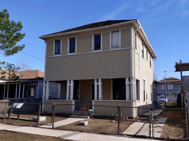
This house was purchased in 1915 by local restaurant proprietor Jukichi Harada in the names of his three American-born minor children. It was remodeled and expanded to two stories in 1916. The question of legal ownership of this house resulted in . . . — — Map (db m154720) HM
On Main Street, on the right when traveling south.
This building dates from 1927 when it was rebuilt after a fire in 1926. The upper floor served the Chinese population as a center for religious and social activities.
The Toy family operated a store two doors west called The Quong Wo Sing Co. . . . — — Map (db m18271) HM
This dry goods store was owned by
Kumataro & Rika Nakano in
Isleton's thriving Japantown.
The store was closed in 1942
when Executive Order 9066
mandated the incarceration of
110,000 Japanese on the West Coast
in isolated internment . . . — — Map (db m161964) HM
On Main Street near Levee Street, on the left when traveling south.
The largest, most complete, example of a rural agricultural Chinese-American community in the United States
Prior to 1915 this area consisted of four buildings and was part of the Locke Ranch known as "Lockeport". The name was later shortened to . . . — — Map (db m151428) HM
Near Main Street south of Locke Road, on the right when traveling south.
Locke
has been designated a
National Historic
Landmark
This site possesses national significance
in commemorating the history of the
United States of America
Locke Historic District is the largest and
most complete example of . . . — — Map (db m162018) HM
On Main Street, on the right when traveling south.
In memory of the industrious Chinese pioneers of California whose strength and sacrifice helped build the transcontinental railroad, construct the levees of the Sacramento San Joaquin Delta, and develop agriculture in the Central Valley. With . . . — — Map (db m18234) HM
On Main Street near Levee Street, on the left when traveling west.
Researched by Martha Esch, copyright 2016. '17 Citations verified by J'aime Rubio
For hundreds of years when the Sacramento Delta was a swamp, nearly the size of Rhode Island, Native Americans inhabited this area. Burial mounds of the . . . — — Map (db m151239) HM
On Locke Street at Main Street, on the right when traveling north on Locke Street.
Locke was founded in 1915 after fire destroyed most of the Chinese neighborhood in nearby Walnut Grove. The Chinese who lived in that community decided that it was time to establish a town of their own. After the fire, a group of Chinese merchants . . . — — Map (db m151238) HM
On 43rd Street at Folsom Boulevard on 43rd Street.
In memory of the persons
Laid to rest between
1849 and 1912 by the
County of Sacramento at
New Helvetia Cemetery
Dedicated by the
Sacramento County
Board of Supervisors
Sacramento County Cemetery Advisory Commission . . . — — Map (db m18967) HM
This marker has been dedicated in memory of more than six hundred persons of Japanese ancestry reinterred here in 1956 with several thousand others, whose remains were removed from New Helvetia Cemetery, the present site of Sutter Middle . . . — — Map (db m18938) HM
Near Palm Avenue at College Oak Drive, on the right when traveling west.
Walerga Assembly Center was established by the United States at the onset of World War II to assemble and temporarily detain, without charge or trial, 4,739 Sacramento residents solely because of their Japanese ancestry. Approximately 120,000 . . . — — Map (db m165486) HM
On 19th Street at K Street, on the right when traveling north on 19th Street.
Dr. Chung advocated for the voting rights of Chinese and American women through her
activism in the Woman's Auxiliary of the Chinese American League of Justice, the Chinese
Protective Association, and the Chinese Women's Reform Club.
Dr. . . . — — Map (db m171553) HM
On 19th Street at K Street, on the right when traveling north on 19th Street.
The first woman to receive a PhD. from Columbia University. Even after the passage of
the 19th amendment, Lee was unable to vote because of the Chinese Exclusion Act of
1882 until it was repealed years later. She became a well-known figure in the . . . — — Map (db m171510) HM
Near K Street at Interstate 5, on the right when traveling east.
The equality of education in Sacramento area schools had been the focus of a number of reformers. Educator activists in the 19th century are well represented by Sarah Jones, and in the 20th century by Mary Tsukamoto. Jones was an African American . . . — — Map (db m229891) HM
Near 3rd Street near Monterey Street, on the left when traveling south.
Jim Jack was known as China Jim, the Mustard King. In the 1880’s he gathered mustard seed from the grain fields in the San Juan Valley. Jim Jack, “the big-hearted Chinaman” had that rarest of gifts, the gift of giving. — — Map (db m62721) HM
While it appears to be part of the Quin Building, this structure is actually a separate addition built by Thomas Quin. Between 1930 and 1944, it was leased to several proprietors, and operated as an automobile service garage known as the Empire . . . — — Map (db m52685) HM
The original tenants of the two-story, Oriental-theme structure were the Gee Goon Tong, famous for their help in plotting the 1912 revolution which formed the Republic of China. The Benevolent Society was founded in 1920 as an outgrowth of the Tong, . . . — — Map (db m52949) HM
On Talbot Street at Anchorage Lane, on the right when traveling south on Talbot Street.
From around 1860 to the early 1890's, the Chinese had a fishing village at this site along the La Playa Trail. The village had ten shanties, drying racks and salting tanks. At the shore was a shipbuilding facility where Chinese junks were . . . — — Map (db m82320) HM
The south half of this building was the Hop Lee Chong Laundry, a Chinese laundry in continuous use from the building's construction in 1923 until 1964. The north half was the home of several Oriental businesses such as the "American Company", . . . — — Map (db m52651) HM
On 3rd Avenue at J Street, on the right when traveling south on 3rd Avenue.
This California Mission Revival-style building was designed by Louis Gill, nephew and protege of Irving Gill. The facade of the one-story chapel features a sloping red-tile roof over a central bell tower. The Chinese Mission, located in the building . . . — — Map (db m52947) HM
Near Convention Way at Marina Park Way, on the right when traveling west.
"Go forth, with spirit, the civic vision, and the courage to build the city of your dreams." —Alonzo E. Horton
A Vibrant New Town
The most striking evidence of the city’s downtown renaissance is its skyline. From the sculptural . . . — — Map (db m73906) HM
On Market Street at 4th Avenue, on the right when traveling east on Market Street.
The first floor of this building has a colorful tenant history. The Goodwill Bar operated from 1906 to 1945. In 1945, Mike McIntosh and Sam Dini purchased the business. They were responsible for the "McDini" corned beef sandwhich of local fame. In . . . — — Map (db m52682) HM
On 4th Avenue at Island Avenue, on the right when traveling south on 4th Avenue.
In 1930, this Spanish Colonial Revival style structure was built in the heart of Chinatown for Thomas A. Quin. The top portion had two apartments, and the bottom floor was a combination storefront and storage space. Seven years after its . . . — — Map (db m52687) HM
The Quong Building is not only an historical structure, it has also been the site of archeological digs. The building gets its name from Mow Yuen Quong, a business man who operated the structure from 1889 to 1928. The building has been listed in . . . — — Map (db m52948) HM
This pair of large stone lions made of granite from Mount Tai, which is considered the holiest mountain in China, has been placed in front of SDCHM and Extension. The stone lions are a gift to the city of San Diego from the Founding Executive . . . — — Map (db m203746)
On 3rd Avenue at J Street, on the right when traveling north on 3rd Avenue.
This pair of large stone lions made of granite from Mount Tai, which is considered the holiest mountain in China, has been placed in front of SDCHM and Extension. The stone lions are a gift to the city of San Diego from the Founding Executive . . . — — Map (db m203748)
On Pan American Rd E, on the right when traveling north.
1915 - 1955
In Balboa Park the year 1915, San Diego opened its Panama-California Exposition. Designed to call attention to San Diego and bolster the economy, the Exposition highlighted archaeological and anthropological displays as well as . . . — — Map (db m209206) HM
Although this building was not originally built by or used by Oriental tenants, its has found its home in the Asian community due to a succession of Japanese owners beginning in 1920. Under various proprietors, the structure was used primarily as a . . . — — Map (db m109356) HM
On Wentworth Place south of Jackson Street, on the right when traveling south.
Wentworth Place was
well known as a
street of commerce
where hawkers
would come to sell
preserved fish and
seafood, earning it
the moniker 'Salty
Fish Alley'. As
homage to this
legacy, students from
the Mandarin Institute have . . . — — Map (db m175279) HM
On Ross Alley near Jackson Street, on the right when traveling north.
Alleyways in Chinatown were created during the early settlement of Chinese in the late 1870’s. During that period, the rapidly-growing community was restricted by anti-Chinese sentiment to a six block area behind the back streets of the Barbary . . . — — Map (db m71997) HM
Near Pine Street at Quincy Street, on the left when traveling east.
We Salute These Americans of Chinese Ancestry who Gave Their Lives for America in World Wars I & II
Tom Kwong, Leo Sai, Bill Tom, Donald Ginn Chong, Lincoln Mark, Tung Ling Yee, Harry Wong, Daniel Lim, Clifford S. Low, Hon Y. Lee, John Wing . . . — — Map (db m71450) WM
On California Street just south of Grant Street, on the left when traveling west.
Founder of the Kuo Min Tang, Champion for Democracy, Father of the Chinese Republic and first President. Lover of mankind. Proponent of friendship and peace among the nations based on equality, justice and goodwill. — — Map (db m69511) HM
On Grant Avenue south of Sacramento Street, on the left when traveling north.
The staffs and management of the Far East Café welcome you into this enchanting restaurant that bring you back in time. Experience dining as it was once enjoyed by the people of ancient China. We serve fine Cantonese and Szechuan cuisine. Whether . . . — — Map (db m107302) HM
On Washington Street west of Stockton Street, on the left when traveling east.
The first Chinese American troop of
the Boy Scouts of America, Troop
Three of San Francisco, was founded
by eight boys on this Chinese
Methodist Church site in 1914. It is
one of the oldest active troops in the
United States.
Dedicated by . . . — — Map (db m186444) HM
On Waverly Place at Sacramento Street, on the left when traveling north on Waverly Place.
{The left side of the marker has the text in English:}
This church was organized on October 3, 1880. The congregation first met in rented quarters on Washington Street across from Portsmouth Square, and moved to the present location in . . . — — Map (db m52875) HM
On Hang Ah Alley / Pagoda Place, on the right when traveling south.
The Chinese Playground is one of the few
recreational facilities in Chinatown. In order
to make use of as much open space as possible, the Committee for Better Parks and Re
creation in Chinatown and the San Francisco
Department of Parks and . . . — — Map (db m175178) HM
On Pine Street at Kearny Street, on the right when traveling west on Pine Street.
On this site in 1851, Yee Ah Tye established the Sze Yup Company, one of the first
Chinese mutual aid associations in America. Sze Yup Company provided mutual support,
social services and economic aid. Constructed as a temple, the . . . — — Map (db m155185) HM
On Ross Alley at Washington Street, on the left when traveling north on Ross Alley.
Ross Alley is one of Chinatown's busiest alleyways, home to a mix of residences and businesses reflecting the everyday life and cultural traditions of the neighborhood. Tourists observe fortune cookies still folded by hand, local residents . . . — — Map (db m175261) HM
On Spofford Street at Washington Street, on the left when traveling south on Spofford Street.
In the past, Spofford Alley was one of the central avenues of Chinatown. The Chee Kung Tong [Chinese Free Mason], located at 36 Spofford Alley, was the meeting place of the revolutionaries led by Dr. Sun Yat Sen, who planned the overthrow of the . . . — — Map (db m175269) HM
Near Sacramento Street at Pagoda Place / Hang Ah Alley.
Standing at 5 feet 5 inches tall, Willie "Woo Woo” Wong grew up in San
Francisco to become one of the preeminent sport stars of the 1940's and
1950's. As a youngster, he perfected his basketbal skills during early morning
work-outs at Chinese . . . — — Map (db m175169) HM
On Market Street near Castro Street, on the right when traveling west.
Japanese-Americas human rights
activist and founder of the Critical
Path Project, one of the earliest
resources for information about
HIV research and treatment — — Map (db m120181) HM
Near The Embarcadero at Bryant Street, on the right.
This marker consists of six plaques arranged in a 2 X 3 pattern. The top left plaque is the title plaque and may contain some text. The top right plaque displayed an arrow which points in the direction of the named street. Other plaques contain . . . — — Map (db m92822) HM
On Sutter Street near Webster Street, on the left when traveling east.
Americanization was difficult for the Issei. Prejudice, language barriers and discrimination often stymied their efforts, yet they persisted, often venturing into Western society with great zeal. With the Nisei generation, however, the Japanese . . . — — Map (db m192570) HM
On Laguna Street south of Pine Street, on the right when traveling south.
Born in Germany on October 18, 1842, Captain Terschuren arrived in California during the Golden Age of Steam Boating (1849-1871).
In 1865, he took residency in San Francisco and was a well-known steamboat captain, river pilot and owner of . . . — — Map (db m162429) HM
On Sutter Street near Buchanan Street, on the left when traveling east.
Life in America was full of unknowns for an Issei (Japanese immigrant) departing Japan in the early l900s. She may have come to America as a laborer or accompanying her husband. More likely, she came as a picture bride through an arranged marriage . . . — — Map (db m86487) HM
On Laguna Street at Sutter Street, on the right when traveling south on Laguna Street.
Soto Mission of San Francisco
Sokoji 1934 - 1994
Soto Zen Buddhist Temple
Commemorating the 60th anniversary of the
founding of the Sokoji congregation, and the 10th
anniversary of the construction of this temple.
December 8, 1934 - . . . — — Map (db m162708) HM
On Post Street near Buchanan Street, on the left when traveling east.
Kitaichi Sakai arrived in San Francisco in the 1890s. He worked as a cook and sold fish door-to-door from a horse and buggy. After the 1906 Earthquake he opened a combined grocery, fish market and ship's chandlery on Geary Street. The store's name . . . — — Map (db m85558) HM
On The Embarcadero near Battery Street, on the left when traveling south.
As dreams and the spirit of adventure lured “fortune-hunters” from many parts of the world to California during the mid 1800s, so the news spread to the far reaches of China. To the Chinese, California came to symbolize an image of . . . — — Map (db m70853) HM
On Old Mason Street, on the left when traveling west.
This building was the site of the first class of the Military Intelligence Service Language School
November 1941 - April 1942
Eventually, six thousand Japanese-American soldier graduates served their country valiantly in the Pacific area . . . — — Map (db m29989) HM
On 10th Street north of Howard Street, on the left when traveling south.
The James Lick Baths/People's Laundry building served
as a public bath house for working-class San Franciscans
from 1890 - 1919. Financed by philanthropist James Lick, the
bath house had separate men's and women's facilities and a
distinctive . . . — — Map (db m155182) HM
On Columbia Square at Folsom Street, on the right when traveling south on Columbia Square.
Victoria Manalo Draves was the first Asian-American woman
to win an Olympic medal when she earned gold medals
in the 3-meter springboard and the 10-meter platform diving
competitions at the 1948 Olympics. Born in the South of
Market area to an . . . — — Map (db m120149) HM
On Castro Street near 18th Street, on the left when traveling north.
Passionate activist for queer Asians and Pacific Islanders and AIDS awareness who was instrumental is brining LGBT counseling programs to San Francisco public high schools. — — Map (db m99821) HM
On N. Center Street at E. Lindsay Street, on the left when traveling north on N. Center Street.
The Chinese community of Stockton dedicates this monument to the city of
Stockton to commemorate the bicentennial year of 1976, in memory of the
contributions which the Chinese have made to Stockton.
The ingenuity of the Chinese . . . — — Map (db m103083) HM
Here, within the confines of San Joaquin County Fairgrounds, enclosed by barbed wire and housed in temporary barracks, 4,217 San Joaquin County residents of Japanese ancestry, predominately American citizens, were interned from May 10 to October . . . — — Map (db m165485) HM
On West Clay Street at South Van Buren Street, on the right when traveling west on West Clay Street.
When new, this home was considered one of the finest in Stockton. It was bult by Wong K. Gew, a partner in the Lincoln Hotel and owner of the Tong King Company and other Stockton gambling establishments. There are 15 rooms; the interior is finished . . . — — Map (db m227503) HM
Near Center Street at Hesperian Lane, on the left when traveling west.
This property was once Cambria’s historical “Chinese Center,” the social focus for workers who harvested seaweed and abalone for shipment back to China, or worked in local quicksilver (mercury) mines in the mountains.
Here local . . . — — Map (db m68511) HM
This mosaic tile mural, placed in the heart of the historic Chinatown District of San Luis Obispo, commemorates our City’s Chinese pioneers. As immigrants they faced prejudice and exclusionary laws, but rose above such obstacles to make major . . . — — Map (db m52979) HM
Nurseryman Michael Lynch bought the property that is now the Stanford Redwood City campus in 1898. Lynch was best known for growing violets and sweet peas for sale as cut flowers and in seed packets. In 1901, he was hired by Jane Stanford to . . . — — Map (db m206591) HM
Near Tanforan Way east of El Camino Real, on the right when traveling east.
This garden memorializes a time when this site, then the Tanforan Park Racetrack, was transformed into a temporary assembly center for persons of Japanese ancestry. On February 19, 1942, in the absence of charges or due process of law, President . . . — — Map (db m165488) HM
Racetrack opened in 1899 and had racing seasons until it burned down in 1964. Many famous horses raced and won here.
In 1942, Tanforan became a temporary assembly center for over 4000 persons of Japanese ancestry who were to be interned for the . . . — — Map (db m165489) HM
Near Woodside Road, on the right when traveling south.
These stone walls are part of a network of trails and roads built by Chinese immigrants. In 1872 Simon L. Jones bought 1,500 acres of timberland in Woodside and developed them into farmlands, orchards and vineyards with the use of Chinese labor. . . . — — Map (db m63621) HM
On Gilroy Hot Springs road, 6 miles north of Roop Road, on the right when traveling north.
Under the guidance of the George Roop and William McDonald families
during the years 1865 of Francisco Cantua's discovery to the 1930's,
Gilroy Hot Springs was a popular health and family resort oriented
around a single hot mineral spring . . . — — Map (db m240828) HM
Evacuation and Interment of Morgan Hill Japanese-Americans, many later joined 442nd US Army Regimental Combat Team and fight in Europe, earning unprecedented decorations — — Map (db m213576) HM
On North 6th Street at Jackson Street, on the left when traveling south on North 6th Street.
They built a baseball diamond with the homeplate on the Jackson and Sixth Street corner and the outfield towards the railroad tracks. Rightfield was shorter and leftfield went on across Seventh Street. The centerfield was much lower than homeplate, . . . — — Map (db m52513) HM
On Jackson Street east of North 5th Street, on the right when traveling east.
“... you come upon the boiled eel, the quail’s eggs, the dried seaweed, and the squid like root called gobo, as well as the crinkly cabbage Japanese call napa and Korean pickled radishes packed in Hawaii and small cans of shrimp paste imported . . . — — Map (db m52508) HM
On Jackson Street east of North 4th Street, on the right when traveling east.
This is a picture of second generation Filipinos. Pacita Todtod who was also known as “Pacing” was famous for being a singer appearing at the beginning of the 1948 movie, “They Were Expendable,” starring John Wayne.
Curt . . . — — Map (db m52497) HM
On 5th Street south of Jackson Street, on the right when traveling south.
My grandmother kept her patients in the house for five days. My mother cooked the meals and grandmother would serve them. My mother was a very good cook. My dad taught her how; he’d learned to cook while working as a houseboy to put himself through . . . — — Map (db m52214) HM
On North 6th Street south of East Taylor Street, on the right when traveling south.
Ideal Laundry designed and built especially for laundry work and housed in a handsome, two-story fireproof brick building, erected as a cost of $30,000. This new enterprise was founded by I. Tsurukawa, one of the leading men in the local Japanese . . . — — Map (db m52549) HM
On North Fifth Streey at Jackson Street, on the right when traveling north on North Fifth Streey.
1887 Heinlenville Chinatown founded
1890 San Jose’s Japantown founded
1895 Wesley United Methodist Church established
1902 San Jose Buddhist Temple established
1910 Kuwabata Hospital built (Issei Memorial Building)
1916 Japanese Theater . . . — — Map (db m200160) HM
On Jackson Street at West 5th Street on Jackson Street.
I have been at this corner most of my life being born in the midwife house across the street. Nothing has changed in the neighborhood, except the people. I’ve seen Tokunaga go, Hashimoto’s Drug store across the street become a golf shop, Tom and . . . — — Map (db m52498) HM
On North 5th Street south of Jackson Street, on the right when traveling south.
The Nishiura Brothers built this Colonial Revival structure in 1910. Named after its first resident physician from Japan, Dr. Taisuka Kuwabara, the Kumamoto Kenjin-kai (a prefectural association) established the hospital to serve the Japanese . . . — — Map (db m52554) HM
On North 6th Street at Jackson Street, on the left when traveling north on North 6th Street.
San Jose Japantown was the center of many amusements. We had theater that performed Kabuki and modern shows, like “love stories.” When I was young, people gathered here with their horse and wagon – just tied their horse up to the . . . — — Map (db m65003) HM
On North 5th Street south of Jackson Street, on the right when traveling south.
From the late 1800s, Japantowns began to emerge in California’s port towns and agricultural areas where Japanese immigrants helped build the state’s economy through fishing, farming and other businesses. By the 1930s, as many as forty Japan towns . . . — — Map (db m52558) HM
On Jackson Street east of North 5th Street, on the right when traveling east.
When folks came back from the internment camps many of them were helped a lot by a local businessman, Torahiko Kawakami. He worked through the Buddhist Church hostel to resettle people and to get them back on their feet. He became known as . . . — — Map (db m52550) HM
On North 6th Street north of Jackson Street, on the left when traveling north.
Ken Ying Low was renowned for its homemade noodles, and visitors from Sacramento and San Francisco would always stop at the restaurant for “the best chow mein.” There were several generation of excellent cooks, and one remembered was Ng . . . — — Map (db m52548) HM
On North 5th Street at Jackson Street, on the left when traveling north on North 5th Street.
Because of the Alien Land Laws in California, Mr. Peckham held land in his name for those of Japanese, Chinese, Filipino and other Asian ancestries ... until the oldest native born child in the family turned 21. He would then transfer the land to . . . — — Map (db m65005) HM
On Jackson Street at North Fifth Street on Jackson Street.
[This marker is composed of four panels, each located at one corner of the intersection of Jackson and North Fifth Streets in San Jose.][Panel 1, south corner]
Pioneers
1890s to 1920s
During the 1890s, Nikkei (Japanese in . . . — — Map (db m52450) HM
On North 6th Street just north of Jackson Street, on the right when traveling south.
Card playing was a social outlet. When I was young, my grandfather brought me here when he stopped to see his friends. The windows were soaped to prevent people from peering in. I was only allowed to sit on a stool and watch the card games. The game . . . — — Map (db m52514) HM
On 5th Street, 0.1 miles north of Jackson Street, on the right when traveling north.
In 1902 a San Jose Buddhist Church was founded as a recognized branch of the San Francisco Buddhist Church. In 1906 property at 630 North 5th Street was purchased and services conducted by the first resident minister from Japan Reverend Honen . . . — — Map (db m26221) HM
On Jackson Street just north of North 6th Street, on the right when traveling east.
People also made a sumo wresting ring in the baseball grounds and had tournaments. Dr. James Dobashi was the strongest then. Nobody could even be compared with him.
Dr. Isamu Kawamura — — Map (db m52511) HM
On Jackson Street at North 5th Street, on the left when traveling east on Jackson Street.
Mr. Taketa built this hotel around 1915 to accommodate traveling businessmen and dignitaries to San Jose. There used to be a lot of people playing the game Go in the lobby.
Jimi Yamaichi, 2007 — — Map (db m52551) HM
On Jackson Street east of North 5th Street, on the right when traveling east.
There were several pool halls, but no gambling houses in Japantown. However a Japanese-operated print shop on Jackson Street which made cannery labels, printed lottery tickets for the Chinese. A gambling “runner” would come from . . . — — Map (db m52510) HM
On Jackson Street west of North 4th Street, on the left when traveling west.
We had everything in our store for the farmers. Dry goods. Work clothes. Japanese zori, tabi, pots and pans and dishes. We opened at seven in the morning and closed at ten at night everyday. Christmas day was one of the busiest days we had. New . . . — — Map (db m52496) HM
On North 5th Street just north of Jackson Street, on the right when traveling north.
The second Buddhist church building was situated where the Annex is now located. This building was established in 1908 as the “Independent Buddhist Church” when Reverend Hone Takahashi and certain church members seceded from the original . . . — — Map (db m65006) HM
On Jackson Street west of North 5th Street, on the right when traveling west.
The first Japanese American surgeon in San Jose was Dr. Lee Watanabe. His office was above Tom and Mary’s Snack Shop. He was pretty short, but when he was standing on his box doing surgery, he was a giant.
Sue Inouye — — Map (db m52494) HM
Wesley United Methodist Church was chartered August, 13, 1895 by the evangelical spirit and vision of pioneer Issei Christians and the struggles and hopes of immigrant families who had come to farm rich soil of the Santa Clara Valley.
With a . . . — — Map (db m52222) HM
On Jackson Street west of North 4th Street, on the right when traveling west.
Dad would teach us things, but we were not interested in the restaurant. We saw how hard he worked. He started working at ten in the morning and wouldn’t stop until two the next morning. Every day. Seven days a week.
Dr. James Chan, 2006 — — Map (db m52495) HM
On North 5th Street near East Taylor Street, on the left when traveling south.
Occupying the entire south side of Taylor Street between 5th and 6th was a truck transfer company owned by Mr. K. Yasunage. Farmers had to sell their produce in San Francisco and Oakland markets and needed someone to transport the produce. Most . . . — — Map (db m52493) HM
On Market Street at Paseo De San Antonio, on the right when traveling north on Market Street.
From 1872 to 1887, a large Chinese population occupied this block of Market Street. Despite considerable discrimination against them, the Chinese managed to survive within their insular community. By the late 1880's, as downtown businesses began . . . — — Map (db m26214) HM
On Paseo De San Antonio at South Market Street on Paseo De San Antonio.
In Memory of
The Burning of San Jose Chinatown
May 4, 1887
On this site on May 4, 1887 a mysterious fire, deliberately set, destroyed San Jose's Chinatown. This was the largest Chinatown South of San Francisco. A community of bachelors and . . . — — Map (db m26215) HM
Near Phelan Avenue east of Senter Road, on the left when traveling east.
The Vietnam War (1964-75) was America's longest war. For the Vietnamese, the war had begun in 1945 with the fight for independence from French colonial rule. In that struggle, the U.S. supported the French forces.
In 1975, South Vietnam's . . . — — Map (db m231601) HM
Near Phelan Avenue near Senter Road, on the left when traveling east.
Seventh graders from Quimby Oak Middle School's Lobo School of Innovation (LSI) honor Lee's Sandwiches, the popular Vietnamese-American fast-food franchise specializing in banh mi sandwiches and other Vietnamese cuisine items.
Chieu Le (Lê . . . — — Map (db m226845) HM
Near Phelan Avenue at Senter Road, on the left when traveling east.
The original Ng Shing Gung was constructed in 1888 in Heinlenville, the last of five San Jose Chinatowns. Heinlenville was named after John Heinlen, a German immigrant, who helped the Chinese after the Market Street Chinatown fire in 1887. Ng Shing . . . — — Map (db m226790) HM
Near Phelan Avenue at Senter Road, on the left when traveling east.
Farm, orchard, and cannery work in the Santa Clara Valley was seasonal. When a crop was ready to be harvested or processed in one of the Valley's many canneries, employers often supplemented their permanent workforce with workers hired on a . . . — — Map (db m231598) HM
Near Phelan Avenue near Senter Road. Reported permanently removed.
The original Ng Shing Gung, or Temple of Five Gods, was constructed in 1888 on Cleveland Avenue near Taylor Street in Heinlenville, and early San Jose Chinatown. Heinlenville consisted of a network of small streets within the block bordered by . . . — — Map (db m52164) HM
610 entries matched your criteria. Entries 201 through 300 are listed above. ⊲ Previous 100 — Next 100 ⊳