On Queen's Park Crescent East just north of Grosvenor Street, on the left when traveling north.
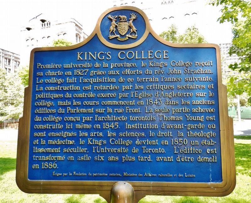
[English] The first university in this province, King's College was chartered in 1827 through the efforts of the Reverend John Strachan. This site was acquired by the College the following year. Sectarian and political criticism of . . . — — Map (db m207856) HM
Near Queen's Park Crescent East at Grosvenor Street, on the left when traveling north.
[English] In 1859, the city leased land here from King’s College, and in 1860 a park, named after Queen Victoria, was opened by the Prince of Wales, later Edward VII. Queen’s Park was long considered as a location for new parliament . . . — — Map (db m207768) HM
On Richmond Street East just west of Victoria Street, on the right when traveling west.
Once one of Toronto's grandest office buildings, this landmark served as the headquarters of the Confederation Life Association until 1955. Plans for the building arose from an international competition won by Knox, Elliot and Jarvis, architects. . . . — — Map (db m217687) HM
On Bay Street just north of Queen Street West, on the right when traveling north.
[English] Built between 1889 and 1899, this impressive Richardsonian Romanesque structure by local architect E. J. Lennox was the solution to the need of both the city of Toronto and York County for new quarters. Its superb downtown . . . — — Map (db m199998) HM
On Adelaide Street East just east of Spice Mill Lane, on the right when traveling east.
This building was Toronto’s city and county courthouse for nearly 50 years. It was Toronto’s third courthouse, designed by Cumberland & Ridout in the Classical Revival style, inspired by historic Greek architecture. Many high-profile trials were . . . — — Map (db m217427) HM
On Toronto Street just north of Court Street, on the right when traveling north.
This building was the headquarters of the Consumers’ Gas Company for 125 years. It was built in stages between 1852 and 1899 on what was one of Toronto’s principal financial streets. Architect Joseph Sheard designed the first building at 17 Toronto . . . — — Map (db m217415) HM
On Toronto Street just south of Adelaide Street East, on the right when traveling south.
This 11-storey building, designed by prominent Toronto architect E. J. Lennox, was the tallest building on the block at the time of construction. It was named after the Excelsior Life Insurance Company, whose offices were located within. It . . . — — Map (db m217511) HM
On Queen Street East just east of Bond Street, on the left when traveling east.
This "Cathedral of Methodism" was designed by Henry Langley in the High Victorian Gothic style. The cornerstone was laid by the Rev. Egerton Ryerson, D.D., in 1870 and the church was dedicated in 1872. It replaced an earlier structure at the . . . — — Map (db m207898) HM
On King Street East, 0.1 kilometers west of Jarvis Street, on the left when traveling west.
St. Lawrence Hall, one of the oldest public buildings in Toronto, was constructed following the Great Fire of 1849 that destroyed a large part of the city's core. Architect William Thomas designed the building in the Renaissance Revival style with . . . — — Map (db m217100) HM
On King Street East just east of Victoria Street, on the right when traveling east.
[English] The King Edward Hotel was built by George Gooderham's Toronto Hotel Company to meet the demand in the rising metropolis for a grand hotel. When it opened in 1903, the hotel, affectionately known as the “King Eddy”, was . . . — — Map (db m208383) HM
On Toronto Street at Old Post Office Lane, on the right when traveling south on Toronto Street.
[English] Built 1851-1853 for the Province of Canada, the seventh post office was designed by Toronto architects Frederic Cumberland and Thomas Ridout. The building, in the then popular Neo-classical style, resembles a Greek temple. The . . . — — Map (db m196176) HM
On King Street East just east of Church Street, on the right when traveling east.
[west side] The sculpture garden in this city park was constructed with generous contributions from the Louis L. Odette family and the Province of Ontario to promote the art of sculpture for the enjoyment of the people of Toronto. An art . . . — — Map (db m217547) HM
On Lombard Street at First Lane East, on the left when traveling west on Lombard Street.
This coat of arms was formerly located above the main entrance of Toronto’s eighth post office which was erected on part of this site in 1872-1873. The original building was designed by R. C. Windeyer, architect, and served as the main post office . . . — — Map (db m217655) HM
On King Street West at Emily Street, on the right when traveling east on King Street West.
St. Andrew’s was begun in 1874 to serve a Church of Scotland congregation organized in 1830. An outstanding example of Romanesque Revival architecture, this massive church was designed by William Storm (1826-92), a noted Toronto architect. The . . . — — Map (db m199996) HM
On Yonge Street just south of Colborne Street, on the right when traveling south.
Opened as the Hotel Mossop, this eight-story structure was one of Toronto’s first fireproof buildings. It was constructed in the aftermath of the 1904 Great Fire of Toronto, which destroyed over 100 buildings west of here. As a result, architect J. . . . — — Map (db m217516) HM
On Queen Street West just west of Yonge Street, on the left when traveling west.
[English] Department stores revolutionized shopping in the late nineteenth century by offering selection, low prices and money-back guarantees. In 1895, Robert Simpson commissioned architect Edmund Burke to design his new department . . . — — Map (db m208195) HM
On King Street West just west of Jordan Street, on the left when traveling west.
Upon completion, this 34-storey skyscraper was the tallest building in the British Empire and was praised as the “greatest addition to Toronto’s increasing, Manhattan-like skyline.” It was designed for The Canadian Bank of Commerce jointly by the . . . — — Map (db m217198) HM
On King Street West at Yonge Street, on the right when traveling east on King Street West.
Founded in Toronto in 1869, the Dominion Bank moved its head office to this site ten years later. In 1914, the bank's rise to national prominence led to the construction of this early 12-storey skyscraper. Beaux-Arts in style with Renaissance . . . — — Map (db m217451) HM
On King Street West just west of Bay Street, on the left when traveling west.
[English] Designed by Modernist architect Ludwig Mies van der Rohe in association with John B. Parkin Associates and Bregman and Hamann Architects, the Toronto-Dominion Centre is located in the heart of Toronto's financial district. . . . — — Map (db m199997) HM
Near Fort York Boulevard, 0.2 kilometers north of Lake Shore Boulevard West.
Originally a one-storey gunpowder magazine, this building's walls could not support the weight of the bombproof roof. The army replaced the roof and added a second floor in 1824 to store weapons and equipment. In 1838, the upper floor housed 5,000 . . . — — Map (db m237597) HM
Near Fort York Boulevard, 0.2 kilometers north of Lake Shore Boulevard West.
[English] Fort York constituted the primary defensive position in early York (Toronto). The present bildings, erected between 1813 and 1815 to replace those destroyed during the American occupations of York in 1813, are among the . . . — — Map (db m199282) HM
Near Fort York Boulevard, 0.2 kilometers north of Lake Shore Boulevard West.
From 1800 to 1813, 'Government House' stood in the centre of today's Fort York. It was the home and office of Upper Canada's lieutenant-governor, head of the colony's civil government. In stressful times, the office was combined with that of the . . . — — Map (db m237595) HM
Near Fort York Boulevard, 0.2 kilometers north of Lake Shore Boulevard West.
Like the No. 2 Blockhouse, this was one of the first buildings constructed during the refortification of Toronto in the second half of the War of 1812. The depression in the ground by the north wall is the approximate surface grade here in 1813; . . . — — Map (db m237598) HM
Near Fort York Boulevard, 0.2 kilometers north of Lake Shore Boulevard West.
In 1815 each of these buildings housed 100 people: soldiers, their wives and their children. In the 1820s, the army halved the number of occupants to improve living conditions. By the 1860s, only three men and their families lived in each room. . . . — — Map (db m237593) HM
Near Fort York Boulevard, 0.2 kilometers north of Lake Shore Boulevard West.
The Officers’ Blue Barracks housed junior officers: ensigns, lieutenants and some captains. Unlike the other structures in the fort, which are original to 1813-15, this building is largely a reconstruction. The army tore down the barracks' . . . — — Map (db m237596) HM
Near Fort York Boulevard, 0.2 kilometers north of Lake Shore Boulevard West.
One section of this building housed senior officers while another met most of the dining needs of all of the garrison officers. Sometimes officers lived here with their families, but most married officers lived more comfortably in town. Money vaults . . . — — Map (db m237594) HM
Near Fort York Boulevard, 0.2 kilometers north of Lake Shore Boulevard West.
The British Army constructed this building to house gunpowder and cartridges for artillery, muskets, rifles and other weapons. The magazine was bombproof in case of enemy attack. It also had features to prevent accidental explosions and to keep the . . . — — Map (db m237591) HM
Near Fort York Boulevard, 0.2 kilometers north of Lake Shore Boulevard West.
This reconstruction shows a typical 19th century British army well house. The hand-dug well was sunk in 1802, soon after Government House was built. The well is over seven metres deep, has an outside diameter of three metres, and is lined with . . . — — Map (db m237592) HM
On University Avenue just north of Queen Street West, on the right when traveling south.
[English] Campbell was born near Caithness, Scotland. He fought with the British forces during the American Revolution and was taken prisoner at Yorktown in 1781. Three years later he was practising law in Nova Scotia where, in 1799, he was . . . — — Map (db m208175) HM
On University Avenue just north of Armoury Street, on the right when traveling south.
Founded in 1906 as a private dining club for those with a university degree, the University Club of Toronto moved to this location on Toronto's ceremonial avenue in 1929. A design competition for a new building — restricted to architects who were . . . — — Map (db m217701) HM
On Queen Street East just west of Connaught Avenue, on the right when traveling west.
[English] This property was home to one family for two centuries. Sarah Ashbridge and her family moved here from Pennsylvania and began clearing land in 1794. Two years later they were granted 600 acres (243 hectares) between . . . — — Map (db m208200) HM
On Jarvis Street just north of King Street East, on the right when traveling north.
Distinguished by buff brick detailing, this row of three-storey buildings was constructed for Clarkson Jones, a barrister living north on Jarvis Street. Early tenants included two fruiterers and a saddler. Designated under the Ontario . . . — — Map (db m217197) HM
On Adelaide Street East just east of George Street, on the left when traveling east.
Designed by Toronto architect Henry Langley, this building was constructed as a boys school operated by the Brothers of the Christian Schools, a Catholic teaching order. The Brothers had purchased the former Bank of Upper Canada building to the . . . — — Map (db m217698) HM
On Adelaide Street East just east of George Street, on the right when traveling east.
Canada’s largest biscuit manufacturer, Christie, Brown & Co., built this factory complex over a 40-year period. At its peak, it employed nearly 400 workers. The original three-storey building was enlarged and altered in a variety of architectural . . . — — Map (db m217792) HM
On George Street just north of Adelaide Street East, on the right when traveling north.
Toronto’s First Post Office Toronto's First Post Office is the oldest purpose-built post office in Toronto still standing and in operation. The building is a rare example of a post office that served as a department of the British . . . — — Map (db m217799) HM
On King Street East just east of Church Street, on the left when traveling east.
York's first church was built here in 1803-07 with the aid of public subscriptions and a government grant. That frame building was enlarged in 1818-19 and replaced by a larger one in 1831. The first incumbent was the Rev. George Okill Stuart, who . . . — — Map (db m199499) HM
On Lombard Street just east of Church Street, on the right when traveling east.
The St. James Parking Garage, which opened in 1925, was one of the first multi-level parking garages in Toronto. In the mid-1920s, increased demand for parking led to the construction of several parking garages in Toronto’s downtown core. . . . — — Map (db m217857) HM
On Adelaide Street East just east of George Street, on the left when traveling east.
[English] Chartered in 1821, the Bank of Upper Canada, was until its demise in 1866, one of British North America's leading banks. It played a significant role in the development of Upper Canada — supplying currency, protecting . . . — — Map (db m199444) HM
On Jarvis Street just north of King Street East, on the right when traveling north.
This building was first constructed in 1833 for owner Daniel Brooke, a prominent merchant in the Town of York. It was substantially rebuilt between 1848-1849 prior to the Great Fire of April 1849 which started in a nearby stable. While much of the . . . — — Map (db m217196) HM
On Adelaide Street East just east of George Street, on the left when traveling east.
[English] Originally all post offices in Upper Canada were owned by the postmasters in charge, who were imperial appointments. This building was constructed for postmaster James Scott Howard during 1833-1835 and functioned as the . . . — — Map (db m208172) HM
Near University Avenue, 0.2 kilometers north of Queen Street West, on the right when traveling north.
[English] The fountains at 361 University Avenue were originally designed in 1964 by Landscape Architect Michael Hough to anchor the west end of the pedestrian mall that links University Avenue to Nathan Phillips Square. Symbolic of . . . — — Map (db m243783) HM
On University Avenue, 0.2 kilometers north of Queen Street West, on the right when traveling north.
ON THIS SITE STOOD the UNIVERSITY AVENUE ARMOURIES, the home of famous Toronto Regiments of the Canadian Army and the centre of Militia activities in Toronto from 1891 until it was demolished in 1963. A spacious riding school and gun park, erected . . . — — Map (db m217194) HM
On Water Street South at Main Street, on the left when traveling south on Water Street South.
Former Galt Post Office
This building, begun in 1884 and
finished in 1887, was erected to house
the post office, customs, and other
government services. It was designed
under Dominion chief architect
Thomas Fuller and built by . . . — — Map (db m231734) HM
On Young Street at Duke Street West, on the right when traveling north on Young Street.
Founded in 1857, St. Mary's is the oldest Roman Catholic parish in Kitchener (previously Berlin) The early congregation was largely German and Polish. Father George Laufhuber, S.J., was the first pastor.
Father Edward Glowacki, C.R. was appointed . . . — — Map (db m244291) HM
On Queen Street South at Mill Street, on the right when traveling south on Queen Street South.
Built around 1816, this house is a reminder of the migration of Pennsylvania German Mennonites to Waterloo County in the early 19th century. The movement was led by Joseph Schneider, the builder of the house, and his brother-in-law . . . — — Map (db m244284) HM
On Queen Street South, 0.1 kilometers north of Mill Street, on the right when traveling south.
This house, constructed in 1820 by Joseph Schneider
(1772-1843), is the oldest surviving dwelling in Kitchener.
Built of frame and originally covered with roughcast, it
has been little changed externally since 1850. Schneider,
a native of . . . — — Map (db m244278) HM
The log schoolhouse is Waterloo's first school and one of the oldest remaining log schoolhouses in the Province of Ontario. Built in 1820, the school was originally located near the corner of King and Central Street on lands donated by Abraham Erb. . . . — — Map (db m244177) HM
On King Street South at Union Boulevard on King Street South.
The head office of The Mutual Life Assurance Company of Canada (now the head office of Sun Life Financial's Canadian operations) was completed in 1912. Designed by Canadian architect Frank Darling, of the Toronto firm Darling and Pearson, . . . — — Map (db m244191) HM
On Main Street (County Road 124) at Overland Drive, on the right when traveling south on Main Street.
The process of officially designating the Stanley Park Gates & Arch under the Ontario Heritage Act was completed in September of 2017. The Gates and Arch are deemed to be of cultural heritage value, and interest. The designation recognizes their . . . — — Map (db m243399) HM
On Quebec Street just east of Norfolk Street, on the right when traveling east.
The south eastern unit built 1853 by John Catchpole, tinsmith. Probably the first stone structure on Norfolk Street. John Howard added the larger corner section in 1864. Imposing mid 19th century styled masonry. Designated as a Building of . . . — — Map (db m208699) HM
On Carden Street just west of Wyndham Street North, on the left when traveling west.
[English] Many Canadian cities erected well-designed municipal buildings during the mid-19th century railway boom. Guelph City Hall, one of the best of this group, symbolized the city’s confidence in its future. Designed by Toronto . . . — — Map (db m208693) HM
On Carden Street at Wyndham Street North, on the right when traveling east on Carden Street.
This fine example of classical architecture was begun in 1856 following the incorporation of Guelph as a town. It was designed by William Thomas, architect of St. Lawrence Hall, Toronto, and other important buildings throughout the province, and was . . . — — Map (db m196191) HM
On Carden Street just west of Wyndham Street North, on the left when traveling west.
This photo shows the original Town Hall and Market House designed by architect William Thomas. The building opened in 1857. The tower bell was rung daily at 7 a.m., 12 noon and 6 p.m., and during fires, funerals and special events. The central . . . — — Map (db m208695) HM
On Carden Street just east of Wilson Street, on the right when traveling east.
In 1899, based on the city's reputation for promoting advanced agriculture, Guelph's Market Square was selected to host the annual Provincial Winter Fair. The square was also used regularly for livestock competitions, cattle and horse auctions, . . . — — Map (db m208700) HM
On Quebec Street just east of Baker Street, on the left when traveling east.
Dedicated April 24, 1914 By M.W. Bro. The Hon. William David McPherson K.C. Grand Master Celebrated July 26, 2014 With M.W. Bro. Donald A. Campbell Grand Master — — Map (db m243397) HM
On Wyndham Street North at Macdonell Street, on the right when traveling south on Wyndham Street North.
In 1832 Canada Company Lot 108 was purchased by J.C.W. Daly, an agent of the Company. Later used as a merchant shop by Elizabeth Worsley, it was purchased from her estate in 1855 by the Emslie brothers, stone masons, builders, and owners of a . . . — — Map (db m208697) HM
On Yonge Street, 0.1 kilometers north of Mosley Street, on the right when traveling north.
Designed by the office of Dominion architect David Ewart, this building served as Aurora's post office from 1915 to 1968. It and its clock have long been focal points for community life. This building features a tower in the manner of an Italian . . . — — Map (db m196162) HM
258 entries matched your criteria. Entries 201 through 258 are listed above. ⊲ Previous 100