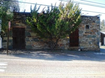
Erected circa 1860 by Theresa and Constantino Botto. Originally a Granary. Saloon for Central Eureka Miners Through the 1920’s. Second Wood Story Torn Down in the 1980’s. Placed by Janet Friedberg, Botto Descendent.
Amador County . . . — — Map (db m15827) HM
Was begun here in the early 1850’s as the Badger and later the Summit Mine. It consolidated with Hayward’s old Eureka Mine in 1924 as the Central Eureka Company, Amador Consolidated Mines. The main shaft reached a depth of 4,965’. It was the last of . . . — — Map (db m13084) HM
Eastern Shaft of the Wildman Mine located at the Post Office site. Used as an air chute and hoist shaft to dispose of waste rock later used to pave roads. The mine founded by William T. Wildman, circa 1851 — — Map (db m12601) HM
In Memory of General John A. Sutter, benefactor of the Great State of California, who mined here and gave Sutter Creek its name and under whose regime gold was discovered.
Also to those pioneer mothers, fathers and miners of the Mother Lode, . . . — — Map (db m13407) HM
Impulse turbines, also known as high pressure water wheels, were first developed in the foothill gold fields of Northern California to produce rotating mechanical power. Early water wheel designs were produced by Donnelly and Knight foundries of . . . — — Map (db m106398) HM
Knight Foundry was established in 1873 to supply heavy equipment and repair facilities to the gold mines and timber industry of the Mother Lode. Samuel N. Knight developed a high speed, cast iron water wheel which was a forerunner of the Pelton . . . — — Map (db m100590) HM
Knight Foundry Scarifier, Patent No. US 1665277 A, was developed in 1926 and patented in 1928 by Daniel (Dan) V. Ramazzotti, owner of Knight Foundry, as an improved mechanical ripper for removing uneven surfaces and ruts from roads. With the advent . . . — — Map (db m106423) HM
A man of tremendous ambition, Leland Stanford, Sr., was one of California’s most distinguished businessmen, politicians, philanthropists, and proponents of education. Lured to California by the Gold Rush in 1852, he became an owner of Sutter Creek’s . . . — — Map (db m12610) HM
First (1851) quartz mine & mill in Sutter Creek on Amador Road. Leland Stanford financier, politician and benefactor controlled this mine (1859-1872). Under Supt. R. C. Downs it proved a bonanza, aided Stanford to join the builders of the Central . . . — — Map (db m42409) HM
Founded in 1851 as Amador #2. Renamed the Union Mine and finally the Lincoln Mine by new owner Leland Stanford. Worked until 1924, producing $2 million. Consolidated with Wildman- Mahoney Mines. Foundations and dump remain. — — Map (db m44607) HM
Founded by Jerry Mahoney from Killarney, Ireland in 1851. Claim purchased from Alvinza Hayward. Merged with the Wildman Mine and reached a depth of 1200 feet. Produced $5 million in gold. Later part of Lincoln Consolidated Co. — — Map (db m12606) HM
Sutter Creek, California
Left Panel:
Like many communities in the Sierra Foothills, Sutter Creek grew out of the great gold rush of 1849. Thousands of men of every nationality arrived seeking fortunes through toil, sweat, and luck. . . . — — Map (db m106380) HM
The Old Eureka Mine was first opened in 1852 and comprised the Amador, Maxwell, Alpha, and Railroad claims. At various times it was known as the Hayward, Eureka, Hetty Green, Badger and Wolverine, and Amador Consolidated mines.
One ore shoot . . . — — Map (db m240055) HM
Founded in early 1850’s by Alvinza Hayward, owner of the Badger and Wolverine Mines. Earned $65,000 a month, reaching a depth of 2,250 in late 1800’s. Shaft sunk to 3,500 feet in 1916. In 1924 was purchased by Central Eureka Company. Closed in 1942 . . . — — Map (db m44606) HM
Associate of Leland Stanford, Pioneer, Miner, Legislator, Businessman. Sailed around Cape Horn on clipper ship Tahamaroo in 1849. Established the first deep quartz mine, The Union, with E.B. McIntyre, S. Hanford & N. Drew in 1851. Became . . . — — Map (db m29829) HM
Founded by William T. Wildman in 1851. Merged with Mahoney Mine and reached a depth of 1500 feet. Combined mines operated a 70 stamp mill and produced a total of $5 million in old by 1924. Powder house used to store explosives. Became part of . . . — — Map (db m12598) HM
In Memory of Forty-Niner
William Barker Hubbell
1816 – 1894
Who built his building for a
General Store circa 1867
Served as Justice of the Peace
1888 – 1892 — — Map (db m29858) HM
Here in Volcano in 1860, miner and amateur astronomer George Madeira built California's first astronomical observatory of record and operated it for two years. Using a three inch refractory telescope he studied sun and moon, stars and planets, and . . . — — Map (db m100583) HM
Located 3.49 miles southwest of this location on Sutter Creek Volcano Road several hundred feet above the river. This quarry produced high quality marble used in the construction of Stanford University as well as many of San Francisco’s civic . . . — — Map (db m27809) HM
This plaque is in memory of the pioneers of California who assembled in Volcano where Moose Milk was originated.
Dedicated this 13th day of January, 1951 by E Clampus Vitus.
[A rededication marker, just below the main one, . . . — — Map (db m9055) HM
Built in 1856, the Bavarian Brewery is one of two historic breweries in Volcano, named for brewer Peter Seible. A notable example of early masonry, the precisely cut stones in the front facade are still plumb today. The deep cellar, used for the . . . — — Map (db m200302) HM
A place for fun, frolic, dancing and good food for early gold miners and lumber mill workers.
Room on the right served as the
Justice Court, scene of
the first hanging trial held by
Judge Jonas, original owner
Renovated in 1987 by . . . — — Map (db m15832) HM
Discovered in 1848 by Colonel Stevenson’s men who mined Soldiers’ Gulch in ’49. First covered wagon party sluiced rich gravel beds. By ’53, men swarmed flats and gulches naming them picturesquely. Hydraulic operations, begun in ’55, brought . . . — — Map (db m11365) HM
John Bidwell was born on the east coast to a poor farming family in 1819. In spite of these modest roots, he would eventually become a key figure in California history, one famous for being a true pioneer, a statesman, politician, prohibitionist, . . . — — Map (db m29637) HM
Born in Bucks County Pennsylvania, Neal a blacksmith by trade came to California with John Fremont’s second expedition in 1844. After working for John Sutter briefly at New Helvetia, obtained a land grant and established Rancho Esquon. After . . . — — Map (db m61826) HM
In June, 1864, the Chico and Humboldt Wagon Road Company began to construct a road to connect Chico with the Idaho mines. A toll station for the Chico and Humboldt Wagon Road stood nearby to the left.
A Georgian, Nick Spires, is said to have . . . — — Map (db m61766) HM
Dedicated in the spring of 1863, this building served as a temple of worship for 10,000 Chinese then living here. Funds for its erection and furnishings were provided by the Emperor and Empress of China and local Chinese labor built the structure. . . . — — Map (db m100599) HM
Edison Ore Mining & Miocene Mining Co. Oct. 1879 to May 1881 by Major Frank McLaughlin searched for platinum to use in Edison’s electric light globe. Used a process to remove gold from black sands found in mine tailings.
Miocene Mining Co. . . . — — Map (db m61556) HM
This tablet commemorates
the establishment
of the
First Banking Institution
in
Ophir
now
Oroville
which was located on this site
and occupied by
McWilliams & Tymeson -
G.A. Emery - Geo. Faulkner & Co. 1855-1865 . . . — — Map (db m25694) HM
In 1911, Lawrence Gardella, an Oroville native and successful dredge operator, built this commercial structure to replace the historic Gem Saloon as part of Oroville’s prohibition movement, which was one of the finest in its day. The first floor . . . — — Map (db m219769) HM
In 1888, James C. Gray purchased Brock and Tabor Hardware at 1950 Montgomery Street. That purchase included the lot you are standing on now. In 1898 Gray built a 50‘ by 100‘ building to house Ophir Hardware. The original building was a single story, . . . — — Map (db m176229) HM
Construction of the Oroville Inn commenced in 1929 and was halted due to the Great Depression. Two hundred local residents, in an impressive display of community, came together to complete the Inn which opened June 1, 1930. They became shareholders . . . — — Map (db m176288) HM
In deep appreciation of those who had the foresight to plan, design, and construct the Oroville Dam Project and to those who have been operating and maintaining it for the State Water Project and the people of California.
Since its . . . — — Map (db m101447) HM
"Site of 1st Sawmill
Erected by Argonaut Parlor No. 8 Native Sons and Gold of Ophir Parlor No. 190 Native Daughters, commemorating the Bicentennial Year 1776 – 1976” — — Map (db m61558) HM
Built 1855
Restored 1976 by
Aerie No. 196 – Fraternal
Order of Eagles, Oroville
(Seal of the American Revolution Bicentennial 1776-1976) — — Map (db m65907) HM
McWilliams & Tymeson
1855
Wells Fargo & Company
Express Agents
First Brick Bldg in Oroville
Fraternal Order of Eagles No. 196
(Seal of the American Revolution Bicentennial 1776-1976) — — Map (db m65906) HM
“Site of first flour mill in Ophir City now Oroville, built in 1858. Erected and dedicated by Argonaut Parlor No. 8 Native Sons and Gold of Ophir Parlor No. 190 Native Daughters as part of the Bicentennial Year Celebration 1776 – . . . — — Map (db m65842) HM
The rail yard housed the depot, a water tank, a stockyard, as well as a siding and spur. A motorcar house was located further up the track. The depot was retired on January 19, 1960.
The coming of the railroad was the major event that sparked . . . — — Map (db m29674) HM
Editor's Note: All the "E's" on this marker are backwards
The historic inn, first built in 1857 by Pat Kelley sold to John Stokes in 1866.
Destroyed by fire in 1868. Rebuilt in 1868, is the only remaining one of five hotels which . . . — — Map (db m61765) HM
This peaceful community, gateway to the remote regions of the High Lakes of Butte and Plumas Counties, owes its origin and subsequent development to the entrance of the Diamond Match Company to California. With the purchase of about 40,000 acres of . . . — — Map (db m61764) HM
Is the site of the longest running continuously operated foundry west of the Mississippi River. All quartz machinery needed for the numerous mines surrounding the Altaville, Angels Camp area was cast here. It was previously known as Altaville . . . — — Map (db m13005) HM
This structure was erected in 1852 by B. R. Prince and G. Garibardi for a general merchandise business. Improved in 1857 with living quarters on the second floor, it is still used for living and warehouse purposes. — — Map (db m11047) HM
Andrew Brosemer followed his
childhood sweetheart, Elizabeth Huberty,
from Belgium. She came with her family
from Luxembourg to Calaveras County
in 1886 to join her uncle who had
homesteaded a ranch in the 1850’s.
Andrew properly . . . — — Map (db m19326) HM
Founded in 1849 by George Angel, who established a mining camp and trading store 200 feet below this marker. A rich gravel mining area and one of the richest quartz mining sections of the Mother Lode. Production records of over $100 million for . . . — — Map (db m14460) HM
C.C. Lake erected here a canvas hotel in 1851. It was replaced by a one-story wooden structure, and then by one of stone in 1855, with second story being added in 1857. Here, Samuel Clemens first heard the yarn, which was later to bring him fame as . . . — — Map (db m17664) HM
He was born Sept. 25, 1882 on the old Stevenot Homestead one-half mile west of this marker. Son of Emile K. and Sarah E. Stevenot and the grandson of Gabriel K. Stevenot, Calaveras County pioneer who pitched tent there in April, 1850.
Student, . . . — — Map (db m6847) HM
Fashioned as either small ornaments or large enough to be heard for miles, bells have long been a part of human history and culture. First appearing around 2000 B.C. as simple percussion instruments, they continue to celebrate special events to this . . . — — Map (db m101587) HM
The use of wheels to convert flowing or falling water into power began in ancient Greece around the third to the first century B.C. In 1878 Lester Allan Pelton, a carpenter and blacksmith from Nevada City, invented a new design for an impulse water . . . — — Map (db m101590) HM
Gold discovered in creek just below town by James H. Carson in 1848, whose name was given to creek, hill and town. In November, 1854, at Morgan Mine, was found the largest gold nugget in California, weighing 195 pounds troy, worth at that time . . . — — Map (db m6848) HM
Built in the early 1850’s, year not documented, by Frank Egan, as the Central Park Hotel. Then, it included a brothel upstairs. The hotel was sold to Mrs. Mitrovich and renamed The Waverly Hotel. Blagoje “Billy” Ratkovich bought the . . . — — Map (db m40811) HM
In Tribute
To the pioneer craftsman whose skills, ingenuity and determination established permanent communities in the wake of the gold rush, and whose progeny have continued to contribute to the region’s character and spirit, recognition is . . . — — Map (db m58925) HM
A gold furnace was commonly used to separate mercury from the gold. In gold placer mining, in which small specks and veins of gold were often found in quartz, mercury was used to separate the gold from the quartz. This bonding of the mercury . . . — — Map (db m57172) HM
In 1895 Harry Hogarth, James Candy and Naylor Williams filed a claim for the Relief Quartz Mine on a hillside above Six Mile Creek near Angels Camp. In 1920, after working the claim by hand for many years, the Hogarths; Harry Sr, Harry Jr, and . . . — — Map (db m56553) HM
This steam traction engine was built by Owens, Lane, Dyer & Co. of Hamilton Ohio most likely in the 1870s. Its particular gear drive mechanism, along with the incline cylinder distinguish it as an O.L.D. & Co. machine. According to the story, this . . . — — Map (db m101594) HM
This mine site was located in 1855 by Peter Cameron, A.M. Wood, Will Powell and C.G. Lake. Lightner Mining Company organized and operated from 1896-1915. A 40 stamp mill crushed 500,000 tons of ore from vein which widened to 120’. Ore stopped at . . . — — Map (db m10633) HM
This Best 110 hp steam traction engine, built 1903-1906, was originally used by Pacific Borax Co. to pull ore wagons. The next owner was the Dixie Mill, near Sheep Ranch, where it was used to haul logs down the steep hillsides to the loading deck. . . . — — Map (db m101613) HM
This core section was created in 1934 while boring an air/service shaft for the Idaho-Maryland Mine in Grass Valley, California. The overseer of this demanding project was mining engineer J.B. Newsome. Reputed to be the largest drill core of its . . . — — Map (db m101617) HM
SIGNAL CANNON Small cannons, like our iron example, were usually intended to fire signals rather than function as weapons. Also known as salute cannons, many were used onboard ships and were often mounted on a swivel, as this example may have . . . — — Map (db m101619) HM
The Hogarth Family has had a long involvement with the mining industry in Angels Camp. Patriarch Henry ("Harry") Hogarth, Sr. was born in Scotland in 1831. He immigrated to the United States at an early age and soon settled on a career as a . . . — — Map (db m56558) HM
Common in California after 1853, the stamp mill consisted from one to five heavy pillar-like stamps whose bottom, (or shoes), were cylindrical hammers made of iron, each weighing as much as one thousand pounds. Power to operate the stamps was . . . — — Map (db m56556) HM
Hydraulic Mining was the largest and most destructive form of mining. Water, brought through flumes and ditches from high up in the mountains, was redirected into an ever-narrowing channel and out through a giant iron nozzle, called a . . . — — Map (db m56649) HM
Utica Mine, the most important mine in the Angels District, set national records in the 1890's producing more than 4 million dollars in gold in 30 months. The Utica was also the site of Angels Camp's worst mine disaster when 17 men were buried when . . . — — Map (db m25646) HM
Water wheels were commonplace to the gold mining regions, providing power for mining and milling operations. Powered by water the wheel was attached to a series of belts and gears which turned the machinery to crush the ores. This water wheel . . . — — Map (db m56559) HM
When mine shafts became to deep, a whim was needed to recover the ore in buckets. Joshua Hendy developed the Davis Horse-Power Hoisting Whim, exhibited here. The whim was a large drum made from wood in the early years, and later metal, with a . . . — — Map (db m56616) HM
Calaveritas, settled in 1849 by Mexicans, was a flourishing mining town complete with stores, saloons, gambling houses, and fandango halls. Joaquin Murieta is reported to have frequently visited its Fandango Halls and gambling houses. Destroyed by . . . — — Map (db m12992) HM
He conducted a butcher shop, a distillery and various other enterprises in these buildings, for a total of 50 years. Descendants of Luigi and Charlotte Costa have preserved this handsome example of the heritage of Calaveritas. — — Map (db m12994) HM
Settled in 1849 by Mexicans who worked placers in Oregon Gulch. Rich copper deposits discovered in 1859. The largest living cork oak tree in California was planted here in 1858. Ruins of Adams Express Building still standing. — — Map (db m10629) HM
Present site of one of the last family-founded and-still-operated-by-that-family phone companies in America. Founded by Jim Tower, who strung his first telephone wires in 1895 tacked along posts of barb wire fences, earning himself the colorful . . . — — Map (db m57982) HM
Copper here discovered by W. K. Reed and Thomas McCarty in 1860. Mines utilized during the Civil War and the First and Second World Wars. During Civil War period was the principal copper producing section of the United States. — — Map (db m13002) HM
With the discovery of copper ore in 1860 by Thomas McCarty and William K. Reed, the town of Copperopolis sprang into existence and soon became the largest producer of copper in the western United States. The population of Copperopolis grew to exceed . . . — — Map (db m13004) HM
Copperopolis Armory, built by public subscription in 1866 for 8,000 dollars, was used by the Union Guard for enlisting and training troops. In 1866 it was sold to the Copperopolis Armory Hall Association for 800 dollars in gold and was used for . . . — — Map (db m13003) HM
Although Copperopolis is known for copper mining, gold was discovered here in 1858, copper in 1860. The gold belt was a mile west of the copper belt.
The Madame Felix Mining District produced 200,000 ounces of gold between 1864 and 1974. . . . — — Map (db m58927) HM
In 1852 a chain cable bridge replaced the ferries that once crossed here, to be supplanted in its turn by a covered truss structure in 1862. Some writers claimed this was the locale of Bret Harte's Poker Flat. In late “49” there was a large camp . . . — — Map (db m13013) HM
In the 1860’s Copperopolis had a population of 10,000 and was the principal mine in the west. The mine closed in 1945.
This building has housed a saloon since it was built in 1862. Twice it survived raging fires which destroyed the town.
The bar . . . — — Map (db m19770) HM
Pioneer Settler & Rancher of Calaveras Co.
Discoverer of copper ore at Copperopolis, Calif. In 1860. Developed mine & was principal share owner, Town was named for the Copper ore. It was a boom town during the Civil War. Copper was used in . . . — — Map (db m19766) HM
Built in 1860 by John and Rebecca Gardner, this was a stage coach stop on the Big Trees Carson Valley Road. A toll road from 1862 – 1910. The hotel served as a depot for stockmen and as a summer resort.
Noted for its ice cold . . . — — Map (db m57983) HM
A portion of this building served as the Calaveras County Courthouse from 1852 to 1866, when the county seat was removed to San Andreas. George W. Leger then acquired the court building and made it a part of his adjoining hotel, which has been . . . — — Map (db m11537) HM
Richest placer mining section, extending five miles, in Calaveras County. Received name from Chileans who worked gulch in 1848 and 1849, and scene of the so-called Chilean War. Largest known quartz crystals recovered from mine on south side of gulch. — — Map (db m11515) HM
Mokelumne is an Indian word, first applied to the nearby river. Earliest settlement was at Happy Valley by French trappers. Gold was discovered by discharged members of Stevenson's Regiment in 1848. Center of the richest placer mining section of . . . — — Map (db m12996) HM
This original stone building was built in 1889 by Peter Malaspina. The family run business housed a general store and, in 1917 a standard oil station was added. First run by John Henry and Mary Malaspina-Batten and later, daughter Ina Batten-Davies, . . . — — Map (db m218942) HM
Founder of Murphys, 1848.
John and brother Daniel set up trading post; hired Miwok Indians to mine gravel – paid them in merchandise
Murphys was first known as Murphys Diggings; then Murphys Camp – later Murphys
John Murphy . . . — — Map (db m34335) HM
After a fire in 1859, pioneer Doctor Jones rebuilt this structure to withstand future disasters. It served as his office, and is constructed of limestone, brick, 30 inch windowless walls and iron shuttered doors. In 1867, it was sold to John Hauselt . . . — — Map (db m16049) HM
Member of Fremont’s Battalion during Mexican War. Established Indian trading posts throughout Central San Joaquin Valley. Leader of the first expedition of the Mariposa Battalion into Yosemite Valley, 1851
Dr. Lewis Leach described Savage as . . . — — Map (db m34057) HM
The brothers John Murphy (1824-1892) and Daniel Murphy (1826-1882) reportedly pitched their trading tent near this site late in 1848. — — Map (db m51558) HM
One of the principal mining communities in Calaveras County, named for the discoverer of gold on the flat in 1849. The objective of many immigrants coming over the Sierras by Ebbetts Pass, Murphys Flat and surrounding mines produced 20,000,000 . . . — — Map (db m149203) HM
James L. Sperry and John Perry opened the Sperry and Perry Hotel August 20, 1856. In 1881 Henry Atwood and then Harvey Blood owned it. In 1882, the Mitchler family renamed it the Mitchler Hotel. In 1945, the McKimins’ changed its name to Murphys . . . — — Map (db m2612) HM
Rebuilt in 1859 as a stone, fire-proof, grocery and provisions store by Vassallo & Co. In 1861 was the homestead of J.C. Green & Wife. By 1863 owned & operated as a bakery by B.M. Orengo & Ruiseco. It is said that the baker Ruiseco was shot to death . . . — — Map (db m51568) HM
This hostelry originally built in 1855 by J. L. Sperry of Sperry Flour fame and his partner John Perry. Among early guests whose names appear on old register are Mark Twain, Horatio Alger, Thomas H. Lipton, Henry Ward Beecher, the Rothchilds General . . . — — Map (db m143521) HM
A thriving mining camp on rich Pennsylvania Gulch in the 1850’s and 1860’s. Named for Alfred Brown, former owner of Table Mountain Ranch. Laws of Brownsville Mining District provided that each miner could own one wet and one dry claim, not to exceed . . . — — Map (db m11501) HM
Built in 1858 by Pierre Bonet with fire proof steel shutters and stone walls. Owned and operated by Victorene Compere to provision the miners. Restored and preserved as a private residence in 1939.
Historic American Building Survey No. 1108 . . . — — Map (db m32872) HM
One of the pioneer structures in Murphys, built after the great fire of 1859 by Freeman Dunbar and Company and called Union Saloon and Bowling Alley. It was operated in the 1870’s by W.C. Crispin, and in the 1880’s by Charles E. Fisk. Later it was a . . . — — Map (db m32814) HM
Built soon after 1856 by John Thompson operator of Lime Kiln on Posky Hill and stone mason, who built adjoining Traver Building, and many other stone buildings.
Occupied, circa 58, by Meyer & Friedlander, General Merchandise. Later Fred Sackett . . . — — Map (db m13027) HM
This historic mining town, elevation 2,600 feet, was founded in 1849 and named after primitive, mule-drawn ore cars used here. The center of rich placer and quartz mining, its largest producer was the Petticoat Mine. As a result of black fever, . . . — — Map (db m239873) HM
On this site, Joseph Zwinge built the first restaurant - tent - in 1853 known as the American Restaurant. After losing his buildings to three fires, Zwinge erected a permanent stone structure in 1855, in 1857 a brick extension was added to enlarge . . . — — Map (db m16040) HM
2805 entries matched your criteria. Entries 201 through 300 are listed above. ⊲ Previous 100 — Next 100 ⊳