(full title: "Any Army aviator or crew member who knows this machine, loves it; it never let us down.")
A black cat with red eyes in front of a yellow full moon was the combat insignia for the 282nd Helicopter Assault Company . . . — — Map (db m172723) HM
Did you know that dinosaurs once lived in Oklahoma? A long time ago there were different plants and animals all over the state. One of the animals was the Saurophaganax Maximus, which roughly means "ruler of the lizard eaters." It is now the . . . — — Map (db m174619) HM
"Two men, fast men, quick men, rather fight and not be afraid at all."
-Sam Haozous, Fort Sill Apache
Oral Interview, 1956
Allan Houser's father, Sam Haozous, was the grandson of renowned chief Mangas Coloradas, was among those who . . . — — Map (db m174931) HM
To make Indian Territory safe for resettlement of Indians from the east, a diplomatic expedition accompanied by 500 mounted infantrymen (dragoons) traveled from Fort Gibson to Devil's Canyon hoping to meet with Kiowa, Comanche, and Wichita leaders. . . . — — Map (db m174850) HM
Below this bench lies a time capsule presented to the State of Oklahoma by the Reynolds Metals Company containing historic records and memorabilia of the bicentennial era of the United States of America to be opened July 4, 2075 so its contents may . . . — — Map (db m165713) HM
Located in the southeastern corner of Oklahoma in McCurtain County, the Alikchi Court Grounds served as the site of the last execution carried out under Choctaw law in 1899.
William Goings was convicted of murdering Indian Deputy Sampson Goings . . . — — Map (db m172742) HM
Altus Air Force Base became operational in January 1943 to train pilots to fly multiengine aircraft during World War II. The base was deactivated in 1945, but then reactivated in 1953 to train transport plane pilots. Pilots flying B-47 and B-52 . . . — — Map (db m174851) HM
Native to Eastern N. America. Planted widely for shade and shelterbelts as one of the most popular trees of the city streets, lawns, and parks. However, it is no longer the "famous shade tree" of the past, nor widely recommended. The Dutch elm . . . — — Map (db m59961) HM
Honoring the centuries-old presence and contribution of
Native Americans to Oklahoma
State Capitol Rotunda Sunday, June 4, 1989
Master of Ceremonies
State Senator Enoch Kelly Haney, Seminole Creek
Program Participants
Allan Houser . . . — — Map (db m60269) HM
On December 24, 1924, approximately 200 adults and children crowded into Babbs Switch school, seven miles south of Hobart. The Christmas tree was lit with candles, so when a child brushed a branch the tree ignited. Quickly engulfed in flames, the . . . — — Map (db m174629) HM
When the Comanche, Kiowa, and Apache Reservation opened to non-Indian settlement in 1901, approximately 408,000 acres of land were held in reserve as grazing lands for the Comanche, Kiowa, and Wichita tribes. The tribes leased most of the Big . . . — — Map (db m174622) HM
Rising in southwest Pontotoc County, Oklahoma, the Blue River flows southeast to the Red River west of Hugo. The Arbuckle-Simpson aquifer is the river's source, and it features a series of granite ledges that create waterfalls, riffles, and pools. . . . — — Map (db m172951) HM
In 1861 the Civil War began between the North (Union) and the South (Confederacy). The South was determined to create a new country called the Confederate States of America. One of the generals in their army was Brigadier General Stand Watie, from . . . — — Map (db m172611) HM
Fifty miles west of Fort Towson in present-day Bryan County was the site of Chahte Tamaha, or "Choctaw Town." In 1844 the Armstrong Academy was founded there as a school for boys. The academy played an important role in the community, and by 1863 . . . — — Map (db m172949) HM
In treaties with the United States in 1820 and 1825, the Choctaws agreed to move from Mississippi and Alabama to a new domain in Indian Territory. After a series of treaties and agreements between the Choctaws, the United States, and the Chickasaw . . . — — Map (db m172948) HM
The Choctaw Nation flag was carried by the Choctaw troops of the second Indian Cavalry Brigade who fought for the Confederacy during the Civil War. They were the first US tribe to adopt a flag, and this particular style of flag was only flown during . . . — — Map (db m172577) HM
Franklin D. Roosevelt pledged that he would do everything in his power to ease the impact of the Depression. One of the most successful programs was the Civilian Conservation Corps (CCC). From 1933-1942, the CCC enrolled young men and assigned them . . . — — Map (db m172582) HM
Our current Oklahoma Flag was adopted in 1925. It was designed by Louise Fluke from Shawnee, Oklahoma, with assistance from Joseph Thoburn, secretary of the Oklahoma Historical Society. The field is sky blue with a tan Osage shield in the middle. . . . — — Map (db m172580) HM
Located in Kiowa County, Oklahoma, Devil's Canyon cuts a 1.5-mile gap in the rugged Wichita Mountains between Flat Top Mountain and Soldier's Spring Mountain before opening into the North Folk of the Red River. Spanish miners established a village . . . — — Map (db m174854) HM
The story of oil and gas discovery is a tale of risk, innovation, fortunes won and lost, spectacular successes, and dramatic changes. The Devon Oil and Gas Exploration park at the Oklahoma History Center interprets some of the technology that is . . . — — Map (db m172584) HM
By the 1850s, the Shawnee Trail had become the nation's first major route for driving longhorn cattle from Texas to market. The East Shawnee Trail followed the Texas Road to Fort Gibson and up either side of the Grand River into southeastern Kansas. . . . — — Map (db m172954) HM
Authorized by French authorities to explore, trade with the Indians, and establish trade relations with Spanish settlements in New Mexico, Jean-Baptiste Benard de la Harpe made an extensive tour of eastern Oklahoma in 1718-1719. The Caddo guided the . . . — — Map (db m172793) HM
After winning independence from Mexico in 1836 Texas claimed the Oklahoma Panhandle and flew the newly designed Texas flag. The first flag of the Republic of Texas featured a gold five-point star, or lone star, in the middle. During the struggle for . . . — — Map (db m172519) HM
The first national flag of the Confederacy, also known as the Stars and Bars, flew over the forts of Oklahoma when Confederate Indian Forces and Texas troops occupied the forts at the beginning of the Civil War. Indian Territory was seen as a . . . — — Map (db m172578) HM
The first Oklahoma state flag was adopted in 1911. The flag featured a five-point white star outlined in blue against a red field. The number 46 was written in blue in the middle of the white star, indicating that Oklahoma was the 46th state in the . . . — — Map (db m172579) HM
To combat dust storms during the 1930s, the federal Prairie States Forestry Project planned the planting of wide belts of trees from North Dakota to Texas. The first of these shelterbelts was planted on the H.E. Curtis farm near Mangum in Greer . . . — — Map (db m174852) HM
From 1821 until 1836 Mexico claimed the Oklahoma Panhandle. During this time American traders carried manufactured goods to trade for furs and handmade Indian items across the Santa Fe Trail from St. Louis, Missouri, to Santa Fe, New Mexico. On the . . . — — Map (db m172518) HM
First Flag
Royal Standard of Spain
Coronado's Expedition
1541
Second Flag
Great Union of Great Britain
Carolina Land Grant
Included Oklahoma
1663
Third Flag
Royal Standard of France
LaSalle Claimed the . . . — — Map (db m60393) HM
Located near Lawton, Oklahoma, Fort Sill was established in 1869 by General Philip H. Sheridan and constructed by African American soldiers of the 10th US Calvary to control raiding by Kiowa and Comanche tribes. By 1874 the Kiowa and Comanche people . . . — — Map (db m174623) HM
Historic Fort Towson is located in Choctaw County, and is an important archaeological site. In 1824 the US Army built Fort Towson to help guard the border with Mexico and to watch over the settlements of the Choctaw people. It was closed in 1854 and . . . — — Map (db m172738) HM
Established in 1824, Fort Towson is Oklahoma's second oldest fort. The original installation, located on the Red River near the mouth of the Kiamanchi River, was abandoned in 1829 and reactivated in 1830 on Gates Creek, just northeast of the . . . — — Map (db m172801) HM
Washington first took command of the American Army under the Grandparent of this Elm at Cambridge, Mass.
July 3, 1775.
Raised and presented by Maryland D.A.R., marked by Oklahoma D.A.R., this tree is planted as part of the 200th Anniversary . . . — — Map (db m155636) HM
Located southeast of Frederick in Tillman County, Oklahoma, Hackberry Flat was named for the hackberry trees that once grew in that area. This ancient wetland is a large natural basin that collected runoff water, creating an important wetlands area . . . — — Map (db m174625) HM
Named for a Choctaw Indian, Hocha, the original town now lies under Broken Bow Lake. It was a community of Choctaw Indians from 1833 until 1900. White settlers moved into the area in the 1920s. During prohibition, the town became the "Moonshine . . . — — Map (db m172792) HM
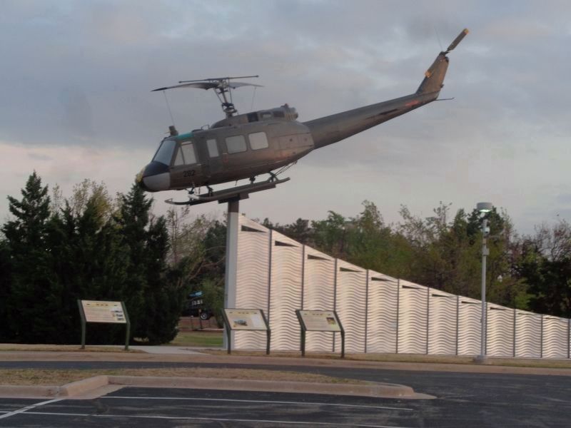
The helicopter quickly developed a nickname derived from its designation of Bell UH-1 series Iroquois, which came to be pronounced as "Huey." Typically, Hueys had crews of two officer pilots and two enlisted crew members acting as crew chief and . . . — — Map (db m172610) HM
The helicopter you see here is pitched slightly forward with the nose down and the rotors angled. This configuration was the most efficient for straight and level flight at 70 knots, or roughly 77 miles per hour.
The sight and sounds of Huey . . . — — Map (db m172724) HM
Before Oklahoma was inhabited by Europeans, people such as Captain Randolph B. Marcy were sent to explore and collect specimens of plants and animals. Since a map of Oklahoma did not exist at the time, the US government waned to know the source of . . . — — Map (db m174627) HM
Considered the most successful Choctaw entrepreneur, Robert M. Jones operated five cotton plantations in Texas, Louisiana, Arkansas, and Indian Territory from Rose Hill, his elegant mansion located west of Fort Towson. He owned an interest in a . . . — — Map (db m172731) HM
The Kiamichi River begins on Pine Mountain in LeFlore County, Oklahoma, and flows about 165 miles in a south by southwest direction to the Red River. The river's valley has provided a major transportation route through the Ouachita Mountains for . . . — — Map (db m172735) HM
In 1867, the Comanche, Kiowa, and Apache Indians accepted a reservation of more than three million acres in present-day southwest Oklahoma. Bounded on the west by the North Fork of the Red River and the east by the Chickasaw Nation, many of the . . . — — Map (db m174626) HM
"Dedicated to you, a free citizen in a free land." So began the presentation of the Liberty Bell replica from the US Treasury Department. Using donations from major American metal companies, the French Paccard Foundry cast 55 full-sized replicas of . . . — — Map (db m172583) HM
In 1852 Captain Randolph B. Marcy commanded a force consisting of 70 men to find the source of the Red River and to "collect and report everything that may be useful or interesting."
Guided by Sucktumaquay, or Black Beaver, of the Delaware . . . — — Map (db m174928) HM
The Arkansas Territorial Assembly created Miller County, Arkansas Territory, in April 1820. Originally it included much of southeastern Oklahoma. The 1820 Treaty of Doak's Stand encouraged Choctaw people living in Mississippi to move to the same . . . — — Map (db m172794) HM
An important Civil War innovation, the 3-inch ordnance rifle was produced from a complex build-up of wrought iron, roll welded and bored to create, at 816 pounds, a relatively light artillery piece, deadly accelerate to 1,850 yards or one mile and . . . — — Map (db m172635) HM
This stream enters Oklahoma in Beckham County and then flows southeast into the Red River. The Great Spanish Road to the Red River from Santa Fe, New Mexico to Natchitoches, Louisiana, followed the north shore of the Red River from the North Fork to . . . — — Map (db m174631) HM
About one mile north of the Red River in Bryan County, African Americans established the town of Oberlin in 1904. The majority were former slaves on the Robert M. Jones plantation. At its peak, the population of the community numbered 500.
One . . . — — Map (db m172950) HM
Oklahoma City Oil and Gas Field Discovery Well brought in December 4, 1928, approximately six miles southeast of this marker.
From such beginning, sprawling Oklahoma City Oil and Gas Field became one of world's major oil producing areas, . . . — — Map (db m59947) HM
The Oklahoma City Field is one of the giant fields of the world, having produced more than 735 million barrels of oil and more than 2 trillion cubic feet of gas from 26 producing zones through 1969. The ultimate recovery from this field is estimated . . . — — Map (db m161376) HM
The original boundary between Oklahoma and Texas was the south cut-bank of the Red River. The river's volatility combined with its sandy banks caused the boundary to shift frequently. Oil production in the river raised questions of Indian oil . . . — — Map (db m174617) HM
Encouraged by the tales of old Spanish and Mexican mines, prospectors found evidence of gold deposits in the Wichita Mountains near Fort Sill, Indian Territory, in the 1890s. Active mining was delayed until 1901 when the Kiowa, Comanche, and Apache . . . — — Map (db m174849) HM
Oklahoma's rise to prominence as a leading producer of oil, natural gas and refined products can be attributed in great measure to the determination and hardy spirit of its pioneers in the industry.
These were the wildcatters, the roughnecks, . . . — — Map (db m172585) HM
The 1819 Adams-Onis Treaty determined the United States-Spanish boundary to be the Red River to the 100th Meridian and extended north to the Arkansas River. Texas later claimed that the North Fork of the Red River, instead of the south or Prairie . . . — — Map (db m174929) HM
French claims on North American land go back to 1682 when Rene-Robert Cavelier Sieur de la Salle declared all the country associated with the Mississippi River and its branches. The land was named the Louisiana Territory in honor of King Louis XIV. . . . — — Map (db m172500) HM
Francisco Vasquez de Coronado y Lujan brought the Royal Standard of Spain in 1541 to the area now known as the Oklahoma Panhandle. Coronado and his band of conquistadors (conquerors) were in search of the mythical Cibola, or Seven Cities of Gold. . . . — — Map (db m172496) HM
San Bernardo was one of two Wichita villages in this area. The second village was situated south of the river. Located just west of the Cross Timbers on the eastern edge of the Great Plains, San Bernardo's residents had access to timber for firewood . . . — — Map (db m174618) HM
Welcome to the Red River Journey! Here is your passport to important facts about Oklahoma's fascinating history. Find each blue history marker with a medallion at the bottom left corner. Use a pencil or crayon and some paper to make a rubbing of . . . — — Map (db m174930) HM
First raised in 1839, the second flag of the Republic of Texas flew over the Oklahoma Panhandle until 1850, when the northern border of the Texas Panhandle was established. Between 1850 and 1890 the Oklahoma Panhandle, an area named No Man's Land, . . . — — Map (db m172576) HM
The Second National United States Flag, also known as the Stars and Stripes, appeared over Oklahoma in 1803. In that year the United States purchased the Louisiana Territory from the French for the sum of $15 million. All of Oklahoma, except . . . — — Map (db m172505) HM
This Spanish flag flew over Oklahoma in 1763 when France gave all of the land west of the Mississippi to Spain in the Treaty of Paris. The treaty ended the French and Indian War, the first global conflict. This Spanish flag is called the Cross of . . . — — Map (db m172503) HM
The Standard of the French Republic flew over all French territories in North America, including what is now Oklahoma. In 1800 Spain gave the area known as the Louisiana Territory back to France when French Emperor Napoleon Bonaparte reclaimed the . . . — — Map (db m172504) HM
In 1900 the western boundary of the Chickasaw Nation, the 98th parallel from the Red River to the Canadian River, served as the boundary line for the Twin Territories. Realizing the inevitability of statehood, leaders of different nations in Indian . . . — — Map (db m173145) HM
A steamboat is a large boat that uses steam for power. Many of these boats were used to transport supplies to soldiers and settlers all over the country in the nineteenth century. One sank in the Red River while it was bringing supplies to Fort . . . — — Map (db m172745) HM
The perils of navigation on the Red River are represented by the fate of the steamboat Heroine. The steamboat was carrying supplies including flour, pork, beans, candles, and salt for the garrison at Fort Towson. The Heroine had . . . — — Map (db m172797) HM
The 100th Meridian, Oklahoma's western boundary south of the Panhandle, was specified in the 1819 Adam-Otis Treaty between the United States and Spain. Surveys in 1858 and 1860 found that maps previously located that border one hundred miles too far . . . — — Map (db m174927) HM
Named for Cherokee trader, scout, and guide Jesse Chisholm, the Chisholm Trail was the first post-Civil War cattle trails. Although named for Jesse Chisholm the trail was in fact started by Sucktumaquay, or Black Beaver, of the Delaware tribe. At . . . — — Map (db m174616) HM
The Great Raft was a series of log jams that clogged the Red River for 160 miles, making navigation virtually impossible. The Great Raft created bayous, lakes, and unique ecosystems. The army determined to clear the raft and make the Red River . . . — — Map (db m172636) HM
The Red River Journey
The Red River area along the southern border of Oklahoma has been the site of events that shaped the history of the southern plains, the United States, and the world. American Indians hunted, traveled, traded and . . . — — Map (db m172722) HM
Welcome to the Oklahoma History Center's botanical gardens! We hope you enjoy the beautiful and diverse Oklahoma plants.
In 1937 the Redbud tree was named the state tree of Oklahoma. These trees have bright reddish-pink blossoms, and . . . — — Map (db m172747) HM
The Flag Act of 1818 established the basic design of the United States Flag used today with thirteen stripes representing the original thirteen colonies. Each star represented a state, and every time a state joined the Union a star was added to the . . . — — Map (db m172508) HM
After the death of Choctaw leader Pushmataha in 1824 and the signing of the Dancing Rabbit Creek Treaty in 1830, the US government forcibly removed the Choctaw Nation from Mississippi. Removal occurred in three stages along multiple routes and . . . — — Map (db m173135) HM
This statue was fashioned by
Constance Whitney Warren
Sculptress of Paris, France and New York,
and was presented to
The State of Oklahoma
by this distinguished American Artist
through the solicitation of
Justice Albert C. . . . — — Map (db m59952) HM
The Union Flag, or Flag of Great Britain, was adopted when the crowns of England and Scotland united in the early 1600s. This flag flew over Oklahoma in 1663 when Charles II of England gave a strip of land extending from the Atlantic Ocean to the . . . — — Map (db m172498) HM
During the 1920s Jackson County, Oklahoma, was a prolific cotton-producing area featuring dry-land farming techniques. Led by W.C. Austin, area leaders began advocating the creation of an irrigation project to enhance local agriculture. Construction . . . — — Map (db m174853) HM
Located near Cache Creek, Oklahoma, just north of the Red River, this trading post was one of several originally constructed by Holland Coffee in the 1830s. These posts were established to trade with the Plains Indians and to take advantage of . . . — — Map (db m174620) HM