1282 entries match your criteria. The first 100 are listed. Next 100 ⊳
National Historic Landmarks Historical Markers
Nationally significant historic places designated by the Secretary of the Interior because they possess exceptional value or quality in illustrating or interpreting the heritage of the United States. Today, fewer than 2,500 historic places bear this national distinction.
By Mark Hilton, January 14, 2017
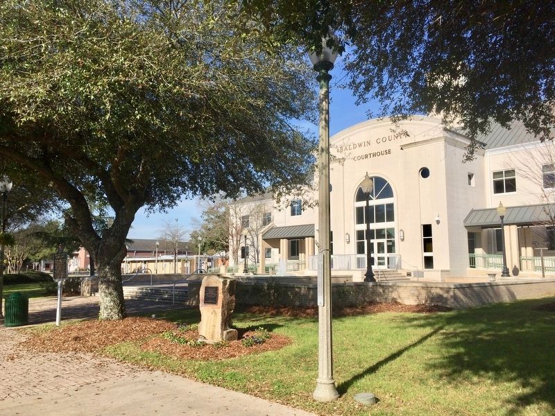
Bottle Creek Site Marker in front of Baldwin County Courthouse.
The Family Home of Captain Arthur M. & Kate Adams Keller was built 1820, being the second house erected in Tuscumbia.
Here on June 27, 1880 was born America's First Lady of Courage Helen Adams Keller — — Map (db m29089) HM
Brown A.M.E. Chapel (in front of you) served as a safe haven for supporters during the voting rights campaign. Pastor P.H. Lewis and his congregation courageously broke the injunction prohibiting African Americans from holding mass meetings, making . . . — — Map (db m131995) HM
Edmund Pettus Bridge
has been designated a
National Historic Landmark
This site possesses national significance for its
association with "Bloody Sunday," a seminal event in the
Civil Rights Movement. Here, on March 7, 1965, . . . — — Map (db m82037) HM
The demonstration that led to the most important advance in civil rights for millions of Black Americans began here March 21, 1965. It was the 50-mile march from Selma to Montgomery, Alabama, the State Capital.
Defying threats of death, Dr. . . . — — Map (db m83578) HM
Here stood
Fort Toulouse
A defense against
the Indians
Built by
Bienville
1714
The Alabama Society
of Colonial Dames
preserves the memory
of faithful service
1912 — — Map (db m69567) HM
Site of a prehistoric Native American political and ceremonial center from about A. D. 1100-1500 that, at its height in the 13th century, was America’s largest community north of Mexico. Between 1,000 and 3,000 people lived in this town fortified . . . — — Map (db m30700) HM
I do not think in the Southern States there is a group of Mounds to compare to Moundville, in the arrangement and state of preservation of the mounds.
- Clarence B. Moore, amateur archaeologist, 1910
Spanning more than . . . — — Map (db m144745) HM
1834 - Organized as mission by Rev. Caleb S. Ives for settlers coming here to the Canebrake from Atlantic Seaboard
1844 - made parish of Diocese of Alabama
1851 - this site selected
1853-54 - this building erected — — Map (db m38188) HM
Rev. Fred Shuttlesworth's tenure as pastor of Bethel Baptist Church (1953-1961) was marked by demonstrations, bombings and passionate sermons critical of segregation laws. His activism earned him a house bombing, frequent beatings, arrests, and . . . — — Map (db m83836) HM
Sixteenth Street Baptist Church
has been designated a
National
Historic Landmark
This property possesses National Significance in commemorating the history of the United States. In 1963 it was the staging ground for the . . . — — Map (db m63733) HM
The crossing of railroads in 1872 adjacent to this site gave rise to the industrial city of Birmingham. In 1881 Alabama railroad magnate and entrepreneur James Withers Sloss, capitalizing on the unusual coincidence of coal, iron ore and limestone in . . . — — Map (db m23498) HM
The blast furnace required a tremendous amount of air - about two tons for every ton of iron produced. These three rooms, known collectively as the blower building, house the equipment used to pump air to the furnaces. Workers called this blast of . . . — — Map (db m43628) HM
The Gas System
Gas produced in the furnace as a by-product of the ironmaking process was used in the plant as fuel. A large pipe called the downcomer carried gas from the top of the furnace to the gas cleaning equipment, which removed the . . . — — Map (db m43669) HM
Construction of Wilson Dam began in 1918 and was completed in 1924. The Dam is 137 feet high and stretches 4,541 feet across the Tennessee River.
Wilson Dam is a hydroelectric facility. It has 21 generating units with a net dependable capacity . . . — — Map (db m73997) HM
Used during the Apollo Lunar Landing Program of the 1960's and 1970's, the Saturn V rocket remains the largest, most powerful rocket ever built.
This full scale mock up was completed in July 1999 to serve as the focal point for the 30th . . . — — Map (db m85601) HM
The Church of the Nativity congregation was organized December 17, 1842 - the name chosen because of the approaching Christmas season. The Convention of the Diocese of Alabama, Protestant Episcopal Church, approved the congregation on February 16, . . . — — Map (db m27858) HM
Built 1842-1860 by Gen. Nathan Bryan Whitfield 1799-1868 accomplished planter of the Canebrake
using imported materials and artisans Glorifying the Greek Revival Architecture by combining Doric exterior
Corinthian grand ballroom Ionic parlor . . . — — Map (db m38068) HM
Founded, with 21 members, in 1831, by Rev. John B. Warren. This sanctuary erected 1834. Designated by the U.S. Dept. of the Interior as one of America's historic buildings. Presbyterian mother church for Southern Alabama. — — Map (db m116964) HM
Named for the State of Alabama. 6th naval fighting ship to bear the name. Built by the Norfolk Navy Yard, Portsmouth, Virginia. Authorized by Congress 27 March 1934. Keel laid 1 February 1940 – Launched 16 February 1942. Sponsored by . . . — — Map (db m74366) HM WM
Has been desiginated a
Registered National
Historic Landmark
Under the provisions of the
Historic Sites Act of August 21, 1935
this site possesses exceptional value
in commemorating and illustrating
the history of the United . . . — — Map (db m74156) HM
Alabama's First Capitals
On March 3, 1817, Congress designated the town of St. Stephens on the Tombigbee River north of Mobile as capital of the newly formed Alabama Territory. There in 1818, the territorial legislature named Huntsville as the . . . — — Map (db m86063) HM
The second black Baptist Church in Montgomery. First pastor was Rev. C. O. Boothe. Present structure built 1885. Designed by Pelham J. Anderson; built by William Watkins, a member of the congregation.
Many prominent black citizens of Montgomery . . . — — Map (db m25128) HM
Side 1
Named in honor of Judge Frank M. Johnson, Jr. (1918-1999), who served here as U.S. District Judge from 1955-1979, as U.S. Circuit Judge of the United States Court of Appeals for the Fifth Circuit July 12, 1979 - October 1, 1981, and . . . — — Map (db m71266) HM
Built during Creek War 1813 by Georgia Militia on main Indian trade route to Tombigbee River
U.S. Troops stationed here until 1837 1836 Lower Creeks corralled here for forced removal to the West — — Map (db m26069) HM
Fort Mitchell
Has Been Designated A
National Historic Landmark
This site possesses National significance in commemorating the history of the United States of America — — Map (db m241212) HM
Foster Auditorium is the site of the June 11, 1963, “stand in the schoolhouse door” by Governor George C. Wallace in defiance of a court order requiring The University of Alabama to admit African-American students Vivian Malone and James . . . — — Map (db m37917) HM
This site possesses national significance in commemorating the history of the United States of America. The hall is the place of importance in the native community. The original chapter of Alaska Native Brotherhood built this hall in 1914 to serve . . . — — Map (db m133827) HM
has been designated a
Registered National
Historic Landmark
under the provisions of the
Historic Sites Act of August 21, 1935
This site possesses exceptional value
in commemorating and illustrating
the history of the United . . . — — Map (db m181330) HM
has been designated a
Registered National
Historic Landmark
under the provisions of the
Historic Sites Act of August 21, 1935
This site possesses exceptional value
in commemorating and illustrating
the history of the United . . . — — Map (db m181596) HM
Saint Michael's Cathedral, a National Historic Landmark, is the central point of interest in historic downtown Sitka and is recognizable statewide as the most prominent symbol of the Russian colonial presence in Alaska. It was the main edifice of a . . . — — Map (db m181574) HM
This large frame house was constructed as a Russian residence about 1835. Although there has been some modification the building is thought to be the finest remaining example of Russian secular architecture in Alaska. — — Map (db m133829) HM
This building was the general office for the Bisbee operations of Phelps Dodge Corporation from 1895 to 1961.
In 1971 it was given to the City of Bisbee by Phelps Dodge and was designated as a National Historic Site by the National Park . . . — — Map (db m28275) HM
Has been designated a
National
Historic Landmark
This site possesses National significance
in commemorating the history of the
United States of America
1964 — — Map (db m28301) HM
At this location in 1952, a large bone bed was discovered containing the remains of extinct mammoth, tapir, bison and horse. Found with the bones were the weapons and tools of the Indians who had killed and butchered these animals. The bones and . . . — — Map (db m43633) HM
Situated on the southern route to the Pacific Ocean, it brought law and order to the Arizona Territory, protecting settlers, miners, travelers and immigrants. Its troops won the surrender of Geronimo. Generals Pershing and Wood served here.
As . . . — — Map (db m27897) HM
Architect Frank Walker designed this building in Victorian style adapted to Western Territorial. It is constructed of fired red brick. It has been in continuous service since 1882 for Mayors, Marshals and official city offices. In the 1880s it . . . — — Map (db m27918) HM
Lowell Observatory has been designated a Registered National Historic Landmark Under the provisions of the Historic Sites Act of August 21, 1935 this site possesses exceptional value in commemorating or illustrating the History of The . . . — — Map (db m149455) HM
1956 Grand Canyon TWA-United Airlines Aviation Accident Site has been designated a National Historic Landmark.
This tragic accident site represents a watershed moment in the modernization of America's airways leading to the establishment of . . . — — Map (db m81861) HM
Hopi House opened on January 1, 1905, the first Grand Canyon work of architect Mary Colter. To complement El Tovar, their new hotel, the Fred Harvey Company commissioned Colter to design a building to display and sell Indian arts and crafts. Colter . . . — — Map (db m39478) HM
The Fred Harvey Company built Lookout Studio in 1914, in part to compete with the Kolb Brothers Studio located slightly west along the rim. Called "The Lookout," Fred Harvey's studio offered telescopic views, photographs, and books about the . . . — — Map (db m39544) HM
"Won't you be one of the 25,000 visitors at the Grand Canyon of Arizona this summer? It is the world's scenic wonder - nothing like it."
Santa Fe Railroad brochure, 1914.
The Santa Fe train whistle that was heard here on September 17, . . . — — Map (db m39569) HM
Build a structure that provides the widest possible view of Grand Canyon yet harmonizes with its setting: this was architect Mary Colter's goal when the Fred Harvey Company hired her in 1930 to design a gift shop and rest area here at Desert View. . . . — — Map (db m39616) HM
Originally this building stood at Red Horse, 25 miles south of the Grand Canyon, where it was possibly used as one of the stage stops between the Grand Canyon and Flagstaff. In 1902, Ralph Cameron had it moved to its present site, where, with the . . . — — Map (db m236357) HM
For Mary Colter, [Hopi Housel was an opportunity to re-create the distinctive dwelling of an ancient culture and to acquaint the public with the richness and beauty of Native American art. – Virginia Grattan, Mary Colter: . . . — — Map (db m236334) HM
Your visit and rest here is part of a long tradition started in 1914 with the opening of Hermits Rest. After an 8-mile (13 km) buggy ride, you would be greeted by the resident caretaker and offered a refreshing drink to clear the dust from your . . . — — Map (db m108881) HM
Taliesin West, as part of the 20th-Century Architecture of Frank Lloyd Wright, has been inscribed on the World Heritage List.
Inscription confirms that this property deserves protection for the benefit of all humanity because of its . . . — — Map (db m188806) HM
On January 24, 1923 an act was passed by Congress authorizing the Secretary of the Interior to establish and maintain an Indian boarding school on the site of Fort Apache. The first students were Dine' (Navajo) children brought from the Navajo . . . — — Map (db m36876) HM
Has been designated a
National Historic Landmark
This site possesses national significance
in commemorating the history of the
United States of America
1964 — — Map (db m36885) HM
Tucson Air Museum Foundation
of Pima County
Titan II Intercontinental Ballistic Missile Museum
Established May 8, 1986
571st SMS, 390th SMW
Davis-Monthan AFB
Strategic Alert July 1963 – November 1982
National . . . — — Map (db m26926) HM
The first Pima County Courthouse, a single-story adobe structure built in 1868, was replaced in 1881 by a large two-story stone and red brick victorian building which, in turn, was removed in 1928 to make way for the present structure. This . . . — — Map (db m55222) HM
Mission San Xavier del Bac was founded by the Jesuit missionary, Fr. Eusebio Kino in 1692. The present church was built under the direction of the Franciscans. Construction began in 1783 and was completed in 1797.
The church continues to . . . — — Map (db m83206) HM
Beginning and History
In January of 1691, at the request of the O'odham (Pima) Indians of the Santa Cruz River Valley, Jesuit Father Eusebio Francisco Kino established the mission of Tumacácori, dedicated to Saint Cajetan (San Cayetano). . . . — — Map (db m68149) HM
The first mining claims were filed in 1876, within 20 years Jerome was a billion dollar copper mecca and one of the wildest, wickedest mining towns in the west. Drinking, gambling, brawls and frolicking with ladies of the night occurred . . . — — Map (db m33149) HM
From 1850 to 1877 all travelers crossing the Colorado River used the ferry. Several operated between the mouth of the Gila River and Pilot Knob. Steamboats arrived on the river in 1850 and the first railroad bridge was built in 1877. — — Map (db m29015) HM
Yuma Crossing, used since prehistoric times, played a significant part in the development of the West and continues to influence the affairs of the state and the nation. The Yuma City-County Bicentennial Commission in the spring of 1974 conceived . . . — — Map (db m28984) HM
Plaque Rohwer Relocation Center Memorial Cemetery Has Been Designated A National Historic Landmark This Site Possesses National Significance In Commemorating The History Of The United States of America 1992 . . . — — Map (db m167617) HM
This stone marks the base established Nov. 10, 1815
from which the lands of the Louisiana Purchase were surveyed by the United States Engineers. The first survey from this point was made to satisfy the claims of the soldiers of the War of 1812 . . . — — Map (db m6037) HM
This park preserves and protects two of Arkansas's greatest heritages: The "initial point" of the 1815 Louisiana Territory land survey and one of the state's few "headwater" swamps. The elevated boardwalk allows for safe viewing of the park's . . . — — Map (db m155180) HM
This point was established by survey on November 10, 1815 by U.S. Government survey teams led by Prospect Robbins and Joseph Brown. Recognizing the national significance of this Initial Point, the L'Anguille Chapter of the DAR sought placement of a . . . — — Map (db m155200) HM
The stone marker behind you marks the 'Initial Point' for the survey of the Louisiana Purchase Territory. The east-west Baseline and the north-south line, the Fifth Principal Meridian, are fundamental in land transactions throughout the western . . . — — Map (db m155199) HM
At about 9:30 a.m. Federal
patrols made contact with
Confederate scouts near Poison Spring. Colonel Williams
parked his wagons two and
three abreast, as close together
as possible. He ordered the
First Kansas to the front forming a line, and . . . — — Map (db m201023) HM
Critical Shortage of Food and Forage...
More than three weeks of marching
and fighting depleted Steele's sup-
plies. His troops had been on half
rations for more than two weeks and
unauthorized foraging was widespread.
The capture of . . . — — Map (db m201020) HM
Williams, despite being outnumbered, defended the train as long as possible,
hoping for reinforcements from Camden. After a short and hotly contested
engagement at close range, the black troops broke ranks, retreating in chaos.
The Confederates . . . — — Map (db m201024) HM
The Federal government's unsuccessful Red River Expedition in April, 1864 was the last major invasion of Confederate territory west of the Mississippi River. Its aim was to capture Shreveport, Louisiana, open Texas to Federal occupation and acquire . . . — — Map (db m201019) HM
On April 1, 1942, sixteen B-25 bombers were hoisted to the flight deck of the carrier Hornet and parked there, while moored at Pier No. 3 at U.S. Naval Station in Alameda. The B-25 detachment consisted of seventy officers and one hundred thirty . . . — — Map (db m29431) HM
Roof replacement, accessibility, and seismic improvements: Architectural Resources Group and Degenkolb Engineers, 2007
City of Berkeley Landmark
designated 1975
Maybeck’s masterpiece is an Arts & Craft fusion of Romanesque, early Christian . . . — — Map (db m55032) HM
”The principle street of Coloma was alive with crowds of moving men, passing and repassing, laughing, talking, and all appearing in the best of humor. It was a scene that no other country could ever imitate.”
from “A . . . — — Map (db m12274) HM
National Historic Landmark
This site possesses national significance in commerating the history of the United States of America.
1964
National Park Service
United States Department of the Interior — — Map (db m32570) HM
In the early part of the World War II, 110,000 persons of Japanese ancestry were interned in relocation centers by Executive Order No. 9066, issued on February 19, 1942.
Manzanar, the first of ten such concentration camps, was bounded by . . . — — Map (db m122703) HM WM
This District possesses national significance in commemorating the history of the United States Of America.
The Coso Rock Art District contains the largest concentration of unaltered prehistoric petroglyphs and associated sites in North . . . — — Map (db m196327) HM
The Forty Acres has been designated a
National Historic Landmark.
This property possesses national significance
in commemorating the history of the
United States of America.
Forty Acres embodies and conveys multiple layers of national . . . — — Map (db m54836) HM
Discovered by Joseph R. Walker, American trail-blazer who left the San Joaquin Valley through this pass in 1834. This area was traversed by topographer Edward M. Kern, after whom the Kern River was named, while accompanying the Fremont expedition of . . . — — Map (db m159834) HM
Mining Tycoon L. Bradbury Makes His Mark
His name endures in the eponymous town of wealth and horseflesh set against the San Gabriel Mountains, but mining tycoon Louis Bradbury made his loveliest mark on Southern California with the . . . — — Map (db m167742) HM
Los Angeles Hompa Hongwanji Buddhist Temple,
built 1924-26.
Declared
October 24, 1986
Historic-Cultural Monument No. 318
by the
City of Los Angeles
Cultural Heritage Commission,
Cultural Affairs Department.
(second marker:) . . . — — Map (db m231223) HM
The Union Church, built in 1922, has great historic significance as
the first Christian church built in Little Tokyo, and the site of important
spiritual, cultural, and community service activities. It is listed on the
National Register of . . . — — Map (db m234531) HM
U.S. Post Office and Court House
has been designated a National Historic Landmark.
This property possesses national significance
in commemorating the history of the
United States of America.
This U.S. District Court House is . . . — — Map (db m229663) HM
Hollyhock House, as part of the 20th-Century Architecture of Frank Lloyd Wright, has been inscribed on the World Heritage List.
Inscription on this List confirms that this property deserves protection for the benefit of all humanity because . . . — — Map (db m154492) HM
Angelus Temple, founding church of International Church of the Foursquare Gospel, has been designated a National Historic Landmark. This building possesses national significance in commemorating the history of the United States of America. — — Map (db m219917) HM
Eames House has been designated a National Historic Landmark. This property possesses national significance in commemorating the history of the United States of America.
The Eames House was the creation of prolific designers Charles and . . . — — Map (db m211205) HM
Panel 1:
1945:
March: Lane Victory is named for the former slave, Isaac Lane, founder of Lane College, in Jackson, Tennessee. The Victory Ship was one of a class of cargo ships designed and built during World War II by the . . . — — Map (db m131429) HM
Neutra Studio and Residences has been designated a National Historic Landmark. This property possesses national significance in commemorating the history of the United States of America.
The Neutra VDL Demonstration Studio and Residences are . . . — — Map (db m120934) HM
This stadium was originally completed in 1923. It was partially redesigned and enlarged for the 1932 Olympic Games. Both designs were by architects John & Donald B. Parkinson. The Coliseum has witnessed many important sports, political, and . . . — — Map (db m116751) HM
Baldwin Hills Village
has been designated a
National Historic Landmark.
This residential complex possesses national significance
in commemorating the history of the
United States of America.
Reginald Johnson with Lewis Wilson, Edwin . . . — — Map (db m175168) HM
Panel 1: Watts Towers
California Historical Landmark No. 993
Panel 2:
Unconventional Life, Unconventional Art
Simon Rodia has been referred to as a visionary and a man of great passion. A self-taught laborer from . . . — — Map (db m51953) HM
Upton Sinclair House has been designated a Registered National Historic Landmark under the provisions of the Historic Sites Act of August 21, 1935.
This site possesses exceptional value in commemorating or illustrating the history of the United . . . — — Map (db m145405) HM
Hale Solar Laboratory has been designated a National Historic Landmark. This property possesses national significance in commemorating the history of the United States of America. — — Map (db m152145) HM
1282 entries matched your criteria. The first 100 are listed above. Next 100 ⊳