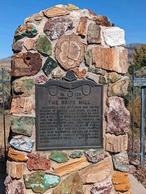
No. 255
Erected 1959
The Grist Mill
Minersville was settled in 1859 for the purpose of opening lead mines. Nelson S. Hollingshead built a grist hill on this site in 1871. It was operated by water diverted from the Minersville . . . — — Map (db m240540) HM
1st City Council:
J. Frank Smith - Mayor
Council Members:
Laban Burt • Arch Hoopes • Philo Boyter • Levi Howd
Burnett Swindlehurst • Sadie Patterson - City Recorder
2nd City Council:
Homer D. Thompson - Mayor
Council Members:
Laban . . . — — Map (db m286683) HM
Dedicated to the Two Hundredth Anniversary of the United States of America and sponsored by the Utah American Revolution Bicentennial Commission and Beaver Daughters of Utah Pioneers
Determined to preserve this historic courthouse, the Beaver . . . — — Map (db m274182) HM
The Beaver Opera House, built between 1908 and 1909, helped mark the beginning of the local citizens’ desire to build a “New Beaver” that would be the envy of other communities. The board of directors of the opera house were quoted as saying . . . — — Map (db m1429) HM
Built in 1896, the Beaver Relief Society Hall is one of only two buildings in Beaver associated with the Relief Society, the organization for women in the Church of Jesus Christ of Latter-day Saints. The building was used for general gathering . . . — — Map (db m75580) HM
On this site in 1865-66 a tabernacle was erected by the pioneers. Built of local brick, lumber and stone. It was of pioneer architecture with a large assembly hall, gallery, full basement, a tower and large bell. This building was used for church . . . — — Map (db m75614) HM
Beaver Territorial Courthouse is considered one of the finest examples of Pioneer architecture. The architect, K.A. Kletting, designed the building in the Queen Ann style with Victorian overtones. The courthouse was constructed under the direction . . . — — Map (db m75581) HM
This early sawed log farm cabin (circa 1890-1900) was relocated to this site from the small hamlet of Manderfield located 5 miles north of Beaver. Manderfield was known as Indian Creek in pioneer days. The Beaver Chapter of the sons of The Utah . . . — — Map (db m127201) HM
The Enoch E. Cowdell house, named after the original owner, was constructed around 1873 with a hall parlor type floor plan. Although the hall parlor was one of the earliest housing types in Utah, it continued to be a popular floor plan (particularly . . . — — Map (db m75572) HM
Established as the post of Beaver, May 15, 1872, by the 8th U.S. Infantry, Major John D. Wilkins, commanding. The military reservation, declared May 12, 1873, comprised two and two-thirds square miles. The name was changed July 1, 1874, to Fort . . . — — Map (db m75575) HM
In 1872-73 a two and two-thirds mile square, protective military reservation was established following the request of C.M. Hawley, Associate Justice, Utah Territory. Built of native rock and lumber, it received 250 troops Sept. 7, 1873, Major John . . . — — Map (db m75578) HM
Built By:
Duckworth Grimshaw, 1877
Registered By:
The Harley Fotheringhams,
1/12/72
Construction Notes
Original Portion Built
of Black Volcanic Rock
— — Map (db m75574) HM
The house was built c. 1877 for Joseph Tattersall, an early settler of Beaver City. It is a one-and-a-half-story tall building constructed of black rock--a hard, dense volcanic stone that is commonly found in the nearby foothills in small . . . — — Map (db m75573) HM
Hostile Indians raided a small settlement in this vicinity Oct. 27, 1866, centering their attack on the house where Mr. and Mrs. J.P. Lee, their two daughters, and eight year old son, a young Miss Hall and Joseph Lillywhite were barricaded, fighting . . . — — Map (db m75616) HM
Philo Taylor Farnsworth was born August 19, 1906 in a log cabin near Beaver, Utah. At an early age, he became familiar with the various components of the telephone and the gramaphone. By age 12, he had a thorough understanding of electronics. In . . . — — Map (db m1421) HM
Near this site, Feb. 6, 1856, in zero weather, Beaver pioneers made their first camp. Prior to this, the land had been rejected as unfit for cultivation, but the amount of water available gave courage. At a mass meeting in Parowan some of the more . . . — — Map (db m75615) HM
Dedicated to the memory of the valiant pioneers who erected the first woolen mills in Southern Utah in 1870. It was a busy mecca, with wagons coming and going from all over the State with their goods to trade. — — Map (db m75576) HM
This house was built circa 1883 for Robert and Sarah Stoney. The Stoneys were natives of England, immigrated to the United States in 1860, and made their way to Beaver in 1880. Robert worked as a silversmith, helped start the First Brass Band in . . . — — Map (db m274191) HM
This monument erected by the people of Beaver County to honor the men from this county who served their country during the World War
The funds were contributed by Beaver County and popular subscription
In the lists of names on these . . . — — Map (db m274188) WM
On this site in 1870, in a three story building, 60 x 120 feet, the first Woolen Mills in Southern Utah operated. Machinery was brought here from New England by railroad and wagon. John Ashworth and others schooled in England in the art of wool . . . — — Map (db m75577) HM
This house was constructed in three sections by Thomas Frazer, the local stonemason, as his own home. The middle section (1870) and the east section (1872) are built of black basalt. The west section (c. 1890) is constructed of pink tuf. Thomas . . . — — Map (db m75570) HM
This wagon is a reproduction of the wagons used by the Mormon Settlement to travel from Omaha Nebraska to Salt Lake City Utah. It traveled the entire trail in 1997 being navigated by Vern & Carol Condie sponsored by the Beaver County Travel Council . . . — — Map (db m274186) HM
Completed April 12, 1867, by direction of Brigham Young, with L.D.S. Church funds, as a travelers way station and refuge from Indians. Ira N. Hinckley built and maintained it as a hostelry and residence until 1877. A well within the fort provided . . . — — Map (db m75519) HM
The first settlers in this area were the family of Charles W. and Eleanor Willden. They were English converts to the Church of Jesus Christ of Latter-day Saints who had come to Utah in 1849. Because Charles was an iron worker, Brigham Young . . . — — Map (db m75518) HM
A typical mining town at the foot of the San Francisco Mountain was fed by the fabulously rich Horn Silver Mine. By 1885 over $60,000,000 in zinc, copper, lead, silver, and gold were hauled away by mule train and the Utah Central Railroad. Water was . . . — — Map (db m78264) HM
In 1884 this building was built by local craftsmen, carpenters, and brick masons
using local materials.
It was used as a school, church, and town meeting house.
The building was used for education, church services, weddings, funerals, . . . — — Map (db m274194) HM
In 1860 Samuel Edwards, George Horton, William Richards and David Miller with their
families came from Parowan and Cedar City and settled on Dry Creek. Soon others followed. Homes were built of logs, rock, and adobe. The meadows were covered with . . . — — Map (db m274195) HM
The Milford stamp or A.G. Campbell mill was erected in the fall of 1873 at a cost of $45,000. It was designed to work the ores of the Old Hickory Mine. In 1873-74 the mill ran successfully for five months. They used a 60 horse power engine, two . . . — — Map (db m240533) HM
Milford’s Historical Park
1974-2022
Milford's beautiful Historical Park had its beginning in 1974 when Milford's Historical Society was formed with Gladys Whittaker as its founder and first president. The Historical Society as soon as it . . . — — Map (db m240536) HM
In appreciation of all those who have served, and continue to serve, to defend and preserve peace and democracy throughout the free world.
(names not transcribed) — — Map (db m274197) WM
The Lincoln Mine
No. 17
Erected March 20, 1937
First lead mine in Utah
Five miles N.E. of here, discovered 1858, by Isaac Grundy, Jesse Smith, Tarlton Lewis and Wm. Barton. These men and Sidney Tanner,
John Blackburn, Edwin . . . — — Map (db m240538) HM
In 1866 a group of Mormon Scandinavians were called by the Latter-day Saint Church to establish this settlement and develop an irrigation project from the waters of the Malad River. Their first homes were dugouts built in the west bank of the Bear . . . — — Map (db m276901) HM
In 1866 a group of Scandinavian Latter-day Saints entered the area that would become Bear River City. Their first homes were dugouts on the west bank of the Bear River. These dugouts were roofed with poles, willows, straw, and dirt. The fall of 1867 . . . — — Map (db m276902) HM
In commemoration of the founders of this community who made their first homes in the banks of the Bear River in the winter of 1866. To the residents of the old fort and all other pioneers who resided in Bear River City and came to Utah prior to May . . . — — Map (db m278592) HM
A house, built in the fort in 1867, first served this community as a school, William Crosley
teacher, night classes were held for adults. A tithing granary was also used for school purposes. In 1885 one large room, built of rock was constructed and . . . — — Map (db m276904) HM
The Box Elder Cooperative Association was established in 1867 -68 by Lorenzo Snow, under direction of Brigham Young. In 1871 a dairy, said to be the first in Utah, was built south of Beaver Dam, near a cold water spring, Christian Hansen, operator. . . . — — Map (db m44467) HM
The Knudsen cabin, built by Porter Squires for Wilhelm and Laura Amelia Knudsen in 1855, was one of the first permanent structures in Brigham City. Located on the corner of First East and First South, the original cabin was 14' x 18'. It had a loft . . . — — Map (db m240501) HM
This is the site of the Baron Woolen Mills. The mill was built in 1871 under the direction of Lorenzo Snow as part of the Brigham City Mercantile and Manufacturing Association.
Tragically, the mill burned to the ground in 1877. It was quickly . . . — — Map (db m278584) HM
Site number 55
In July 1853 Brigham Young ordered the people settled in the Brigham City vicinity, construct another fort to provide protection from the Indians. This fort extended North and South about 15 rods and East and West about 8 rods. . . . — — Map (db m240494) HM
SITE NUMBER 74
Brigham City was the first important Mormon community to organize fistle for cooperative activity under a system later incorporated in the United Order of 1874. Approximately 30 or 40 industry branches were established with the . . . — — Map (db m240503) HM
The mercantile store was the last building constructed for the Brigham City Co-op. Three years after the store opened, a fire broke out. Financial losses from the fire shut down the business a year before the cooperative organization closed. . . . — — Map (db m105251) HM
Constructed in 1909 at a cost of about $7000, this building original housed the city fire department on the main floor and city offices on the second floor. It also had a jail in the southeast corner and "hobo apartments" in the basement. This was . . . — — Map (db m105252) HM
This stately building is one of the finest examples of nineteenth century Latter-day Saint architecture. For more than a century, it has served as a center of Christian worship; cultural enrichment, and community activities. Towering above the . . . — — Map (db m278150) HM
In 1942, Bushnell General Hospital was built in Brigham City by the federal government to treat World War II wounded. The hospital closed in 1946 after 13,000 army personnel were treated there.
In 1950, the Bureau of Indian Affairs coverted . . . — — Map (db m240490) HM
This monument marks the S.E. corner of fort built by Anson Call and associates in 1855 under direction of President Brigham Young as protection against Indians. The fort was the most northerly outpost in Utah. It was one hundred twenty feet . . . — — Map (db m152317) HM
In commemoration of the outstanding service he rendered the intermountain west as Patriot, Pioneer, Colonizer, Church leader, and Statesman on this plot of ground Aug 19th, 1877 he delivered his last public address when he organized the Box Elder . . . — — Map (db m152538) HM
First Ward Meeting House-
Built 1884-1886
Built as an LDS meeting house this is the oldest church still standing in Brigham City. It was made of stone, and a wooden recreation hall was later added to form a T with the main building.
. . . — — Map (db m278148) HM
In 1876, Harriet Snow, Box Elder Stake Relief Society President, was asked by the LDS General Relief Society President, Emmeline B. Wells, to join with women's groups throughout the LDS Church to gather and store wheat against a time of need from . . . — — Map (db m240493) HM
The first transcontinental railroad, that tied the West to the East with bands of steel, was completed with the driving of the golden spike at Promontory
Utah 33 miles west of here May 10, 1869. The railroad was abandoned with the ceremonial . . . — — Map (db m240499) HM
Lorenzo Snow was born 3 April, 1814, in Mantua, Ohio, a son of Oliver and
Rosetta Snow. He joined the Church of Jesus Christ of Latter Day Saints in June of 1836 at the age of 22. He crossed the plains, captained his wagon company, and arrived . . . — — Map (db m249866) HM
The same sun, moon and stars shone over these everlasting hills when old Lake
Bonneville's waters reached midway up these mountains. Later, native American
hunters roamed these lands which they called Woebequachee. Here they fished Pe-
Ogway . . . — — Map (db m240491) HM
Soon after the first white families settled at Box Elder, they built a temporary fort to protect themselves from Shoshone Indian attacks.
The Davis Fort was named after their leader, William Davis and consisted of a row of simple log . . . — — Map (db m240496) HM
4-Union Pacific Depot - Built 1907
The depot served thousands of train passengers over the years. The trains also handled shipments of coal locally grown produce and mail.
During World War II, a track was installed between the depot . . . — — Map (db m240498) HM
Ford was used by Indians, Fur Tappers and Mountain Men. About 1853 Ben Hampton and Wm. Godbe operated a ferry for emigrant traffic. The site became a "home station" successively for stages of Oliver & Conniver, Ben Holladay, and Wells-Fargo. About . . . — — Map (db m105494) HM
"...we came to Bear River Crossing, ... There has been a ferry established here all summer until the later week, when the waters have become so much fallen that it renders it useless The river is now about 150 ft. wide, an average depth of 2 1/2 . . . — — Map (db m105495) HM
"We now skirted the north end of the lake, sometimes traveling in a valley and again along the shore of the lake where the mountains jutted down nearly to its shores." -- Nicholas "Cheyenne" Dawson, narrative, August 26, 1841 — — Map (db m105300) HM
Look down this path toward the sharp V-shaped notch in the shoulder of the mountainside ahead. Walking the Big Fill Trail, you can still see some of the violent fury of the final days of the race to Promontory, carved into unyielding limestone. . . . — — Map (db m171363) HM
This 1.5 mile round-trip route leads to two of the most significant railroad
construction features in the Promontory area - the Central Pacific's Big Fill
and the Union Pacific's Big Trestle site. The trail is easy to walk, thanks to the
two . . . — — Map (db m171369) HM
Mile 762.7 from San Francisco
Information about this siding is limited to ambiguous notations amending Central Pacific RR survey plats and profiles.
Onsite investigations have revealed no evidence of occupation. — — Map (db m105299) HM
Ancient Lake Bonneville once covered this area, including the flanks of Promontory Range. The waves washing against the ancient shore eroded fault-fractured rocks, creating the arch in the 300-million-year-old Oquirrh Formation.
More than . . . — — Map (db m171373) HM
Lacking precise instructions from Congress as to where to meet, and spurred by financial rewards for building grade, both railroad companies prepared railbed past each other for 250 miles. No parallel track was ever laid.
Promontory Summit was . . . — — Map (db m80934) HM
Looking toward the immediate completion of the first Transcontinental Railroad, Corinne Townsite was laid out in the Spring of 1869.
Railroad Financiers, Real Estate Promoters, Businessmen & Gambling Sharks, launched a boom to make Corinne the . . . — — Map (db m117001) HM
1870
This is the oldest extant Protestant Church building in Utah.
It was dedicated by
Chaplin C.C. McCabe and
Reverend G.M. Peirce on
September 20, 1870 — — Map (db m105257) HM
On this site the Corinne Opera House, for many years the largest recreation center in Utah outside of Salt Lake City, was erected in 1879. Built of red pine lumber with square nails, the leading stock companies, California bound on the new railroad, . . . — — Map (db m105258) HM
Helping to Build a Nation Steel production increased rapidly in the United States after
the Civil War. Prior to the war, the United States had not
produced one single steel rail. By 1873, it had produced nearly
115,000 tons of steel . . . — — Map (db m172235) HM
For four years Americans closely followed the progress of the Pacific railroad in their newspapers, anxious to see it completed. By May 1869, intense attention was focused on this desolate corner of northern Utah. The entire country was eager for . . . — — Map (db m171374) HM
A rough crowd had gathered at the far set of tracks 15 yards ahead. Six million spikes and six years’ work lay behind them. Now, only one section of rails was left undone. The honor of ceremonially “finishing” the Pacific railroad with a . . . — — Map (db m80931) HM
With an officer of the Twenty-first U.S. Infantry posed on the completed tracks and men of his regiment behind him, dignitaries of the Union Pacific Railroad stand for a photograph. Dr. Thomas C. Durant, Union Pacific Vice-President, is seen , at . . . — — Map (db m80940) HM
In this photo, taken one day before the transcontinental line was completed, a 30-foot gap in the railroad remained. A tent town quickly grew around the Last Spike Site, and two of the first businesses, the Restaurant and the Red Cloud Saloon can be . . . — — Map (db m80939) HM
Mile 748.6 from San Francisco
Monument was little more than a siding and wye for the railroad, with little evidence remaining today of the railroad era.
Its name came from Monument Point, a prominent landform visible from here. Photos from . . . — — Map (db m105301) HM
Spanning a Continent
The Pacific Railroad Act of 1862 mandated that
American-made iron be used to fabricate all rail for
the transcontinental railroad. Although steel was more
durable, it was not widely available in the United . . . — — Map (db m171384) HM
The Presbyterian work in Utah began at Corinne June 11, 1969 under Rev. Melancthon Hughes, sent here by Rev. Sheldon Jackson, missionary and educator. This bell was later given to the first congregation. In the first century, the Presbyterians . . . — — Map (db m105261) HM
Mile 765.0 from San Francisco
This site was christened Victory on April 28, 1869 when Central Pacific Workers rested for lunch after laying six miles of track during the famous laying of ten miles of track in a day. The site was later named . . . — — Map (db m105297) HM
The transcontinental railroad was a commercial link which opened new markets and figuratively united the nation with bands of rail. Seen here are Union Pacific Railroad fruit cars en route to California to be loaded with perishables for Eastern . . . — — Map (db m80938) HM
Four months after completion, Promontory was a notorious boomtown composed of hotels, saloons, and gambling tents with a few stores and shops. Transcontinental passengers changed trains here until mid-1870. Many were victimized by resident gamblers . . . — — Map (db m80942) HM
After the opening of the Lucin Cutoff in 1904, the historic rail line north of the Great Salt Lake was of minimal importance. In 1942 the last spike was ceremonially “undriven” here before a crowd of Union Pacific, Southern Pacific, and . . . — — Map (db m80941) HM
Spiral Jetty is an earthwork sculpture constructed in April, 1970 that is considered to be the central work of American sculptor Robert Smithson (1938-1973). Built on the northeastern shore of the Great Salt Lake near Rozel Point in Utah entirely of . . . — — Map (db m223247) HM
The cut below you on the Union Pacific grade is a good example
of the stair step construction method used by the railroads. The
workers were set to grading, scraping and blasting on several
different levels of a cut at once. This method . . . — — Map (db m100047) HM
You are now standing on the historic railbed and to your right at the gate that separates the old railbed from the highway, the Southern Pacific covered an old trestle with fill on the steepest grade on the Promontory Mountains. For years helper . . . — — Map (db m80956) HM
Competing for fame and money, the two railroads constructed over 250 miles of parallel grade. Here the Central Pacific built the Big Fill before Congress gave final construction rights to the Union Pacific. Afterward, the U.P. sold the tracks . . . — — Map (db m80957) HM
Lacking time to fill the ravine before you, Union Pacific crews built the bridge shown in the photo. One reporter said that nothing he could write “would convey an idea of the flimsy character of that structure.”
You can still see the . . . — — Map (db m80958) HM
In 1870 the first U.S. Government weather station in Utah was erected on this site by the War Department Signal Service, U.S. Army Division of Telegrams and Reports, for the benefit of commerce. The observer was William W. McElroy. The station was . . . — — Map (db m105253) HM
By April of 1869, the Union Pacific was working its Mormon and Irish labor forces day and night in order to meet the scheduled deadline for the completion of the railroad. Below you is the last cut made along the transcontinental route. Cuts such as . . . — — Map (db m80952) HM
”More representative American locomotives of the period would be difficult to find. Both the Jupiter and 119 were of the eight wheel or 4-4-0 wheel arrangement. This style of engine was so common in the United States that it was called the . . . — — Map (db m80965) HM
“The original Jupiter and No.119 were scrapped at the turn of the century. Despite their absence, the replica locomotive tell the story of the building and significance of the nation’s first transcontinental railroad. Today’s . . . — — Map (db m80966) HM
A sharp eye can still pick out the marks of early railroad building along this rugged escarpment, even if the original iron rails and timber ties themselves are gone.
These fading remnants tell the story of a daunting engineering . . . — — Map (db m69108) HM
Welcome to the Transcontinental Railroad National Back Country Byway. The railroad grade you will be driving represents an epic achievement in American history, linking East to West in a new nation. Today, the landscape looks much the same as it did . . . — — Map (db m100000) HM
Not only did the Railroad Act of 1862 lay out a grand plan of connecting the continent by rail, but the legislation called for a communication transformation as well. A telegraph line was to be strung along the transcontinental route ushering in an . . . — — Map (db m125276) HM
This bell was brought to Corinne by Hyrum House to warn the community at times when the water was to be shut off. In 1896 it was used to ring in Statehood for the State of Utah. It was rung so hard that day, that it cracked, then was placed on a . . . — — Map (db m155256) HM
As you look down the historic Bear River, imagine Indians, fur traders, explorers, and emigrants grazing their animals in the lush river bottom. During the gold rush, the Salt Lake Cutoff crossed the Bear River here on its way to rejoin the . . . — — Map (db m278714) HM
Built in 1914, the Garland Carnegie Library is one of 23 Carnegie libraries in Utah and one
of over 1650 library buildings in the United States that were built by
millionaire/philanthropist Andrew Carnegie. Carnegie donated the entire cost of . . . — — Map (db m286274) HM
To settle a wager among the trappers who were making their first winter rendezvous in Cache Valley, Bridger floated alone in a bull boat down Bear River to its outlet to determine the river's course in the late autumn or early winter of 1824, thus . . . — — Map (db m152315) HM
When the railroads were first moving across the country, they needed water for their steam engines. The Lucin ponds were developed in the 1800’s for this purpose. The water to fill the ponds comes through a pipeline from the Pilot Mountain range, . . . — — Map (db m136325) HM
Mile 691.6 from San Francisco
Track-laying crews reached Bovine March 28, 1869 and established a section station. A freight platform was constructed in Bovine in 1885. The site was named after Bovine Mountain located directly north of the . . . — — Map (db m105480) HM
Mile 680.5 from San Francisco
Historic Lucin was established as a section station on July 6th, 1875. A nearby rail station originally held the name "Lucin," but the name and the services were relocated here to Historic Lucin. It also served . . . — — Map (db m105482) HM
Mile 734.1 from San Francisco
Kelton served as a section station for the Central Pacific Railroad from 1869-1942. The location was originally called Indian Creek but was soon renamed Kelton in honor of a local stockman.
The town was built . . . — — Map (db m105340) HM
Mile 712.8 from San Francisco
Track laying crews reached the site of Matlin on April 5, 1869. Matlin was used by the railroad from 1869-1904 as a section station. Chinese railroad workers built a small community next to the facilities. . . . — — Map (db m105426) HM
2800 entries matched your criteria. The first 100 are listed above. Next 100 ⊳