Fort Point is considered one of the finest examples of military architecture in the United States and is San Francisco’s only major building constructed before the Civil War which has remained basically unchanged since it was completed and . . . — — Map (db m10677) HM
Formally established on September 17, 1776, the San Francisco Presidio has been used as a military headquarters by Spain, Mexico, and the United States. It was a major command post during the Mexican War, Civil War, Spanish-American War, World Wars . . . — — Map (db m10743) HM
This 210 foot monument was built in
1933
with monies bequeathed by Lillie Hitchcock Coit to beautify the city she loved. Frescoes were painted in the interior of the newly built structure by local artists funded through the United States . . . — — Map (db m70020) HM
(Panel 1)
On the night of April Thirtieth 1898 Commodore Deweys squadron entered Manila Bay and undaunted by the danger of submerged explosives reached Manila at dawn of May First 1898 • Attacked and destroyed the Spanish fleet of ten war . . . — — Map (db m15075) HM
From the time of the Gold Rush, Shreve & Co. has been the premier jeweler in the city, first making its home in this building in March 1906. This was one of the only structures to survive The Great Earthquake of April 18, 1906.
It was here . . . — — Map (db m9163) HM
The construction of the San Joaquin River Bridge completed the last link of the Transcontinental Railroad. Building had simultaneously proceeded from the Bay Area and Sacramento and met at the San Joaquin River. The first train crossed the bridge on . . . — — Map (db m11380) HM
This ten-story Renaissance Revival Building was constructed in 1915 to house the Commercial and Savings Bank founded in 1903 by John Raggio. After a fire, the north portion was added in 1924. The property was purchased in 1929 by the Bank of Italy, . . . — — Map (db m23984) HM
In August 1844, the first settlers arrived at Rancho del Campo de los Franceses. One of the company, Thomas Lindsay, built the first dwelling, a tule hut, on this site. He was later murdered by Indians and buried here by travelers. The Point was . . . — — Map (db m15964) HM
This school building was named after Capt. Charles M. Weber, founder of Stockton, who donated land for many early schools. Construction cost $12,888. May 12, 1873 was dedication day and classes have continued to date. The red brick architecture is . . . — — Map (db m24100) HM
Built through subscription by the residents of Woodbridge and dedicated as Woodbridge Seminary in 1879 by the United Brethren Church, this was the site of San Joaquin Valley College from 1882 to 1897. It was then used as Woods Grammar School until . . . — — Map (db m15990) HM
This building, dedicated in 1914 and completed in 1918, was the headquarters for the Atascadero Colony, a model community envisioned by Edward G. Lewis. Designed by Walter D. Bliss of San Francisco and built of reinforced concrete and locally . . . — — Map (db m67969) HM
In 1928 The Carlton Hotel began as a single story building for the Atascadero Development Syndicate. The 52-room hotel on the second floor called the “Annex”
opened its doors at a gala event on November 28, 1929.
In 1931 the . . . — — Map (db m38727) HM
Inspired by “The Grand Basin” at the 1904 St. Louis World’s Fair, Atascadero founder E.G. Lewis envisioned a formal Sunken Garden to adorn the civic center in his new colony. Restored in 2005 as originally designed with walkways crossing . . . — — Map (db m38729) HM
An important mariner's landfall for over 300 years, chronicled in the diaries of Portola, Fr. Crespi and Costanso in 1769 when they camped near this area on their trek to find Monterey. Sometimes called the "Gibraltar of the Pacific". It is the last . . . — — Map (db m24795) HM
In 1881 the Pismo Beach Wharf was constructed just north of the end of Main Street (two blocks north of the current pier). It provided local farmers and ranchers a way to ship their products to market for less than the railroad was charging them. . . . — — Map (db m225450) HM
A Spanish mission founded by Fray Junipero Serra, O.F.M., First president of the California missions. This was the fifth in a chain of 21 missions stretching from San Diego to Sonoma. Built by the Chumash Indians living in the area. Its combination . . . — — Map (db m27237) HM
This imposing building is an excellent example of California Mexican Era architecture. Using Indian labor, Petronilo Rios built the two-story Adobe about 1846 as his residence and headquarters for sheep and cattle operations. Named "Caledonia" in . . . — — Map (db m68935) HM
Here, on the historic Piedra Blanca Rancho, William Randolph Hearst created La Cuesta Encantada (The Enchanted Hill), including La Casa Grande and adjacent buildings. With their rare art treasures and beautiful gardens. 1919-1947
Presented to . . . — — Map (db m68492) HM
The famous duel that ended dueling in California was fought in a ravine east of here, near the shore of Lake Merced, in the early morning of September 13, 1859. The participants were U.S. Senator David C. Broderick and Chief Justice David S. . . . — — Map (db m220018) HM
This building, constructed in 1867 by the San Francisco and San Jose Railroad Company, is the oldest railroad passenger station in California. The Victorian ornamentation was added in the 1890s when the station was remodeled to serve the . . . — — Map (db m2483) HM
Built in May 1867, this is the oldest church building on its original site within the San Mateo-Santa Clara County region. Its classical revival style reflects the cultural background of pioneer Yankee settlers of the South San Francisco peninsula . . . — — Map (db m141) HM
This brick lighthouse was built to incorporate a French first order Fresnel lens. Although no longer used, the lens is still operable in the lantern room. Previously the lens had been installed at Cape Hatteras, North Carolina. It first flashed over . . . — — Map (db m2541) HM
This structure, built by Felix Buelna in the 1850s, served as a gambling retreat and meeting place for Mexican-Californios. It was strategically located on the earliest trail used both by rancheros and American settlers crossing the peninsula to the . . . — — Map (db m11992) HM
Built in 1912 this country church was the first executed design of noted architect, Timothy L. Pflueger, who had just begun work for James Miller. An awareness of the Spanish California Missions inspired the style, which contrasts with the large . . . — — Map (db m18463) HM
Here stood the MISSION HOSPICE built around 1800 by the Spanish Padres on El Camino Real to break the journey from Santa Clara and serve the Indians of Mission Dolores. — — Map (db m18417) HM
On this site was Sign Hill 1923
The Chamber of Commerce's
white washed letters, each
60 feet high and 10 feet
wide, were replaced by
cement ones in 1929 at a
cost of $5,000. — — Map (db m177233) HM
About three hundred feet south of this monument on the banks of Alambique Creek, stood San Mateo County's first saw mill. Built by Charles Brown in 1847. About the same time Dennis Martin was building a second mill on San Francisquito Creek. Both . . . — — Map (db m18478) HM
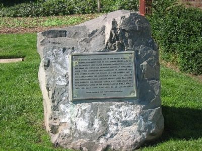
Here stood the lumberman’s village of Searsville whose first settler, John Sears, came in 1854. Across the road westerly from this monument stood a hotel. The school, store, blacksmith shop, and dwellings were to the southeast. Some on the site of . . . — — Map (db m10711) HM
In 1876, a visiting sailor presented the seedling of this Moreton Bay Fig Tree to a little girl who planted it at 201 State Street. When the girl moved away a year later, her friend Adeline Crabb relocated the sapling to the location before you. . . . — — Map (db m115203) HM
This famous tavern and stage stop was located 21 miles from San Jose on the road to Monterey. The 21-Mile House was built in 1852 by William Host beneath a spreading oak that later was called the Vasquez Tree. The house was sold to William Tennant . . . — — Map (db m156621) HM
Under this Giant Redwood, the Palo Alto, November 6 to 11, 1769, camped Portola and his band on the expedition that discovered San Francisco Bay. This was the assembling point for their reconnoitering parties. Here in 1774 Padre Palou erected a . . . — — Map (db m41255) HM
New Almaden Quicksilver Mine has been designated an historical landmark by American Society for Metals. Discovered in November 1845, it was the first workable quicksilver mine in North America and preceded the Coloma Gold Discovery of January 1848 . . . — — Map (db m15055) HM
Here, along Arroyo de los Alamitos Creek in 1824, Luís Cabolla and Antonio Suñol first worked New Almaden ore in an arrastra. In constant production since 1845, more than a million flasks of quicksilver valued at over 50 million dollars have been . . . — — Map (db m18692) HM
Directly opposite this tablet was located the first State Capitol Building in which California’s first legislature assembled in December 1849. San Jose was the seat of government from 1849 to 1851. — — Map (db m3615) HM
This building, designed by George W. Page in 1891, became the permanent home of a congregation that first met in City Hall in 1866. A version of Richardsonian Romanesque style, the innovative structure withstood the earthquake of 1906 and became a . . . — — Map (db m30126) HM
Constructed in 1892 this was the first federal building in San José. It served as U.S. post office from 1892 to 1933. Designed by Willoughby Edbrooke and constructed of locally quarried sandstone, this Romanesque style structure, built by the United . . . — — Map (db m3611) HM
Jay Orley and Everis A. Hayes built this Mission Revival Style mansion, designed by George W. Page in 1904. The Hayes Brothers were early San Jose Mercury publishers, prominent valley politicians, and were actively involved in establishing the . . . — — Map (db m18496) HM
Three-quarters of a mile northeast is Montgomery Hill, site of the 55 successful flights of the “aeroplane” of John Joseph Montgomery which demonstrated aerodynamic developments still indispensable to modern aircraft. Here the basic principles of . . . — — Map (db m7127) HM
San Jose's Electric Light Tower was the inspiration of JJ. Owens, editor of the San Jose Mercury. On May 13, 1881, Owens printed an editorial suggesting that by providing one high and immense source of arc light, the night would become as day . . . — — Map (db m52140) HM
Oldest known rural school district in California. Established 1851 as subscription school, meeting in private homes. First teacher, Charles Lafollette, 1851, term three months. Abraham H. Featherman, 1852, term six months. Through efforts of Samuel . . . — — Map (db m2622) HM
Here, on January 8, 1847, Francisco Sanchez, leader of a California band surrendered himself and some American prisoners and arms to Lieut. Grayson thus ending the “Battle of Santa Clara” or the “Battle of the Mustard Stalks” of January 2, 1847. . . . — — Map (db m2627) HM
Anza exploring party passed through the Saratoga area March 25, 1776. Lumbering in the mountains, which began 1847 and continued many years, brought the first settlers 1850. Among other industries established were lime quarry 1850s, grist mill . . . — — Map (db m2624) HM
Built in 1892-93 and believed to be the tallest covered bridge in the country, it stood as the only entry to Felton for 45 years. In 1937 it was retired from active service to become a pedestrian bridge and figured prominently in many films of that . . . — — Map (db m2348) HM
Here in 1850 "Doc" Baker established a stopping place for emigrants on what became known as the Nobles Trail. George and Anna Marie Dersch bought out Baker and homesteaded the land in 1861. Tenants of the Dersches were responsible for whipping three . . . — — Map (db m57822) HM
Burney Falls
has been dedicated a
National Natural Landmark.
This site possesses exceptional value as an illustration of the nation's natural heritage and contributes to a better understanding of man's environment. — — Map (db m546) HM
Established by Samuel Lockhart in 1856 as a link in the first wagon road from Yreka to Red Bluff, the Lockhart Ferry crossed below the confluence of the Fall and Pitt Rivers near this spot. After a massacre in December 1856, the ferry was . . . — — Map (db m10292) HM
In 1868, near this spot, the first school in Fall River Valley was built. The building was of log construction, 20 feet by 30 feet, with no floor or windows. About 1870 the first sawmill in the valley was built at Dana where lumber was obtained to . . . — — Map (db m57827) HM
This stone monument, built in 1935, stands at the historic north entrance to Lassen Volcanic National Park from Lassen National Forest. Before the highway intersection was rerouted to its current location, visitors drove past this monument into the . . . — — Map (db m58126) HM
Major Pierson Barton Reading, California explorer and participant in the Bear Flag Revolt, discovered gold on this bar in 1848. Soon afterwards he made a similar find on the Trinity River. News of these discoveries opened the entire northern region . . . — — Map (db m57817) HM
Has Been Designated a
Registered National
Historic Landmark
Under the Provisions of the Historic Sites Act of August 21, 1935
This Site Possesses Exceptional Value
in Commemorating and Illustrating
the History of the Unites . . . — — Map (db m100345) HM
Erected in 1852, this historic building was ostensibly intended for Benicia City Hall, offered as the State Capitol and promptly accepted, it had that honor from February 4, 1853 to February 25, 1854. Deeded to state in 1951, it was one of the four . . . — — Map (db m16375) HM
[Marker mounted on front of base (Photo #1]
The birthplace of Mills College, founded in 1852 as the Young Ladies' Seminary of Benicia. Acquired from Mary Atkins by Cyrus and Susan Mills in 1865. It was moved to its present site in Oakland . . . — — Map (db m16312) HM
In 1882, Mathew Turner of San Francisco relocated his shipyard to Benicia. Turner, the most prodigious shipbuilder in North America, constructed 228 vessels, 169 of which were launched here. In 1913, the shipyard was purchased by James Robertson, . . . — — Map (db m31007) HM
Erected by pioneers of Methodist Episcopal Church South with volunteer labor and donated funds. Cornerstone laid October 3, 1856. Dedicated February 1857. Site supplied by Landy and Sandy Alford. Chapel deteriorated by 1929 and deeded by the church . . . — — Map (db m16294) HM
Gould-Shaw House
Thomas Jefferson Gould, an Indiana born blacksmith, built this house, which has become an important part of the town’s history, in 1862. One of the few surviving examples of Gothic Revival architecture, the house is the oldest . . . — — Map (db m109979) HM
Cotati's hexagonal town plan, one of only two such in the United States, was designed during the 1890s by Newton Smyth as an alternative to the traditional grid land planning. The six-sided town plaza was designed for founder Thomas Page, and each . . . — — Map (db m11998) HM
In early 1905 through the efforts of General Wagner, this Civil War Era cannon was delivered to Glen Ellen where it was placed in the center of town. It has continuously been recognized as the town marker and as a symbol of community for the town. . . . — — Map (db m24961) HM
This structure served the important hop industry of California’s North Coast Region, once the major hop-growing area in the west. Built in 1905 by a crew of Italian stonemasons, it represents the finest existing example of its type, consisting of . . . — — Map (db m10352) HM
To the east, at the top of the ridge, sits the landmark “Dos Piedras”, erroneously translated into “two rock”, between which ran the main Indian trail from Bodega Bay to the inland valley and to the Sierra. The rocks also . . . — — Map (db m64810) HM
County Landmarks Commission
County of Sonoma
Harazthy Villa (sic)
Historic Landmark
No. 19
This is to certify that the above historic site has been officially designated as a County Landmark by the Sonoma County Board of . . . — — Map (db m102579) HM
Picturesque mining center and trading post, 1849, once called Dentville. Early ferry to the southern mines; county seat 1862-72; rare wooden covered bridge reputedly designed by U. S. Grant, brother-in-law of the Dent brothers, 1854; old flour mill, . . . — — Map (db m178066) HM
Tehama County's board of supervisors and other county officials first met in rented rooms in the Union Hotel, later called Heider House. The county seat remained here from May 1856 to March 1857, when it was moved to Red Bluff. The Heider House was . . . — — Map (db m110474) HM
A reservation was originally established in 1857. Indians from a widespread area were brought here. The natives of this vicinity were the Kuyeti Tribe toward the west and the Yaudanchi Tribe toward the east. Both were branches of the Yokuts Indians . . . — — Map (db m13237) HM
Here Peter Goodhue operated am emigrant trail stopping place on the banks of the Tule River from 1854 to until the river changed its course in 1862. This became a Butterfield Overland Mail Stage Station, 1858-61. It was kept in 1860 by R. Porter . . . — — Map (db m10461) HM
Sizable settlement established at this rich placer location in 1849 by miners spreading east from Big Oak Flat and Groveland. Famous Hangman's Tree, part of which still stands (1950), reported to have been instrumental in death of a number of . . . — — Map (db m163766) HM
In 1846 General John C. Fremont passed this site of the sycamore tree on his way to sign a treaty with General Andres Pico to secure California for future annexation to the United States. It served the Padres as a resting place; the community as a . . . — — Map (db m114949) HM
The Heritage Oak that stood on this site for more than 400 years was witness to the 4 historical periods of Simi Valley. From the Chumash Indians, to the largest land grant ever made to the Pico family in the Spanish period, through the pioneer . . . — — Map (db m132651) HM
Founded in the town of Washington (Broderick), Yolo County by Hapgood, Hume, and Company in 1864, California’s first salmon cannery was located on a barge moored here on the banks of the Sacramento River. This small canning operation was the . . . — — Map (db m17520) HM
The Gable Mansion is an outstanding example of 19th Century Victorian Italianate architecture, one of the last of its style, size, and proportion in California. This structure was built in 1885 for Amos and Harvey Gable, pioneer Yolo County . . . — — Map (db m57627) HM
The first opera house to serve the Sacramento Valley was built on this site in 1885. The present structure, built in 1895-96, continues to represent an important center for theatrical arts of that period. Erected by David N. Hershey and . . . — — Map (db m11726) HM
This sign marks the site of The Holiday Drive-In, which operated from 1953 until 1988. Drive-In theaters were popular in the 1950s and 1960s, especially among young families and amorous couples, where films could be viewed from the relative . . . — — Map (db m18299) HM
The town of Georgetown built this small stone jail in the summer of 1883, using steel cells donated by the county. Built at a cost of $700, the stone jail was known for awhile as the "Hotel de Barr," after town Marshall Barr and for the "vertical . . . — — Map (db m39338) HM
Charlie Tayler used this waterwheel to power a stamp mill at his gold mining operations on Ute Creek. Tayler, who attributed his good health to the fact that he never kissed woman or took baths, built the waterwheel in 1893. It was moved to its . . . — — Map (db m74371) HM
This ancient tree was once part of a grove of native cottonwoods under which the local Ute Indians would camp and hold council prior to 1881. An Indian trail passed nearby. It has been identified as the Ute Council Tree since 1930, when the local . . . — — Map (db m119897) HM
18th St. Atrium
1919
One of the last buildings constructed in "Warehouse Row," which stretched from Cherry Creek to the 1900 blocks of Wynkoop Street, 1621 18th Street originated as the warehouse and offices for Bourk, . . . — — Map (db m97346) HM
Blake Street was named after Charles Blake, who came to Denver in 1858, and established supply depots throughout Lower Downtown.
Originally, the area was Denver's warehouse, brothel, and sporting house district. Some of the most infamous . . . — — Map (db m97357) HM
This property has been
placed on the
National Register
of Historic Places
By the United States
Department of the Interior
Secondary plaque
This property
has been designated as a
Historic . . . — — Map (db m105505) HM
This property has been
placed on the
National Register
of Historic Places
by the United States
Department of the Interior
Second plaque
This property
has been designated as a
Historic . . . — — Map (db m120800) HM
This mountain, 14,110 feet above the sea and the most celebrated peak in America, is named for the explorer, Capt. Zubulon M. Pike, who saw it first in 1806. He attempted to climb it, failed and reported it unclimbable. Ascended in 1820 by Dr. . . . — — Map (db m4846) HM
In 1910, newlyweds James and Victoria Newcomb bought this property from George Parker for $150. In January of 1911 they built their first home, which is the central portion of the present house. Reputedly, it was built quickly, "up and all closed . . . — — Map (db m97972) HM
Take Your Time and Enjoy Your Trip: Allow at least two hours to make the 38-mile round-trip to the summit and back. Uphill traffic has the right-of-way at all times. Watch for maintenance equipment.
Driving Up: If your engine begins . . . — — Map (db m45932)
In 1879, General William Jackson Palmer, the founder of Colorado Springs, convinced his friend, Charles Elliot Perkins to purchase land in Garden of the Gods. Perkins eventually bought a total of 480 spectacular acres surrounding the Gateway Rocks, . . . — — Map (db m135547) HM
Given to
the City of Colorado Springs
in 1909
by the children
of
Charles Elliott Perkins
In fulfilment of his wish
that it be kept forever
free to the public — — Map (db m135023) HM
This rock formation, called Sentinel Rock, is a geologic treasure. It is composed of two types of rock - a fine sandstone and a gravelly conglomerate. The various layers in this rock were deposited 275 million years ago. During that time, ancient . . . — — Map (db m135022) HM
Welcome to the south rim of the Black Canyon. The view here at Tomichi Point is just a sample of the spectacular scenery that is ahead. There are eleven more viewpoints between here and the end of the road at High Point, six miles away. Some of the . . . — — Map (db m92693)
The Golden Alarm Bell was purchased in 1904 by the original Loveland Hose Company of Golden from the C.S. Bell & Company, Hillsboro, Ohio. The bell was mounted on a tower at the corner of 9th and East Streets, the present home of the American Legion . . . — — Map (db m50594) HM
Windy Saddle Park
Jefferson County Open Space
Windy Saddle Park offers sweeping scenic views and trail connections to adjoining areas. Recreation opportunities on Chimney Gulch Trail and Lookout Mountain Trail included hiking, biking and . . . — — Map (db m46158) HM
Origins of the Park System
•These foothills west of Denver have long been a popular destination. In 1890 landscape architect Frederic Law Olmsted, who designed New York’s Central Park, was hired by local developers to design a resort in this . . . — — Map (db m46568) HM
Surrounded by deep canyons, villages here seem isolated, cut off from people on other mesas. Look closely at these cliffs and imagine hand and toe trails pecked into the sheer sandstone. These vertical trails were the Anasazi’s highways; steep . . . — — Map (db m71206) HM
Adapting to Alcoves To level the sloping alcove floor, the Anasazi filled in behind retaining walls. The altered floor not only supported rooms but also provided working space and a safe play area for children.
Oak Tree House appears to . . . — — Map (db m71209) HM
There is an enormous gap between identifying pithouse features—the hollows and scattered stones—and visualizing the inhabitants’ daily lives. Set in the four corner post holes, timbers supported a ceiling that was probably head-high. . . . — — Map (db m71203) HM
Mesa-top and Alcove Living Although the Puebloan used the cliff alcoves throughout the entire time they lived in Mesa Verde, the cliff dwellings themselves were not built until the final 75-100 years of occupation. For over 600 years these . . . — — Map (db m71207) HM
So read the article's headlines in the Lamar Daily News, September 27,1935. The Holland windmill built in the early 1930's in the backyard of the home of businessman Floyd M. Wilson on East Parmenter Street, Lamar, was featured as the garden's . . . — — Map (db m213849) HM
This property has been placed on the National Register of Historic Places
Summit County Courthouse
Cornerstone laid in 1909 on the "Most Beautiful spot in Summit County." Dedicated St. Patrick's Day, 1910.
This Corner Stone was . . . — — Map (db m57884) HM
This property has been placed on the National Register of Historic Places
The Wedding House
Built in 1893 by .
Frederick Herkert
for his bride. — — Map (db m57957) HM
1640 entries matched your criteria. Entries 201 through 300 are listed above. ⊲ Previous 100 — Next 100 ⊳