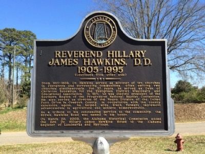
On Brown Hawkins Road at Fall Lane, on the left when traveling north on Brown Hawkins Road.
Side 1
Doctor Reverend Hillary James Hawkins, who was affectionately known throughout the community as “Brown,” dedicated most of his adult life to providing spiritual guidance to blacks in Evergreen and surrounding . . . — — Map (db m81292) HM
On County Road 85 at Hickory Tree Road, on the right when traveling north on County Road 85.
Born into poverty in Nymph, Conecuh County, on March 3,
1912. Moddie Daniel Taylor was the only child of Herbert
and Celeste (Oliver) Taylor. After the family relocated
to Missouri, Taylor attended Lincoln University,
graduating as . . . — — Map (db m283840) HM
On County Road 85 at Hickory Tree Road, on the right when traveling south on County Road 85.
Greater Nazarene is the oldest and largest African American Baptist
congregation in Conecuh County. The church was established in 1875 by
formerly enslaved people. They met in a building near the home of
Joseph Howard, who served as a deacon. . . . — — Map (db m283849) HM
On Nymph Road (County Route 85) at Hickory Tree Road, on the left when traveling south on Nymph Road.
Stephen Decatur Miller Jr., namesake of a former governor and U.S. Senator from South Carolina, moved to rural Conecuh County in 1850. He brought with him to this place at least thirteen enslaved people. Within a decade, farming interests enriched . . . — — Map (db m305848) HM
On County Road 85 at Hickory Tree Road, on the right when traveling north on County Road 85.
Born in Conecuh County on June 24, 1883, Maggie Taylor was a
daughter of Daniel and Millie (Moye) Taylor. Her parents were among
thirteen enslaved people brought to the rural community of Nymph
by their owner, Stephen D. Miller. With little . . . — — Map (db m283846) HM
On County Road 85 at Hickory Tree Road, on the right when traveling north on County Road 85.
Among the nearly four hundred graves in Nymph's Historic Nazarene
Cemetery are the unmarked resting places of enslaved men and women
brought to this rural Conecuh County community by their owner
Stephen D. Miller Jr. in 1850. These included . . . — — Map (db m283847) HM
On Alabama Route 22 west of Route 9, on the right when traveling west.
Peace & Goodwill Cemetery is Coosa County's first African American Cemetery to be placed on the prestigious Alabama Historic Cemetery Register. It provides powerful insights about the diligence and commitment of our African Ancestors. Family . . . — — Map (db m64587) HM
On Ridgeway Road 0.1 miles north of Mulberry Road, on the right when traveling north.
Residents of the Mulberry community
constructed the school in 1922 after
purchasing the property from John
Ridgeway and his wife, Georgie A.
Ridgeway. Community members donated their time, talents, and materials
to construct the schoolhouse. . . . — — Map (db m284069) HM
On East Main Street (Alabama Route 123) at Creel Richardson Street, on the right when traveling west on East Main Street.
Willie Mae "Big Mama" Thornton was born Dec. 11, 1926, in Ariton, Alabama,
the youngest of the seven children of Rev. George and Mattie Thornton.
She learned to play the harmonica at the age of eight. It is said that she
sat in front of the . . . — — Map (db m274311) HM
On Andrews Avenue, on the right when traveling south.
D. A. Smith High School
Dale County
The first school building on this site for African Americans was constructed in 1939 and was named Ozark Negro High School. It was replaced during the “separate but equal” period in 1952 and renamed to D. . . . — — Map (db m132087) HM
On Randolph Street 0.3 miles north of West Hwy 134 East ( Route 134), on the right when traveling north.
Front
The original part of this building was home to one of the oldest
African American schools in Dale County. In 1949 on this site, the
new building for the Pinckard Colored School was constructed and
Mack M. Matthews became its . . . — — Map (db m115029) HM
On Alabama Route 22, on the left when traveling east.
The Beloit Industrial Institute was founded in 1888 by Industrial Missionary Association, an area subdivision of the American Missionary Associations. The President of the Association, Dr. Charles B. Curtis, was a Presbyterian missionary and . . . — — Map (db m83504) HM
On Oak Street at Seven North Street, on the right when traveling north on Oak Street.
Three hundred feet ahead of you is the
entrance to one of Cahawba's oldest
cemeteries. On an 1883 map, it is
labeled "Negro burial ground." It also
appears, unlabeled, on the earliest Map
of the Town of Cahawba (circa 1819),
suggesting that . . . — — Map (db m274727) HM
On Vine Street, on the right when traveling north. Reported permanently removed.
The grassed over mound of brick before you was once Dallas County's courthouse. This courthouse was built in 1834. It was dismantled prior to 1905 by brick salvagers.
Cahawba was the county seat from 1818 to 1866. This brought a lot of people, . . . — — Map (db m23010) HM
On Oak Street (County Road 155), on the left when traveling north. Reported permanently removed.
In 1866, shortly after the Civil War and a severe flood, the county seat was moved from Cahaba to Selma. Residents rapidly abandoned the town. Many homes were dismantled and reassembled elsewhere.
Despite this trend, returning Confederate . . . — — Map (db m83516) HM
On Mulberry Street south of First South Street, on the left when traveling south.
These ruins were once a place of worship for members of the Methodist Episcopal Church South. Built in 1849, it was the first single denomination church in Cahawba. An earlier church for the common use of all denominations was erected about 1840. . . . — — Map (db m112410) HM
This house, the Fambro / Arthur home,
takes its name from two of its owners.
One was a judge, the other was a former
slave.
The Fambro Family
A. Judge W. W. Fambro built this house
in the early 1840s. He may have created . . . — — Map (db m112451) HM
On Business U.S. 80 north of Colby Avenue, on the right when traveling north.
Presented By
SCLC W.O.M.E.N. Inc., Women's Organizational Movement for
Equality Now
Southern Christian Leadership Conference
The Voting Rights Bridge Crossing/Selma to Montgomery
March/Jubilee Foundation and others,
Dr. Joseph E. . . . — — Map (db m224569) HM
On Martin Luther King Jr. Street at J L Chestnut Boulevard, on the right when traveling south on Martin Luther King Jr. Street.
For centuries, Selma was a city where the rules of race
were enforced by humiliation and fear. But Selma gave
birth to one of the greatest grassroots campaigns in
history—the voting rights movement. The Selma to
Montgomery march was the . . . — — Map (db m112370) HM
On Broad Street (Business U.S. 80) at Water Avenue, on the right when traveling north on Broad Street.
'Bloody Sunday' Attack at Edmund Pettus Bridge
A voting registration campaign in 1965 turned tragic Feb. 17 when an Alabama state trooper fatally shot Jimmie Lee Jackson in Marion. It prompted a protest march from Selma to Montgomery that . . . — — Map (db m81944) HM
On Martin Luther King Street 0.1 miles south of Clark Avenue, on the right when traveling south.
Brown A.M.E. Chapel (in front of you) served as a safe haven for supporters during the voting rights campaign. Pastor P.H. Lewis and his congregation courageously broke the injunction prohibiting African Americans from holding mass meetings, making . . . — — Map (db m131995) HM
On Business U.S. 80 north of Colby Avenue, on the right when traveling north.
The bloodshed on this bridge
named to honor Klan Leader,
Edmund Pettus, must fuel our
resolve to secure the right to
vote in perpetuity. This park
was designed and donated by
Hank and Rose Sanders to
honor their parents, Rev. D.A.
and Ora . . . — — Map (db m224571) HM
On FD Reese Street south of Philpot Avenue, on the right when traveling north.
As president of the Dallas County Voters League. Dr. Reese wrote and signed the 1964 letter inviting Rev. Martin Luther King, Jr. and the Southern Christian Leadership Conference (SCLC) to Selma to join the struggle for civil rights. On March 7, . . . — — Map (db m297245) HM
On FD Reese Street south of Philpot Avenue, on the right when traveling north.
In 1922, Rev. Love Tolbert founded Ebenezer in a former dance hall on the corner of St. Phillips Street and Philpot Avenue in Selma. After Rev. Tolbert's brief tenure. Rev. Jerry McGinnis served as interim pastor until Rev. Abraham White was . . . — — Map (db m297248) HM
On Martin Luther King Jr. Street at JL Chestnut Jr Boulevard, on the left when traveling north on Martin Luther King Jr. Street.
First Baptist was the first church in Selma to open its doors to members of the Dallas County Voters League as well as to young activists from the Student Nonviolent Coordinating Committee. From 1963 to 1965, under the leadership of Reverend M.C. . . . — — Map (db m112366) HM
On Martin Luther King Jr. Street north of St. Johns Street, on the right when traveling north.
In 1952, the City of Selma accepted federal funds to build the George Washington Carver Homes Projects. The residences became “The Face of the Civil Rights Movement” to many in the 1960s because Dr. King, the Southern Christian Leadership Conference . . . — — Map (db m112354) HM
On Martin Luther King Jr. Street at Clark Avenue, on the left when traveling north on Martin Luther King Jr. Street.
The George Washington Carver neighborhood served as base camp for the votings rights movement during the tumultuous weeks of March 1965. These blocks of brick two-story homes—the city's first and largest federal housing project for blacks, built in . . . — — Map (db m112365) HM
On Business U.S. 80 north of Old Montgomery Highway, on the right when traveling north.
The Selma-Montgomery March
"Bloody Sunday", March 7, 1965
Mothers of the Civil Rights Movement
Before and Beyond the Bridge
Didn't Let Nothing Turn Them Around!
Presented by
The Evelyn Gibson Lowery . . . — — Map (db m111691) HM
On Martin Luther King Street north of Selma Avenue, on the right when traveling north.
The demonstration that led to the most important advance in civil rights for millions of Black Americans began here March 21, 1965. It was the 50-mile march from Selma to Montgomery, Alabama, the State Capital.
Defying threats of death, Dr. . . . — — Map (db m83578) HM
On Business U.S. 80 north of Old Montgomery Highway, on the right when traveling north.
Leader of
The Selma-Montgomery March
"Bloody Sunday", March 7, 1965
He Fed the Hungry
"Unbossed and Unbought"
1926-2000
Presented by
SCLC/W.O.M.E.N. Inc.
Women's Organizational Movement for Equality . . . — — Map (db m111689) HM
On Martin Luther King Jr. Street 0.1 miles north of St. Johns Street, on the right when traveling north.
At the age of 20, Lewis lost his sight in 1957 from Glaucoma. He learned the
language of braille, other independent living and vocational skills during his
attendance at the Alabama Institute for the Deaf and Blind in Talladega, Alabama. . . . — — Map (db m112363) HM
Lynching in America
Thousands of African Americans were victims of lynching and racial violence in the United States between the Civil War and World War II. The lynching of African Americans during this era was a form of racial terrorism used . . . — — Map (db m132071) HM
On Marie Foster Street at Philpot Avenue, on the right when traveling south on Marie Foster Street.
Prior to 1960. Northern Heights Presbyterian Church was known as Sylvan Street Presbyterian Church. which began in 1896 as a Sunday school mission sponsored by the First Presbyterian Church of Selma. The church formally organized in 1900. Rev. . . . — — Map (db m297251) HM
On Summerfield Road at 1st Avenue, on the right when traveling south on Summerfield Road.
This school was the city of Selma's first public high school for African-Americans. Completed in 1949, the school was named in honor of Richard Byron Hudson, a black educator who had served for 41 years as principal of Clark Elementary School, . . . — — Map (db m82741) HM
On Martin Luther King Jr. Street 0.1 miles north of St. Johns Street, on the left when traveling north.
The shooting of Jimmie Lee Jackson in nearby Marion, Alabama, transformed Brown Chapel from a sanctuary into a staging area for the Selma march, In a passionate sermon SCLC worker James Bevel suggested making a pilgrimage to the State Capitol to . . . — — Map (db m112364) HM
On Church Street at Arsenal Place, on the right when traveling south on Church Street.
Confederate Army Captain James White was ordered to relocate the old Federal Arsenal from Mt. Vernon, Alabama. By 1865 it consisted of 24 buildings and had over 500 workers including men, women, boys, girls, FMofC and slaves. It made or contracted . . . — — Map (db m82750) HM
On Water Avenue at Washington Street, on the right when traveling east on Water Avenue.
following the Battle of Selma, April 2, 1865. This occupation protected the hotel from the arson and looting in the first 24 hours that destroyed much of downtown. In the next week Wilson methodically burned the huge military/industrial complex that . . . — — Map (db m80792) HM
On Broad Street (Business U.S. 80) at Minter Avenue, on the right when traveling south on Broad Street.
In January 1885, Dr. Edward M. Brawley, President, Alabama Baptist Normal and Theological School (now Selma University) formed Tabernacle Baptist Church to be an integral part of the students' Christian formation and education. Significant . . . — — Map (db m82034) HM
On Broad Street (Business U.S. 80) at Minter Avenue, on the right when traveling south on Broad Street.
Tabernacle Baptist Church was founded in 1885, and in March of that year, the congregation purchased this site. Built in 1922 under the leadership of Dr. David Vivian Jemison, the current church features bricks from the original church building . . . — — Map (db m83677) HM
On Franklin Street at Keller Avenue, on the right when traveling south on Franklin Street.
Ernest Leon Doyle was born in 1918. He and Ruth Lee Willis were married
in 1942. Ernest worked as a carpenter, decorator, and insurance agent.
Ruth was a teacher and supplemented the family income as a beautician.
The couple had three . . . — — Map (db m308041) HM
On Business U.S. 80 north of Old Montgomery Highway, on the right when traveling north.
Honoring:
Leader of
The Selma-Montgomery March
"Bloody Sunday", March 7, 1965
"Get in the Way"
"When We Pray, We Move Our Feet"
Presented by:
The Evelyn Gibson Lowery . . . — — Map (db m111683) HM
On Broad Street (U.S. 80) at Water Avenue, on the right when traveling north on Broad Street. Reported permanently removed.
(The Beginning)
The major civil rights protest, which focused national attention on the issue of racial discrimination in voting & led to the passage of the Voting Rights Act of 1965, was centered in Selma.
In January of 1963 local . . . — — Map (db m37662) HM
On Martin Luther King Jr. Street at J L Chestnut Boulevard, on the left when traveling north on Martin Luther King Jr. Street.
By early 1964, the Dallas County Voters League (DCVL) and Student Nonviolent Coordinating Committee's (SNCC) efforts to organize for voting rights had reached a turning point. In July 1964 Judge James Hare, pressured by Selma law enforcement to . . . — — Map (db m112369) HM
On Summerfield Road at Highland Avenue (U.S. 80), on the right when traveling south on Summerfield Road. Reported missing.
The Lightening Brigade of the 2nd Division would spearhead the attack between Redoubts No. 13 - No. 16. Artillery covered all the approaches. At 5 p.m. General Long ordered the Second Division forward. "As Long's Second Division charged . . . — — Map (db m83682) HM
On State Highway 22 at County Road 65, on the right when traveling south on State Highway 22.
Established in 1816 by eight families from Rocky River Presbyterian Church in Mecklenburg County, North Carolina.
In 1859 this two-story brick building replaced original wooden structure.
Sanctuary and former slave gallery are on second . . . — — Map (db m83683) HM
On Lancaster Street 0.1 miles north of Holtville Road ( Route 111), on the right when traveling north.
Constructed in 1924 on five acres, this building was one of nine schools constructed in Elmore County with funding assistance from the Julius Rosenwald Fund. Between 1912-32, Julius Rosenwald, a Jewish philanthropist and CEO of Sears, Roebuck and . . . — — Map (db m70548) HM
On South Pine Street at Ouiwatumpkis Street, on the left when traveling south on South Pine Street.
Born in Wetumpka in 1950 and raised in the Level community, Ronnie
Lovejoy Sr. became a celebrated Soul and Blues singer-songwriter in the late
twentieth century. Lovejoy's musical influences began with his family.
His mother, Golaties White . . . — — Map (db m286050) HM
On Mathis Road west of Marshell Road, on the left when traveling west.
The New Prospect Baptist
Church, Wetumpka has been
designated as a significant
African American historic
site by the Black Heritage
Council of the Alabama
Historical Commission. — — Map (db m245698) HM
On Micanopy Street 0.1 miles west of NW Main Street, on the right when traveling west.
W. B. Doby served as the first President of the Elmore County Teachers Association, Principal of Elmore County Training School, and as an ordained minister in the A.M.E. Church. Local leaders dedicated this school for African-American students on . . . — — Map (db m94614) HM
On Orline Street 0.1 miles south of Hill Street, on the right when traveling south.
In 1834, the Wetumpka Toll Bridge Co. built the first of four bridges spanning the Coosa River at this site. It was destroyed in a flood in 1844. A second toll bridge was completed the same year by John Godwin whose slave, Horace King, designed . . . — — Map (db m69449) HM
On Martin Luther King Avenue north of McGlasker Street, on the right when traveling north.
In 1920, a wooden building was constructed as the Atmore Colored School and operated until 1925. In 1926, a new wood and a brick building was erected with assistance from Rosenwald School fund and it was renamed the Escambia County Training School. . . . — — Map (db m100835) HM
On North 1st Street at Locust Street, on the right when traveling north on North 1st Street.
Lynching in America.
Thousands of Black people were the victims of lynching and racial violence in the United States between 1877 and 1950. The lynching of African Americans during this era was a form of racial terrorism intended to intimidate . . . — — Map (db m116817) HM
Near South Sixth Street 0.2 miles south of Oak Street.
Established in 1826 as "The Colored Cemetery," this site is
the first and largest African-American cemetery in Gadsden.
In 1918, the Mosaic Templars of America, a fraternal
organization who provided African Americans with death and
burial . . . — — Map (db m167227) HM
On Rainbow Drive (U.S. 411) at Cemetery Road, on the right when traveling east on Rainbow Drive.
Oldest church in Etowah County. Organized Saturday, April 2, 1831, at Harmony Meeting
House, which was built in 1821, by Edmond Jones at this location.
It was here that the Wills Creek Baptist Association was organized in 1836, Harmony
being . . . — — Map (db m205239) HM
On County Road 12 2.2 miles east of State Highway 171, on the left when traveling west.
Freeman Lake is named for Joseph Freeman (1919-2005), a
community leader and activist who saw a need in Newtonville,
Fayette County, and surrounding communities for a place
for recreational activities in the segregated south. The
lake was a . . . — — Map (db m289191) HM
Near County Road 100 0.3 miles east of Center Road, on the right when traveling west.
Founded in 1889 by Mathew Freeman, who was born into slavery in 1854 and died in 1930. Shady Grove Missionary Baptist Church and Cemetery played an important role in Newtonville, Fayette County, and surrounding communities. He was a trailblazer and . . . — — Map (db m289192) HM
On Hamilton Street east of Mullins Avenue, on the right when traveling west.
Reedtown High School is significant as the oldest remaining black
school and first black high school in Russellville. Although this
building opened in 1952. Reedtown School began 30 years earlier
as one of two Rosenwald Schools built in . . . — — Map (db m286458) HM
On County Line Drive east of Kelly Street, on the left when traveling south.
In November 1882, five charter members -- Adline Adams, Jane And Alexander Johnson, Hariett and Robert Wadsworth -- organized Countyline Missionary Baptist Church on land donated by Shade Adams, They named it for the Mother Church, Countyline, of . . . — — Map (db m199422) HM
Near County Line Drive east of Kelly Street when traveling south.
The Countyline Missionary Baptist Church and adjoining cemetery were established in November 1882, on land donated by Shade Adams, Originally donated by way of a gentleman's agreement with the founding members, the land was deeded to the 'Countyline . . . — — Map (db m199425) HM
On Tuscaloosa Street (Alabama Route 14) east of Springfield Avenue, on the right when traveling east.
On this site, in January 1971, Thomas Earl Gilmore, Sr. was sworn in as Sheriff of Greene County. He was the first African American Sheriff in the county's history and served three consecutive terms until he retired from local politics.
Gilmore, . . . — — Map (db m203630) HM
Near County Road 156 east of Zion Hill Church Road, on the right when traveling east.
Zion Hill Missionary Baptist Church erected a church structure in 1879 on land owned by James Allen Peebles, who then donated the property to the church. Scottish-born brothers Albert and Lemuel Peebles were free Black people who immigrated to . . . — — Map (db m297061) HM
On U.S. 80 2 miles east of State Highway 69, on the right when traveling east.
In 1867 a group of African American men and women laid the foundations for Freetown. William, John, Albert, George, Richard, and Peter Collins; Susan and Lawrence Moore; Thomas Jeffries; the children of John Jeffries; and Louisa Conway and her . . . — — Map (db m38192) HM
On Oak Grove Road 0.1 miles west of Route 69, on the right when traveling west.
Tuskegee educator Booker T. Washington and Julius Rosenwald, Sears, Roebuck & Company president, initiated one of the most ambitiuous school building programs for African Americans in the United States. The Oak Grove School is one example of the . . . — — Map (db m83753) HM
On Main Street at Demopolis Street, on the right when traveling east on Main Street.
Organized 1823 by Rev. James Hillhouse
of South Carolina, with
Patrick Norris and William Hillhouse,
veterans of American Revolution,
as founding elders.
Original wooden structure replaced
by brick building in 1841
under pastorate . . . — — Map (db m33746) HM
On County Road 25 at County Road 225, on the right when traveling south on County Road 25.
Founded by Laura L. Ward. Building designed and constructed by Jim McCauley on land given by Glass Maybin. Classes began Sept., 1917. Principals who served school were: J. H. Jackson, W. R. Rosser, Felix Blackwood, Sr., and William B. Ward, Sr. . . . — — Map (db m71809) HM
On Alabama 10 (Alabama Route 10) 1.3 miles west of U.S. 431, on the right when traveling west.
Civil rights pioneer Rosa McCauley Parks was born on February 4, 1913 in Tuskegee, Alabama. Shortly after her birth her parents James and Leona McCauley, moved here to a 260 acre farm owned by her grandparents, Anderson and Louisa McCauley. Her . . . — — Map (db m241312) HM
On County Road 40 east of County Road 220, on the right when traveling west.
Green Valley Missionary Baptist Church is among the oldest active churches in Henry County. It was established in 1865 by freedmen of the surrounding community as a combination church and school. The first edifice was a small log structure built on . . . — — Map (db m257407) HM
On North Broad Street (Alabama Route 173) 0.1 miles south of North Railroad Street (County Road 7), on the left when traveling south.
Newville High School
The first known school in Newville was at Center Church in 1881. When Grange Hall was built in 1891, church services and school were held on the first floor. In 1913, Grange Hall was torn down and the wood was used to . . . — — Map (db m71812) HM
On North Cherry Street at East Adams Street, on the right when traveling north on North Cherry Street.
On this site in 1877 Gaines Chapel Church was organized. A wooden structure was erected adjacent to an existing graveyard. In 1891 and 1901 additional land was purchased.
In 1908 the present building was dedicated. This structure was of early . . . — — Map (db m73362) HM
On John T Reid Parkway (U.S. 72) at Church Street, on the right when traveling south on John T Reid Parkway.
(side 1)
The History of Paint Rock, Alabama
Originally Camden circa 1830, the post office was renamed Redman in 1846 and became Paint Rock on May 17, 1860. After the Memphis and Charleston Railroad Co. built a depot and water . . . — — Map (db m69756) HM
Near Cedar Hill Drive at West Appletree Street, on the right when traveling south.
In November 1868, after the official records of Jackson County were relocated from Bellefonte to the new seat of government in Scottsboro, a campaign was begun for a new municipal cemetery here. Around 1876, Charlotte Scott Skelton. daughter of . . . — — Map (db m290807) HM
On E Peachtree Street, on the right when traveling west.
Marker front:
Constructed in 1911-1912 and designed by architect Richard H. Hunt, the Jackson County Courthouse is a Neo-Classical, brick building situated on a town square in Scottsboro, the county seat of Jackson County. The front, . . . — — Map (db m22264) HM
The Memphis and Charleston Railroad Company constructed the Scottsboro Railroad Depot in 1860-1861 as a passenger and freight facility. The rail line ran throughout the Confederacy and the Union considered its capture vital to cutting off supplies . . . — — Map (db m22258) HM
On Old Mount Carmel Road (County Route 85) at Ohio Avenue, on the left when traveling west on Old Mount Carmel Road.
During the Reconstruction Period following the Civil War, a freedmen’s community was established in this area called Averyville, named for the Pennsylvania minister and successful businessman Charles Avery, a longtime and faithful champion of Negro . . . — — Map (db m108803) HM
On Finley Avenue North 1 mile east of 13th Place North, on the right when traveling east.
In honor of Julius Ellsberry of Birmingham
World War II Hero
First Jefferson County Citizen
to die for his country at Pearl Harbor while serving aboard the U.S.S. Oklahoma December 7, 1941 — — Map (db m70261) HM
On Palm Sunday, 1963 Rev. N. H. Smith, Rev. John T. Porter and Rev. A. D. King led a sympathy march from St. Paul United Methodist Church down 6th Avenue North in support of Rev. Martin Luther King, Jr., Rev. Fred Shuttlesworth and Rev. Ralph . . . — — Map (db m73023) HM
On 5th Avenue North east of 15th Street North, on the right when traveling east.
Built 1959-60, 1517 5th Ave. N.
The A. G. Gaston Building's second floor conference room was
the location of regular meetings of “Project C's” Coordinating
Committee. Here, they planned strategies for the April - May
1963 marches, boycotts, . . . — — Map (db m187976) HM
On 20th Street North north of Park Place, on the right when traveling north.
In 1963, Birmingham underwent a major political transformation. To
force Commissioner “Bull” Connor from office, progressive Whites and
Blacks plotted to change the form of government from Commissioners
to a Mayor-Council system. Mayor Albert . . . — — Map (db m187705) HM
On 22nd Street North south of 7th Avenue North, on the right when traveling south.
Southern members of the U.S. Congress in 1956 issued the "Southern Manifesto” that called the U.S. Supreme Court's Brown decision an "abuse of judicial power." By forcing public school integration contrary to social custom,
the high court had . . . — — Map (db m187661) HM
On Reverend Abraham Woods Jr Boulevard at 19th Street North, on the right when traveling east on Reverend Abraham Woods Jr Boulevard.
Shuttlesworth began to dedicate himself to the ministry and enrolled
in Cedar Grove Bible College, a Baptist institution in the Mobile suburb
of Pritchard. He took classes at night while he worked during the day.
The young couple added two more . . . — — Map (db m187628) HM
On Park Place at 19th Street North, on the left when traveling east on Park Place.
Child protestors overwhelmed police, who found it hard to confine
them to the Kelly Ingram Park area. Organizers used clever methods
to get them to City Hall before police could stop them. Children were
sent out in pairs. When they got closer to . . . — — Map (db m187836) HM
On 19th Street North north of 7th Avenue North, on the right when traveling north.
Built 1947-50, 710 20th St. N.
Birmingham City Hall was the administrative center for the
enforcement of local segregation codes. Thus, this building was
one of the major destination points for the “Project C" marchers
in the 1963 . . . — — Map (db m187717) HM
On 20th Street North north of Park Place, on the right when traveling north.
Freddie Lee Robinson was born March 18, 1922, in Mt. Meigs,
Montgomery County, Alabama, to Alberta Robinson and Vetter Greene.
The unmarried couple also conceived a girl, Cleola. Because Vetter
could not provide for his growing family, Alberta's . . . — — Map (db m187631) HM
On Reverend Abraham Woods Junior Boulevard at 20th Street North, on the left when traveling east on Reverend Abraham Woods Junior Boulevard.
Built 1924 (Extended in 1957), 1930 8th Ave. N.
In 1924, Municipal Auditorium was one of the South's largest
(6,000 seats) and most modern auditoriums. In April of 1956,
Ku Klux Klansman Asa Carter led an attack on Montgomery
native and . . . — — Map (db m187715) HM
On 19th Street North at 2nd Avenue North, on the right when traveling north on 19th Street North.
Celebrities of all races - but particularly Black singers and actors such as
Harry Belafonte, Sammy Davis, Jr., Eartha Kitt, Lena Horne, and Ossie
Davis with wife Ruby Dee - played important roles in the Movement.
Some, including comedian Dick . . . — — Map (db m187822) HM
On 7th Avenue North at 22nd Street North, on the right when traveling west on 7th Avenue North.
Birmingham's Black schoolchildren played an important role in moving the
city toward ending legal segregation. Under the leadership of SCLC field coordinators, thousands of children left their segregated schools to join the
marches in the downtown . . . — — Map (db m187682) HM
On 19th Street North at 4th Avenue North, on the right when traveling north on 19th Street North.
On Mother's Day, May 14, 1961, a group of black and white CORE youth on a "Freedom Ride" from Washington, D.C. to New Orleans arrived by bus at the Birmingham Greyhound terminal. They were riding through the deep south to test a court case, "Boynton . . . — — Map (db m83809) HM
On 7th Avenue North at 23rd Street North, on the right when traveling west on 7th Avenue North.
Many African Americans continued to push for the right to an equal
education that the 1954 Brown decision gave them. Despite angry
threats of violence and intense economic pressure, those first few African American families in Birmingham who chose . . . — — Map (db m187693) HM
On 7th Avenue North west of 23rd Street North, on the right when traveling west.
Community civil rights leaders who helped organize the Movement and embraced the philosophy of nonviolence looked for well-disciplined children with good moral character who would at retaliate if they encountered bullying or violence by White . . . — — Map (db m187690) HM
On Park Place east of Richard Arrington Jr Boulevard North, on the left when traveling east.
Black leaders debated how best to educate their children to live in a racially segregated society. Former slave Booker T. Washington, founder
of Tuskegee Institute, was America's leading Black spokesman at the
turn of the 20th century and promoted . . . — — Map (db m187636) HM
On 19th Street North at 3rd Avenue North, on the left when traveling south on 19th Street North.
Built 1939, 1901 3rd Ave. N.
The F. W. Woolworth department store was one of the first sites targeted for the ACMHR and SCLC's economic boycotts and lunch counter sit-ins of “Project C” during the April - May 1963 mass demonstrations in . . . — — Map (db m188183) HM
Near Sloss Furnace Entry Road 0.3 miles east of 32nd Street North, on the right when traveling west.
Despite being dominated by black labor the industrial workplace was rigidly segregated
until the 1960's. Men punched separate time clocks and bathed in separate bath houses. Following the implementation of desegregation laws in the 1960's the black . . . — — Map (db m173370) HM
On 7th Avenue North at 23rd Street North, on the right when traveling west on 7th Avenue North. Reported damaged.
[Note: a portion of the wording on the first panel of the marker has been torn away.(See photo #1)]Paired marker
September 9, 1957
In 1957, Rev. Fred Shuttlesworth and his followers in
the Alabama Christian Movement for . . . — — Map (db m187702) HM
On Park Place at 22nd Street North, on the left when traveling east on Park Place.
The National Association for the Advancement of Colored People
(NAACP) used its Legal Defense and Educational Fund and its team of
skilled lawyers to attack the "separate but equal” education laws. Beginning in the 1930s, the NAACP filed lawsuits . . . — — Map (db m187658) HM
On 7th Avenue North west of 23rd Street North, on the right when traveling west.
As Birmingham's civil rights leaders pushed to desegregate city schools, radical opponents in Birmingham pushed back, sometimes violently. Responses against school integration included death threats by telephone to parents who dared send their . . . — — Map (db m187686) HM
On 19th Street North north of 2nd Avenue North, on the right when traveling north.
After White business leaders failed to remove segregation signs and
hire African Americans, by 1963 Birmingham Blacks felt betrayed by
broken promises. Many Whites wanted the change that Blacks
demanded to be gradual. Some Whites reasoned that . . . — — Map (db m187824) HM
Near Park Place east of 20th Street North, on the left when traveling east.
Built 1926-27, 701 Richard Arrington Jr. Blvd. N.
The Birmingham Public Library was the city's main branch for
57 years. It was one of several protest target sites during the
1963 Birmingham Campaign. Like the city parks, Birmingham's
most . . . — — Map (db m187712) HM
On Park Place east of Richard Arrington Jr Boulevard North, on the left when traveling east.
Immediately after the Civil War, Northern church groups funded by
sympathetic Whites rushed to the South to start elementary schools
and colleges to educate freed slaves. Soon afterward, Blacks took the
lead in educating their own children. . . . — — Map (db m187635) HM
17053 entries matched your criteria. Entries 101 through 200 are listed above. ⊲ Previous 100 — Next 100 ⊳