On Trails End Road west of North Palestine Road, on the right when traveling south.
"Soldiers Retreat," located here, was the home of Ferdinand Leigh and Magdaline Claiborne. F.L. Claiborne (1772-1815) moved to the Mississippi Territory from Virginia in 1807 and served as Brig. Gen. with the 1st Mississippi Volunteers during the . . . — — Map (db m105260) HM
On St. Catherine Street, 0.2 miles west of McCabe Street, on the left when traveling west.
The 1928 Natchez City Directory lists Italian immigrant Sam Anzalone as operating a grocery store at 158-160 St. Catherine Street where he sold gasoline for 21 cents a gallon. Many of the late- nineteenth-century Italian immigrants farmed and sold . . . — — Map (db m114509) HM
On Martin Luther King Street at St. Catherine Street & Jefferson Street, on the left when traveling north on Martin Luther King Street.
300 North Martin Luther King Street (above) is home to the city's oldest funeral business.Robert D. Mackel (below) opened Bluff City Undertaking in 1898 at the corner of Jefferson and North Rankin Streets. About 1911 he relocated the business to . . . — — Map (db m108600) HM
On South Canal Street south of D.A. Biglane Street, on the right when traveling south.
The Stietenroth House is the last remaining example of a
number of residential buildings that once lined the western side
of South Canal Street. In the late 1800s and early 1900s,
Natchez families and real estate developers constructed . . . — — Map (db m196178) HM
Near S. Broadway Street south of Main Street, on the right when traveling south.
The Richard Wright historic marker recognizes the city’s most famous 20th-century writer. Born in 1908 on a cotton plantation near Natchez, Wright spent his early childhood in town in the home of his grandparents at 20 East Woodlawn . . . — — Map (db m87176) HM
Near S. Broadway Street south of Main Street, on the right when traveling south.
When the Spanish laid out the town of Natchez about 1790, they set aside land on the bluff for use as a public park. In 1839, after the city had sold off most of the park and built Broadway Street, writer Joseph Holt Ingraham complained . . . — — Map (db m87177) HM
On North Broadway at Franklin Street, on the right when traveling south on North Broadway.
The Yazoo and Mississippi Valley
Railroad built the passenger station on
the bluff shortly after 1910, and the
Illinois Central Railroad was the last
railroad to own it. Like many smal
towns across America, Natchez lost
passenger . . . — — Map (db m118303) HM
Near N. Broadway Street north of Main Street, on the right when traveling south.
Bontura, built in 1851, was the home of Robert Smith, a free African American who ran the city’s most successful carriage business in the 1850s. The house stands at the head of Silver Street, which leads to Natchez Under-the-Hill. Smith . . . — — Map (db m87179) HM
On Lissie Street/Old Cotton Street, 0.2 miles north of Liberty Road, on the right when traveling north.
Mrs. Egbert Jones and Mrs. Ferriday Byrnes, members of the Mississippi State Society Daughters of the American Revolution (DAR), played important roles in the development of the Natchez Trace Parkway. Mrs. Jones, of Holly Springs, State Regent 1906 . . . — — Map (db m42629) HM
On St. Catherine Street near 6th Street, on the left when traveling west.
Henry Dumas poses on the front steps of 69 St. Catherine Street. Henry managed the Dumas Pharmacy at 707-09 Franklin Street, a building that also housed the medical practice and sanitarium of his brother Dr. Albert W. Dumas, Sr. In 1940 Dr. Dumas . . . — — Map (db m115637) HM
Near Orleans Street near South Canal Street (Business U.S. 84).
On bluff to south stood Ft. Rosalie, established by the French in 1716. Became nucleus of settlements from which the Miss. Territory was founded. Near this marker stood the French warehouse that was a center of bloodshed during the Natchez Massacre . . . — — Map (db m126870) HM
On South Canal Street near D A Biglane Street, on the right when traveling south.
In 1940, Natchez native Jefferson Davis Dickson built a
"reconstruction" of Fort Rosalie as a tourism attraction to
appeal to the city's early automobile-driving visitors. A World
War I flying ace and sports promoter, Dickson built several . . . — — Map (db m196846) HM
On D A Biglane Street at South Canal Street, on the right when traveling east on D A Biglane Street.
Occupied 1716-circa 1800 by successive French, British, Spanish and American garrisons during struggle for control of the Miss. River Valley. Nucleus of early settlements in the Natchez District.
Mississippi Department of Archives and . . . — — Map (db m126797) HM
On St. Catherine Street near Old D'Evereux Street, on the left when traveling west.
Louis and Anna Alexander resided in the craftsman style cottage (above) at 17 St. Catherine Street.Until his death in the late 1940s, Louis Alexander worked at the historic mansion Melrose for George and Ethel Kelly. He died during a trip to . . . — — Map (db m115953) HM
On Jeff Davis Boulevard east of South Temple Road, on the right when traveling east.
Of the six mounds identified on the early 18th-century maps of the Grand Village, three remain. Mound A is now eroding into St. Catherine Creek. Mound B is a pyramidal platform mound, roughly seven feet tall, built in four stages. Each stage served . . . — — Map (db m103758) HM
On St. Catherine Street west of Liberty Road, on the left when traveling west.
Pre-Civil War St. Catherine Street The road, for the first mile, after leaving town, passed through a charming country, seen at intervals, and between long lines of unpainted, wretched looking dwellings, occupied as 'groggeries' by free . . . — — Map (db m106918) HM
On St. Catherine Street near Abbott Street, on the right when traveling west.
The portion of St. Catherine Street that extends from the site of the Rhythm Night Club to D'Evereux Street was originally part of the property of the city's first public hospital (above).The hospital fronted St. Catherine and stood on a hill on . . . — — Map (db m108586) HM
On North Wall Street at High Street, on the left when traveling south on North Wall Street.
Joseph Neibert built Choctaw in 1836 as his mansion townhouse. Neibert was a cotton planter. In the 1830s he and his partner Peter Gemmel, operated the city's most successful building firm, which employed both white and enslaved . . . — — Map (db m104476) HM
On Main Street at Canal Street, on the left when traveling north on Main Street.
The Protection Steam Fire Company No. 3 built a grand firehouse in 1902 at the corner of Main and Canal streets (no longer standing). During the 1800s and early 1900s, volunteers provided fire protection in Natchez as in most American . . . — — Map (db m127086) HM
On Main Street at North Pearl Street, on the left when traveling west on Main Street.
The 1927 Eola Hotel is the tallest building in downtown Natchez. Named for Eola Levy, the daughter of developer Isadore Levy, it became a center for social activity for the city. Celebrities who visited the hotel in the mid-1900s . . . — — Map (db m114303) HM
On South Commerce Street at Main Street, on the left when traveling south on South Commerce Street.
The Natchez Institute, built in 1901,
replaced an 1845 school building. The
Natchez Institute was the first
public school in Mississippi to offer a
full course of free education for white
children. The first public school . . . — — Map (db m127142) HM
On South Union Street at Main Street, on the left when traveling north on South Union Street.
An 1890 view of Memorial Park shows the Confederate soldier monument draped for unveiling. Like many others across the south, it faces north towards the opposing army.The park's creation was part of the Lost Cause Movement that expressed . . . — — Map (db m104480) HM
On North Canal Street near Jefferson Street, on the left when traveling north.
On this hill, Andrew Ellicott raised the American flag in 1797. This act claimed the Natchez Territory for the United States and helped hasten the departure of the Spanish. A few years later, James Moore built a home on the site, known today as the . . . — — Map (db m114446) HM
On Franklin Street at North Pearl Street, on the left when traveling east on Franklin Street.
The dramatic looking Natchez Hotel (no longer standing) was built in 1891. Within a few years, parts of the building began to disappear in stages. The tent-like dome went first in a storm, and a 1926 fire destroyed most of the structure. . . . — — Map (db m127090) HM
On Franklin Street near North Union Street, on the left when traveling east.
In the 1800s, Franklin Street was
headquarters for plantation supply
houses, and the street was filled with
wagons. Main Street merchants offered
house wares and dry goods, and it
attracted more carriages. Many of the
downtown . . . — — Map (db m199493) HM
On South BroadwayStreet near Washington Street, on the right when traveling south.
Edelweiss is a Swiss Chalet-style building which dates to 1883. The house offered both a great view of the Mississippi River and a convenient location for the family of its first owner, Joseph O'Brien, a coal-dealer at Natchez . . . — — Map (db m108807) HM
On State Street west of South Canal Street, on the left when traveling west.
William Johnson, a freed person of color, was a barber, entrepreneur, and slave owner. He built this house in 1841 using materials salvaged after the 1840 tornado that damaged much of downtown. His diary details its construction and . . . — — Map (db m115610) HM
On South Pearl Street at State Street, on the right when traveling north on South Pearl Street.
Institute Hall was built in 1852-1853 as a public auditorium and a companion building to the Natchez Institute. The contractors were the Weldon Brothers, who used over 100 enslaved craftsmen and whose head draftsman was a slave named . . . — — Map (db m115628) HM
On State Street near South Wall Street, on the left when traveling west.
The domed Federal-style Adams County Courthouse appears in Audubon's 1822-1823 painted landscape of Natchez. Built in 1817, this courthouse is the oldest in Mississippi. It was remodeled in 1925. Actions at the courthouse impacted all of . . . — — Map (db m114502) HM
On South Commerce Street at Washington Street, on the right when traveling south on South Commerce Street.
The present Temple B'nai Israel, built in 1904, replaced an 1870s temple that burned (pictured above). Both reflect the success of Jewish merchants after the Civil War. Jews lived in Natchez as early as the late 1700s, but their numbers . . . — — Map (db m114299) HM
On South Martin Luther King Street at Washington Street, on the right when traveling west on South Martin Luther King Street.
An 1866 photograph shows that the porch on the house at 705 Washington Street (behind you) was a later addition. Those who built houses without porches often soon added them. Travel writer Joseph Holt Ingraham noted in 1835 that the area's hot . . . — — Map (db m115604) HM
On Washington Street at South Pearl Street, on the right when traveling east on Washington Street.
The two matching brick houses at the corner (behind you) date to 1901 and stand on the site of a brick chapel (no longer standing) built in 1849 by the First Presbyterian Church. The chapel held Wednesday evening prayer services, . . . — — Map (db m107249) HM
On Washington Street at South Rankin Street, on the right when traveling west on Washington Street.
Gathered on the front steps of Green Leaves are the founders of the Natchez Garden Club, the women who started the local historic house tours in 1932. The vision of these women created the city's heritage tourism industry, today a major . . . — — Map (db m115605) HM
On South Union Street near Washington Street, on the right when traveling south.
All four of the houses at this intersection were built before the Civil War, and three are associated with the family of Joseph Quegles, a Spaniard who settled in Natchez during the Spanish period (1779-1798).Four houses near the . . . — — Map (db m114301) HM
On Washington Street at South Wall Street, on the right when traveling west on Washington Street.
Known as the Spanish Quarter in the early 1800s, this neighborhood is one of the oldest in Natchez. Each corner house dates to before the Civil War.
A Spaniard, Manuel Texada, built the house called Texada . . . — — Map (db m127092) HM
On Hutchins Landing Road east of Brick Quarters River Road, on the right when traveling east.
Erected, 1968, by Descendants of the New Jersey Settlers Organization (formed 1940) in memory of settlers of 1772, including Captain Amos Ogden. The Swayzes, Thorns & others now rest in the Kingston Cemetery — — Map (db m103816) HM
On Hutchins Landing Road, 0.3 miles east of Hillside Plantation Road, on the left when traveling east.
Erected, 1968, by Descendants of the New Jersey Settlers Organization (formed 1940) in memory of settlers of 1772 & their descendants who rest in Caleb King & Daniel Farrar Cemetery, Kingston Plantation. — — Map (db m104044) HM
On St. Catherine Street at 6th Street, on the left when traveling west on St. Catherine Street.
John R. Lynch turned to writing in his later years and wrote the Facts of Reconstruction in 1913. He completed his autobiography Reminiscences of an Active Life when he was 90, two years before his death in 1939.Lynch invested . . . — — Map (db m115927) HM
On Hutchins Landing Road, 0.3 miles east of Hillside Plantation Road, on the right when traveling east.
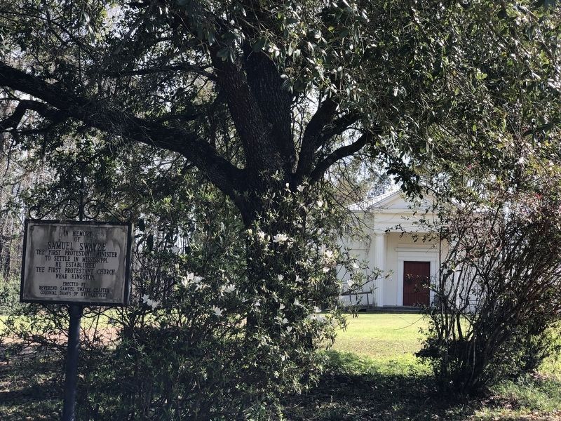
S.E. 1 mile is site of Old Jersey Settlement now known as Kingston. Here settlers from New Jersey organized first Protestant church in Mississippi with Samuel Swayze as pastor. — — Map (db m104043) HM
On U.S. 61 at Kingston Road, on the right when traveling north on U.S. 61.
E. 8 mi. Settled, 1773 by N. Jersey pioneers led by Richard and Samuel Swayze. Latter formed Congregational church, reputedly the first Protestant church in state. — — Map (db m120192) HM
On U.S. 61 at Kingston Road, on the right when traveling north on U.S. 61.
8.8 Miles to KINGSTON First Protestant Settlement In Mississippi Territory 1773.Dedicated 1955 by The National Society Of The Colonial Dames of America In The State Of Mississippi. — — Map (db m120264) HM
On S. Broadway St at Bontura Street, on the right when traveling south on S. Broadway St.
First settled by French, 1716-29. Lasting growth came with Britain, 1763-1779, and Spain, 1779-98. Cotton and trade made it commercial and cultural capital of Old South. — — Map (db m4479) HM
Near S. Canal Street, 0.2 miles north of John R. Judkin Drive (U.S. 84), on the left when traveling north.
Here passed, in 1543, De Soto’s men under Moscoso. In 1682 La Salle and De Tonti here visited the Natchez Indians. In 1716 Bienville here built Fort Rosalie and established a French settlement. In 1763 the fort was ceded to the English and renamed . . . — — Map (db m87167) HM
Near North Broadway Street near Jefferson Street, on the left when traveling north.
The Harper family mansion had a spectacular view of the river from the bluff. The construction of the railroad and related development made its land valuable for commerce, and the house and its garden were destroyed to build a large warehouse (no . . . — — Map (db m104673) HM
On Silver Street, 0.5 miles south of South Broadway Street, on the right when traveling south.
On May 8, 1840, one of the deadliest tornadoes in American history struck Natchez and killed about 300 people. Most of the dead were boatmen and passengers on steamboats docked at the waterfront. The city was already suffering from the economic . . . — — Map (db m143132) HM
On Silver Street, 0.5 miles south of South Broadway Street, on the right when traveling south.
For most of the 1800s, the prime mover of commerce and passengers on the Mississippi River was the steamboat, which was invented by Robert Fulton in 1807. The combination of the steamboat, the cotton gin, and improved strains of cotton . . . — — Map (db m143122) HM
On John R. Junkin Drive (U.S. 84) at Lower Woodville Road, on the right when traveling east on John R. Junkin Drive.
S. ½ mi. is grave of orator & statesman who came from Maine to Natchez in 1827 & won fame in law & politics, serving with distinction in legislature & in Congress. — — Map (db m103801) HM
On Silver Street east of South Broadway Street, on the right when traveling east.
The Spanish built Silver Street about 1790 to connect the town to the riverfront below. In the 1800s, Natchez Under-the-Hill was a major port on the Mississippi River. Natchez exported and imported agricultural goods, with cotton being . . . — — Map (db m127108) HM
On St. Catherine Street near McCabe Street, on the right when traveling west.
Ida McGuire Gillespie (left) and Odille Angelety grew up across the street from each other on St. Catherine Street and were lifelong friends. Odille never married and had a long distinguished career as a teacher at nearby Brumfield High School. An . . . — — Map (db m114291) HM
On S. Broadway St, on the right when traveling south.
Following acquisition of the Natchez District in 1779, the Spanish founded the City of Natchez ca.1790 to serve as the capital. Under Governor Manuel Gayoso, the city was planned and surveyed by John Girault in a typical Spanish grid plan around a . . . — — Map (db m10058) HM
On Morgantown Road at T Waring Bennett Jr. Road, on the left when traveling north on Morgantown Road.
On January 21, 1905, a number of families from struggling farming communities near Bologna, Italy, left Genoa bound for New York aboard the S.S. Montevideo. Many of these families ventured south, some settling in this area near St. . . . — — Map (db m105231) HM
On St. Catherine Street west of Auburn Street, on the left when traveling west.
John J. Nosser, Mayor of Natchez from 1962 to 1968, was born in Lebanon in 1899 and immigrated to the United States in 1919. Mississippi welcomed a number of Lebanese immigrants who became some of the most successful businessmen in their . . . — — Map (db m114458) HM
On St. Catherine Street near Fourth Street, on the left when traveling west.
Seamstress Laura Davis made the lavish dress and train worn by Cassell Carpenter when she was Pilgrimage Garden Club Queen in 1966. Carpenter posed in the parlor of her home Dunleith for local photographer Mabel Lane, the city's most popular . . . — — Map (db m115935) HM
On South Commerce Street at Washington Street, on the left when traveling south on South Commerce Street.
Jewish Americans have been part of Mississippi’s economic, social and political life since the 1780’s. In 1843, the Jewish community of Natchez grew large enough to organize and sustain the state’s first permanent religious congregation, Temple . . . — — Map (db m79345) HM
On St. Catherine Street west of 6th Street, on the left when traveling west.
The will of William Barland, a wealthy planter and downtown property owner, disclosed an interesting domestic relationship that has long intrigued historians. Proven in 1816, the will legally acknowledged Barland's relationship with "friend and . . . — — Map (db m115928) HM
On South Canal Street, 0.2 miles north of John R. Junkin Drive (U.S. 84/425), on the right when traveling south.
During the 1600s and 1700s, Spain, France and Great Britain established outposts for commerce, defense, and settlement in North America. French explorers sought to claim and control North America by using the Great Lakes and the . . . — — Map (db m137184) HM
On U.S. 61 south of Forest Plantation Road, on the right when traveling north.
Home and grave of William Dunbar (1749-1810), Scot settler who surveyed the boundary line between the USA and Spain-1798 and led 1st exploration of LA Purchase 1804. World-famed scientist and inventor in Miss. Territory. — — Map (db m103857) HM
On South Canal Street near Green Street, on the right when traveling south.
The French needed a strong defensive fortification in the lower Mississippi River valley to
prevent European intrusions from the south, and the bluffs overlooking the Mississippi
River at the settlement of the Natchez proved ideal. Following the . . . — — Map (db m137711) HM
On St. Catherine Street near Old D'Evereux Street, on the left when traveling east.
Pictured (left to right) are the Stallone sons, Hugo, Serviglio, Premo, and Meno. All of the sons worked on St. Catherine Street. Hugo operated a grocery store, where his brother Serviglio also worked. Premo opened a plumbing and electrical . . . — — Map (db m115624) HM
Photographer Earl Norman stood on Jefferson Street and snapped this view of the intersection of St. Catherine, Martin Luther King and Jefferson streets.A single column of the portico of Zion Chapel A.M.E. Church appears on the far right. Holy . . . — — Map (db m108599) HM
On Saint Catherine Street near O'Brien Street, on the right when traveling west.
Lettie Stanton, most likely born into slavery and possibly at Brandon Hall, had a stable relationship with cotton planter William Page, who never married anyone else and fathered her two daughters, heirs to the Page estate.Margaret Page, daughter of . . . — — Map (db m114292) HM
On Jefferson College Street north of U.S. 61, on the right when traveling north.
Scientist-historian (1803-51). Lived ¼ mi. S.E. Research on yellow fever brought first quarantine in Old S.W. at Natchez, 1844. Author of scholarly book on the discovery and settlement of Mississippi Valley. — — Map (db m105397) HM
Near Natchez Trace Parkway (at milepost 5.1), 3.3 miles south of U.S. 61.
The Natchez Trace was still active and Mississippi had just become a state when the Elizabeth Female Academy opened its doors in November of 1818. Much can be learned about the culture of early Mississippi here in the community of Washington. As the . . . — — Map (db m87232) HM
On Foster Mounds Road, 0.5 miles south of Steam Plant Road, on the right when traveling north.
Foster Mounds consists of two mounds located on either end of a large village or plaza. Mound A was built in four stages during the Plaquemine Period, sometime after AD 1400. Its original size and shape have been modified to accommodate the late . . . — — Map (db m105230) HM
On Jefferson College Street north of U.S. 61, on the right when traveling north.
N. 200 yd. Founded 1802. Mississippi's oldest school. Received the first charter to be conferred for any purpose by legislature of Mississippi Territory. — — Map (db m105790) HM
On U.S. 61 at Assembly Street, on the right when traveling south on U.S. 61.
Built ca. 1801 and operated as a tavern by
Charles De France and Richard Fletcher,
the two-story, wood frame building
that stood here housed Mississippi's
territorial legislature from at least 1808
to 1811. At the time, Washington was . . . — — Map (db m136948) HM
After independence, the United States faced a challenge. Many remote, frontier emigrants lived in the shadow of the French or Spanish empires in North America.
In the Old Southwest, the Jefferson Administration threw a communication lifeline to . . . — — Map (db m244203) HM
On Jefferson College Street north of U.S. 61, on the right when traveling north.
Territorial capital 1802-17. Statehood constitutional convention held here in 1817. Legislature met here until 1820. During its great days, it was known as the "Versailles" of the territory. — — Map (db m105353) HM
On Main Street (State Highway 145) at Fillmore Street (State Highway 145), in the median on Main Street.
Began 1854 as Cross City. Proximity to Tennessee River and the railroads made it of great strategic value during the Civil War. Battle of Corinth fought here, Oct. 3-4, 1862. — — Map (db m66533) HM
On N. Polk Street (State Highway 145) at Woodlawn Drive, on the right when traveling north on N. Polk Street.
Founded in 1879 by the Milton B. Henry family on land sold by the Chickasaws to the U.S. government in 1832. Henry purchased 160 acres in 1856. Robert Henry Young, an infant grandson of M.B. Henry, was the first person buried here. The Henry . . . — — Map (db m66591) HM
On Fillmore Street (State Highway 145) north of Bunch Street, on the right when traveling north.
Built in 1857 for Judge W.H. Kilpatrick. Used in Civil War as headquarters of General Leonidas Polk. Bought in 1866 by Mrs. Thomas Quincy Martin and occupied continuously by her descendants. — — Map (db m66557) HM
On N. Fillmore Street (State Highway 145) south of Gloster Street, on the right when traveling north.
Judge W.H. Kilpatrick of Corinth had Oak Home built in 1857 by Tom Chesney, a local house designer and builder. Mr. M.S. Miller, a civil engineer working in Corinth shortly before the war, made this sketch in 1860, the only known Civil War vintage . . . — — Map (db m66700) HM
On County Route 364 at County Route 356, on the right when traveling north on County Route 364.
E. 9 mi. Founded 1836 as seat of “Old” Tishomingo, including present Alcorn & Prentiss counties. Named for battle of San Jacinto. Courthouse dates from 1854. Lost county seat, 1870. Home of Sen. E.W. Carmack. — — Map (db m77399) HM
On Main Street (State Highway 2) at College Street (County Highway 512), on the right when traveling east on Main Street.
Settled in 1840 as New Hope. Name changed to Kossuth in 1853 to honor Hungarian patriot Louis Kossuth. Home of Col. M.P. Lowery, found of Blue Mountain College. A skirmish occurred here during the Civil War. Alcorn Agricultural High School was . . . — — Map (db m155411) HM
On State Highway 24/33 at East Howard Street (State Highway 48), on the left when traveling north on State Highway 24/33.
Began as Spanish relay post. Was known prior to 1824 as Elysian Fields, or Amite Courthouse. Chartered in 1880. After 1884, new town, springing up on railroad, gradually absorbed old site. — — Map (db m96426) HM
On State Highway 33 north of Church Street, on the left when traveling north.
Named Dayton in 1884 in honor of David Day who gave the R.R. right-of-way. In 1917, Foster Creek Lumber & Mfg. Co. mill & town of Stephenson est. here. In 1934, named for L.O. Crosby who bought the vast co. holdings. — — Map (db m96180) HM
On Captain Gloster Drive (State Highway 24) at State Highway 33, on the left when traveling east on Captain Gloster Drive.
On Mar. 11, 1884, Gloster City was chartered. Named for Capt. Arthur W. Gloster, R.R. engin. Located on watershed of Amite & Miss. Rivers. Elev. 435 Ft. On Apr. 6, 1935, a tornado hit the town killing 9 residents. — — Map (db m96030) HM
On Meadville Road, 0.2 miles north of Tynes Lane, on the left when traveling north.
Across the road is site of home built in 1836 by John H. Nunnery, early settler of Amite County. He had eight sons in Civil War, one in Sp.~Am. War. New Zion Baptist Church was organized here, Oct. 4, 1881. — — Map (db m137969) HM
On Main Street (State Highway 24) at Broad Street, on the right when traveling east on Main Street.
Founded 1809 and chartered 1828. Site of first Confederate monument in state, 1871. Here Gail Borden conducted condensed milk experiments. Dr. Tichenor's antiseptic was also originated here. — — Map (db m92616) HM
On Natchez Trace Parkway (at milepost 176.3), 0.1 miles south of County Road 3122, on the right when traveling north.
About half a mile northwesterly, Bethel, meaning “House of God” was opened in 1822 as one of thirteen Choctaw mission stations. Indians, slaves, and other men “labored hard during four weeks ... frequently till 10 o’clock at night, . . . — — Map (db m87479) HM
On West Washington Street (Business Mississippi Route 12) west of North Jackson Street, on the left when traveling west.
Founded 1833; named after Chateaubriand's Indian heroine. Buried in county are 1st senator, Gordon Boyd, and 1st representative, Wm. Dodd, who named the county seat after Thaddeus Kosciusko. — — Map (db m140800) HM
On East Washington Street at North Huntington Street, on the right when traveling west on East Washington Street.
"Redbud Springs" in Indian days. Later named for Polish-American patriot. Chartered, 1836. On Natchez Trace near geographical center of state. Trade activity gave it title, "Beehive of the Hills." — — Map (db m140798) HM
On Cotton Row at North Sharpe Avenue, in the median on Cotton Row.
Named for President Grover Cleveland. Founded along Jones Bayou and Yazoo and Mississippi Valley R.R. in 1886. Downtown historic area listed in National Register of Historic Places in 1999. — — Map (db m90069) HM
On East Main Street (State Highway 444) at East Park North (Old State Highway 61), on the right when traveling west on East Main Street.
First settled in early 1850's by Col. James Brown. Named for an early settler, Robert Duncan, and incorporated in 1890. Andrew Jackson Donelson, nephew of Pres. Jackson, owned a plantation near here. — — Map (db m154858) HM
On North Edwards Avenue at West Martin Luther King Jr. Drive, on the right when traveling north on North Edwards Avenue. Reported permanently removed.
Largest U.S. Negro town; settled July 12, 1887 by ex-slaves of Joe Davis, who conceived idea before Civil War: Isaiah T. Montgomery (member of 1890 state convention) & his cousin, Benjamin T. Green. — — Map (db m89761) HM
On North Edwards Avenue (State Highway 161) at West Martin Luther King, Jr. Drive, on the right when traveling north on North Edwards Avenue.
Former slaves Isaiah T. Montgomery and Benjamin T. Green founded Mound Bayou on July 12, 1887, as a cooperative, self-governed African American community. They purchased land from the Louisville, New Orleans, and Texas Railroad Company. Incorporated . . . — — Map (db m162022) HM
First settler in what is now Calhoun City. Born 1776. Left S. Carolina in 1817 for Alabama. Came to Mississippi in 1840. Pioneer, politician, patriot, planter. Died October 20, 1855. Buried on old homesite ½ mi. NW. — — Map (db m107543) HM
Near Natchez Trace Parkway (at milepost 232.4), 2.6 miles north of Mississippi Highway 8, on the right when traveling north.
(Marker #1)
Prehistoric Trade
Raw materials and articles from distant areas reached the Indians of the Bynum site by trade along trails that were the forerunners of the Natchez Trace.
Spool-shaped objects made of . . . — — Map (db m84830) HM
On N. Jackson Street at E. Madison Street, on the right when traveling north on N. Jackson Street.
This monument marks the Natchez Trace through Chickasaw County. By the Treaty of Pontotoc in 1832, the Chickasaw Indians ceded to the United States their lands east of the Mississippi. In 1801-1802 the old Indian trail was converted into a wagon . . . — — Map (db m97567) HM
On N. Jefferson Street at E. Washington Street, on the left when traveling north on N. Jefferson Street.
Erected in 1982 in honor of Joel Pinson who donated 80 acres original survey for the town of Houston in 1836. He requested it be named for his friend, Sam Houston, previous governor of Tennessee and only president of Republic of Texas. — — Map (db m97570) HM
On Park Lane Drive south of Adams Avenue, on the left when traveling north.
Founded as Rose Hill 1845. Chartered as Okolona 1850. Named for Chickasaw Indian brave. Scene for three Civil War battles. First Mississippi Cavalry, C.S.A., was organized and equipped here. — — Map (db m102748) HM
On East Monroe Avenue (Mississippi Route 41) east of South Carter Street, on the right when traveling west.
Founded as Rose Hill 1845. Chartered as Okolona 1850. Named for Chickasaw Indian brave. Scene for three Civil War battles. First Mississippi Cavalry, C.S.A., was organized and equipped here. — — Map (db m102749) HM
On Main Street at Mississippi Highway 15, on the right when traveling west on Main Street.
Chartered February 16, 1884, upon the arrival of the Canton, Aberdeen, & Nashville Railroad, and named for the company's president, William K. Ackerman. Since 1896 County Seat of Choctaw County. — — Map (db m51200) HM
On State Highway 12 at Fentress-Panhandle Road, on the right when traveling east on State Highway 12.
On Yockanookany, 1/2 mi. S., was built in 1836 water mill of W.R. Coleman of Fairfield Co. S.C., first white settler after Choctaw cession in Treaty of Dancing Rabbit Creek. — — Map (db m51198) HM
On Mississippi Route 12, 1.4 miles west of Scott Road, on the right when traveling west.
Established ca. 1836, Shiloh Methodist Church was disbanded by 1875. Remaining members joined other churches in area, including Mt. Airy, Chestnut Grove, and Bethel. Frederick and Margaret Crawford Bagwell, early settlers of Choctaw County are . . . — — Map (db m140785) HM
On Natchez Trace Parkway (at milepost 180.7), 0.1 miles south of Mississippi Highway 413, on the right when traveling north.
Louis Leflore first traded with the Choctaw Indians at a bluff now part of Jackson Mississippi. About 1812 he established his stand 900 feet to the northeast on the Natchez Trace.
Because of the storekeepers nationality, the area was often . . . — — Map (db m87485) HM
On Natchez Trace Parkway (at milepost 180.7), 0.1 miles south of Mississippi Highway 413, on the right when traveling north.
This memorial marks a stage on the “Natchez Trace.” The first highway opened through the lower South, by the Treaty of Dancing Rabbit Creek in 1830, between the American government and the Choctaw Indians. The surrounding country became . . . — — Map (db m87495) HM
396 entries matched your criteria. The first 100 are listed above. Next 100 ⊳