After filtering for North Carolina, 495 entries match your criteria. The first 100 are listed. ⊳
Settlements & Settlers Topic
By Patrick G. Jordan, June 14, 2014
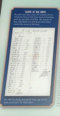
Slaves at Oak Grove
| 1 ► North Carolina, Alamance County, Burlington — Oak Grove Plantation — |
| Near North Carolina Route 62 near Kimesville Road (County Route 1113), on the right when traveling west. | |||
| 2 ► North Carolina, Alamance County, Burlington — Oak Grove Plantation — 1790-1910 — |
| Near North Carolina Route 62 at Kimesville Road (County Route 1113), on the right when traveling west. | |||
| 3 ► North Carolina, Alamance County, Burlington — St. Paul's Lutheran Church — |
| On Bellemont-Alamance Road, on the left when traveling east. | |||
| 4 ► North Carolina, Alamance County, Burlington — The John Allen House — |
| Near North Carolina Route 62, 0.2 miles south of Oakbury Road, on the right when traveling south. | |||
| 5 ► North Carolina, Alamance County, Burlington, Alamance — G-33 — Trading Path — |
| On North Carolina 62, 0.1 miles south of Pond Road, on the right when traveling south. | |||
| 6 ► North Carolina, Alamance County, Burlington, Cedarock Park — John and Polly Garrett House — |
| Near R Dean Coleman Road, 1 mile north of Friendship Patterson Mill Road. | |||
| 7 ► North Carolina, Alamance County, Burlington, Cedarock Park — Original Garrett House — |
| Near R Dean Coleman Road, 1 mile north of Friendship Patterson Mill Road. | |||
| 8 ► North Carolina, Alamance County, Burlington, Cedarock Park — Post Office — |
| Near R Dean Coleman Road, 1 mile north of Friendship Patterson Mill Road. | |||
| 9 ► North Carolina, Alamance County, Burlington, Cedarock Park — The Animals of a Turn of the Century Farm — |
| Near R Dean Coleman Road, 1 mile north of Friendship Patterson Mill Road. | |||
| 10 ► North Carolina, Alamance County, Burlington, Cedarock Park — The Corn Crib — |
| Near R Dean Coleman Road, 1 mile north of Friendship Patterson Mill Road. | |||
| 11 ► North Carolina, Alamance County, Burlington, Glencoe — Picker House and Dye House — Glencoe — |
| On Glencoe Street, on the left when traveling west. | |||
| 12 ► North Carolina, Alamance County, Burlington, Glencoe Village — African Americans in the Mill Village — |
| On Glencoe Street, on the left when traveling west. | |||
| 13 ► North Carolina, Alamance County, Burlington, Glencoe Village — Calling the Mill Village 'Home' — |
| On Glencoe Street, on the left when traveling west. | |||
| 14 ► North Carolina, Alamance County, Burlington, Glencoe Village — Children in the Mill Village — |
| On Glencoe Street, on the left when traveling west. | |||
| 15 ► North Carolina, Alamance County, Burlington, Glencoe Village — Churches — Glencoe — |
| On Glencoe Street, on the left when traveling north. | |||
| 16 ► North Carolina, Alamance County, Burlington, Glencoe Village — Cotton Dust and Poverty — |
| On Glencoe Street, on the left when traveling west. | |||
| 17 ► North Carolina, Alamance County, Burlington, Glencoe Village — Glencoe - Life in the Mill Village — From Farm to Factory — |
| On Glencoe Street, on the right when traveling west. | |||
| 18 ► North Carolina, Alamance County, Burlington, Glencoe Village — Glencoe - The Marshall Family House Site — |
| On Sarah Rhyne Road, on the right when traveling west. | |||
| 19 ► North Carolina, Alamance County, Burlington, Glencoe Village — Glencoe - The School — |
| On Sarah Rhyne Road, on the right when traveling west. | |||
| 20 ► North Carolina, Alamance County, Burlington, Glencoe Village — Glencoe - Two-Story Workers' Houses — |
| On Glencoe Street. | |||
| 21 ► North Carolina, Alamance County, Burlington, Glencoe Village — Glencoe Management Houses — |
| On Glencoe Street. | |||
| 22 ► North Carolina, Alamance County, Burlington, Glencoe Village — Glencoe Mill — 1880 - 82 — |
| On Glencoe Street, on the right when traveling west. | |||
| 23 ► North Carolina, Alamance County, Burlington, Glencoe Village — Glencoe Mill Village — Built 1880 - 82 — |
| On Glencoe Street. | |||
| 24 ► North Carolina, Alamance County, Burlington, Glencoe Village — Living in a Mill-Centered World — |
| On Glencoe Street, on the left when traveling west. | |||
| 25 ► North Carolina, Alamance County, Burlington, Glencoe Village — Lodge Hall and Barber Shop — Glencoe — |
| On Glencoe Street, on the right when traveling north. | |||
| 26 ► North Carolina, Alamance County, Burlington, Glencoe Village — Men in the Mill Village — |
| On Glencoe Street, on the left when traveling west. | |||
| 27 ► North Carolina, Alamance County, Burlington, Glencoe Village — Neighbors Divided — |
| On Glencoe Street, on the left when traveling west. | |||
| 28 ► North Carolina, Alamance County, Burlington, Glencoe Village — The Mill Buildings — Mill Design — Glencoe — |
| On Glencoe Street, on the left when traveling west. | |||
| 29 ► North Carolina, Alamance County, Burlington, Glencoe Village — Women in the Mill Village — |
| On Glencoe Street, on the left when traveling west. | |||
| 30 ► North Carolina, Alamance County, Graham — Providence Church & Cemetery — First building erected c. 1763 — |
| On North Main Street, on the right when traveling north. | |||
| 31 ► North Carolina, Alamance County, Mebane — G-30 — Hawfields Church — |
| On State Highway 119, on the right when traveling south. | |||
| 32 ► North Carolina, Alamance County, Mebane — G-34 — Trading Path — |
| On East Center Street at N. 7th Street, on the right when traveling east on East Center Street. | |||
| 33 ► North Carolina, Alamance County, Saxapahaw — History of Saxapahaw — |
| Near Church Road, 0.1 miles south of Sissipahaw Way, on the left when traveling south. | |||
| 34 ► North Carolina, Alamance County, Saxapahaw — Saxapahaw — |
| On Church Road near State Highway 87, on the right when traveling east. | |||
| 35 ► North Carolina, Alamance County, Snow Camp — G-69 — Cane Creek Meeting — |
| On West Greensboro-Chapel Hill Road at Pleasant Hill Church Road on West Greensboro-Chapel Hill Road. | |||
| 36 ► North Carolina, Alamance County, Snow Camp — G-76 — Snow Camp — |
| On Snow Camp Road, 0.2 miles south of Greensboro-Chapel Hill Road. | |||
| 37 ► North Carolina, Alleghany County, Laurel Springs — Homestead — Blue Ridge Parkway — |
| On Blue Ridge Parkway, 7 miles east of State Highway 18, on the right when traveling east. | |||
| 38 ► North Carolina, Alleghany County, Sparta — Tillers of the Land - Then and Now — Blue Ridge Parkway — |
| On Blue Ridge Parkway (at milepost 236.9), on the right when traveling south. | |||
| 39 ► North Carolina, Anson County, Morven — K-7 — Sneedsborough — |
| On U.S. 52 at Old Sneedsboro Road (North Carolina Highway 1829), on the right when traveling south on U.S. 52. | |||
| 40 ► North Carolina, Ashe County, Grassy Creek — M-15 — North Carolina / Virginia — |
| On Rugby Road (State Highway 194) at Joe Thomas Road, on the left when traveling north on Rugby Road. | |||
| 41 ► North Carolina, Ashe County, Todd — Todd Historic District — |
| On Railroad Grade Road (State Road 1100) at South Fork Church Road, on the right when traveling south on Railroad Grade Road. | |||
| 42 ► North Carolina, Beaufort County, Bath — Colonial Bath — |
| On Carteret Street (County Road 99 / 92) at South Main Street, on the left on Carteret Street. | |||
| 43 ► North Carolina, Beaufort County, Bath — BB-1 — Colonial Bath — |
| Near Carteret Street (State Highway 92) at Harding Street. | |||
| 44 ► North Carolina, Beaufort County, Bath — B-47 — Edward Teach — |
| On South Main Street near Front Street, on the left when traveling south. | |||
| 45 ► North Carolina, Beaufort County, Bath — BB-2 — Historic Bath — |
| Near Carteret Street (State Highway 92) at Harding Street. | |||
| 46 ► North Carolina, Beaufort County, Bath — BB-3 — Palmer-Marsh House — |
| On South Main Street near Carteret Street (County Road 99), on the left when traveling south. | |||
| 47 ► North Carolina, Beaufort County, Bath — B-62 — Port Of Bath — |
| On State Highway 92 / 99 just west of Brookshire, on the right when traveling east. | |||
| 48 ► North Carolina, Beaufort County, Bath — Port of Bath and Thomas Harding — |
| On Cateret Street (North Carolina Route 92) at North Main Street, on the right when traveling west on Cateret Street. | |||
| 49 ► North Carolina, Beaufort County, Bunyan — B-8 — Granville Grant — |
| On John Small Avenue (U.S. 264) near Eborn Lane, on the right when traveling east. | |||
| 50 ► North Carolina, Beaufort County, Washington — Free Church — St. Peter's Churchyard — |
| On North Bonner Street at East Main Street, on the right when traveling north on North Bonner Street. | |||
| 51 ► North Carolina, Beaufort County, Washington — Old Beaufort County Courthouse — |
| On North Market Street at West 2nd Street, on the left when traveling north on North Market Street. | |||
| 52 ► North Carolina, Beaufort County, Washington — Washington — North Carolina — |
| On West Stewart Parkway at South Respess Street, on the right when traveling east on West Stewart Parkway. | |||
| 53 ► North Carolina, Beaufort County, Washington — Washington, North Carolina — |
| On East Water Street at South Bonner Street, on the right when traveling east on East Water Street. | |||
| 54 ► North Carolina, Bertie County, Merry Hill — A-10 — Salmon Creek and Eden House: Seedbed of the Colony — |
| On Cypress Road at Governor Eden House Road, on the left when traveling east on Cypress Road. | |||
| 55 ► North Carolina, Bertie County, Windsor — Gray’s Landing — |
| On South King Street at East Water Street (U.S. 17), on the right when traveling north on South King Street. | |||
| 56 ► North Carolina, Bertie County, Windsor — Historic Windsor — |
| On South King Street at East Water Street (U.S. 17) on South King Street. | |||
| 57 ► North Carolina, Brunswick County, Carolina Shores — D-29 — South Carolina / North Carolina — |
| On U.S. 17, 0.4 miles south of Boundaryline Drive NW, on the right when traveling north. | |||
| 58 ► North Carolina, Brunswick County, Old Town — D-48 — Charles Town — |
| On River Road SE (State Highway 133) near the Town Creek Bridge, on the left when traveling south. | |||
| 59 ► North Carolina, Brunswick County, Shallotte — Shallotte — |
| On Main Street (Business U.S. 17) south of Mulberry Street, on the right when traveling north. | |||
| 60 ► North Carolina, Brunswick County, Smithville — D-14 — Arthur Dobbs — 1689–1765 — |
| On River Road SE south of Route 17, on the right when traveling south. | |||
| 61 ► North Carolina, Brunswick County, Southport — D-110 — Stede Bonnet — 1688–1718 — |
| On Ferry Road (State Highway 211) at the Deep Point Marina exit road, on the left when traveling east on Ferry Road. | |||
| 62 ► North Carolina, Brunswick County, Winnabow — D-53 — Orton Plantation — |
| On Plantation Road, 0.1 miles east of River Road (Route 133), on the left when traveling south. | |||
| 63 ► North Carolina, Buncombe County, Asheville — Ashe Monument — |
| Near the Court Plaza east of S. Spruce St.. | |||
| 64 ► North Carolina, Buncombe County, Asheville — Crossroads — |
| On North Pack Square (Alternate U.S. 74) at Broadway (U.S. 25), on the left when traveling east on North Pack Square. | |||
| 65 ► North Carolina, Buncombe County, Asheville — P-37 — Rutherford Trace — |
| On Hendersonville Road, on the right when traveling south. | |||
| 66 ► North Carolina, Buncombe County, Asheville — The Early Years In Asheville's Historic Central Square — |
| On South Pack Square (Alternate U.S. 74) east of Biltmore Avenue (U.S. 25), on the right when traveling east. | |||
| 67 ► North Carolina, Buncombe County, Bent Creek — French Broad River — |
| On Blue Ridge Parkway (at milepost 394) at North Carolina Highway 191, on the right when traveling north on Blue Ridge Parkway. | |||
| 68 ► North Carolina, Buncombe County, Black Mountain — Black Mountain — Front Porch of the Blue Ridge Mountains — |
| On Sutton Avenue just east of Cherry Street, on the right when traveling east. | |||
| 69 ► North Carolina, Buncombe County, Black Mountain — Grey Eagle — |
| On Sutton Avenue, on the left when traveling west. | |||
| 70 ► North Carolina, Buncombe County, Enka Village — Home Place of Capt. Wm. Moore — |
| On Sand Hill Road (State Highway 3412), on the right when traveling north. | |||
| 71 ► North Carolina, Burke County, Morganton — N-47 — Fort San Juan — |
| On North Green Street (State Highway 181) at Bost Road, on the right when traveling west on North Green Street. | |||
| 72 ► North Carolina, Burke County, Morganton — General Daniel Morgan — (1736-1802) — |
| On East Union Street (Business U.S. 70) at Lenoir Street, on the right when traveling south on East Union Street. | |||
| 73 ► North Carolina, Burke County, Valdese — The Waldensian Colony — |
| On Main St E (State Highway 70). | |||
| 74 ► North Carolina, Burke County, Valdese — Valdese Centennial Park — Legend of Plaques — |
| On Main Street East (U.S. 70). | |||
| 75 ► North Carolina, Burke County, Valdese — N-2 — Waldenses — |
| On Main St E (State Highway 70). | |||
| 76 ► North Carolina, Burke County, Valdese — Waldensian Heritage Museum — |
| On Rodoret Street South at Janavel Avenue Southwest, on the right when traveling south on Rodoret Street South. | |||
| 77 ► North Carolina, Cabarrus County, Concord — Concord, NC — "Harmony and Friendship" — |
| On Union Street S just south of Cabarrus Avenue West (County Road 1002), on the right when traveling south. | |||
| 78 ► North Carolina, Cabarrus County, Concord — L-84 — Red Hill — |
| On Concord Parkway N (Bypass U.S. 29) at McGill Avenue NW, on the right when traveling north on Concord Parkway N. | |||
| 79 ► North Carolina, Cabarrus County, Concord — 1 — Red Hill Tavern — |
| On Union Street South just north of Means Avenue Southeast, on the right when traveling south. | |||
| 80 ► North Carolina, Cabarrus County, Kannapolis — L-13 — Granville Grant — |
| On North Cannon Boulevard (U.S. 29) 0.1 miles north of Venus Street, on the right when traveling north. | |||
| 81 ► North Carolina, Carteret County, Davis — Welcome to Davis… — Outer Banks National Scenic Byway — |
| On U.S. 70 west of Horsehoe Road, on the right when traveling west. | |||
| 82 ► North Carolina, Carteret County, Ocracoke — Exploring Portsmouth — Cape Lookout National Seashore — |
| 83 ► North Carolina, Carteret County, Ocracoke — Methodist Church — Cape Lookout National Seashore — |
| 84 ► North Carolina, Carteret County, Ocracoke — Through These Doors — Cape Lookout National Seashore — |
| 85 ► North Carolina, Carteret County, Otway — Welcome to Otway… — Outer Banks National Scenic Byway — |
| On U.S. 70 at Otway Farm Road, on the right when traveling east on U.S. 70. | |||
| 86 ► North Carolina, Carteret County, Stacy — Welcome to Stacy… — Outer Banks National Scenic Byway — |
| On U.S. 70 north of Emilee Lane, on the left when traveling south. | |||
| 87 ► North Carolina, Carteret County, Williston — Welcome to Williston… — Outer Banks National Scenic Byway — |
| On U.S. 70 north of Donnie Davis Road, on the right when traveling south. | |||
| 88 ► North Carolina, Caswell County, Milton — Friou-Hurdle House — c. 1850 — |
| On Broad Street (State Highway 57) just east of Palmers Alley, on the right when traveling east. | |||
| 89 ► North Carolina, Caswell County, Milton — Patterson-Dodson House — c. 1850 — |
| On Academy Street (State Highway 62) just south of Broad Street (State Highway 62), on the right when traveling south. | |||
| 90 ► North Carolina, Catawba County, Catawba — Town of Catawba — Incorporated 1893 — |
| On North Main Street (State Road 10) north of 1st Avenue Northwest, on the left when traveling north. | |||
| 91 ► North Carolina, Catawba County, Hickory — Henry Weidner Robinson — |
| On NW Main Ave.. | |||
| 92 ► North Carolina, Catawba County, Hickory — Old Hickory Tavern — Birthplace of Hickory — |
| On 2nd. St. SW. | |||
| 93 ► North Carolina, Catawba County, Maiden — Drumsville — 1880-1936 — |
| On Bryant Jones Drive at North Carolina Highway 16, on the right when traveling west on Bryant Jones Drive. | |||
| 94 ► North Carolina, Catawba County, Maiden — Freedom to Worship — |
| Near Greenway Avenue north of Windy Holly Lane when traveling north. | |||
| 95 ► North Carolina, Chatham County, Moncure — H-14 — Granville Grant — |
| On U.S. 1, on the right when traveling north. | |||
| 96 ► North Carolina, Chatham County, Siler City — Siler City, N.C. — Incorporated March 7, 1887 — Collins Park — |
| On East 3rd Street (County Road 1107) at North 2nd Avenue, on the left when traveling east on East 3rd Street. | |||
| 97 ► North Carolina, Chatham County, Siler City, Albirght Township — Plikard Dederic Siler — |
| On Siler City Snow Camp Road, 0.4 miles north of Edwards Road, on the right when traveling north. | |||
| 98 ► North Carolina, Cherokee County, Andrews — Konehete — |
| On Locust Street at County Highway 1419, on the left when traveling north on Locust Street. | |||
| 99 ► North Carolina, Cherokee County, Bellview — Q-29 — North Carolina / Georgia |
| On U.S. 19, 3.8 miles south of U.S. 64, on the left when traveling south. Reported missing. | |||
| 100 ► North Carolina, Cherokee County, Murphy — Cherokee Heritage Trails — ~Tsalagi Usdi Nvnohi~ — |
| Near Peachtree Street at Alpine Street, on the right when traveling north. | |||
495 entries matched your criteria. The first 100 are listed above. Next 100 ⊳