By Mark Hilton, March 25, 2015
Redoubt No. 15 Marker (Rear)
GEOGRAPHIC SORT WITH USA FIRST Geographic Sort Title Sort Marker Number Sort Marker Number Sort N Marker Number Sort T Publication Order Sort Publication Order Sort A Erected Year Sort Most Viewed Sort Most Recent-Interest Sort Most Recently Changed Sort SEE FAQ #33 FOR DESCRIPTIONS
On Summerfield Road at Battery Avenue, on the right when traveling south on Summerfield Road.
On Satterfield Street at Riverview Avenue, on the right when traveling south on Satterfield Street.
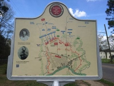
On Church Street at Arsenal Place, on the right when traveling south on Church Street.
On Water Avenue at Sylvan Street, on the right when traveling east on Water Avenue.
On Washington Street at Alabama Avenue, on the right when traveling north on Washington Street.
On Water Avenue at Washington Street, on the right when traveling east on Water Avenue.
On Lauderdale Street at Selma Avenue, on the right when traveling north on Lauderdale Street.
On Summerfield Road at Highland Avenue (U.S. 80), on the right when traveling south on Summerfield Road. Reported missing.
On Broad Street (U.S. 80) at Selma Avenue, on the right when traveling north on Broad Street.
On Water Avenue at Washington Street, on the right when traveling east on Water Avenue.
On Mabry Street south of Jeff Davis Avenue, on the right when traveling south.
On Lapsley Street at County Road 236, on the right when traveling north on Lapsley Street.
On Gault Avenue North (U.S. 11) at 5th Street (Alabama Route 35), on the right when traveling north on Gault Avenue North.
On County Road 743, 0.1 miles west of State Highway 117, on the left when traveling north.
On Main Street (Alabama Route 143) at Monument Drive, on the right when traveling south on Main Street.
Paid Advertisement
On King Street at North Ann Avenue, on the right when traveling east on King Street.
On Barnett Boulevard (Alabama Route 14) at Outer Drive, on the right when traveling east on Barnett Boulevard.
On West Bridge Street (Alabama Route 212) at North Bridge Street (Alabama Route 111), on the right when traveling west on West Bridge Street. Reported missing.
On West Tuskeena Street at North Bridge Street (Alabama Route 111), on the left when traveling west on West Tuskeena Street.
On Orline Street, 0.1 miles south of Hill Street, on the right when traveling south.
On Jasmine Hill Road at Old Montgomery Highway, on the right when traveling south on Jasmine Hill Road.
On U.S. 31 at Baker Street, on the right when traveling east on U.S. 31.
On Lamosa Street at Misella Street, on the right when traveling east on Lamosa Street.
On U.S. 31 at Old US Highway 31, on the right when traveling north on U.S. 31.
On West Meighan Boulevard (Local Road 431) east of North 22nd Street, in the median.
Near West Meighan Boulevard (Local Road 431) east of North 22nd Street, in the median.
On Broad Street at South 1st Street, in the median on Broad Street.
On Broad Street east of 1st Street, on the right when traveling east.
On U.S. 411, on the right when traveling west.
On Alford Bend Road at Gilliland Street, on the right when traveling north on Alford Bend Road.
On Jones Cemetery Road (County Route 58) west of County Route 49.
Paid Advertisement
On County Line Road (County Road 99) at County Road 343, on the right when traveling north on County Line Road.
On Pleasant Ridge Road, 0.2 miles south of Alabama Route 14, on the right when traveling south.
On Main Street at Ward Street, on the right when traveling east on Main Street.
On Church Street at South Street, on the right when traveling south on Church Street.
On County Route 47, 0.4 miles north of County Route 177, on the left when traveling north.
Near Main Street, 0.1 miles south of Alabama Route 173, on the right when traveling north.
On Main Street, 0.1 miles south of Alabama Route 173, on the right when traveling north.
On County Road 89 at County Road 109, on the right when traveling south on County Road 89.
On Alabama Route 227 at Busbey Ave, on the right when traveling north on State Route 227.
On Bradley Avenue east of Bonner Avenue, on the right when traveling east.
On Bellefonte Road (County Road 33) 0.8 miles east of Lee Highway/John T Reid Parkway (U.S. 72), on the left when traveling east.
On John T Reid Parkway (U.S. 72) at Church Street, on the right when traveling south on John T Reid Parkway.
Near Veterans Drive (Alabama Route 35) at Lee Highway (U.S. 72), on the right when traveling north.
Near Veterans Drive (Alabama Route 35) north of Lee Highway (U.S. 72), on the right when traveling north.
On W Maple Avenue near N Houston Street.
On East Maple Avenue at North Houston Street, on the right when traveling east on East Maple Avenue.
Paid Advertisement
On Old Mount Carmel Road (County Route 85) at Ohio Avenue, on the left when traveling west on Old Mount Carmel Road.
Near Sawmill Road, on the right when traveling south.
On West Main Street (State Highway 117), on the left when traveling south.
On Myrtle Place north of College Street, on the left when traveling north.
On City Park Road south of Kentucky Avenue (Alabama Route 17), on the left when traveling south.
On Eastern Valley Road (County Road 18) 0.1 miles north of Rosser Loop Drive, on the left when traveling north.
On 60th Street North, in the median.
On Highland Avenue South, on the right when traveling west.
On Shannon Oxmoor Road at Shades Creek Circle, on the right when traveling west on Shannon Oxmoor Road.
On 60th Street North, in the median.
On Martin Luther King Drive, on the right when traveling south.
Near 3rd Street Southwest south of Cotton Avenue Southwest, on the right when traveling south.
On Old Springville Road / County Road 30, on the left when traveling north.
On Hollywood Boulevard east of Malaga Avenue, on the left when traveling east.
On Montevallo Road, on the right when traveling east.
Paid Advertisement
On Tannehill Road, 0.6 miles north of Tannehill Park, on the right when traveling south.
On Tannehill Road, 0.7 miles north of Confederate Parkway, on the left when traveling north.
On Church Street, on the right when traveling east.
On Stone River Road north of Old Leeds Lane, on the left when traveling north.
On Center Point Road (State Highway 75) south of Main Street, on the left when traveling north.
On Main Street east of Center Point Road (State Highway 75), on the left when traveling east.
On North Chalkville Road at Main Street (U.S. 11), on the right when traveling south on North Chalkville Road.
On Gadsden Highway, 0.1 miles east of Calumet Parkway, on the right when traveling east.
On East Main Street (U.S. 278) at Bankhead Street, on the right when traveling east on East Main Street.
On Pond Street (Alabama Route 17) at 1st Avenue NE, on the right when traveling north on Pond Street.
On Alabama Route 207 south of Hammond Street, on the right when traveling south.
On Lee Highway (U.S. 72) at Big Oak (County Route 107), on the right when traveling east on Lee Highway.
On Alabama Route 101 at Putnam Parkway, on the left when traveling north on State Route 101.
On Appleby Blvd. at Cypress Mill Road on Appleby Blvd..
On Hermitage Drive at North Court Street, on the right when traveling north on Hermitage Drive.
On East Ervine Avenue at North Court Street, on the right when traveling west on East Ervine Avenue.
Paid Advertisement
On North Court Street, 0.1 miles north of Hermitage Drive, on the right when traveling north.
On East College Street, on the right when traveling east.
On Surveyor Road near Cloverdale Road (Alabama Route 157), on the left when traveling west.
On Military Road at Hermitage Drive on Military Road.
On McFarland Park Road, on the right when traveling west.
On Meridian Street at East Hawthorne Street, on the right when traveling south on Meridian Street.
On Veterans Drive at South Magnolia Street, on the right when traveling east on Veterans Drive.
On Hermitage Drive just north of North Seminary Street, on the right when traveling south.
On North Court Street south of East Irvine Avenue, on the right when traveling south.
On South Magnolia Street, on the right when traveling north.
On Florence Boulevard (U.S. 43) at Sweetwater Avenue, on the right when traveling east on Florence Boulevard.
On East Tennessee Street (U.S. 72) at Short Court Street, on the left when traveling west on East Tennessee Street.
On Plantation Springs Drive.
Paid Advertisement
On Lee Highway (U.S. 72) at County Route 33, on the right when traveling west on Lee Highway.
On Lee Highway (U.S. 72) at County Route 635, on the right when traveling east on Lee Highway.
Near McLean Drive, 4.5 miles south of U.S. 72.
On Wheeler Street/Lambs Ferry Road (Alabama Route 207) south of Lee Street (County Route 66), on the left when traveling south.
On Alabama Route 101 at County Route 646, on the right when traveling north on State Route 101.
24083 entries matched your criteria. Entries 201 through 300 are listed above.
⊲ Previous 100 —
Next 100 ⊳