By Mike Stroud, July 15, 2012
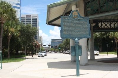
Sinking of the Maple Leaf Marker, South end of South Hogan Street
GEOGRAPHIC SORT Title Sort Marker Number Sort Marker Number Sort N Marker Number Sort T Publication Order Sort Publication Order Sort A Erected Year Sort Most Viewed Sort Most Recent-Interest Sort Most Recently Changed Sort SEE FAQ #33 FOR DESCRIPTIONS
On Southern Teminus of S Hogan Street, in the median.
Near Water Street at Park Street when traveling west.
On Phelps Street near Hubbard Street, on the right when traveling east.
On E. Forsyth Street at N.Liberty Street, on the left when traveling east on E. Forsyth Street.
On North Palafox Street at West Chase Street, on the left when traveling south on North Palafox Street.
On South Adams Street at Church Street, on the left when traveling north on South Adams Street.
On North 10th Avenue at East Salamanca Street, on the right when traveling south on North 10th Avenue.
On Scenic Highway (U.S. 90) at Langley Avenue, on the right when traveling north on Scenic Highway.
On East Strong Street at North Hayne Street, on the left when traveling east on East Strong Street.
On North Palafox Street at East Jackson Street, in the median on North Palafox Street. Reported permanently removed.
Near East Palafox Street at East Government Street.
Near Fort Pickens Road, 9.9 miles west of Pensacola Beach Road (State Road 399). Reported missing.
Near Fort Pickens Road, 9.8 miles west of Pensacola Beach Boulevard (State Road 399).
Near Fort Pickens Road near Pensacola Beach Boulevard (State Road 399).
Paid Advertisement
Near Taylor Road south of Tow Road, on the right when traveling south.
On Market Street at Avenue F, on the left when traveling north on Market Street.
On Holly Drive, 0.2 miles north of West Washington Street (U.S. 90), on the right when traveling north.
On North Main Street at Pecan Lane, on the left when traveling north on North Main Street.
On River Landing Road, 0.4 miles south of U.S. 90, on the right when traveling south.
On Maple Street at East Washington Street (U.S. 90), on the right when traveling north on Maple Street.
On Franklin Street just west of North Madison Street (County Road 65), on the right when traveling west.
Near Washington Street at North Adams Street (State Road 267). Reported permanently removed.
Near East Jefferson Street (U.S. 90) 0.1 miles east of North Love Street, on the left when traveling east.
On East King Street at North Madison Street (State Road 12), on the right when traveling west on East King Street.
On Cape San Blas Road, 1.1 miles west of State Road 30A, on the right when traveling west.
On Hatley Street (U.S. 41/129) at Central Avenue Northwest, on the left when traveling east on Hatley Street.
On U.S. 41/129 just south of Chan Bridge Drive (15th Avenue Northwest), on the left when traveling south.
On Spring Street (U.S. 41) east of Wesson Street, on the right when traveling east.
On U.S. 41 (Local Road 25) just east of Wesson Street, on the right when traveling east.
On State Road 80 at Collingswood Parkway, on the right when traveling west on State Road 80.
Paid Advertisement
Near Cortez Boulevard (County Road 550) 1.5 miles south of Pine Island Drive.
Near Cortez Boulevard (County Road 550) 6.5 miles west of Commercial Way (U.S. 19), on the right when traveling west.
On North Main Street at North Broad Street (U.S. 98), on the left when traveling south on North Main Street.
On Cortez Boulevard, on the right when traveling south.
On North Pinewood Avenue at East Brandon Boulevard (State Road 60), on the left when traveling north on North Pinewood Avenue.
On East Brandon Boulevard (State Road 60) at North Pinewood Avenue, on the left when traveling east on East Brandon Boulevard.
On North Collins Street at East Gilchrist Street, on the left when traveling north on North Collins Street. Reported permanently removed.
On Bayshore Boulevard north of West Gandy Boulevard, on the left when traveling north.
On Jackson Street (U.S. 41) near North Franklin Street, on the right.
On South Ashley Drive at Channelside Drive, on the right when traveling north on South Ashley Drive. Reported missing.
Near East Harrison Street near North Morgan Street.
Near U.S. 301, 0.2 miles south of East Martin Luther King Jr Boulevard, on the right when traveling south.
Near University Dr. near West Kennedy Boulevard.
On Bayshore Boulevard at Hyde Park Place, on the right when traveling north on Bayshore Boulevard. Reported permanently removed.
On North Ashley Drive south of East Twiggs Street, on the left when traveling north. Reported missing.
On East Street, on the right when traveling north.
Paid Advertisement
On East Kennedy Boulevard (U.S. 41) near East Street, on the right when traveling west.
Near U.S. 301, 0.3 miles south of East Dr Martin Luther King Jr Boulevard (Florida Route 574), on the right when traveling south.
Near West Cypress Street, 0.5 miles west of North Reo Street, on the left when traveling west. Reported missing.
Near U.S. 301, 0.2 miles south of East Martin Luther King Jr Boulevard, on the right when traveling south.
Near U.S. 301, 0.2 miles south of East Martin Luther King Jr Boulevard, on the right when traveling south.
Near University Drive north of West Kennedy Boulevard (State Road 60), on the right when traveling north.
On East Harrison Street near North Morgan Street, on the left.
Near North Boulevard south of West Clinton Street, on the left when traveling north.
On Henderson Boulevard (State Road 685) at South Bradford Avenue, on the left when traveling south on Henderson Boulevard.
On Lafayette Street (U.S. 90) at Jefferson Street (State Road 73), on the right when traveling east on Lafayette Street.
On Lafayette Street at Caledonia Street, on the left when traveling west on Lafayette Street.
On Lafayette Street (U.S. 90) at Caledonia Street, on the right when traveling east on Lafayette Street.
Near Lafayette Street (U.S. 90) at Madison Street, on the right when traveling east.
On Lafayette Street (U.S. 90) at Jackson Street, on the right when traveling east on Lafayette Street.
On Lafayette Street (U.S. 90) at Russ Street, on the right when traveling west on Lafayette Street.
On Lafayette Street (U.S. 90) at Wynn Street, on the right when traveling west on Lafayette Street.
Paid Advertisement
On Blue Springs Road (County Road 164) at Marble Court, on the right when traveling east on Blue Springs Road.
On Courthouse Circle (U.S. 90) at South Jefferson Street (U.S. 19), on the right when traveling east on Courthouse Circle.
Near West Washington Street (Florida Route 10) at North Hickory Street.
On Jefferson Street (Courthouse Circle) (U.S. 19) at Washington Street (U.S. 90), on the left when traveling north on Jefferson Street (Courthouse Circle).
Near Orange Avenue at West Line Street, on the right when traveling north.
Near Edwards Drive east of Monroe Street, on the left when traveling east.
On First Street at Jackson Street, on the right when traveling west on First Street.
On Monroe Street south of Bay Street, on the left when traveling south. Reported permanently removed.
On First Street at Vivas Court, on the right when traveling east on First Street.
On Natural Bridge Road, on the right when traveling west.
Near Natural Bridge Road, 6 miles east of Woodville Highway (State Highway 363), on the left when traveling east.
On Natural Bridge Road, 6 miles east of Woodville Highway (State Highway 363), on the left when traveling east.
Near Natural Bridge Road, 6 miles east of Woodville Highway (State Highway 363), on the left when traveling east.
Near University Way just east of Convocation Way when traveling east.
Near Natural Bridge Road, 6 miles east of Woodville Highway (State Highway 363), on the left when traveling east.
Near Capital Circle Southwest (State Road 263) 0.3 miles west of Terminal Loop Road. Reported missing.
Paid Advertisement
Near Natural Bridge Road, 6 miles east of Woodville Highway (State Highway 363), on the left when traveling east.
On South Meridian Street north of East Madison Street, on the right when traveling north.
On Monroe Street at Apalachee Freeway on Monroe Street.
On North Martin Luther King Jr. Boulevard at West Park Avenue, on the left when traveling north on North Martin Luther King Jr. Boulevard.
On South Meridian Street north of East Madison Street, on the right when traveling north.
On E. Park Avenue at S. Calhoun Street on E. Park Avenue. Reported permanently removed.
On East Park Avenue at South Calhoun Street, on the right when traveling east on East Park Avenue.
Near North Martin Luther King Jr. Boulevard, on the left when traveling north.
On North Calhoun Street, 0.1 miles south of East Carolina Street, on the right when traveling south.
On Seminole Drive at Santa Rosa Drive, on the left when traveling north on Seminole Drive.
On Santa Rosa Drive at Old Fort Drive, on the right when traveling east on Santa Rosa Drive.
On East Base Street (U.S. 90) at Southwest Shelby Avenue, on the right when traveling east on East Base Street.
On Northwest Meeting Avenue, 0.1 miles north of Northwest Livingston Street, on the right when traveling north.
On West Base Street (U.S. 90), on the left when traveling east.
On 4th Avenue East east of 12th Street East, on the right when traveling east.
On 4th Avenue East, 0.1 miles west of 14th Street East, on the right when traveling east.
Paid Advertisement
Near Desoto Memorial Highway (75th Street NW), 0.2 miles north of 24th Avenue NW when traveling north.
On 3rd Street West north of 9th Avenue West, on the right when traveling north.
On 4th Avenue East east of 12th Street East, on the right when traveling east.
On Manatee Avenue East (Florida Route 64) at 14th Street East, on the right when traveling east on Manatee Avenue East.
On Patten Avenue east of Church Street, on the right when traveling east.
347 entries matched your criteria. Entries 101 through 200 are listed above.
⊲ Previous 100 —
Next 100 ⊳