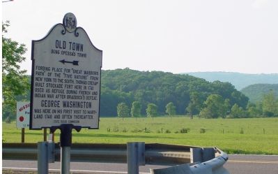
Fording place for “Great Warriors Path” from New York to the South. Thomas Cresap built stockade fort here in 1741 used as a refuge during French and Indian War after Braddock’s defeat.
George Washington
was here on his first visit to . . . — — Map (db m447) HM
Baltimoreans associated the name McDonogh with a well-known private school founded in 1873. Buried here are the parents of the school's founder, Irish natives John (1734-1809) and Elizabeth McDonogh (1747-1808).
John McDonogh, a brickmaker, . . . — — Map (db m6633) HM
In April 1755, Frederick Town was a planning center for a major campaign in the French and Indian War (175-1763). General Edward Braddock arrived from England and later 1,400 British Troops joined him to stop the French from taking land claimed . . . — — Map (db m242001) HM
On April 23, 1755 At a Tavern located near this spot General Edward Braddock Colonel George Washington and Benjamin Franklin Met to plan the British assault on Ft. Dusquesne During the French & Indian War This plaque erected by the Kiwanis Club . . . — — Map (db m2725) HM
This tablet is erected
to the Glory of God
and
in grateful recognition of those
who organized this congregation
and have maintained it for
two hundred years
1738 Congregation organized.
1743 Log church built on the Monocacy. . . . — — Map (db m14022) HM
General Edward Braddock traveled over this road in April 1755 (in a coach and six horses purchased from Gov. Horatio Sharpe of Maryland)after a protracted conference in Frederick with Benjamin Franklin and others concerning the securing of teams, . . . — — Map (db m1247) HM
By coach and six horses purchased from Gov. Horatio Sharpe of Maryland. Braddock traveled this route west in April, 1755. After 10-day meeting in Frederick with Benjamin Franklin and others to arrange for teams, wagons and supplies for the . . . — — Map (db m129188) HM
Veteran of French and Indian War, early settler, head of family of Revolutionary patriots buried in the cemetery of homestead near here. At outset of the Revolution he and his sons Abraham, Basil, Daniel, John and his nephew Samuel were listed with . . . — — Map (db m203247) HM
General Braddock's 3rd camp on his march to Fort Duquesne June 16, 1755. The route, later known as the Old Braddock Road, passes to the southeast of the National Road. Captain Orme's diary says "we entirely demolished three wagons and shattered . . . — — Map (db m439) HM
General Braddock's 6th camp on the march to Fort Duquesne Saturday and Sunday June 20th and 21st, 1755. Washington was forced to remain behind with a guard on account of "violent fevers" until cured by "Dr. James's Powders (one of the most excellent . . . — — Map (db m135626) HM
On the march to Fort Duquesne June 19th, 1755. By Washington’s advice, Braddock pushed forward from Little Meadows to this camp with 1200 chosen men and officers leaving the heavy artillery and baggage behind to follow by easy stages under Colonel . . . — — Map (db m357) HM
General Braddock's 4th camp on the march to Fort Duquesne June 17, 1755. Washington arrived here after Braddock's defeat July 15th, 1755. Washington also stopped here May 9th, 1754, July 7th or 8th, 1754, October 1st, 1770, November 26th, 1770 and . . . — — Map (db m361) HM
In 1785 Daniel Grant of Baltimore acquired an 1100 acre tract of land called "Cornucopia." The town of Grantsville is located in the center of this tract, named in honor of Daniel Grant. Garrett was established as a separate county in 1872, . . . — — Map (db m310833) HM
Lieutenant of Volunteers
French and Indian War,
Magistrate of the 1st. court,
Montg. Co. MD. 1777
Major of Maryland Battalion
Member of Committee to
effect resolutions of
first Continental Congress. — — Map (db m72752) HM
(East Face)
N.S.D.A.R. Memorial to the Pioneer Mothers of the Covered Wagon Days.
(North Face)
This the first military road in America beginning at Rock Creek and Potomac River, Georgetown, Maryland, leading our pioneers . . . — — Map (db m231340) HM
On April 15, 1755 a British seaman wrote in his diary:
On the 15th: Marched at 5 in our way to one
Dowden's, a Publichouse ... and encamped upon
very bad ground on the side of a hill. We got our
tents pitched by dark when the wind shifted . . . — — Map (db m167055) HM
General Edward Braddock in April 1755, accompanied by Gov. Horatio Sharpe of Maryland, traveled this road in a coach and six horses, on his way to Frederick, Md. to meet Benjamin Franklin and George Washington, to arrange for teams for the Fort . . . — — Map (db m1012) HM
To commemorate the encampment in Maryland of Maj. Gen. Edward Braddock and his men at Owen's Ordinary, now Rockville, April 20, 1755. This stone is placed by the Janet Montgomery Chapter, Daughters of the American Revolution, Mrs. Morris L. Croxall, . . . — — Map (db m77) HM
Born in Ireland; served in the British Army in the French & Indian War. Joined the American Revolution as the most experienced general in the Continental Army. Led the invasion of Canada where he was killed in the Battle of Quebec, becoming the . . . — — Map (db m50480) HM
During the French and Indian War, the British expelled some 11,500 Acadians from the Canadian Maritimes, dispersing them among the North American colonies and to France. Four ships carrying over 900 exiles arrived in Maryland in November 1755. . . . — — Map (db m258641) HM
Throughout the 18th Century, the major colonial powers of France and Great Britain were vying for control of North America. By the 1750's the British extended their settlements westward over the Appalachian Mountains and the French moved south out . . . — — Map (db m166798) HM
Colonial stone fort built 1756 for Province of Maryland by Gov. Horatio Sharpe to protect frontier against French and Indians after Braddock’s defeat. Detention camp for British prisoners 1776–83. Occupied 1861–2 by Union troops. George Washington . . . — — Map (db m681) HM
A Ghost in the Ground.
Before you is the foundation of “The Governor’s House,” the building that served as the officers’ quarters, ceremonial hall and storeroom for Fort Frederick. What did that building look like? We know the size and general . . . — — Map (db m823) HM
Colonial stone fort built 1756 for Province of Maryland by Gov. Horatio Sharpe to protect frontier against French and Indians after Braddock’s defeat. Detention camp for British prisoners 1776–83. Occupied 1861–2 by Union troops. George Washington . . . — — Map (db m680) HM
Ca. 8000 BC
First Native Americans enter the Cumberland Valley area as roving hunters.
Ca. 1000 BC
Permanent villages are established by Native Americans. the primary tribes include Susquehanna and Algonquian.
Ca. 1735 . . . — — Map (db m146012) HM
Third dwelling was built by Jonathan Hager, founder of Hagerstown Maryland, 1762; Captain of Scouts, French and Indian War, 1755–1763; member of the Non-Importation Association and of the Committees of Safety and of Observation, 1775; member of the . . . — — Map (db m1159) HM
Fort Coombe, a Maryland stockaded fort of 1755–56 located north of this point. One of the frontier forts during the French and Indian War. The survey of the Mason and Dixon Line during 1763–68 placed it in Pennsylvania instead of Maryland. — — Map (db m833) HM
Lieut. Stoddert and twenty men erected and garrisoned a block house and stockaded fort near here on the property of Evan Shelby in 1755 after Braddock’s defeat. It was abandoned in 1756-7 after Fort Frederick was completed. — — Map (db m508) HM
General Edward Braddock in April 1755 (driven in his coach and six horses) crossed into Virginia near this point on his way to Fort Cumberland, after ten days’ conference with Benjamin Franklin and others in Frederick, Md., arranging for teams and . . . — — Map (db m1966) HM
An important point during the French and Indian War 1753-1758.
George Washington
given authority to locate the "Federal City" at any point on the Potomac between Conococheague and the eastern branch. He inspected this site October 1790 but . . . — — Map (db m3911) HM
Built in 1756 on this house-lot Number Six under decree of the Great and General Court of the Province of the Massachusetts Bay in compliance with urgent appeal from the homesteaders it served as sole refuge from their allied foes the French and . . . — — Map (db m118713) HM
Built in March 1756, as westernmost stockade and blockhouse to protect Massachusetts from French and Indian attack. Defended on July 11, 1756 despite the scalping of three soldiers. — — Map (db m118714) HM
Original Williams College building, completed in 1790 as a free school under bequest of Col. Ephraim Williams, killed at Battle of Lake George, Sept. 8, 1755, and for whom Williamstown is named. The free school became Williams College in 1793. — — Map (db m118584) HM
The First Burial Ground is the presumed buying place of Norton's pioneer settler's.
William Witherell, who died in September 1691, is buried in the West end of the burial ground. When the land was passed to Nathaniel Witherell by his father,the . . . — — Map (db m52379) HM
Brought from the siege of
Louisburg
by Nathaniel Knapp Jr. 1759
preserved by his son
Isaac Knapp
as a memorial to his father
and also to his brother
Jacob Knapp
who served at Bunker Hill
and was a member of the . . . — — Map (db m115543) HM
Original plot given by the first settler, Richard Tarr, who was buried here in 1732. Here lie most of the early settlers and many of the officers and soldiers of the French and Indian, Revolutionary and 1812 Wars. — — Map (db m48841) HM
Six rods easterly stood Burke Fort the first and largest, and also the first building in Fall Town. Built in 1738/39 by John Burke it was six rods square and contained eight houses. Fifty persons took shelter here during the old French and Indian . . . — — Map (db m48254) HM
Site of the second fort and building in Fall Town, erected in 1739 by Samuel Connable. Its original timbers are still in the house on a knoll to the northwest. — — Map (db m48774) HM
The Lieutenant's son Ebenezer, later deacon of the church and first town treasurer, built a fort ten rods east of here in 1740/41. It was unsuccessfully attacked by Indians in 1746 during King
George's War. — — Map (db m48777) HM
Built in 1740 on this site. The first Proprietor's Meeting in Fall Town was held here in 1741. The Lieutenant's son Eliakim was shot by Indians in 1747 while working west of the fort walls. — — Map (db m48011) HM
Indian land called Pocomtuck, settled by men from Dedham in 1671. Attacked by Indians, burnt, and abandoned in 1675. Reoccupied and attacked in 1704 by French and Indians, who took 47 lives, and carried off 112 captives to Canada, of whom 60 were . . . — — Map (db m288313) HM
Site of the
Old Indian House
Built by
Ensign John Sheldon 1698
It stood for 144 years
testifying to the tragedy of
Feb. 29, 1703
its stout door
which kept at bay
the French and Indians
13 now safe in Memorial Hall . . . — — Map (db m141341) HM WM
Eunice Williams, wife of the Reverend John Williams "The Redeemed Captive," was killed at this place on March 1, 1704, during the Deerfield massacre. — — Map (db m29069) HM
Site of the First Church of Hawley
Erected 1793
Reverend Jonathan Grout 1st Pastor
This memorial placed by the
sons and daughters of Hawley
August 10, 1935 — — Map (db m25876) HM
Nathaniel Dickinson lived here nineteen years in a fortified house but was scalped and killed by the Indians on April 15, 1747, at Pachaug Hill. — — Map (db m42634) HM
Site of First Permanent Settlement in Shelburne, Mass. 1760 Martin Severance 1718 - 1810 Scout in French and Indian Wars Scout with Rogers Rangers Revolutionary soldier Marked by Dorothy Quincy Hancock Chapter, Daughters of the American . . . — — Map (db m59639) HM
Two miles distant on Indian Hill is the site of an Indian stronghold and storehouse for corn, Quaboag Old Fort, and of the Indian village of Ashquoach. — — Map (db m48776) HM
Four miles distant on the summit of East Waddaquodduck Mountain is Steerage Rock, a landmark on the Indian trail which became known as the Bay Path and a guidepost to the pioneer settlers of the Connecticut Valley from
Massachusetts Bay in 1636. — — Map (db m88553) HM
Indian land called Norwottock. Settled in 1650 by families from Hartford. The Regicides Generals Goffe and Whalley were concealed for fifteen years in the Pastor's house. — — Map (db m48757) HM
Indian land called Norwottock. Settled in 1650 by families from Hartford. The Regicides Generals Goffe and Whalley were concealed for fifteen years in the Pastor's house. — — Map (db m298016) HM
Site of homestead of Captain Jonathan Danforth, pioneer of Billerica and famous surveyor. "He rode
the circuit, chain'd great towns and farms to good behavior; and by well worked stations he fixed their bounds for many generations. " — — Map (db m104020) HM
Near this spot stood the John Rogers homestead, which was destroyed in the Indian massacre of 1695, and the entire family killed. — — Map (db m48838) HM
While Thomas Eames sought help from Boston February 1, 1676, the Indians attacked his house which stood nearby. His wife and five children were slain and four children captured. — — Map (db m195313) HM
On Wickasee Island (now Tyngs Island) in the Merrimac dwelt Wannalancet, last sachem of the Pennacook Confederacy, and like his father Passaconway, a faithful friend to the English. — — Map (db m48022) HM
One-eighth of a mile north is the site of the Haynes Garrison House the home of Deacon John Haynes. Here the settlers by their brave defense saved the town when King Philip and his Indian warriors attacked Sudbury in April, 1676. — — Map (db m300804) HM
Settled by men from Charlestown under Captain Edward Johnson. Named in 1642 after Woburn, Bedfordshire. Here was born and grew up together Colonel Loammi Baldwin, the Engineer, and Benjamin Thompson (Count Rumford), Philanthropist and Scientist. — — Map (db m48764) HM
The north line of Ponkapoag Plantation second of the Apostle Eliot's Praying Indian towns, set apart by the Dorchester Proprietors in 1657. — — Map (db m308384) HM
Erected in grateful recognition of the services of the men of Walpole and vicinity in the French and Indian War.
They enlisted not for a livelihood, but with intent to return to their farms and trades being chiefly influenced . . . — — Map (db m283856) WM
He arrived in Hardwick about 1754 settling on a farm, now Upper Church Street. A lawyer, he was graduated from Harvard in 1732. Ruggles distinguished himself in the French and Indian War, thus becoming the highest ranked colonist of this time. He . . . — — Map (db m148232) HM
Up this road on Mayo's Hill, are the remains of a bastioned fort built by Huguenots driven from France by the Revocation of the Edict of Nantes. Their prosperous settlement was interrupted by Indian attacks in 1696, and finally abandoned in 1704. — — Map (db m48787) HM
From this ford branched trails to Woodstock, Brookfield and Sturbridge. This way ran the Post Route established in 1672 "to goe monthly" from New York to Boston. Here, June 5, 1676, Major Talcott's Connecticut troops passed to join the final . . . — — Map (db m48784) HM
Here
from 1781 to 1788
dwelt
General Rufus Putnam
Soldier of the Old French War
Engineer of the Works
which compelled the British Army
to evacuate Boston
and of the Fortifications of
West Point
Founder and Father
of Ohio. . . . — — Map (db m198409) HM
(middle plaque)
Major General Artemas Ward, son of Col. Nahum Ward, H.U. 1748; 1762 a Justice, and 1776, Chief Justice of the C.C. Pleas for the County of Worcester. 1758 a Major in the expedition against Canada. 1759 appointed Col.; 1766 . . . — — Map (db m254819) HM
October 29, 1901
Dedicated to the memory of Samuel Bemis
the first settler of Spencer and Captain
Edmond Bemis who fought in the
French and Indian War — — Map (db m198335) HM
This Memorial is in Honor of
Capt. Edmond Bemis,
Son of Samuel Bemis, founder of
Spencer. He settled near this
place in 1750, served in the
French and Indian Wars, was a
Lieutenant at the reduction
of Louisburg in 1745, and
Captain . . . — — Map (db m198333) HM WM
Chief Wawatam was revered for his bravery and fidelity
Chief Wawatam, an Ojibway Indian living at the Straits of Mackinac, treated the British fur trader Alexander Henry as a brother. During the Indian attack on Fort Michilimackinac in . . . — — Map (db m214253) HM
Worlds collide in Mackinac’s “Middle Ground” Charles Michel de Langlade was an Odawa war chief, diplomat, fur trader and a French officer. He was one of the most influential people in the Great Lakes during the 1700s, due to his reputation as . . . — — Map (db m154700) HM
This fort, built about 1715, put French soldiers at the Straits for the first time since 1701. French authority ceased in 1761 when the British troops entered the fort. On June 2, 1763, during Pontiac's uprising, Chippewa Indians seized the fort, . . . — — Map (db m7670) HM
Nissowaquet, a legendary Odawa Nissowaquet (Nosawaguet, Sosawaket, La Fourche), Odawa chief; the name evidently comes from Nassauaketon, meaning “forked river,” the designation of one of the four Odawa bands; b. 1715; d. 1797. Nissowaquet . . . — — Map (db m154698) HM
Mackinac Island is no stranger to hostility, and many have fought for its highly strategic location in the Great Lakes. Some of these battles occurred before Europeans arrived in North America, while others were an integral part of American . . . — — Map (db m278115) HM
Built near here in 1686 by the French explorer Duluth, this fort was the second white settlement in lower Michigan. This post guarded the upper end of the vital waterway joining Lake Erie and Lake Huron. Designed to bar English traders from the . . . — — Map (db m212488) HM
The first permanent French settlement in the Detroit region was built on this site in 1701. The location was recommended by Antoine de la Mothe Cadillac, who wished to move the fur trade center south from Michilimackinac. Cadillac's plan was . . . — — Map (db m21853) HM
Near this site, in late July 1763, the British and Indians fought the fiercest battle of Chief Pontiac's uprising. As Captain James Dalyell led about 260 soldiers across Parent's Creek, the Indians launched a surprise attack which devastated the . . . — — Map (db m21846) HM
Chapman Abraham
During the French and Indian War (1754-1763), the British took Canada from France and with it possession of French forts in the western Great Lakes region, including Detroit. The post remained an important center of trade . . . — — Map (db m33485) HM
Council Point
On April 27, 1763, Obwandiyag, an Odawa who was also called Pontiac, assembled a council of warriors from various tribes near this site. He urged them to fight to maintain control of their land and their way of life. For more . . . — — Map (db m88332) HM
On bluff to south stood Ft. Rosalie, established by the French in 1716. Became nucleus of settlements from which the Miss. Territory was founded. Near this marker stood the French warehouse that was a center of bloodshed during the Natchez Massacre . . . — — Map (db m126870) HM
Near here, on May 26, 1736, French and Choctaw invaders under Bienville were soundly repulsed by Chickasaws defending the Ackia, Apeony, and Chukafalaya villages. Many French casualties occurred. — — Map (db m102783) HM
At the end of the French and Indian War in 1763, Great Britain gained control of the territory between the Appalachians and the Mississippi River except for the New Orleans area. The northern boundary of West Florida was first established at 31° . . . — — Map (db m87366) HM
English Side
A Frenchman, Pierre Esprit Radisson, wrote in 1659 of a nation” of extraordinary height and bigness” (the Osage) living up the Missouri River. Marquette and Joliet’s 1674 maps show the village of the Osage, and some of . . . — — Map (db m86416) HM
Daniel Boone and his fellow travelers—his sons' and daughters' families, other relations, friends and family slaves—came to Missouri in 1799. Boone was 65 years old and already famous in America and Europe, thanks to his "autobiography" by John . . . — — Map (db m133211) HM
On April 30, 1789, George Washington, standing on the balcony of Federal Hall on Wall Street in New York, took his oath of office as the first President of the United States.
Born in 1732, into a Virginia planter family, he learned the . . . — — Map (db m179401) HM
In honor and memory of Brigadier General James Reed Born at Woburn, Mass. Jan. 8, 1723 Died at Fitchburg, Mass. Feb 13, 1807 One of the proprietors of Monadnock No. 4, and a founder of this town. A leader in its civil and religious life. . . . — — Map (db m152116) HM WM
This veteran Captain of the French and Indian War, born in Woburn, Mass., settled here about 1765 as an original proprietor of Monadnock No. 4, now Fitzwilliam. After the Battle of Lexington, he recruited several companies to form the Third New . . . — — Map (db m136527) HM WM
On the site of the
Meetinghouse of the Pioneers
Erected 1784 the Town of
Lancaster builds this
monument in memory of
her citizens who served
in the wars of the Country
“Dulce et Decorum Est Pro Patria Mori”
CIVIL . . . — — Map (db m157329) HM WM
Born in Boston and a veteran of the 1758 Battle of Ticonderoga. As a known participant in the Boston Tea Party, for his own and his children’s safety, he walked to North Haverhill in early 1774. He later served in the Northern Army under Gen. Gates . . . — — Map (db m77798) HM
1033 entries matched your criteria. Entries 101 through 200 are listed above. ⊲ Previous 100 — Next 100 ⊳